|
Chingola
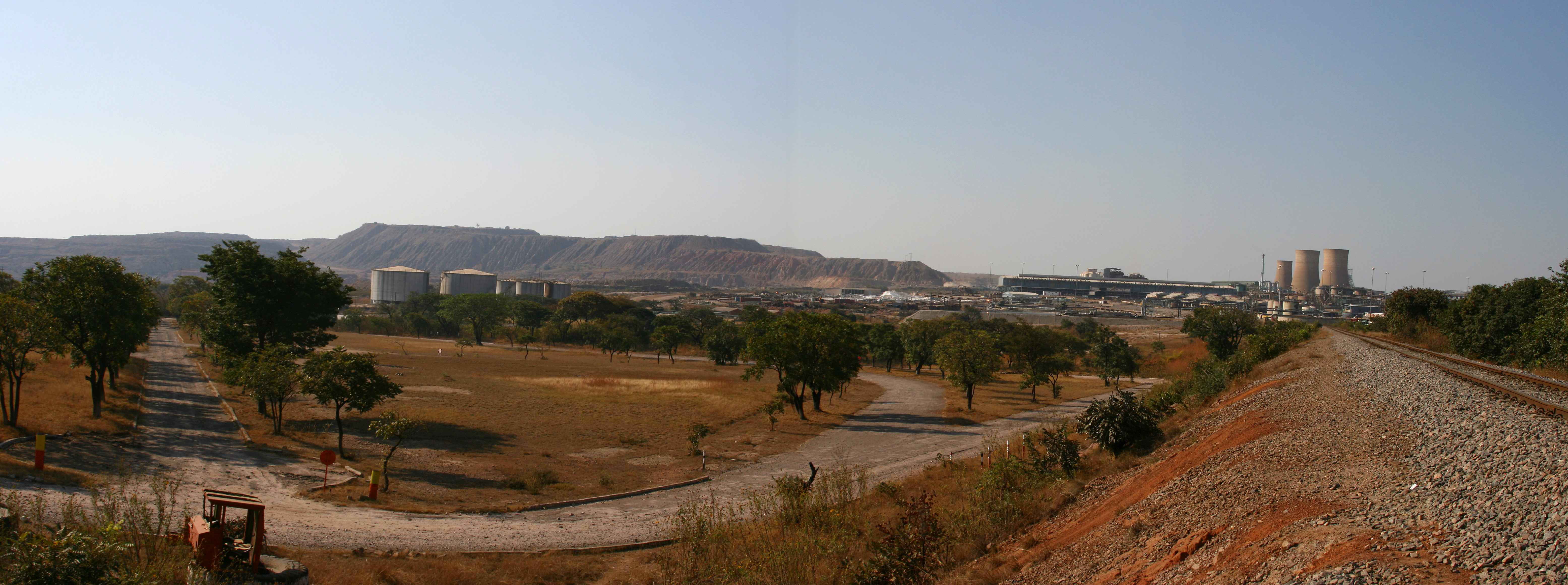
Chingola is a town in Zambia's Copperbelt Province, the country's copper-mining region, with a population of 256,560 (2022 census). It is the home of Nchanga Copper Mine, a deep-shaft high-grade content copper mining operation, which subsequently (in the 1960s) led to the development of two open pit operations, Chingola Open Pit and then Nchanga Open Pit (the latter being the second largest open cast mine in the world). History Chingola was founded in 1943, somewhat later than most other Copperbelt Province towns. Chingola was built to service the newly opened Nchanga Copper mine. Demographics Mines Situated at the north-west end of the Copperbelt Province, the Nchanga Mines Open Pit workings lie in an arc 11 km long around the west and north of the town, covering nearly 30 km2. The deepest part of the pit is 400 m lower than the surrounding plateau. The Mimbula Copper Project is a copper rich oxide and sulphide deposit, located on the outskirts of the town of ... [...More Info...] [...Related Items...] OR: [Wikipedia] [Google] [Baidu] |
T3 Road (Zambia)
The T3 is a trunk road in Zambia. The road runs from Kapiri Mposhi via Ndola, Kitwe and Chingola to Kasumbalesa on the border with DR Congo. The entire route is a toll road. In Kapiri Mposhi, the T3 connects with the T2 to Lusaka, making it part of the main link between Zambia's capital city and DR Congo. The T3 is the main route through the Copperbelt Province, passing through 4 and bypassing 1 of the 10 main towns in the province. It is also the main linkage between Kapiri Mposhi and towns of the North-Western Province of Zambia. The T3 is entirely part of the Trans-African Highway network 9 or Beira-Lobito Highway, which connects Beira in Mozambique with Lobito in Angola. The T3 is also part of the Walvis Bay-Ndola-Lubumbashi Development Road. The T3 is part of the main connection between DR Congo and countries to the south and south-east, like Malawi, Namibia, Botswana, Mozambique, Zimbabwe and South Africa. As a result, the roads that make up the T3 are usually very b ... [...More Info...] [...Related Items...] OR: [Wikipedia] [Google] [Baidu] |
T5 Road (Zambia)
The T5 is a trunk road in Zambia. It connects Chingola in the Copperbelt Province with Solwezi and Mwinilunga in the North-Western Province. The route extends to end at the Jimbe border post with Angola. It is the only other road after the M18 road that connects the towns of the North-Western and Copperbelt provinces and is currently the main route motorists use to reach Angola from Zambia. The section of the road from Chingola to Mutanda is a toll road (there is a tollgate just west of Chingola and a tollgate just west of Solwezi). It is an alternative route to the Beira-Lobito Highway (which passes through the southern part of DR Congo) when travelling from the Copperbelt Province of Zambia to the Moxico Province of Angola. Route The T5 road begins 4 kilometres north-west of the city centre of Chingola, Copperbelt Province, by the Chingola River, at an intersection with the T3 road from Kitwe and Ndola in the south-east and the Kasumbalesa Border Post with DR Congo in ... [...More Info...] [...Related Items...] OR: [Wikipedia] [Google] [Baidu] |
Chingola District
Chingola District is a district of Zambia, located in Copperbelt Province. The capital lies at Chingola Chingola is a town in Zambia's Copperbelt Province, the country's copper-mining region, with a population of 256,560 (2022 census). It is the home of Nchanga Copper Mine, a deep-shaft high-grade content copper mining operation, which subsequen .... As of the 2022 Zambian Census, the district had a population of 299,936 people.2022 Census of Population and Housing - Preliminary Report (PDF) It is divided into two constituencies, namely Chingola constituency and [...More Info...] [...Related Items...] OR: [Wikipedia] [Google] [Baidu] |
Nchanga Rangers F
Nchanga Copper mine, previously the Chingola Copper mine, is an underground and open-pit cobalt and copper mine in Chingola, in the Copperbelt Province of Zambia. It is the largest copper mine in Africa. It is owned by the Konkola Copper Mines, a joint venture between Vedanta Resources and the state mining company of Zambia ( ZCCM Investments Holdings). Pollution from the mine contaminated water sources for thousands of nearby villagers who had no other source of water, resulting in health problems. The villagers also reported that the pollution had damaged farmland and reduced crop yields. One thousand eight hundred villagers filed a class-action lawsuit (Lungowe v Vedanta Resources plc) against Vedanta Resources in London in 2015. The case went to the British Supreme Court and had broader implications for British multinational resource extraction companies conducting business abroad. Description and ownership Nchanga Copper mine is a cobalt and copper producing mine in Chingola ... [...More Info...] [...Related Items...] OR: [Wikipedia] [Google] [Baidu] |
Kasompe Airport
Kasompe Airport is an airport serving Chingola, a city in the Copperbelt Province in Zambia. The airport is in the suburb of Kasompe, southeast of Chingola. The Kasompe non-directional beacon (ident: KE) is approximately west of the Rwy 11 threshold. See also *Transport in Zambia *List of airports in Zambia This is a list of airports in Zambia, sorted by location. Zambia, officially the Republic of Zambia, is a landlocked country in Southern Africa. The neighboring countries are the Democratic Republic of the Congo to the north, Tanzania to the nor ... References External links * Airports in Zambia Buildings and structures in Copperbelt Province Tourist attractions in Copperbelt Province {{Zambia-airport-stub ... [...More Info...] [...Related Items...] OR: [Wikipedia] [Google] [Baidu] |
Solwezi
Solwezi is a town in Zambia. It is the provincial capital of the mineral-rich North-Western Province. Solwezi is also the administrative capital of Solwezi District, one of the eleven districts in the North-Western Province. Geography Location Solwezi is located on the Chingola–Solwezi–Mwinilunga Road ( T5 Road of Zambia), approximately north-west of Chingola and approximately south-east of Mwinilunga, in the extreme northwest of the country. The geographical coordinates of the city are:12°08'36.0"S, 26°23'09.0"E (Latitude:-12.143333; Longitude:26.385833). Solwezi sits at an average elevation of above mean sea level. Approximately south of the central business district, is the "Kifubwa Rock Stream Shelter", also ''Kifubwa Rock National Monument''. It is located next to the Kifubwa River, with inscriptions dating from the Paleolithic period, carbon dated to about 6300 BC. The conservation area measures approximately with the Kifubwa Stream Cave at its centre. Cli ... [...More Info...] [...Related Items...] OR: [Wikipedia] [Google] [Baidu] |
Copperbelt Province
Copperbelt Province is a province in Zambia which covers the mineral-rich Copperbelt, and farming and bush areas to the south. It was the backbone of the Northern Rhodesian economy during British colonial rule and fuelled the hopes of the immediate post-independence period, but its economic importance was severely damaged by a crash in global copper prices in 1973. The province adjoins the Haut-Katanga province of the Democratic Republic of the Congo, which is similarly mineral-rich. The main cities and towns of the Copperbelt are Kitwe, Ndola, Mufulira, Luanshya, Chingola, Kalulushi and Chililabombwe. Roads and rail links extend north into the Congo to Lubumbashi, but the Second Congo War brought economic contact between the two countries to a standstill, now recovering. It is informally referred to at times as 'Copala' or 'Kopala', invoking the vernacular-like term of the mineral copper that is mined in the province. Demographics As per the 2010 Zambian census, ... [...More Info...] [...Related Items...] OR: [Wikipedia] [Google] [Baidu] |
Chililabombwe
Chililabombwe (formerly named Bancroft) is a small town in Copperbelt Province, Zambia. It is located near the Democratic Republic of the Congo border. The name Chililabombwe means 'place of the croaking frog' in the local language of Lamba. The town has a population of 87 000 based on census data from 2010, making it one of the largest towns in the Copperbelt. The town is on the T3 road, 26 km north of the neighbouring town of Chingola, and approximately 10 km south of the large border market of Kasumbalesa. It has also produced national heroes like the late soccer star Eston Mulenga and many others. The town's main economic activity is copper mining. Chililabombwe town also has small communities like Konkola. Konkola town is the home of Konkola Copper Mine. Politics The current mayor is Lucky Sichone supported by the deputy mayor, Getrude Witola. The town is represented in the National Assembly by the Chililabombwe constituency and the current Member of Par ... [...More Info...] [...Related Items...] OR: [Wikipedia] [Google] [Baidu] |
Nchanga Stadium
Nchanga Stadium is a multi-use stadium in Nchanga North, Chingola, Zambia. It is currently used mostly for football matches and serves as the home for Nchanga Rangers. The stadium holds 20,000 people. It is owned by Nchanga Rangers Football Club which in turn is owned by Konkola Copper Mines Konkola Copper Mines (abbreviated to KCM) is a copper mining and smelting company in Zambia. It is 80% owned by Vedanta Resources, a mining conglomerate based in Mumbai and London. Operations The company is 80% owned by Vedanta Resources an .... References Football venues in Zambia Buildings and structures in Copperbelt Province {{Zambia-sports-venue-stub ... [...More Info...] [...Related Items...] OR: [Wikipedia] [Google] [Baidu] |
Kitwe
Kitwe is the third largest city in terms of infrastructure development (after Lusaka and Ndola) and second largest city in terms of size and population (after Lusaka) in Zambia. With a population of 517,543 (''2010 census provisional'') Kitwe is one of the most developed commercial and industrial areas in the nation, alongside Ndola and Lusaka. It has a complex of mines on its north-western and western edges.Google Earth accessed 2007. Kitwe is located in the and is made up of s and suburban areas includin ... [...More Info...] [...Related Items...] OR: [Wikipedia] [Google] [Baidu] |


