|
Chief Tishomingo
Tishomingo (from ) () was an early 19th-century Chickasaw leader and the namesake of Tishomingo County, Mississippi. Early life and military service Tishomingo was born around 1758 in the Chickasaw Nation (present-day Mississippi). He served with United States Army Major-General Anthony Wayne against the Shawnee in Northwest Territory and received a silver medal from President George Washington. He led by example and was respected for his honesty and high moral standards, serving with distinction at Fallen Timbers and the Red Stick War with the Creeks. During the War of 1812, he served under Major-General Andrew Jackson. Later life and the "Trail of Tears" After the War of 1812, Tishomingo retired to his farm until white settlers came onto his land. He traveled to Philadelphia and Washington, D.C., and was a principal signatory of the treaties of 1816 and 1818 as well as the 1832 Treaty of Pontotoc. In 1837, a final treaty forced him and his family to relocate to Indian T ... [...More Info...] [...Related Items...] OR: [Wikipedia] [Google] [Baidu] |
Lee County, Mississippi
Lee County is a county in U.S. state of Mississippi. At the 2020 census, the population was 83,343. Its county seat is Tupelo. Lee County is included in the Tupelo Micropolitan Statistical Area. History Lee County was established by the Mississippi Legislature on October 26, 1866, and named for General Robert E. Lee, General in Chief of the Armies of the Confederate States. It was formed from Itawamba and Pontotoc counties; therefore, the record and list of early settlers mentioned in those counties embrace a great number who were residents of what is present day Lee County. Geography According to the U.S. Census Bureau, the county has a total area of , of which is land and (0.7%) is water. Major highways * Interstate 22 * U.S. Highway 45 * U.S. Highway 78 * U.S. Route 278 * Natchez Trace Parkway * Mississippi Highway 6 * Mississippi Highway 145 * Mississippi Highway 178 * Mississippi Highway 363 * Mississippi Highway 245 * Mississippi Highway ... [...More Info...] [...Related Items...] OR: [Wikipedia] [Google] [Baidu] |
Creek War
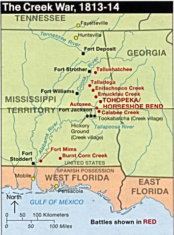
The Creek War (also the Red Stick War or the Creek Civil War) was a regional conflict between opposing Native American factions, European powers, and the United States during the early 19th century. The Creek War began as a conflict within the tribes of the Muscogee, but the United States quickly became involved. British traders and Spanish colonial officials in Florida supplied the Red Sticks with weapons and equipment due to their shared interest in preventing the expansion of the United States into regions under their control. The Creek War took place largely in modern-day Alabama and along the Gulf Coast. Major engagements of the war involved the United States military and the Red Sticks (or Upper Creeks), a Muscogee tribal faction who resisted U.S. territorial expansion. The United States formed an alliance with the traditional enemies of the Muscogee, the Choctaw and Cherokee nations, as well as the Lower Creeks faction of the Muscogee. During the hostilities, the Red ... [...More Info...] [...Related Items...] OR: [Wikipedia] [Google] [Baidu] |
1837 Deaths
Events January–March * January 1 – The destructive Galilee earthquake of 1837, Galilee earthquake causes thousands of deaths in Ottoman Syria. * January 26 – Michigan becomes the 26th state admitted to the United States. * February 4 – Seminoles attack Fort Foster in Florida. * February 25 – In Philadelphia, the Institute for Colored Youth (ICY) is founded, as the first institution for the higher education of black people in the United States. * February – Charles Dickens's ''Oliver Twist'' begins publication in serial form in London. * March 1 – The Congregation of Holy Cross is formed in Le Mans, France, by the signing of the Fundamental Act of Union, which legally joins the Auxiliary Priests of Blessed Basil Moreau, CSC, and the Brothers of St. Joseph (founded by Jacques-François Dujarié) into one religious association. April–June * April 12 – The conglomerate of Procter & Gamble has its origins, when British-born businessmen William Procter and J ... [...More Info...] [...Related Items...] OR: [Wikipedia] [Google] [Baidu] |
1730s Births
Year 173 ( CLXXIII) was a common year starting on Thursday of the Julian calendar. At the time, it was known as the Year of the Consulship of Severus and Pompeianus (or, less frequently, year 926 ''Ab urbe condita''). The denomination 173 for this year has been used since the early medieval period, when the Anno Domini calendar era became the prevalent method in Europe for naming years. Events By place Roman Empire * Gnaeus Claudius Severus and Tiberius Claudius Pompeianus become Roman Consuls. * Given control of the Eastern Empire, Avidius Cassius, the governor of Syria, crushes an insurrection of shepherds known as the Boukoloi. Births * Maximinus Thrax ("the Thracian"), Roman emperor (d. 238) * Mi Heng, Chinese writer and musician (d. 198) Deaths * Donatus of Muenstereifel, Roman soldier and martyr (b. AD 140 Year 140 ( CXL) was a leap year starting on Thursday of the Julian calendar. At the time, it was known as the Year of the Consulship of Hadrianus a ... [...More Info...] [...Related Items...] OR: [Wikipedia] [Google] [Baidu] |
Historical Marker Database
The Historical Marker Database (HMdb.org) is an online database that documents locations of numerous historical markers and commemorative plaques in the United States as well as other countries. The database was launched in 2006 by computer programmer J. J. Prats. The HMdb was launched in 2006 with 179 markers that Prats had personally documented. By 2015 the site listed more than 74,000 markers. In addition to listing markers in the United States, the site also lists some markers from more than 40 other countries. By the start of 2018, the site documented more than 100,000 markers. By the start of 2025, more than 225,000 markers had been documented. The HMdb has been described as " crowdsourced", and according to the site's self-description, "Anyone can add new markers to the database and update existing marker pages with new photographs, links, information and commentary." Dozens of Editors review entries from hundreds of Correspondents before they are accepted into the databa ... [...More Info...] [...Related Items...] OR: [Wikipedia] [Google] [Baidu] |
Chickasaw Nation
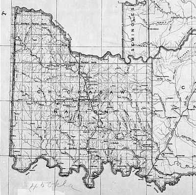
The Chickasaw Nation () is a federally recognized Indigenous nation with headquarters in Ada, Oklahoma, in the United States. The Chickasaw Nation descends from an Indigenous population historically located in the southeastern United States, including present-day northern Mississippi, northwestern Alabama, southwestern Kentucky, and western Tennessee. Today, the Chickasaw Nation is the 12th largest Indigenous nation in the United States, with a population exceeding 80,000 citizens, most of whom reside in Oklahoma. The Chickasaw Nation’s reservation spans approximately 7,648 square miles in south-central Oklahoma. It is divided into four districts: Pontotoc, Pickens, Tishomingo, and Panola, which include counties such as Bryan, Carter, Coal, Garvin, Grady, Jefferson, Johnston, Love, McClain, Marshall, Murray, Pontotoc, and Stephens counties. During the 18th and 19th centuries, several Indigenous nations, including the Chickasaw Nation, were noted for adopting centra ... [...More Info...] [...Related Items...] OR: [Wikipedia] [Google] [Baidu] |
Tishomingo, Oklahoma
Tishomingo is the largest city in, and the county seat of, Johnston County, Oklahoma, United States. The population was 3,101 as of the 2020 census, an increase of 2.2% over the population of 3,034 reported at the 2010 census. It was the first capital of the Chickasaw Nation, from 1856 until Oklahoma statehood in 1907.Maxine Bamburg, "Tishomingo." ''Encyclopedia of Oklahoma History and Culture''. Accessed May 12, 2015 The city is home to Murray State College, a with an annual enrollmen ... [...More Info...] [...Related Items...] OR: [Wikipedia] [Google] [Baidu] |
Tishomingo State Park
Tishomingo State Park is a public recreation area located in the foothills of the Appalachian Mountains in Tishomingo County, Mississippi, Tishomingo County, some northeast of Tupelo, Mississippi, Tupelo, Mississippi. The major feature of the park is Bear Creek Canyon and its generous sandstone outcroppings. Activities in the park include canoeing, rock climbing, fishing, and hiking. The park sits at Milepost 304 of Natchez Trace Parkway, a scenic road operated by the National Park Service that runs directly through the park. Geography The park pays tribute to Tishomingo County, MS, Tishomingo County's remarkable geography of massive rock formations, found here and in the immediately surrounding areas and nowhere else in Mississippi. The cliffs, valleys and abundant outcroppings of carboniferous sandstone and limestone represent the southwestern extremity of the Southern Appalachian Plateau. The boulders and towering cliffs of Hartselle Sandstone, together with the outcrops ... [...More Info...] [...Related Items...] OR: [Wikipedia] [Google] [Baidu] |
Tishomingo, Mississippi
Tishomingo is a town in Tishomingo County, Mississippi, Tishomingo County, Mississippi, United States. The population of the city of Tishomingo was 339 at the 2010 census. History Tishomingo is named for Tishomingo (Chickasaw leader), ''Tishomingo'', who signed the ''Treaty of Pontotoc'' in 1832. He served with Major-General Anthony Wayne against the Shawnees in the Northwest Territory and received a silver medal from President George Washington. During the War of 1812, he served under Andrew Jackson. After his service in the military, he retired to become a farmer until white settlers came onto his land. In 1837, a final treaty forced the Chickasaws to move to the Indian Territory in present-day Oklahoma. Tishomingo died of smallpox on the ''Trail of Tears'' and is buried in Arkansas somewhere near Little Rock, Arkansas, Little Rock.Muriel H. Wright],Official Seals of the Five Civilized Tribes" ''Chronicles of Oklahoma'', Vol. 18, No. 4 (December 1940), pp. 362-363. His son ... [...More Info...] [...Related Items...] OR: [Wikipedia] [Google] [Baidu] |
Lithotomy
Lithotomy from Greek for "lithos" (stone) and "tomos" ( cut), is a surgical method for removal of calculi, stones formed inside certain organs, such as the urinary tract (kidney stones), bladder (bladder stones), and gallbladder (gallstones), that cannot exit naturally through the urinary system or biliary tract. The procedure is usually performed by means of a surgical incision (therefore invasive). Lithotomy differs from lithotripsy, where the stones are crushed either by a minimally invasive probe inserted through the exit canal, or by an acoustic pulse (extracorporeal shock wave lithotripsy), which is a non-invasive procedure. Because of these less invasive procedures, the use of lithotomy has decreased significantly in the modern era. History Ancient history Human beings have known of bladder stones for thousands of years, and have attempted to treat them for almost as long. The oldest bladder stone that has been found was discovered in Egypt in 1901, and it has been ... [...More Info...] [...Related Items...] OR: [Wikipedia] [Google] [Baidu] |
Treaty Of Pontotoc Creek
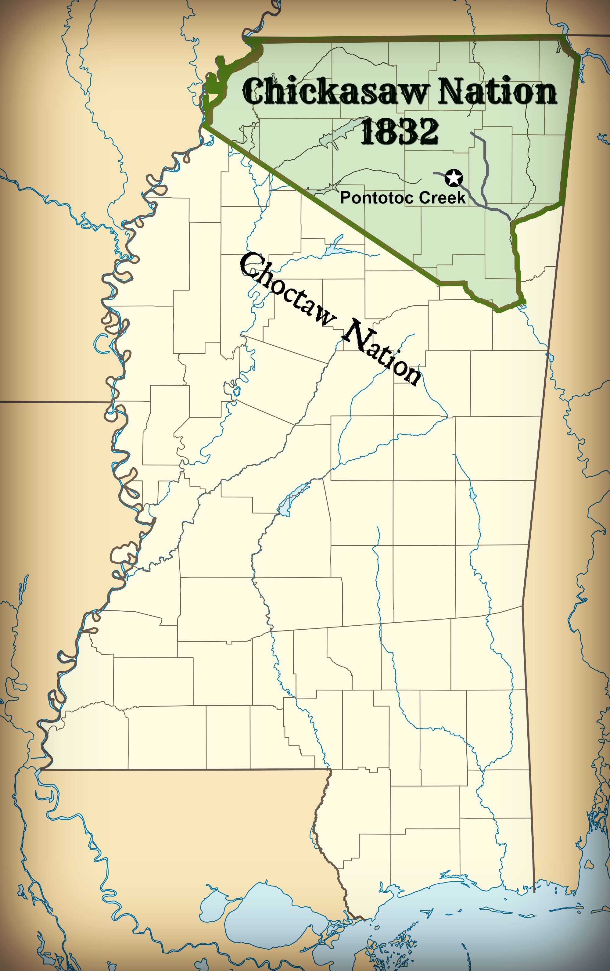
The Treaty of Pontotoc Creek was a treaty signed on October 20, 1832 by representatives of the United States and the Chiefs of the Chickasaw Chickasaw Nation, Nation assembled at the National Council House on Pontotoc Creek in Pontotoc, Mississippi. The treaty ceded the 6,283,804 million acres of the remaining Chickasaw homeland in Mississippi in return for Chickasaw relocation on an equal amount of land west of the Mississippi River. The treaty followed an earlier agreement to move west of the Mississippi in 1830 which the Chickasaw refused to honor after discovering the poor nature of the land they received. Pressured by the aggression of the State of Mississippi to establish its jurisdiction over the Indians, Chickasaw Chiefs relented in 1832 to President Andrew Jackson's and his representatives offer of relocation in the west. The land was ceded to the U.S. with the understanding that the proceeds made in the sale of the land to white settlers would go to the Chickasaw. The tre ... [...More Info...] [...Related Items...] OR: [Wikipedia] [Google] [Baidu] |


