|
Cedynia
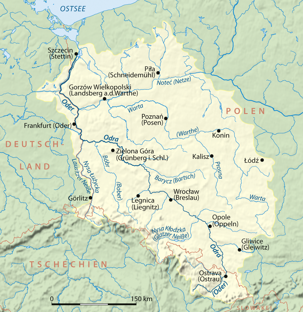
Cedynia (; , ) is a small historic town in Poland, and the administrative seat of Gmina Cedynia in Gryfino County, West Pomeranian Voivodeship. It is situated close to the Oder river and the border with Germany. The town is known for the 972 Battle of Cedynia, the first historically recorded battle of Poland. Geography Cedynia lies in an area that formed part of historic regions of Pomerania and Greater Poland, before later being part of Neumark. It is situated close to the Oder river, which forms the Germany–Poland border; it thereby is the westernmost town in Poland (neighbouring Osinów Dolny lies even further to the west, right on the German border, but is classified as a village). A road border crossing leads to the German town of Bad Freienwalde in the southwest. The town gives its name to an extended protected area known as Cedynia Landscape Park. Demographics Number of inhabitants by year History Largely depopulated during the Migration Period, the first ... [...More Info...] [...Related Items...] OR: [Wikipedia] [Google] [Baidu] |
Battle Of Cedynia
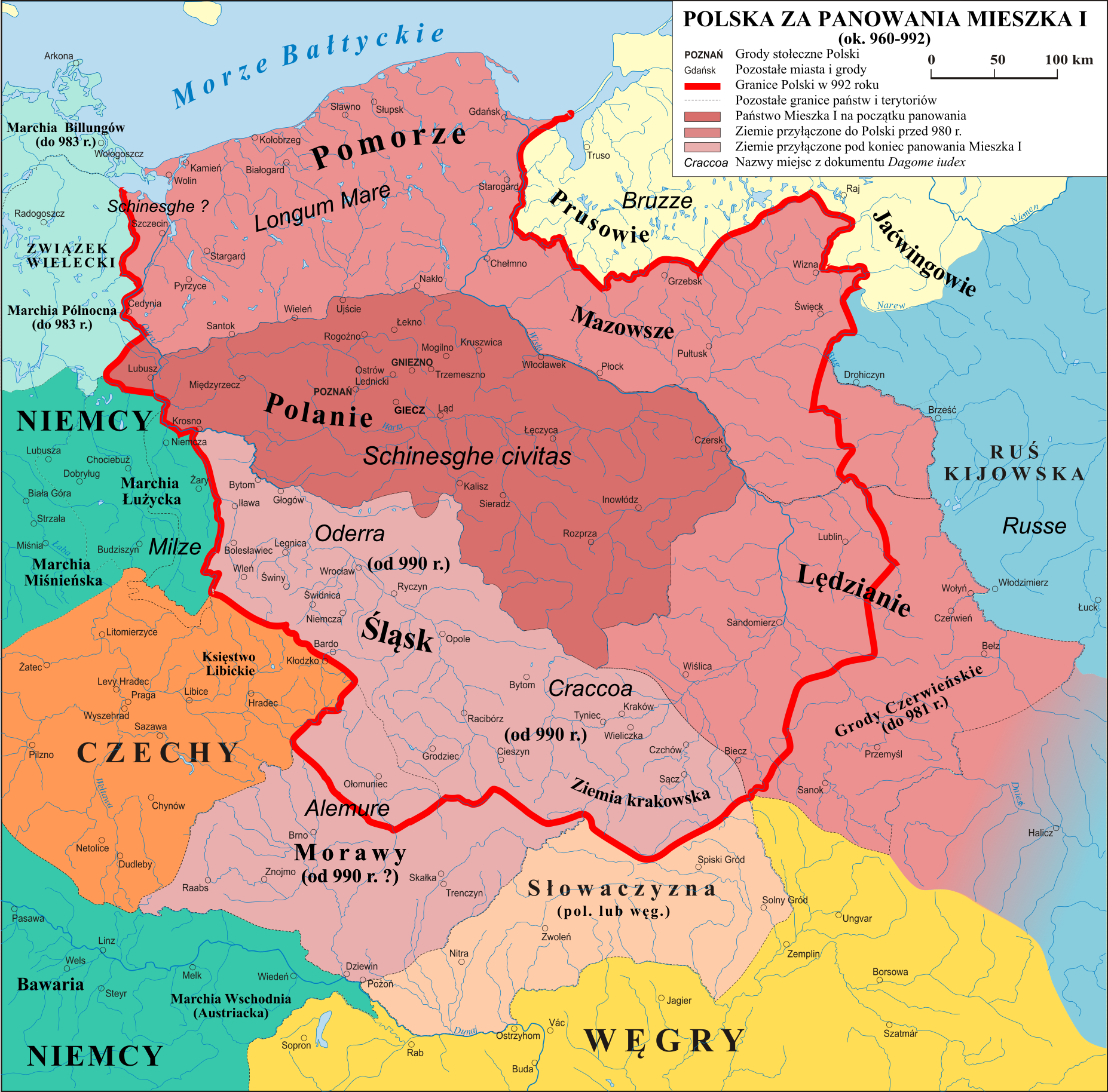
In the Battle of Cedynia or Zehden, an army of Mieszko I of Poland defeated forces of Hodo or Odo I, Margrave of the Saxon Ostmark, Odo I of Lusatia on 24 June 972, near the Oder river. Whether or not the battle actually took place near the modern-day town of Cedynia is disputed in modern scholarship.Gerstenberg (2008), p. 83 Mieszko I, Poland's first documented ruler based in Greater Poland, had successfully campaigned in the Cedynia area, then a West Slavs, West Slavic tribal territory also coveted by Otto I, Holy Roman Emperor, Holy Roman Emperor Otto I and German nobles. While Mieszko's differences with Otto I were settled by an alliance and payment of tribute to the latter, the nobles whom Otto I had invested with the former Saxon Eastern March, most notably Odo I, challenged Mieszko's gains. The battle was to determine the possession of the area between Mieszko and Odo. Records of the battle are sparse, it was briefly described by the chronicler Thietmar of Merseburg (975� ... [...More Info...] [...Related Items...] OR: [Wikipedia] [Google] [Baidu] |
Gmina Cedynia
__NOTOC__ Gmina Cedynia is an urban-rural gmina (administrative district) in Gryfino County, West Pomeranian Voivodeship, in north-western Poland, on the German border. Its seat is the town of Cedynia, which lies approximately south-west of Gryfino and south-west of the regional capital Szczecin. The gmina covers an area of , and as of 2006 its total population is 4,343 (out of which the population of Cedynia amounts to 1,653, and the population of the rural part of the gmina is 2,690). The gmina contains part of the protected area called Cedynia Landscape Park. Villages Apart from the town of Cedynia, Gmina Cedynia contains the villages and settlements of Barcie, Bielinek, Czachów, Golice, Lubiechów Dolny, Lubiechów Górny, Łukowice, Markocin, Niesułów, Orzechów, Osinów Dolny, Parchnica, Piasecznik, Piasek, Radostów, Siekierki, Stara Rudnica, Stary Kostrzynek, Trzypole and Żelichów. Neighbouring gminas Gmina Cedynia is bordered by the gminas of Ch ... [...More Info...] [...Related Items...] OR: [Wikipedia] [Google] [Baidu] |
West Pomeranian Voivodeship
West Pomeranian Voivodeship is a Voivodeships of Poland, voivodeship (province) in northwestern Poland. Its capital and largest city is Szczecin. Its area equals , and in 2021, it was inhabited by 1,682,003 people. It was established on 1 January 1999, out of the former Szczecin Voivodeship (1975–1998), Szczecin and Koszalin Voivodeship (1975–1998), Koszalin Voivodeships and parts of Gorzów Voivodeship, Gorzów, Piła Voivodeship, Piła and Słupsk Voivodeships, pursuant to the Polish local government reforms adopted in 1998. It borders on Pomeranian Voivodeship to the east, Greater Poland Voivodeship to the southeast, Lubusz Voivodeship to the south, the Germany, German States of Germany, federal-states of Mecklenburg-Vorpommern, Mecklenburg-West Pomerania and Brandenburg to the west, and the Baltic Sea to the north.Ustawa z dnia 24 lipca 1998 r. o wprowadzeniu zasadniczego trójstopniowego podziału terytorialnego państwa (Dz.U. z 1998 r. nr 96, poz. 603). Geography and ... [...More Info...] [...Related Items...] OR: [Wikipedia] [Google] [Baidu] |
Gryfino County
__NOTOC__ Gryfino County () is a unit of territorial administration and local government (powiat) in West Pomeranian Voivodeship, north-western Poland, on the German border. It came into being on January 1, 1999, as a result of the Polish local government reforms passed in 1998. Its administrative seat and largest town is Gryfino, which lies south of the regional capital Szczecin. The county contains five other towns: Chojna, south of Gryfino, Mieszkowice, south of Gryfino, Trzcińsko-Zdrój, south of Gryfino, Cedynia, south-west of Gryfino, and Moryń, south of Gryfino. The county covers an area of . As of 2006 its total population is 82,813, out of which the population of Gryfino is 21,478, that of Chojna is 7,187, that of Mieszkowice is 3,553, that of Trzcińsko-Zdrój is 2,496, that of Cedynia is 1,653, that of Moryń is 1,570, and the rural population is 44,876. Neighbouring counties Gryfino County is bordered by Police County and the city of Szczecin to the nort ... [...More Info...] [...Related Items...] OR: [Wikipedia] [Google] [Baidu] |
Cedynia Landscape Park
Cedynia Landscape Park () is a protected area ( Landscape Park) located in north-western Poland, adjacent to the German border. It was established on 1 April 1993, by order of the governor (voivode) of the then Szczecin Voivodeship. The Park covers an area of . It also has a buffer zone (''otulina'') covering . The Park lies within West Pomeranian Voivodeship, in Gryfino County ( Gmina Cedynia, Gmina Chojna, Gmina Mieszkowice and Gmina Moryń). Its buffer zone also includes parts of Gmina Trzcińsko-Zdrój and Gmina Widuchowa). The Park lies on the Polish side of part of the lower stretches of the Oder (Odra) river. The Park's managing authority is called ''Zespół Parków Krajobrazowych Doliny Dolnej Odry'' ("Complex of Landscape Parks of the Lower Odra Valley"). The same authority oversees the Lower Odra Valley Landscape Park, Szczecin Landscape Park and Ujście Warty Landscape Park. Within the Landscape Park are seven nature reserve A nature reserve (also known a ... [...More Info...] [...Related Items...] OR: [Wikipedia] [Google] [Baidu] |
Osinów Dolny
Osinów Dolny () is Poland's westernmost settlement, in the administrative district of Gmina Cedynia, within Gryfino County, West Pomeranian Voivodeship, in north-western Poland, on the border with Germany. It lies approximately south-west of Cedynia, south-west of Gryfino, and south-west of the regional capital Szczecin. The village has a population of 180. It is the site of a border crossing with Hohenwutzen, on the road connecting the Polish town of Chojna with Bad Freienwalde in Germany. History Around 967, the area became part of the emerging Polish state. Following the fragmentation of Poland, it formed part of the Duchy of Greater Poland, and later on, it was also part of Brandenburg, Bohemia (Czechia), Prussia and from 1871 to 1945 also Germany, within which it was administratively located in the Frankfurt Region in the Province of Brandenburg. There used to be a paper mill of minor regional importance in business here from 1936 to 1939. The paper mill was clos ... [...More Info...] [...Related Items...] OR: [Wikipedia] [Google] [Baidu] |
Voivodeship Road
According to classes and categories of public roads in Poland, a voivodeship A voivodeship ( ) or voivodate is the area administered by a voivode (governor) in several countries of central and eastern Europe. Voivodeships have existed since medieval times and the area of extent of voivodeship resembles that of a duchy in ... road () is a category of roads one step below national roads in importance. The roads are numbered from 100 to 993. Total length of voivodeship roads in Poland is of which are unpaved (2008).Transport – activity results in 2008 , Główny Urząd Statystyczny List of voivodeship roads Current list of voivodeship road ...[...More Info...] [...Related Items...] OR: [Wikipedia] [Google] [Baidu] |
Germany–Poland Border
The Germany–Poland border (, ) is the state international border, border between Poland and Germany, mostly along the Oder–Neisse line, with a total length of . (Downloadable pdf file) It stretches from the Baltic Sea in the north to the Czech Republic in the south. History The Germany–Poland border traces its origins to the beginnings of the Polish state, with the Oder (Odra) and Lusatian Neisse (Nysa) rivers (the Oder–Neisse line) being one of the earliest natural boundaries of the early Polish state under the Piast dynasty, although not necessarily yet a border with Germany, as present-day north-eastern Germany was still inhabited by Slavic Lechites, Lechitic tribes, and German conquests and sovereignty over the tribes were periodic and intermittent. Under the first Polish rulers Mieszko I and Bolesław I the Brave, the Polish western border reached further west than the present one, and Poland bordered the German-ruled marches of March of Lusatia, Lusatia and Margrava ... [...More Info...] [...Related Items...] OR: [Wikipedia] [Google] [Baidu] |
Duchy Of Poland (966–1025)
The period of rule by the Piast dynasty between the 10th and 14th centuries is the first major stage of the history of the Polish state. The dynasty was founded by a series of dukes listed by the chronicler Gall Anonymous in the early 12th century: Siemowit, Lestek and Siemomysł. It was Mieszko I, the son of Siemomysł, who is now considered the proper founder of the Polish state at about 960 AD. The ruling house then remained in power in the Polish lands until 1370. Mieszko converted to Christianity of the Western Latin Church in an event known as the Baptism of Poland in 966, which established a major cultural boundary in Europe based on religion. He also completed a unification of the Lechitic tribal lands that was fundamental to the existence of the new country of Poland. Following the emergence of the Polish state, a series of rulers converted the population to Christianity, created a kingdom of Poland in 1025 and integrated Poland into the prevailing culture of Eur ... [...More Info...] [...Related Items...] OR: [Wikipedia] [Google] [Baidu] |
Oder
The Oder ( ; Czech and ) is a river in Central Europe. It is Poland's second-longest river and third-longest within its borders after the Vistula and its largest tributary the Warta. The Oder rises in the Czech Republic and flows through western Poland, later forming of the border between Poland and Germany as part of the Oder–Neisse line. The river ultimately flows into the Szczecin Lagoon north of Szczecin and then into three branches (the Dziwna, Świna and Peene) that empty into the Bay of Pomerania of the Baltic Sea. Names The Oder is known by several names in different languages, but the modern ones are very similar: English and ; Czech, Polish, and , ; (); ; Medieval Latin: ''Od(d)era''; Renaissance Latin: ''Viadrus'' (invented in 1534). The origin of this name is said by onomastician Jürgen Udolph to come from the Illyrian word ''*Adra'' (“water vein”). Ptolemy knew the modern Oder as the Συήβος (''Suebos''; Latin ''Suevus''), a name apparen ... [...More Info...] [...Related Items...] OR: [Wikipedia] [Google] [Baidu] |
History Of Poland During The Piast Dynasty
The period of rule by the Piast dynasty between the 10th and 14th centuries is the first major stage of the history of the Polish state. The dynasty was founded by a series of dukes listed by the chronicler Gall Anonymous in the early 12th century: Siemowit, Lestek and Siemomysł. It was Mieszko I, the son of Siemomysł, who is now considered the proper founder of the Polish state at about 960 AD. The ruling house then remained in power in the Polish lands until 1370. Mieszko converted to Christianity of the Western Latin Church in an event known as the Baptism of Poland in 966, which established a major cultural boundary in Europe based on religion. He also completed a unification of the Lechitic tribal lands that was fundamental to the existence of the new country of Poland. Following the emergence of the Polish state, a series of rulers converted the population to Christianity, created a kingdom of Poland in 1025 and integrated Poland into the prevailing culture of ... [...More Info...] [...Related Items...] OR: [Wikipedia] [Google] [Baidu] |
Bad Freienwalde
Bad Freienwalde is a spa town in the Märkisch-Oderland district in Brandenburg, in north-eastern Germany. Geography The town is situated on the Alte Oder, an old branch of the Oder River at the northwestern rim of the Oderbruch basin and the steep rise of the Barnim Plateau. It is located east of Eberswalde, and northeast of Berlin, near the border with Poland. The municipal area comprises the following villages: Altranft, Altglietzen, Bralitz, Hohensaaten, Hohenwutzen, Neuenhagen and Schiffmühle. History The settlement of ''Vrienwalde'' in the Margraviate of Brandenburg was first mentioned in a 1316 deed and appeared as a town in 1364. From 1618, the Freienwalde manor was directly held by the Brandenburg prince-electors (''Kurfürsten''). From 1701, Bad Freienwalde was part of the Kingdom of Prussia, and from 1871 also the German Empire. From 1815 to 1947, it was administratively part of the Province of Brandenburg. A mineral spring was discovered in 1683. The Alchemy, ... [...More Info...] [...Related Items...] OR: [Wikipedia] [Google] [Baidu] |


