|
Cedar City, UT
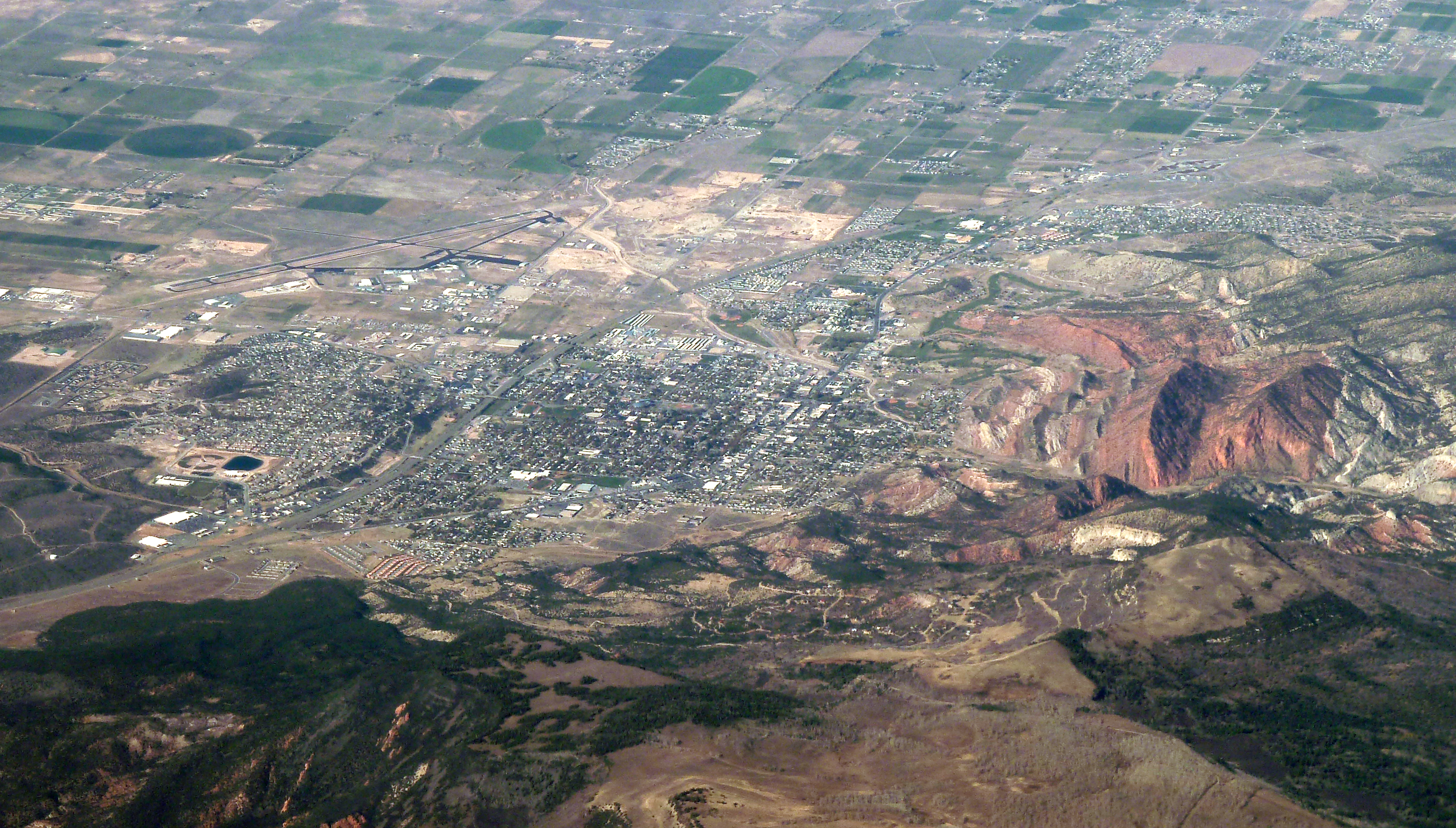
Cedar City is the largest city in Iron County, Utah, United States. Located south of Salt Lake City, it is north of Las Vegas on Interstate 15 in Utah, Interstate 15. Southern Utah University is located in Cedar City. It is the home of the Utah Shakespeare Festival, the Utah Summer Games, the Simon Fest Theatre Co., and other events. As of the 2010 United States Census, 2020 census the city had a population of 35,235, up from 28,857 in the 2010 United States Census, 2010 census. History The presence of prehistoric people in the Cedar City area is revealed by rock art found in Parowan Gap to the north and Fremont culture, Fremont sites dated to A.D. 1000 and 1300. Ancestors of the present-day Southern Paiute people met the Domínguez–Escalante expedition in this area in 1776. Fifty years later, in 1826, mountain man and fur trader Jedediah Smith traveled through the area, exploring a route from Utah to California. Cedar City was originally settled in late 1851 by Mormon pi ... [...More Info...] [...Related Items...] OR: [Wikipedia] [Google] [Baidu] |
City (Utah)
Most U.S. states and territories have at least two tiers of local government: County (United States), counties and municipality, municipalities. Louisiana uses the term List of parishes in Louisiana, parish and Alaska uses the term List of boroughs and census areas in Alaska, borough for what the United States Census Bureau, U.S. Census Bureau terms county equivalents in those states. Civil townships or towns are used as subdivisions of a county in 20 states, mostly in the Northeast and Midwest. Depending on the state, local governments may operate under their own charters or under general law, or a state may have a mix of chartered and general-law local governments. Generally, in a state having both chartered and general-law local governments, the chartered local governments have more local autonomy and home rule. Municipalities are typically subordinate to a county government, with some exceptions. Certain cities, for example, have consolidated with their county government as ... [...More Info...] [...Related Items...] OR: [Wikipedia] [Google] [Baidu] |
Utah Shakespeare Festival
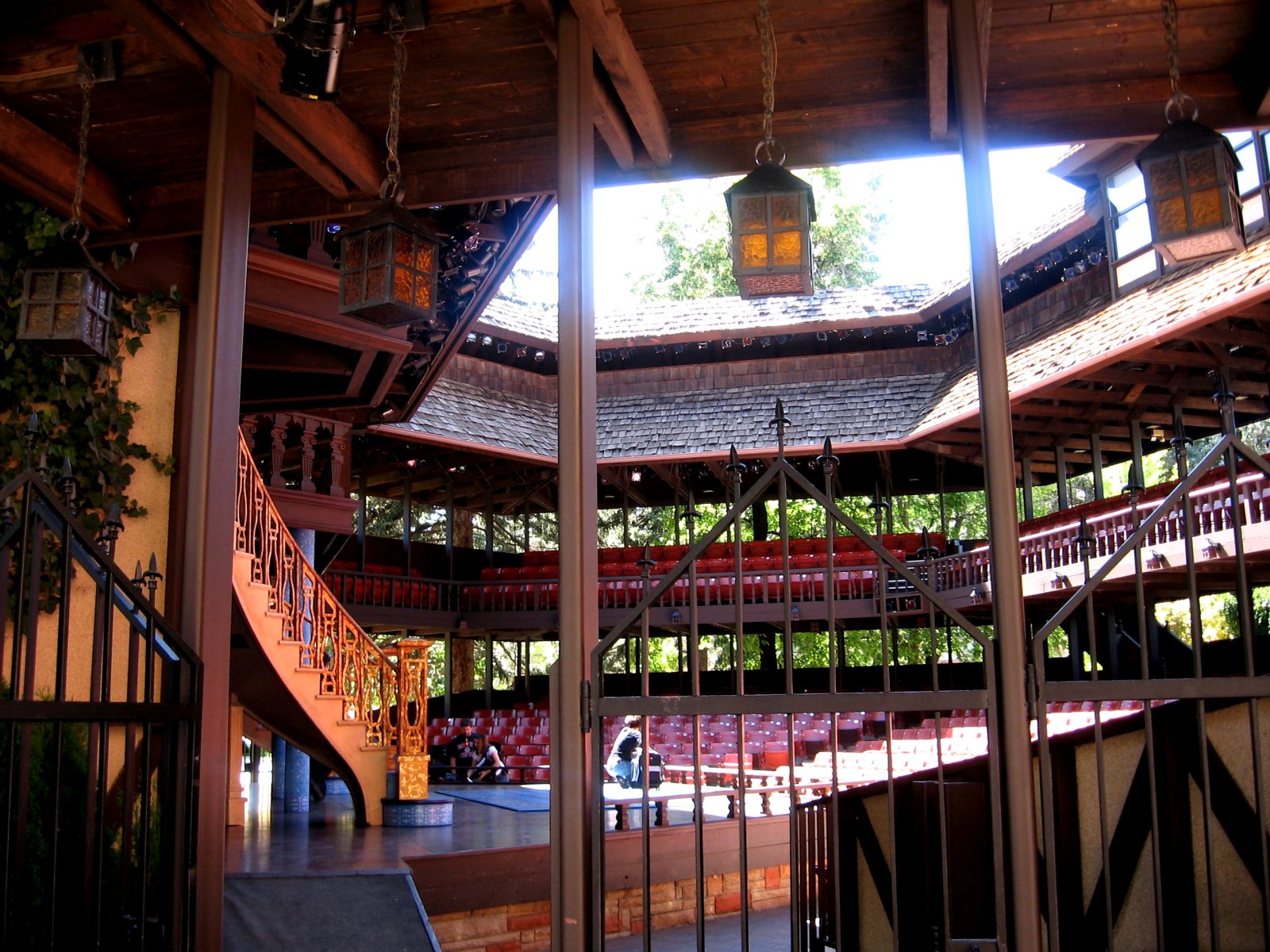
The Utah Shakespeare Festival is a theatrical festival that performs works by Shakespeare as its cornerstone. The Festival is held during the summer and fall on the campus of Southern Utah University in Cedar City, Utah Cedar City is the largest city in Iron County, Utah, United States. Located south of Salt Lake City, it is north of Las Vegas on Interstate 15 in Utah, Interstate 15. Southern Utah University is located in Cedar City. It is the home of the Ut ..., United States. History The Festival was founded in 1961, presented its first season in 1962. Productions During the summer, The Greenshow is performed outdoors before the evening productions. The Greenshow often includes comedic skits, sword fighting, and musical routines with dancing. During and before the performance people dressed (roughly) in period clothing walk around the courtyard (green) selling programs, telling jokes, and offering a variety of treats. Leadership On October 3, 2022 the Festival anno ... [...More Info...] [...Related Items...] OR: [Wikipedia] [Google] [Baidu] |
Iron Works
An ironworks or iron works is a building or site where iron is smelted and where heavy iron and steel products are made. Iron Works may also refer to: * Iron Works, a neighborhood in Brookfield, Connecticut * Clay City, Kentucky, known as Iron Works during the early 19th century * Iron Works, the label that produced Liege Lord {{Dab ... [...More Info...] [...Related Items...] OR: [Wikipedia] [Google] [Baidu] |
Parowan, Utah
Parowan ( ) is a city in and the county seat of Iron County, Utah, United States. The population was 2,790 at the 2010 census, and in 2018 the estimated population was 3,100. Parowan became the first incorporated city in Iron County in 1851. A fort that had been constructed on the east side of Center Creek the previous year was an initial hub in the development of ironworks in the region. Parowan served as the agricultural support base for the local iron industry, whose blast furnace was located in nearby Cedar City. Eventually, the ironworks were decommissioned. Despite occasional successes, the mission failed to produce a consistent and sustained supply of pig iron. By 1858, most of the area's mining operations had ceased due to disappointing yields. Today, the area's chief industries are recreation and tourism. History Fremont culture and Anasazi people were the first known inhabitants of the area where Parowan now exists. Petroglyphs, pithouses, arrowheads, pottery, ... [...More Info...] [...Related Items...] OR: [Wikipedia] [Google] [Baidu] |
Mormon Pioneers
The Mormon pioneers were members of the Church of Jesus Christ of Latter-day Saints (LDS Church), also known as Latter-day Saints, who Human migration, migrated beginning in the mid-1840s until the late-1860s across the United States from the Midwestern United States, Midwest to the Salt Lake Valley in what is today the U.S. state of Utah. At the time of the planning of the exodus in 1846, the territory comprising present-day Utah was part of the History of Mexico#First Republic, Republic of Mexico, with which the U.S. soon went to Mexican–American War, war over a border dispute left unresolved after the Texas annexation, annexation of Texas. The Salt Lake Valley became American territory as a result of the Treaty of Guadalupe Hidalgo, which ended the war. The journey was taken by about 70,000 people, beginning with advance parties sent out by church leaders in March 1846 after the 1844 Death of Joseph Smith, death of the church's leader Joseph Smith made it clear that the gr ... [...More Info...] [...Related Items...] OR: [Wikipedia] [Google] [Baidu] |
California
California () is a U.S. state, state in the Western United States that lies on the West Coast of the United States, Pacific Coast. It borders Oregon to the north, Nevada and Arizona to the east, and shares Mexico–United States border, an international border with the Mexico, Mexican state of Baja California to the south. With almost 40million residents across an area of , it is the List of states and territories of the United States by population, largest state by population and List of U.S. states and territories by area, third-largest by area. Prior to European colonization of the Americas, European colonization, California was one of the most culturally and linguistically diverse areas in pre-Columbian North America. European exploration in the 16th and 17th centuries led to the colonization by the Spanish Empire. The area became a part of Mexico in 1821, following Mexican War of Independence, its successful war for independence, but Mexican Cession, was ceded to the U ... [...More Info...] [...Related Items...] OR: [Wikipedia] [Google] [Baidu] |
Jedediah Smith
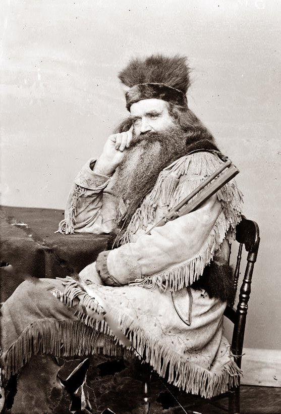
Jedediah Strong Smith (January 6, 1799 – May 27, 1831) was an American clerk, transcontinental pioneer, frontiersman, hunter, trapper, author, cartography, cartographer, mountain man and explorer of the Rocky Mountains, the Western United States, and the Southwestern United States, Southwest during the early 19th century. After 75 years of obscurity following his death, Smith was rediscovered as the American whose explorations led to the use of the -wide South Pass (Wyoming), South Pass as the dominant route across the Continental Divide of the Americas, Continental Divide for pioneers on the Oregon Trail. Coming from modest family background, Smith traveled to St. Louis and joined William Henry Ashley, William H. Ashley and Andrew Henry (fur trader), Andrew Henry's fur trading company in 1822. Smith led the first documented exploration from the Great Salt Lake, Salt Lake frontier to the Colorado River. From there, Smith's party became the first United States citiz ... [...More Info...] [...Related Items...] OR: [Wikipedia] [Google] [Baidu] |
Mountain Man
A mountain man is an Geographical exploration, explorer who lives in the wilderness and makes his living from hunting, fishing and trapping. Mountain men were most common in the North American Rocky Mountains from about 1810 through to the 1880s (with a peak population in the early 1840s). They were instrumental in opening up the various Westward Expansion Trails, emigrant trails (widened into wagon roads) allowing Americans in Eastern United States, the east to settle the new territories of the Western United States, far west by organized wagon trains traveling over roads explored and in many cases, physically improved by the mountain men and the big fur companies, originally to serve the Mule, mule train-based Fur trade, inland fur trade. Mountain men arose in a geographic and economic expansion that was driven by the lucrative earnings available in the North American fur trade, in the wake of the various 1806–1807 published accounts of the Lewis and Clark Expedition findings ... [...More Info...] [...Related Items...] OR: [Wikipedia] [Google] [Baidu] |
Domínguez–Escalante Expedition
The Domínguez–Escalante Expedition was a Spanish journey of exploration conducted in 1776 by two Franciscan priests, Atanasio Domínguez and Silvestre Vélez de Escalante, to find an overland route from Santa Fe, New Mexico, to their Roman Catholic mission in Monterey, on the coast of modern day central California. Domínguez, Vélez de Escalante, and Bernardo de Miera y Pacheco, acting as the expedition's cartographer, traveled with ten men from Santa Fe through many unexplored portions of the American West, including present-day western Colorado, Utah, and northern Arizona. Along part of the journey, they were aided by three indigenous guides of the Timpanogos tribe (Ute people). The land was harsh and unforgiving, and hardships encountered during travel forced the group to return to Santa Fe before reaching Las Californias. Maps and documentation produced by the expedition aided future travelers. The Domínguez–Escalante route eventually became an early template for the ... [...More Info...] [...Related Items...] OR: [Wikipedia] [Google] [Baidu] |
Southern Paiute People
The Southern Paiute people () are a tribe of Native Americans who have lived in the Colorado River basin of southern Nevada, northern Arizona, and southern Utah. Bands of Southern Paiute live in scattered locations throughout this territory and have been granted federal recognition on several reservations. Southern Paiutes traditionally spoke Colorado River Numic, which is now a critically endangered language of the Numic branch of the Uto-Aztecan language family, and is mutually intelligible with Ute. The term Paiute comes from ''paa'' (meaning water in Ute ) and refers to their preference for living near water sources. They practiced springtime, floodplain farming with reservoirs and irrigation ditches for corn, squash, melons, gourds, sunflowers, beans, and wheat. The first European contact with the Southern Paiute occurred in 1776, when fathers Silvestre Vélez de Escalante and Francisco Atanasio Domínguez encountered them during an attempt to find an overland route ... [...More Info...] [...Related Items...] OR: [Wikipedia] [Google] [Baidu] |
Fremont Culture
The Fremont culture or Fremont people is a pre-Columbian archaeological culture which received its name from the Fremont River in the U.S. state of Utah, where the culture's sites were discovered by local indigenous peoples like the Navajo and Ute. In Navajo culture, the pictographs are credited to people who lived before the flood. The Fremont River itself is named for John Charles Frémont, an American explorer. It inhabited sites in what is now Utah and parts of Nevada, Idaho, Wyoming and Colorado from AD 1 to 1301 (2,000–700 years ago). It was adjacent to, roughly contemporaneous with, but distinctly different from the Ancestral Pueblo peoples located to their south. Location Fremont Indian State Park in the Clear Creek Canyon area in Sevier County Utah contains the biggest Fremont culture site in Utah. Thousand-year-old pit houses, petroglyphs, and other Fremont artifacts were discovered at Range Creek, Utah. Nearby Nine Mile Canyon has long been known for its larg ... [...More Info...] [...Related Items...] OR: [Wikipedia] [Google] [Baidu] |
Parowan Gap
Parowan Valley, originally known as the Little Salt Lake Valley, is a basin in Iron County, Utah Utah is a landlocked state in the Mountain states, Mountain West subregion of the Western United States. It is one of the Four Corners states, sharing a border with Arizona, Colorado, and New Mexico. It also borders Wyoming to the northea ..., United States. Description Its lowest point is at in the Little Salt Lake. Fremont Wash, Red Creek, Parowan Creek and other tributaries all drain into the Little Salt Lake. In times that the lake overflows it is drained through the Parowan Gap that passes through the Red Hills into Jackrabbit Wash, in Cedar Valley. See also * List of valleys of Utah References External links Petroglyph day; interpretations and mysteries of Parowan Gap St. George News, June 16, 2019 Valleys of Iron County, Utah Valleys of Utah {{Utah-geo-stub ... [...More Info...] [...Related Items...] OR: [Wikipedia] [Google] [Baidu] |


