|
Castle Rock (Alaskan Island)
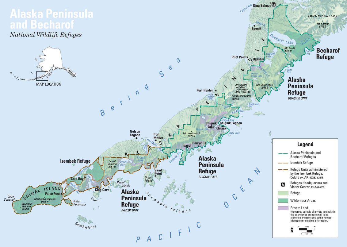
Castle Rock is an island in Alaska in the United States. It is one of the Shumagin Islands. Castle Rock is in Aleutians East Borough, and is located off the south coast of the Alaska Peninsula at 55.27917° North Latitude 159.49944° West Longitude. A ''Barnegat''-class seaplane tender A seaplane tender is a boat or ship that supports the operation of seaplanes. Some of these vessels, known as seaplane carriers, could not only carry seaplanes but also provided all the facilities needed for their operation; these ships are rega ..., the USS ''Castle Rock'' (AVP-35), was named for the island. References Citations External LinksTrails.com Castle Rock USGS Stepovak Bay Quad, Alaska, Topographic Map Shumagin Islands Islands of Alaska Islands of Aleutians East Borough, Alaska {{AleutiansEastAK-geo-stub ... [...More Info...] [...Related Items...] OR: [Wikipedia] [Google] [Baidu] |
Island
An island or isle is a piece of land, distinct from a continent, completely surrounded by water. There are continental islands, which were formed by being split from a continent by plate tectonics, and oceanic islands, which have never been part of a continent. Oceanic islands can be formed from volcano, volcanic activity, grow into atolls from coral reefs, and form from sediment along shorelines, creating barrier islands. River islands can also form from sediment and debris in rivers. Artificial islands are those made by humans, including small rocky outcroppings built out of lagoons and large-scale land reclamation projects used for development. Islands are host to diverse plant and animal life. Oceanic islands have the sea as a natural barrier to the introduction of new species, causing the species that do reach the island to evolve in isolation. Continental islands share animal and plant life with the continent they split from. Depending on how long ago the continental is ... [...More Info...] [...Related Items...] OR: [Wikipedia] [Google] [Baidu] |
Alaska
Alaska ( ) is a non-contiguous U.S. state on the northwest extremity of North America. Part of the Western United States region, it is one of the two non-contiguous U.S. states, alongside Hawaii. Alaska is also considered to be the northernmost, westernmost, and easternmost (the Aleutian Islands cross the 180th meridian into the eastern hemisphere) state in the United States. It borders the Canadian territory of Yukon and the province of British Columbia to the east. It shares a western maritime border, in the Bering Strait, with Russia's Chukotka Autonomous Okrug. The Chukchi and Beaufort Seas of the Arctic Ocean lie to the north, and the Pacific Ocean lies to the south. Technically, it is a semi-exclave of the U.S., and is the largest exclave in the world. Alaska is the largest U.S. state by area, comprising more total area than the following three largest states of Texas, California, and Montana combined, and is the seventh-largest subnational division i ... [...More Info...] [...Related Items...] OR: [Wikipedia] [Google] [Baidu] |
United States
The United States of America (USA), also known as the United States (U.S.) or America, is a country primarily located in North America. It is a federal republic of 50 U.S. state, states and a federal capital district, Washington, D.C. The 48 contiguous states border Canada to the north and Mexico to the south, with the semi-exclave of Alaska in the northwest and the archipelago of Hawaii in the Pacific Ocean. The United States asserts sovereignty over five Territories of the United States, major island territories and United States Minor Outlying Islands, various uninhabited islands in Oceania and the Caribbean. It is a megadiverse country, with the world's List of countries and dependencies by area, third-largest land area and List of countries and dependencies by population, third-largest population, exceeding 340 million. Its three Metropolitan statistical areas by population, largest metropolitan areas are New York metropolitan area, New York, Greater Los Angeles, Los Angel ... [...More Info...] [...Related Items...] OR: [Wikipedia] [Google] [Baidu] |
Shumagin Islands
The Shumagin Islands ( Unangan: ''Qagiiĝun''; ) are a group of 20 islands in the Aleutians East Borough south of the mainland of Alaska, United States, at 54°54'–55°20' North 159°15'–160°45' West. The largest islands are Unga Island, Popof Island, Korovin Island, and Nagai Island. Other islands include Andronica, Big Koniuji, Little Koniuji, Simeonof, Chernabura, and Bird. The total land area is 1,192.369 km2 (460.376 sq mi) and their total population as of the 2020 census was 578 persons, almost entirely in the city of Sand Point, on Popof Island. The Shumagin Islands were named after Nikita Shumagin, one of the sailors on Vitus Bering Vitus Jonassen Bering ( , , ; baptised 5 August 1681 – 19 December 1741),All dates are here given in the Julian calendar, which was in use throughout Russia at the time. also known as Ivan Ivanovich Bering (), was a Danish-born Russia ...'s 1741 expedition to North America who died of scurvy and was buried on ... [...More Info...] [...Related Items...] OR: [Wikipedia] [Google] [Baidu] |
Aleutians East Borough, Alaska
Aleutians East Borough () is a 2nd class borough in the U.S. state of Alaska. As of the 2020 census the borough's population was 3,420. The borough seat is Sand Point. History According to archaeological evidence, the area has been inhabited by the Aleuts since the last ice age. Early contact was with Russian fur traders who sought sea otters in these islands. Whaling, fishing and cannery operations brought an influx of Scandinavian and European fishermen in the early 1900s. During World War II, the area was a strategic military site for the Aleutian Campaign, and many locals were evacuated to Ketchikan. Geography According to the U.S. Census Bureau, the borough has a total area of , of which is land and (53.5%) is water. Aleutians East Borough is located at 57° north latitude and 162° west longitude. It comprises the westernmost portion of the Alaska Peninsula, and a small number of the Aleutian Islands, from which the borough name derives. Also included are ... [...More Info...] [...Related Items...] OR: [Wikipedia] [Google] [Baidu] |
List Of Boroughs And Census Areas In Alaska
A list is a Set (mathematics), set of discrete items of information collected and set forth in some format for utility, entertainment, or other purposes. A list may be memorialized in any number of ways, including existing only in the mind of the list-maker, but lists are frequently written down on paper, or maintained electronically. Lists are "most frequently a tool", and "one does not ''read'' but only ''uses'' a list: one looks up the relevant information in it, but usually does not need to deal with it as a whole".Lucie Doležalová,The Potential and Limitations of Studying Lists, in Lucie Doležalová, ed., ''The Charm of a List: From the Sumerians to Computerised Data Processing'' (2009). Purpose It has been observed that, with a few exceptions, "the scholarship on lists remains fragmented". David Wallechinsky, a co-author of ''The Book of Lists'', described the attraction of lists as being "because we live in an era of overstimulation, especially in terms of information, ... [...More Info...] [...Related Items...] OR: [Wikipedia] [Google] [Baidu] |
Alaska Peninsula
The Alaska Peninsula (also called Aleut Peninsula or Aleutian Peninsula, ; Sugpiaq language, Sugpiaq: ''Aluuwiq'', ''Al'uwiq'') is a peninsula extending about to the southwest from the mainland of Alaska and ending in the Aleutian Islands. The peninsula separates the Pacific Ocean from Bristol Bay, an arm of the Bering Sea. In literature (especially Russian), the term ''Alaska Peninsula'' was used to denote the entire northwestern protrusion of the North American continent, or all of what is now the state of Alaska, exclusive of Alaska Panhandle, its panhandle and list of islands of Alaska, islands. The Lake and Peninsula Borough, Alaska, Lake and Peninsula list of boroughs and census areas in Alaska, borough, the Alaskan equivalent of a county (United States), county, is named after the peninsula. The Alaska/Aleutian Peninsula is also grouped into Southwest Alaska. The other largest peninsulas in Alaska include the Kenai Peninsula and Seward Peninsula. Geography The ba ... [...More Info...] [...Related Items...] OR: [Wikipedia] [Google] [Baidu] |
Latitude
In geography, latitude is a geographic coordinate system, geographic coordinate that specifies the north-south position of a point on the surface of the Earth or another celestial body. Latitude is given as an angle that ranges from −90° at the south pole to 90° at the north pole, with 0° at the Equator. Parallel (latitude), Lines of constant latitude, or ''parallels'', run east-west as circles parallel to the equator. Latitude and longitude are used together as a coordinate pair to specify a location on the surface of the Earth. On its own, the term "latitude" normally refers to the ''geodetic latitude'' as defined below. Briefly, the geodetic latitude of a point is the angle formed between the vector perpendicular (or ''Normal (geometry), normal'') to the ellipsoidal surface from the point, and the equatorial plane, plane of the equator. Background Two levels of abstraction are employed in the definitions of latitude and longitude. In the first step the physical surface i ... [...More Info...] [...Related Items...] OR: [Wikipedia] [Google] [Baidu] |
Longitude
Longitude (, ) is a geographic coordinate that specifies the east- west position of a point on the surface of the Earth, or another celestial body. It is an angular measurement, usually expressed in degrees and denoted by the Greek letter lambda (λ). Meridians are imaginary semicircular lines running from pole to pole that connect points with the same longitude. The prime meridian defines 0° longitude; by convention the International Reference Meridian for the Earth passes near the Royal Observatory in Greenwich, south-east London on the island of Great Britain. Positive longitudes are east of the prime meridian, and negative ones are west. Because of the Earth's rotation, there is a close connection between longitude and time measurement. Scientifically precise local time varies with longitude: a difference of 15° longitude corresponds to a one-hour difference in local time, due to the differing position in relation to the Sun. Comparing local time to an absol ... [...More Info...] [...Related Items...] OR: [Wikipedia] [Google] [Baidu] |
Barnegat Class Seaplane Tender
The ''Barnegat'' class was a large class of United States Navy small seaplane tenders (AVP) built during World War II. Thirty were completed as seaplane tenders, four as motor torpedo boat tenders, and one as a catapult training ship.''Conway's All the World's Fighting Ships 1922–1946'', p. 157 Design Before World War II, the United States Navy foresaw a need for a large force of seaplane tenders in the event of a war in the Pacific, to allow air operations from undeveloped islands and atolls. Full-size seaplane tenders (AVs) were designed to support two squadrons of flying boats each, but they were more expensive to build and had a deep draft, precluding their use in shallow harbors. The U.S. Navy therefore also planned for "small seaplane tenders" (AVPs), with a shallower draft, capable of supporting only one squadron each, but cheaper to build and able to operate in shallow waters. The AVPs were not the descendants of the "seaplane tenders (destroyer)" (AVDs); those had ... [...More Info...] [...Related Items...] OR: [Wikipedia] [Google] [Baidu] |
Seaplane Tender
A seaplane tender is a boat or ship that supports the operation of seaplanes. Some of these vessels, known as seaplane carriers, could not only carry seaplanes but also provided all the facilities needed for their operation; these ships are regarded by some as the first aircraft carriers and appeared just before the First World War. Terminology In maritime parlance a tender is a vessel that is used to support the operation of other vessels. In British usage, the term tender was used for small craft, with the term depot ship being used for large seagoing vessels. Flying boats and float planes even when based at home in ports and harbour had a need for small support vessels to operate.p British tenders were small craft of launch to pinnace size. These were used to ferry crews, stores and supplies between shore and the aircraft, to maintain the buoys used to mark out "taxiways" and "runways" and to keep these clear of debris to prevent foreign object damage, and in the case ... [...More Info...] [...Related Items...] OR: [Wikipedia] [Google] [Baidu] |
USS Castle Rock
USS ''Castle Rock'' (AVP-35) was a United States Navy Barnegat class seaplane tender, ''Barnegat''-class small seaplane tender in commission from 1944 to 1946 which saw service in the late months of World War II. After the war, she was in commission in the United States Coast Guard as the United States Coast Guard Cutter, Coast Guard cutter USCGC ''Castle Rock'' (WAVP-383), later WHEC-383, from 1948 to 1971, seeing service in the Vietnam War during her Coast Guard career. Transferred to South Vietnam in 1971, she served in the Republic of Vietnam Navy as the frigate RVNS ''Trần Bình Trọng'' (HQ-05) and fought in the Battle of the Paracel Islands in 1974. When South Vietnam collapsed at the end of the Vietnam War in 1975, ''Trần Bình Trọng'' fled to the Philippines, where she served in the Philippine Navy from 1979 to 1985 as the frigate RPS (later BRP) ''Francisco Dagohoy'' (PF-10). Construction and commissioning ''Castle Rock'' was Keel-laying, laid down on 12 July 1 ... [...More Info...] [...Related Items...] OR: [Wikipedia] [Google] [Baidu] |


