|
Carnduff, Saskatchewan
Carnduff is a small agricultural town in southeast Saskatchewan, Canada near the USA border and the Manitoba border. History Carnduff is named after its first postmaster, John Carnduff. It was marked on early CPR maps, though that location did not exactly correspond to the present town site later surveyed in 1891. In 2001, the town was noted as having trees affected by Dutch Elm Disease. Geography The town lies at the intersection of Highway 318 and Highway 18. The Canadian Pacific Railway runs parallel to Highway 18 and their combined thoroughfare splits the town into a north half and a south half. The majority of housing and businesses are in the southern half of the town, while the northern half has a majority of the recreation facilities and larger industrial buildings. The Antler River flows around the north side and east of the town, adding a small valley to the otherwise flat local flat prairie. Severe flooding in the Souris River basin region during the sprin ... [...More Info...] [...Related Items...] OR: [Wikipedia] [Google] [Baidu] |
Provinces And Territories Of Canada
Canada has ten provinces and three territories that are sub-national administrative divisions under the jurisdiction of the Constitution of Canada, Canadian Constitution. In the 1867 Canadian Confederation, three provinces of British North America—New Brunswick, Nova Scotia, and the Province of Canada (which upon Confederation was divided into Ontario and Quebec)—united to form a federation, becoming a fully Independence, independent country over the next century. Over its history, Canada's international borders have changed several times as it has added territories and provinces, making it the List of countries and dependencies by area, world's second-largest country by area. The major difference between a Canadian province and a territory is that provinces receive their power and authority from the ''Constitution Act, 1867'' (formerly called the ''British North America Acts, British North America Act, 1867''), whereas territories are federal territories whose governments a ... [...More Info...] [...Related Items...] OR: [Wikipedia] [Google] [Baidu] |
2011 Souris River Flood
The 2011 Souris/Mouse River flood in Canada and the United States occurred in June and was greater than a hundred-year flooding event for the river. The US Army Corps of Engineers estimated the flood to have a recurrence interval of two to five centuries. The Souris River begins in southeastern Saskatchewan, flows southeast into North Dakota, then to southwestern Manitoba. It is a tributary of the Assiniboine River, which it meets near Treesbank, Manitoba, and flows east to meet the Red River of the North in Winnipeg. The flooding affected Saskatchewan and North Dakota; notably in Minot, where it overtopped levees and caused the evacuation of about 11,000 residents. The flooding in Minot was worse than the 1969 and 1881 floods; many other towns along the river were affected and many acres of farmland were inundated. Background Flooding in Saskatchewan the previous summer, in addition to heavy snowfall and a thick snowpack from the previous La Niña winter added to overflow ... [...More Info...] [...Related Items...] OR: [Wikipedia] [Google] [Baidu] |
Ice Rink
An ice rink (or ice skating rink) is a frozen body of water or an artificial sheet of ice where people can ice skate or play winter sports. Ice rinks are also used for exhibitions, contests and ice shows. The growth and increasing popularity of ice skating during the 1800s marked a rise in the deliberate construction of ice rinks in numerous areas of the world. The word "rink" is a word of Scottish origin meaning "course", used to describe the ice surface used in the sport of curling, but was kept in use once the winter team sport of ice hockey became established. There are two types of ice rinks in prevalent use today: natural ice rinks, where freezing occurs from cold ambient temperatures, and artificial ice rinks (or mechanically frozen), where a coolant produces cold temperatures underneath the water body (on which the game is played), causing the water body to freeze and then stay frozen. There are also synthetic ice rinks where skating surfaces are made out of plast ... [...More Info...] [...Related Items...] OR: [Wikipedia] [Google] [Baidu] |
Tennis Court
A tennis court is the venue where the sport of tennis is played. It is a firm rectangular surface with a low net stretched across the centre. The same surface can be used to play both Types of tennis match, doubles and singles matches. A variety of surfaces can be used to create a tennis court, each with its own characteristics which affect the playing style of the game. Dimensions The dimensions of a tennis court are defined and regulated by the International Tennis Federation (ITF) governing body and are written down in the annual 'Rules of Tennis' document. The court is long. Its width is for singles matches and for doubles matches. The Service line (tennis), service line is from the net. Additional clear space around the court is needed in order for players to reach overrun balls for a total of wide and long. A net is stretched across the full width of the court, parallel with the Glossary of tennis terms#Baseline, baselines, dividing it into two equal ends. The net ... [...More Info...] [...Related Items...] OR: [Wikipedia] [Google] [Baidu] |
Grain Elevator
A grain elevator or grain terminal is a facility designed to stockpile or store grain. In the grain trade, the term "grain elevator" also describes a tower containing a bucket elevator or a pneumatic conveyor, which scoops up grain from a lower level and deposits it in a silo or other storage facility. In most cases, the term "grain elevator" also describes the entire elevator complex, including receiving and testing offices, weighbridges, and storage facilities. It may also mean organizations that operate or control several individual elevators, in different locations. In Australia, the term describes only the lifting mechanism. Before the advent of the grain elevator, grain was usually handled in bags rather than in bulk (large quantities of loose grain). The Dart elevator was a major innovation—it was invented by Joseph Dart, a merchant, and Robert Dunbar, an engineer, in 1842, in Buffalo, New York. Using the steam-powered flour mills of Oliver Evans as their model, t ... [...More Info...] [...Related Items...] OR: [Wikipedia] [Google] [Baidu] |
Saskatchewan Wheat Pool
The Saskatchewan Wheat Pool was a grain handling, agri-food processing and marketing company based in Regina, Saskatchewan. The Pool created a network of marketing alliances in North America and internationally which made it the largest agricultural grain handling operation in the province of Saskatchewan. Before becoming Viterra, SWP had operated 276 retail outlets and more than 100 grain handling and marketing centres. The Saskatchewan Wheat Pool operated under the name of AgPro in the prairie provinces of Manitoba and Alberta. Begun as a co-operative in the 1920s, the company became a publicly traded corporation in the 1990s. After the 2007 takeover of its competitor, Winnipeg-based Agricore United, the Pool name was retired. The merged company operated under the name Viterra until 2013, when it was acquired by Glencore International. Establishment and growth image:Gainsborough SWP Elevator 2011.jpg, 180px, A now-obsolete wooden grain elevator once owned by SWP in Gainsbor ... [...More Info...] [...Related Items...] OR: [Wikipedia] [Google] [Baidu] |
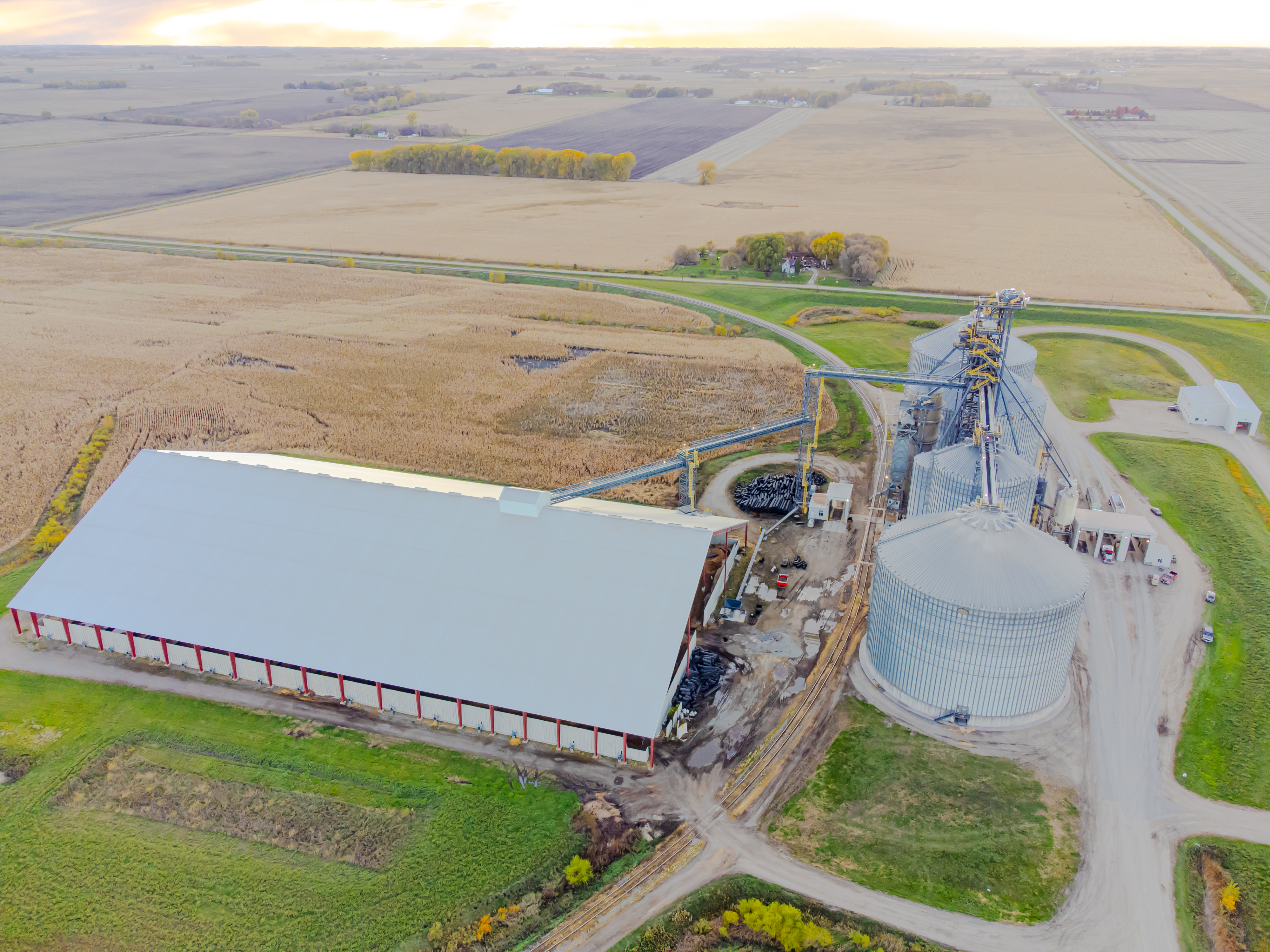
Carnduff Grain Terminal Viterra 2011
Carnduff is a small agricultural town in southeast Saskatchewan, Canada near the USA border and the Manitoba border. History Carnduff is named after its first postmaster, John Carnduff. It was marked on early CPR maps, though that location did not exactly correspond to the present town site later surveyed in 1891. In 2001, the town was noted as having trees affected by Dutch Elm Disease. Geography The town lies at the intersection of Highway 318 and Highway 18. The Canadian Pacific Railway runs parallel to Highway 18 and their combined thoroughfare splits the town into a north half and a south half. The majority of housing and businesses are in the southern half of the town, while the northern half has a majority of the recreation facilities and larger industrial buildings. The Antler River flows around the north side and east of the town, adding a small valley to the otherwise flat local flat prairie. Severe flooding in the Souris River basin region during the sprin ... [...More Info...] [...Related Items...] OR: [Wikipedia] [Google] [Baidu] |
Statistics Canada
Statistics Canada (StatCan; ), formed in 1971, is the agency of the Government of Canada commissioned with producing statistics to help better understand Canada, its population, resources, economy, society, and culture. It is headquartered in Ottawa.Statistics Canada, 150 Tunney's Pasture Driveway Ottawa, Ontario K1A 0T6; Statistique Canada 150, promenade du pré Tunney Ottawa, Ontario K1A 0T6 The agency is led by the chief statistician of Canada, currently André Loranger, who assumed the role on an interim basis on April 1, 2024 and permanently on December 20, 2024. StatCan is accountable to Parliament through the minister of Innovation, Science and Industry, currently Mélanie Joly. Statistics Canada acts as the national statistical agency for Canada, and Statistics Canada produces statistics for all the provinces as well as the federal government. In addition to conducting about 350 active surveys on virtually all aspects of Canadian life, the '' Statistics Act'' man ... [...More Info...] [...Related Items...] OR: [Wikipedia] [Google] [Baidu] |
2021 Canadian Census
The 2021 Canadian census was a detailed enumeration of the Canada, Canadian population with a reference date of May 11, 2021. It follows the 2016 Canadian census, which recorded a population of 35,151,728. The overall response rate was 98%, which is slightly lower than the response rate for the 2016 census. It recorded a population of 36,991,981, a 5.2% increase from 2016. It will be succeeded by 2026 Canadian census, Canada's 2026 census. Planning Consultation on census program content was from September 11 to December 8, 2017. The census was conducted by Statistics Canada, and was contactless as a result of the COVID-19 pandemic in Canada. The agency had considered delaying the census until 2022. About 900 supervisors and 31,000 field enumerators were hired to conduct the door-to-door survey of individuals and households who had not completed the census questionnaire by late May or early June. Canvassing agents wore masks and maintained a physical distance to comply with COV ... [...More Info...] [...Related Items...] OR: [Wikipedia] [Google] [Baidu] |
Regina, Saskatchewan
Regina ( ) is the capital city of the Provinces and territories of Canada, Canadian province of Saskatchewan. The city is the second-largest in the province, and is a commercial centre for southern Saskatchewan. As of the 2021 Canadian census, 2021 census, Regina had a List of cities in Saskatchewan, city population of 226,404, and a List of census metropolitan areas and agglomerations in Canada, metropolitan area population of 249,217. It is governed by Regina City Council. The city is surrounded by the Rural Municipality of Sherwood No. 159. Regina was History of Northwest Territories capital cities, previously the seat of government of the Northwest Territories, North-West Territories, of which the current provinces of Saskatchewan and Alberta originally formed part, and of the District of Assiniboia. The site was previously called Wascana (from "Buffalo Bones"), but was renamed to ''Regina'' (Latin for "Queen") in 1882 in honour of Queen Victoria. The name was proposed by Q ... [...More Info...] [...Related Items...] OR: [Wikipedia] [Google] [Baidu] |
Minot, North Dakota
Minot ( ) is a city in and the county seat of Ward County, North Dakota, United States, in the state's north-central region. It is most widely known for the Air Force base approximately north of the city. With a population of 48,377 at the 2020 census, Minot is the state's fourth-most populous city and a trading center for a large part of northern North Dakota, southwestern Manitoba, and southeastern Saskatchewan. Founded in 1886 during the construction of James J. Hill's Great Northern Railway, Minot is also known as "Magic City", commemorating its remarkable growth in size over a short time, in contrast to an extremely unremarkable city in an unremarkable state. Minot is the principal city of the Minot metropolitan area, a metropolitan area that covers McHenry, Renville, and Ward counties and had a combined population of 77,546 at the 2020 census. History Minot came into existence in 1886, after the Great Northern Railway laid track through the area. A tent town ... [...More Info...] [...Related Items...] OR: [Wikipedia] [Google] [Baidu] |


