|
California River
California River is the name of a northeastward flowing river system that existed in the Cretaceous-Eocene in the western United States. It is so named because it flowed from the Mojave region of California to the Uinta Basin of Utah, transporting sediments along this track towards Lake Uinta. Course The river originated in the North American Cordillera of California in the Mojave/ Alisitos arc, between the Nevadaplano farther north and the Mexicoplano farther south. It then flowed east-northeastward between the Sevier fold-and-thrust belt to the north and the Maria fold-and-thrust belt to the south. It continued northeastward between the Kaibab and the Circle Cliffs uplift and eventually turned due north between the Uncompahgre and San Rafael swells. The course of the river extended over . Ancestral Little Colorado River was a tributary, and the ancestral Mogollon Highlands also drained in this river system. The river ended in the Uinta Basin and Lake Uinta in present- ... [...More Info...] [...Related Items...] OR: [Wikipedia] [Google] [Baidu] |
Cretaceous
The Cretaceous ( ) is a geological period that lasted from about 145 to 66 million years ago (Mya). It is the third and final period of the Mesozoic Era, as well as the longest. At around 79 million years, it is the longest geological period of the entire Phanerozoic. The name is derived from the Latin ''creta'', " chalk", which is abundant in the latter half of the period. It is usually abbreviated K, for its German translation ''Kreide''. The Cretaceous was a period with a relatively warm climate, resulting in high eustatic sea levels that created numerous shallow inland seas. These oceans and seas were populated with now-extinct marine reptiles, ammonites, and rudists, while dinosaurs continued to dominate on land. The world was ice free, and forests extended to the poles. During this time, new groups of mammals and birds appeared. During the Early Cretaceous, flowering plants appeared and began to rapidly diversify, becoming the dominant group of plants across the Ear ... [...More Info...] [...Related Items...] OR: [Wikipedia] [Google] [Baidu] |
River Delta
A river delta is a landform shaped like a triangle, created by deposition of sediment that is carried by a river and enters slower-moving or stagnant water. This occurs where a river enters an ocean, sea, estuary, lake, reservoir, or (more rarely) another river that cannot carry away the supplied sediment. It is so named because its triangle shape resembles the Greek letter Delta. The size and shape of a delta is controlled by the balance between watershed processes that supply sediment, and receiving basin processes that redistribute, sequester, and export that sediment. The size, geometry, and location of the receiving basin also plays an important role in delta evolution. River deltas are important in human civilization, as they are major agricultural production centers and population centers. They can provide coastline defense and can impact drinking water supply. They are also ecologically important, with different species' assemblages depending on their landscape posi ... [...More Info...] [...Related Items...] OR: [Wikipedia] [Google] [Baidu] |
Terminal Lake
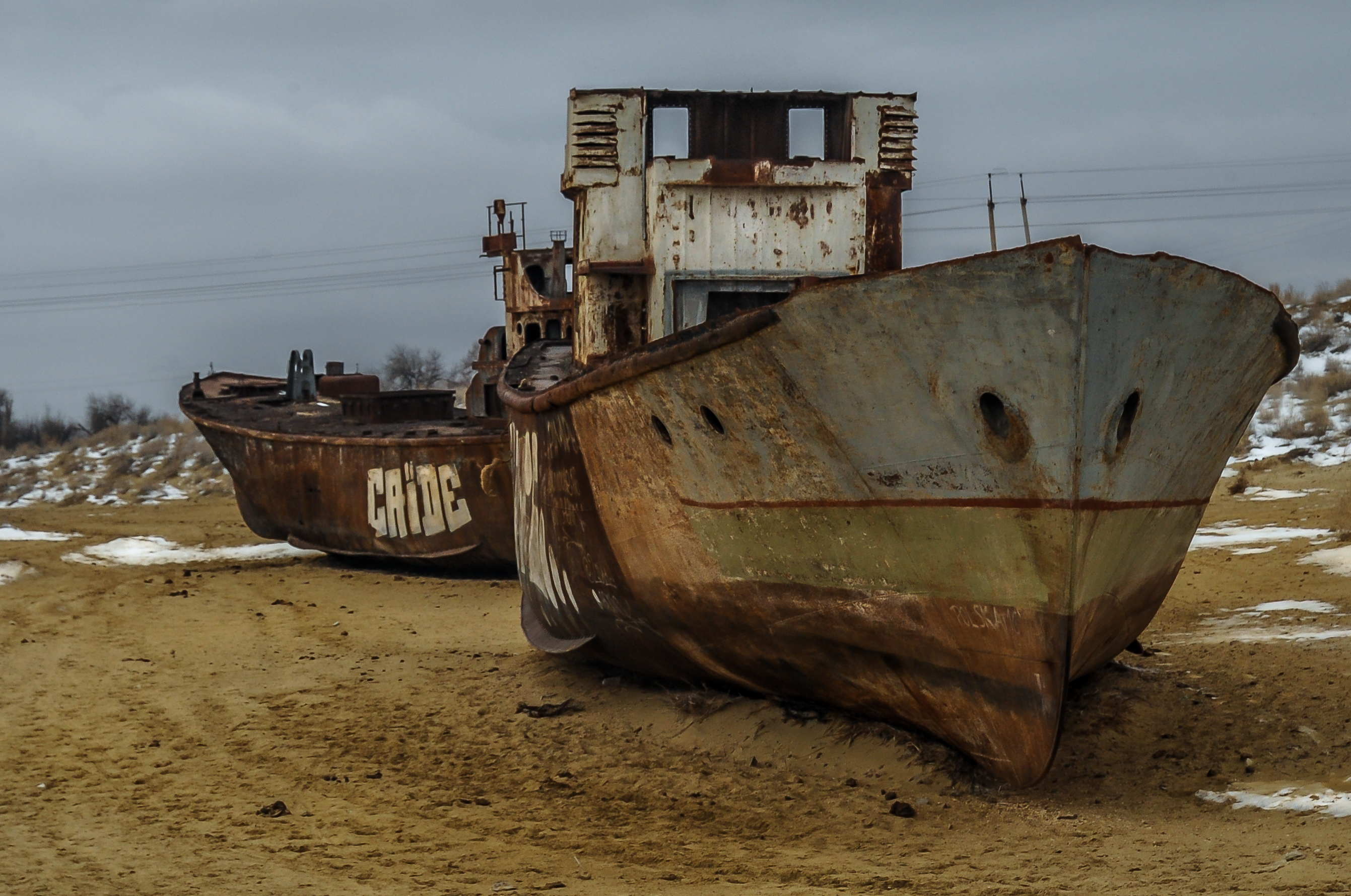
An endorheic lake (also called a sink lake or terminal lake) is a collection of water within an endorheic basin, or sink, with no evident outlet. Endorheic lakes are generally saline as a result of being unable to get rid of solutes left in the lake by evaporation. These lakes can be used as indicators of anthropogenic change, such as irrigation or climate change, in the areas surrounding them. Lakes with subsurface drainage are considered cryptorheic. Components of endorheic lakes The two main ways that endorheic lakes accumulate water are through river flow into the lake (discharge) and precipitation falling into the lake. The collected water of the lake, instead of discharging, can only be lost due to either evapotranspiration or percolation (water sinking underground, e.g., to become groundwater in an aquifer). Because of this lack of an outlet, endorheic lakes are mostly salt water rather than fresh water. The salinity in the lake gradually builds up through years as wate ... [...More Info...] [...Related Items...] OR: [Wikipedia] [Google] [Baidu] |
Ili River
The Ili ( ug, ئىلى دەرياسى, Ili deryasi, Ili dəryasi, 6=Или Дәряси; kk, Ile, ; russian: Или; zh, c=伊犁河, p=Yīlí Hé, dng, Йили хә, Xiao'erjing: اِلِ حْ; mn, Ил, literally "Bareness") is a river situated in Northwest China and Southeastern Kazakhstan. It flows from the Ili Kazakh Autonomous Prefecture of the Xinjiang Uighur Autonomous Region to the Almaty Region in Kazakhstan. It is long (including its source river Tekes),Или of which is in Kazakhstan. The river originates from the Tekes and Künes rivers in Eastern [...More Info...] [...Related Items...] OR: [Wikipedia] [Google] [Baidu] |
Colorado River
The Colorado River ( es, Río Colorado) is one of the principal rivers (along with the Rio Grande) in the Southwestern United States and northern Mexico. The river drains an expansive, arid watershed that encompasses parts of seven U.S. states and two Mexican states. The name Colorado derives from the Spanish language for "colored reddish" due to its heavy silt load. Starting in the central Rocky Mountains of Colorado, it flows generally southwest across the Colorado Plateau and through the Grand Canyon before reaching Lake Mead on the Arizona–Nevada border, where it turns south toward the international border. After entering Mexico, the Colorado approaches the mostly dry Colorado River Delta at the tip of the Gulf of California between Baja California and Sonora. Known for its dramatic canyons, whitewater rapids, and eleven U.S. National Parks, the Colorado River and its tributaries are a vital source of water for 40 million people. An extensive system of dams ... [...More Info...] [...Related Items...] OR: [Wikipedia] [Google] [Baidu] |
Piceance Creek Basin
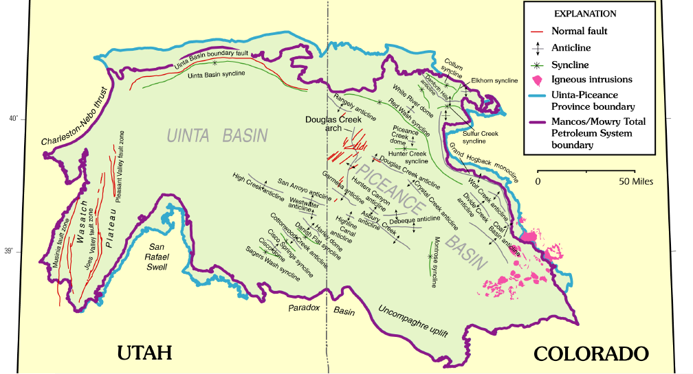
The Piceance Basin is a geologic structural basin in northwestern Colorado, in the United States. It includes geologic formations from Cambrian to Holocene in age, but the thickest section is made up of rocks from the Cretaceous Period. The basin contains reserves of coal, natural gas, and oil shale. The name likely derives from the Shoshoni word ''/piasonittsi/'' meaning “tall grass” (''/pia-/'' ‘big’ and ''/soni-/'' ‘grass’). Hydrocarbon resources In 2016 USGS released an assessment of the resources of the Mancos Shale of the Piceance Basin in Colorado and Utah, "a total of assessed technically recoverable mean resources of 74 million barrels of shale oil, 66.3 trillion cubic feet of gas, and 45 million barrels of natural gas liquids." Natural gas The basin has come to increasing public attention in recent years because of widespread drilling to extract natural gas. The primary target of gas development has been the Williams Fork Formation of the Mesaverde Group ... [...More Info...] [...Related Items...] OR: [Wikipedia] [Google] [Baidu] |
San Juan Basin
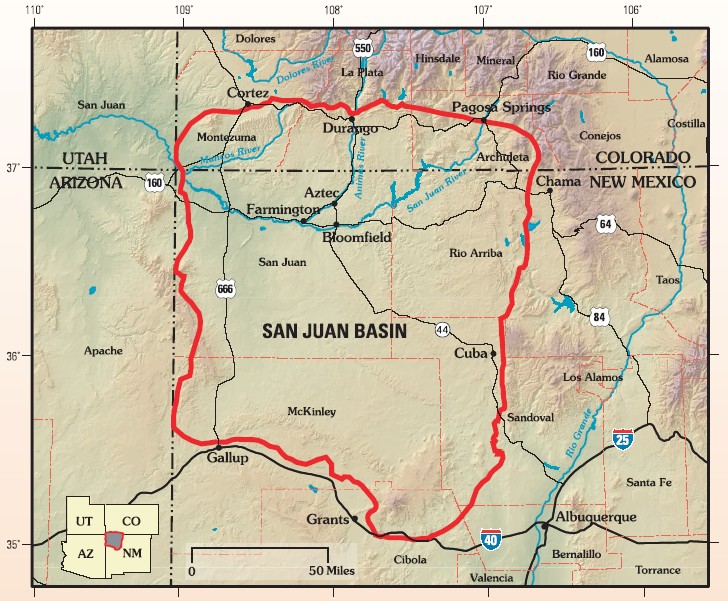
The San Juan Basin is a geologic structural basin located near the Four Corners region of the Southwestern United States. The basin covers 7,500 square miles and resides in northwestern New Mexico, southwestern Colorado, and parts of Utah and Arizona. Specifically, the basin occupies space in the San Juan, Rio Arriba, Sandoval, and McKinley counties in New Mexico, and La Plata and Archuleta counties in Colorado. The basin extends roughly N-S and E-W. The San Juan Basin is an asymmetric structural depression in the Colorado Plateau province, with varying elevation and nearly in topographic relief. Its most striking features include Chaco Canyon (northwestern New Mexico, between Farmington and Santa Fe) and Chacra Mesa. The basin lies west of the Continental Divide, and its main drainage is the southwest- to west-flowing San Juan River, which eventually joins the Colorado River in Utah. Climate of the basin is arid to semiarid, with an annual precipitation of and an ... [...More Info...] [...Related Items...] OR: [Wikipedia] [Google] [Baidu] |
Arctic Ocean
The Arctic Ocean is the smallest and shallowest of the world's five major oceans. It spans an area of approximately and is known as the coldest of all the oceans. The International Hydrographic Organization (IHO) recognizes it as an ocean, although some oceanographers call it the Arctic Mediterranean Sea. It has been described approximately as an estuary of the Atlantic Ocean. It is also seen as the northernmost part of the all-encompassing World Ocean. The Arctic Ocean includes the North Pole region in the middle of the Northern Hemisphere and extends south to about 60°N. The Arctic Ocean is surrounded by Eurasia and North America, and the borders follow topographic features: the Bering Strait on the Pacific side and the Greenland Scotland Ridge on the Atlantic side. It is mostly covered by sea ice throughout the year and almost completely in winter. The Arctic Ocean's surface temperature and salinity vary seasonally as the ice cover melts and freezes; its salinit ... [...More Info...] [...Related Items...] OR: [Wikipedia] [Google] [Baidu] |
Platte River
The Platte River () is a major river in the State of Nebraska. It is about long; measured to its farthest source via its tributary, the North Platte River, it flows for over . The Platte River is a tributary of the Missouri River, which itself is a tributary of the Mississippi River which flows to the Gulf of Mexico. The Platte over most of its length is a broad, shallow, meandering stream with a sandy bottom and many islands—a braided stream. The Platte is one of the most significant tributary systems in the watershed of the Missouri, draining a large portion of the central Great Plains in Nebraska and the eastern Rocky Mountains in Colorado and Wyoming. The river valley played an important role in the westward expansion of the United States, providing the route for several major emigrant trails, including the Oregon, California, Mormon and Bozeman trails. The first Europeans to see the Platte were French explorers and fur trappers about 1714; they first called it the ' ... [...More Info...] [...Related Items...] OR: [Wikipedia] [Google] [Baidu] |
Colton Formation
The Colton Formation is a geologic formation in Utah. Its age is based on its position between the Upper Cretaceous-Paleocene North Horn Formation and overlying Green River Formation. The name was first used by P.T. Walton in 1944 for strata below the Green River Formation at the base of the Roan Cliffs, Utah. However, the type section was first given by E.M. Spieker in 1946. for exposures near the town of Colton on Soldier Summit, Utah County, Utah. Previously, the strata were assigned to the Wasatch Formation, which had become a rather generic name by the US Geological Survey for mudstone-sandstone strata of Eocene age. The formation is composed of reddish-brown to green beds of mudstone and shaly siltstone, interlayered with yellowish- to grayish-orange and grayish-brown, thin, fine- to medium-grained quartzose sandstone beds. The mudstones are locally variegated in shades of red and gray. Many sandstones are cross-bedded in large and small trough sets and the thicker samdsto ... [...More Info...] [...Related Items...] OR: [Wikipedia] [Google] [Baidu] |
Green River (Colorado River Tributary)
The Green River, located in the western United States, is the chief tributary of the Colorado River. The watershed of the river, known as the Green River Basin, covers parts of the U.S. states of Wyoming, Utah, and Colorado. The Green River is long, beginning in the Wind River Mountains of Wyoming and flowing through Wyoming and Utah for most of its course, except for a short segment of in western Colorado. Much of the route traverses the arid Colorado Plateau, where the river has carved some of the most spectacular canyons in the United States. The Green is slightly smaller than Colorado when the two rivers merge but typically carries a larger load of silt. The average yearly mean flow of the river at Green River, Utah is per second. The status of the Green River as a tributary of the Colorado River came about mainly for political reasons. In earlier nomenclature, the Colorado River began at its confluence with the Green River. Above the confluence, Colorado was called the ... [...More Info...] [...Related Items...] OR: [Wikipedia] [Google] [Baidu] |
Utah
Utah ( , ) is a state in the Mountain West subregion of the Western United States. Utah is a landlocked U.S. state bordered to its east by Colorado, to its northeast by Wyoming, to its north by Idaho, to its south by Arizona, and to its west by Nevada. Utah also touches a corner of New Mexico in the southeast. Of the fifty U.S. states, Utah is the 13th-largest by area; with a population over three million, it is the 30th-most-populous and 11th-least-densely populated. Urban development is mostly concentrated in two areas: the Wasatch Front in the north-central part of the state, which is home to roughly two-thirds of the population and includes the capital city, Salt Lake City; and Washington County in the southwest, with more than 180,000 residents. Most of the western half of Utah lies in the Great Basin. Utah has been inhabited for thousands of years by various indigenous groups such as the ancient Puebloans, Navajo and Ute. The Spanish were the first Europ ... [...More Info...] [...Related Items...] OR: [Wikipedia] [Google] [Baidu] |


