|
Buckland Monachorum
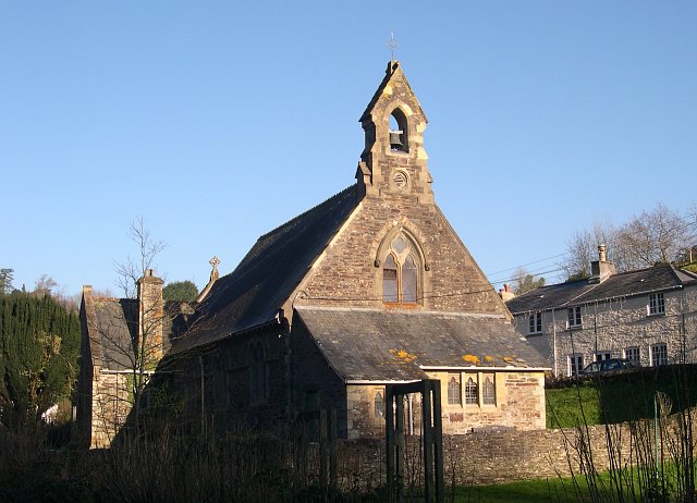
Buckland Monachorum is a village and civil parish in the West Devon district of Devon, England, situated on the River Tavy, about 10 miles north of Plymouth. In 2006 the neighbourhood had an estimated 1,511 residents and 654 dwellings. The electoral ward of the same name gave a population of 3,380 at the 2011 census. At the 2011 United Kingdom census the civil parish had a population of 3,763. Domesday Book (1086) records Buckland Monachorum (''Bocheland'') as having 46 households, land for 15 ploughs, a salt pan and a fishery. It was in the possession of William de Poilley, one of 17 estates he held in southern Devon as a tenant-in-chief of William the Conqueror. Near to Buckland Monachorum is Buckland Abbey, home of Sir Francis Drake during the Elizabethan era. The village is the site of St Andrew's, a 12th-century church with a Saxon baptismal font and the tombs of the Drake family and Lord Heathfield, the defender of Gibraltar, many historic buildings, and a complex of in ... [...More Info...] [...Related Items...] OR: [Wikipedia] [Google] [Baidu] |
Civil Parish
In England, a civil parish is a type of administrative parish used for local government. It is a territorial designation which is the lowest tier of local government. Civil parishes can trace their origin to the ancient system of parishes, which for centuries were the principal unit of secular and religious administration in most of England and Wales. Civil and religious parishes were formally split into two types in the 19th century and are now entirely separate. Civil parishes in their modern form came into being through the Local Government Act 1894 ( 56 & 57 Vict. c. 73), which established elected parish councils to take on the secular functions of the parish vestry. A civil parish can range in size from a sparsely populated rural area with fewer than a hundred inhabitants, to a large town with a population in excess of 100,000. This scope is similar to that of municipalities in continental Europe, such as the communes of France. However, unlike their continental Euro ... [...More Info...] [...Related Items...] OR: [Wikipedia] [Google] [Baidu] |
Anglo-Saxons
The Anglo-Saxons, in some contexts simply called Saxons or the English, were a Cultural identity, cultural group who spoke Old English and inhabited much of what is now England and south-eastern Scotland in the Early Middle Ages. They traced their origins to Germanic peoples, Germanic settlers who became one of the most important cultural groups in Britain by the 5th century. The Anglo-Saxon period in Britain is considered to have started by about 450 and ended in 1066, with the Norman conquest of England, Norman Conquest. Although the details of Anglo-Saxon settlement of Britain, their early settlement and History of Anglo-Saxon England, political development are not clear, by the 8th century an Anglo-Saxon cultural identity which was generally called had developed out of the interaction of these settlers with the existing Romano-British culture. By 1066, most of the people of what is now England spoke Old English, and were considered English. Viking and Norman invasions chang ... [...More Info...] [...Related Items...] OR: [Wikipedia] [Google] [Baidu] |
Sam Lakeman
Samuel Charles Lakeman (born 6 November 1975) is an English musician, songwriter, and producer and co-owner of Charcoal Records. Lakeman was brought up in the village of Buckland Monachorum, near Yelverton, Devon, Yelverton, Devon, United Kingdom, with his brothers, fellow musicians Seth Lakeman and Sean Lakeman. He currently lives in Frome, Somerset, UK, with his wife, the award-winning Northern Irish singer Cara Dillon, and their three children. Career Sam began playing music with his parents and two brothers Seth Lakeman, Seth and Sean Lakeman, Sean at an early age. As a family band they started playing at festivals, and small concerts. Lakeman and his siblings formed The Lakeman Brothers in the early 1990s – with Sam on piano/keyboards, Seth Lakeman on fiddle, and Sean Lakeman on guitar. The brothers toured throughout the UK and Europe during weekends and school holidays, performing at festivals and venues winning critical acclaim for their musical abilities, compositio ... [...More Info...] [...Related Items...] OR: [Wikipedia] [Google] [Baidu] |
Seth Lakeman
Seth Bernard Lakeman (born 26 March 1977) is an English singer, songwriter and multi-instrumentalist, who is most often associated with the fiddle and tenor guitar, but also plays the viola and banjo. Nominated for the 2005 Mercury Music Prize, Lakeman has belonged to several musical ensembles, including one with his two brothers, fellow folk musicians Sam Lakeman and Sean Lakeman, but has most recently established himself as a solo act. Career The Lakeman Brothers Seth Lakeman grew up with his two brothers, Sean Lakeman and Sam Lakeman, in the village of Buckland Monachorum in West Devon, England. He began playing music with his parents and brothers at an early age. As the Lakeman Brothers, the three brothers released their debut album ''Three Piece Suite'' in 1994. Later that same year they were invited by two Yorkshire based singers Kathryn Roberts and Kate Rusby to join them as a backing group on a tour of Portugal. After the tour the five musicians became a perma ... [...More Info...] [...Related Items...] OR: [Wikipedia] [Google] [Baidu] |
Milton Combe
Milton Combe is a village in Devon approximately from Yelverton, Devon, Yelverton and from the city of Plymouth. The name ''Milton Combe'' is derived from the village's historic name, first mentioned in 1249, of 'Mile Cumbe' literally meaning 'Middle Valley'. The Post Office gave the village its current name in 1890, to distinguish it from the many other 'Miltons' in the nearby area. The Church of the Holy Spirit was built in 1878 and is in a joint parish with Buckland Monachorum. It is grade II listed building, listed. During the Second World War, the village used by inhabitants of the Royal Navy Hospital at Maristow, the American Army Camp at Bickham and RAF Harrowbeer. The village has its own small War Memorial dedicated to the men of Milton Combe who fell in the Second World War. Milton Combe is known locally for its annual duck race along the Milton Brook starting from thWho'd Have Thought Itpublic house through the village. References Dartmoor Villages in Devo ... [...More Info...] [...Related Items...] OR: [Wikipedia] [Google] [Baidu] |
Crapstone
Crapstone is a village in the county of Devon. The village is located on the edge of Dartmoor, in the parish of Buckland Monachorum and is approximately from the village of Yelverton, from the city of Plymouth and from Tavistock. History During the Second World War, Crapstone was the nearest village to RAF Harrowbeer. Members of the RAF crew were housed in the nearby villages of Crapstone, Yelverton and Buckland Monachorum. The Ministry of Defence maintained a defence site in Crapstone until the 1980s when the site was cleared and converted for residential use. In 2007 Crapstone was used as the name of the village in a television advert for the RAC. Local residents started a protest group on the social networking site Facebook complaining that the village used in the television advert was not actually Crapstone but a location using its name. As a child, Christopher Hitchens lived for some years in the village, and noted his embarrassment at the name in his autobiography, ... [...More Info...] [...Related Items...] OR: [Wikipedia] [Google] [Baidu] |
Clearbrook, Devon
Clearbrook is a village in the parish of Buckland Monachorum in West Devon district, Devon, England. The village lies on the River Meavy, south of Yelverton. The village has a pub, The Skylark. It has been said that it is the only one of that name in Britain, but there is also a Skylark in Wellington, Somerset. Clearbrook Halt railway station on the South Devon and Tavistock Railway served the village from 1928 until the line closed in 1962. ''Includes several images of the halt'' Clearbrook also has a cycle path, which links towards Plymbridge, Yelverton, Woolwell, Plympton, and onwards towards the city centre of Plymouth Plymouth ( ) is a port city status in the United Kingdom, city and unitary authority in Devon, South West England. It is located on Devon's south coast between the rivers River Plym, Plym and River Tamar, Tamar, about southwest of Exeter and .... Clearbrook has a village hall, for events and worship. References External links * ... [...More Info...] [...Related Items...] OR: [Wikipedia] [Google] [Baidu] |
Yelverton, Devon
Yelverton is a large village on the south-western edge of Dartmoor, Devon, in England. It is in the civil parish of Buckland Monachorum. According to the 2021 census, it had a population of 1,858, which was slightly more than the 1,810 recorded at the 2011 census. When Yelverton railway station (on the Great Western Railway (GWR) line from Plymouth to Tavistock) opened in the 19th century, the village became a popular residence for Plymouth commuters. The railway is now closed, but the Plym Valley Railway has reopened a section of it. The Anglican parish church of St Paul was built in 1910-1912 and is a grade II listed building. Yelverton is one of six parishes which form the West Dartmoor Mission Community, within the Tavistock Deanery of the Diocese of Exeter. Holy Cross Catholic Church was built as a chapel in the early 1920s and upgraded to a church in 1928. It is in the Roman Catholic Diocese of Plymouth, and is built in a "simplified Gothic style". Rock Methodist Chu ... [...More Info...] [...Related Items...] OR: [Wikipedia] [Google] [Baidu] |
Almshouse
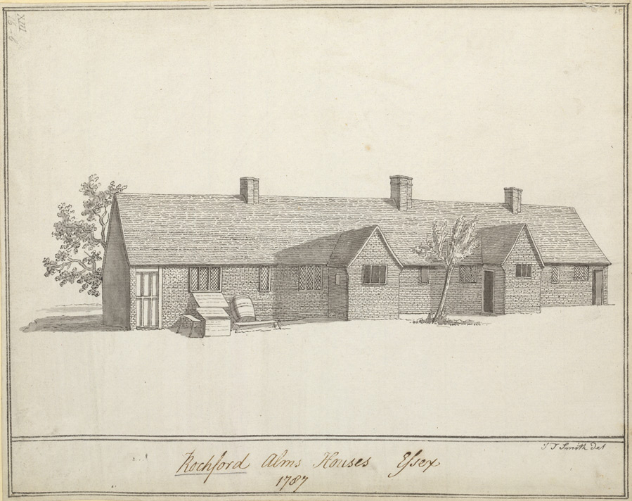
An almshouse (also known as a bede-house, poorhouse, or hospital) is charitable housing provided to people in a particular community, especially during the Middle Ages. They were often built for the poor of a locality, for those who had held certain jobs, or their widows, and for elderly people who could no longer pay rent. They are generally maintained by a charity or the trustees of a bequest. " Alms" are, in the Christian tradition, money or services donated to support the poor and indigent. Almshouses were originally formed as extensions of the church system and were later adapted by local officials and authorities. History Many almshouses are European Christian institutions though some are secular. Almshouses provide subsidised accommodation, often integrated with social care resources such as wardens. England Almshouses were established from the 10th century in Britain, to provide a place of residence for poor, old, and distressed people. They were sometimes called b ... [...More Info...] [...Related Items...] OR: [Wikipedia] [Google] [Baidu] |
Gibraltar
Gibraltar ( , ) is a British Overseas Territories, British Overseas Territory and British overseas cities, city located at the southern tip of the Iberian Peninsula, on the Bay of Gibraltar, near the exit of the Mediterranean Sea into the Atlantic Ocean (Strait of Gibraltar). It has an area of and is Gibraltar–Spain border, bordered to the north by Spain (Campo de Gibraltar). The landscape is dominated by the Rock of Gibraltar, at the foot of which is a densely populated town area. Gibraltar is home to some 34,003 people, primarily Gibraltarians. Gibraltar was founded as a permanent watchtower by the Almohad Caliphate, Almohads in 1160. It switched control between the Nasrids, Crown of Castile, Castilians and Marinids in the Late Middle Ages, acquiring larger strategic clout upon the destruction of nearby Algeciras . It became again part of the Crown of Castile in 1462. In 1704, Anglo-Dutch forces Capture of Gibraltar, captured Gibraltar from Spain during the War of the S ... [...More Info...] [...Related Items...] OR: [Wikipedia] [Google] [Baidu] |
George Augustus Eliott, 1st Baron Heathfield
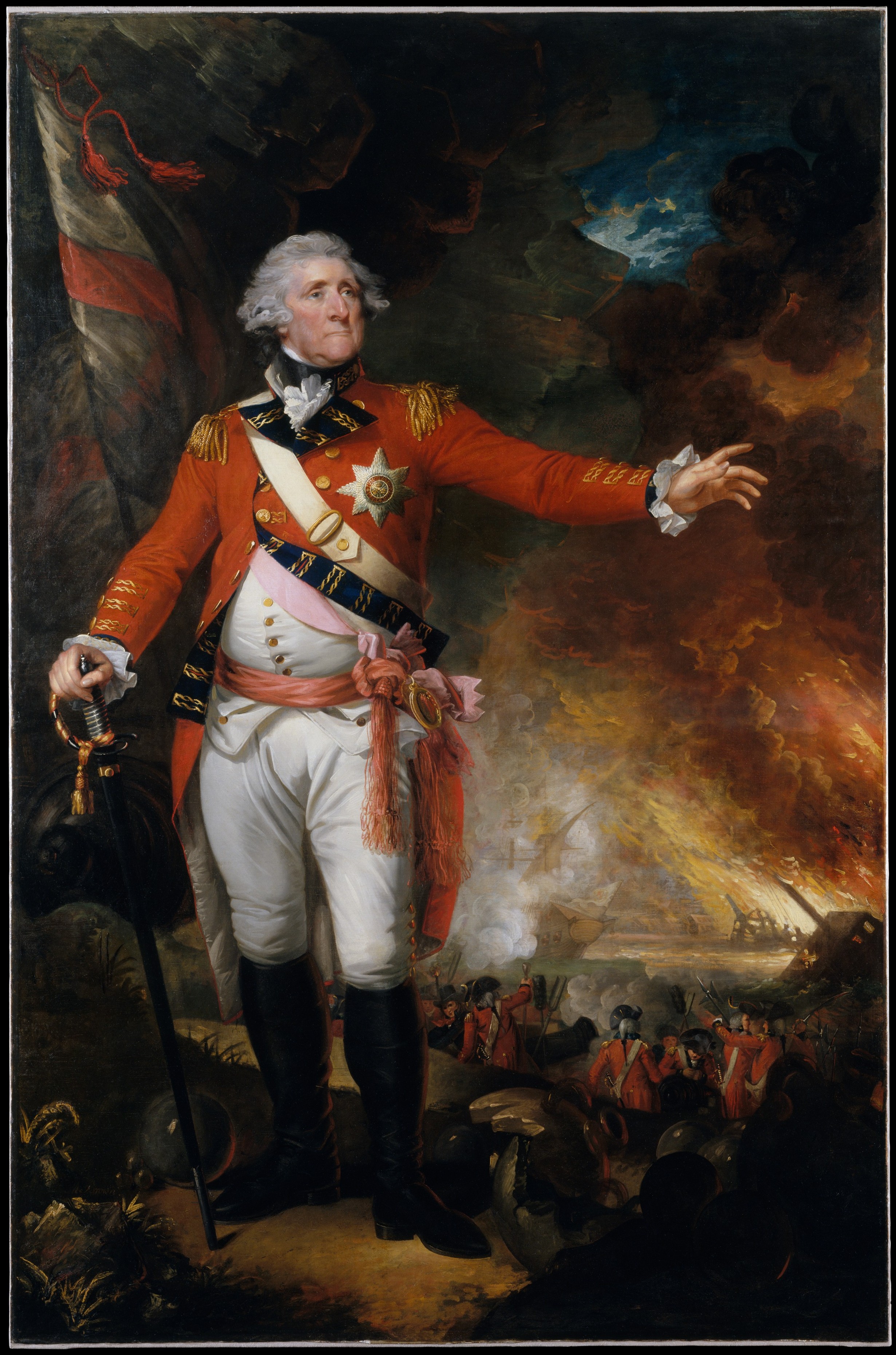
General George Augustus Eliott, 1st Baron Heathfield, (25 December 1717 – 6 July 1790) was a British Army officer who served as the governor of Gibraltar from 1779 to 1790. Eliott rose to distinction during the Seven Years' War when he fought in Germany and participated in the capture of Belle Île and siege of Havana. He is most notable for his command of the Gibraltar garrison during the Great Siege of Gibraltar, which lasted from 1779 to 1783, during the American War of Independence. He was celebrated for his successful defence of the fortress and decisive defeat of Spanish and French attackers. Life Early life Eliott was born at Wells House, near Stobs Castle, Roxburghshire, the 10th (and 8th surviving) son of Sir Gilbert Eliott, 3rd Baronet, of Stobs, by his distant cousin Eleanor Elliot of Brugh and Wells in Roxburghshire. Eleanor's brother was the soldier and courtier William Elliot of Wells. One of his Eleanor's sisters, Charlotte, had married Roger Elliott, ... [...More Info...] [...Related Items...] OR: [Wikipedia] [Google] [Baidu] |
Drake Baronets
There have been four baronetcies created for people with the surname Drake, three in the Baronetage of England and one in the Baronetage of Great Britain. Drake Baronetcy of Buckland The Drake Baronetcy of Buckland, in the County of Devon, was created in the Baronetage of England on 2 August 1622 for Francis Drake, nephew of the privateer and explorer Sir Francis Drake. The first baronet was also a Member of Parliament, as were all his successors. The baronets' seat was originally Buckland Abbey, Sir Francis Drake's home, but upon their inheritance of Nutwell Court, near Exeter, the Drakes ceased to live year-round at Buckland. A daughter of the fourth baronet was the wife of George Augustus Eliott, 1st Baron Heathfield, the defender of Gibraltar, and their descendants ultimately inherited both Buckland Abbey and Nutwell Court. The baronetcy became dormant, and probably extinct, on the death of the fifth baronet in 1794. Relationship to Drake of Ash The family relatio ... [...More Info...] [...Related Items...] OR: [Wikipedia] [Google] [Baidu] |


