|
Buchan
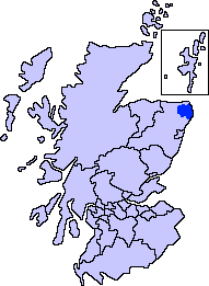
Buchan is an area of north-east Scotland, historically one of the original provinces of the Kingdom of Alba. It is now one of the six committee areas and administrative areas of Aberdeenshire Council, Scotland. These areas were created by the council in 1996, when the Aberdeenshire council area was created under the Local Government etc (Scotland) Act 1994. The council area was formed by merging three districts of the Grampian Region: Banff and Buchan, Gordon and Kincardine and Deeside. The committee area of Buchan was formed from part of the former district of Banff and Buchan. Etymology The genesis of the name ''Buchan'' is shrouded in uncertainty, but may be of Pictish origin. The name may involve an equivalent of Welsh ''buwch'' meaning "a cow". American academic Thomas Clancy has noted cautiously the similarity between the territory names ''Buchan'' and ''Marr'' to those of the Welsh commotes ''Cantref Bychan'' and ''Cantref Mawr'', meaning "small-" and "large-commote ... [...More Info...] [...Related Items...] OR: [Wikipedia] [Google] [Baidu] |
Earl Of Buchan
The Mormaer () or Earl of Buchan () was originally the provincial ruler of the medieval province of Buchan. Buchan was the first Mormaerdom in the High Medieval Kingdom of the Scots The Kingdom of Scotland (; , ) was a sovereign state in northwest Europe traditionally said to have been founded in 843. Its territories expanded and shrank, but it came to occupy the northern third of the island of Great Britain, sharing a la ... to pass into the hands of a non-Scottish family in the male line. The earldom had three lines in its history, not counting passings from female heirs to sons. Today, it is held by the Erskine family as a peerage. The current holder is Harry Erskine, 18th Earl of Buchan (b. 1960). Mormaerdom of Buchan The first recorded person who definitely held the position of mormaer was Gartnait, Earl of Buchan, Gartnait, whose patronage is noted in the Middle Irish, Gaelic Notes on the ''Book of Deer''. The latter is the only significant source for the mormaerd ... [...More Info...] [...Related Items...] OR: [Wikipedia] [Google] [Baidu] |
Buchan (district)
Buchan is an area of north-east Scotland, historically one of the original provinces of the Kingdom of Alba. It is now one of the six committee areas and administrative areas of Aberdeenshire Council, Scotland. These areas were created by the council in 1996, when the Aberdeenshire council area was created under the Local Government etc (Scotland) Act 1994. The council area was formed by merging three districts of the Grampian Region: Banff and Buchan, Gordon and Kincardine and Deeside. The committee area of Buchan was formed from part of the former district of Banff and Buchan. Etymology The genesis of the name ''Buchan'' is shrouded in uncertainty, but may be of Pictish origin. The name may involve an equivalent of Welsh ''buwch'' meaning "a cow". American academic Thomas Clancy has noted cautiously the similarity between the territory names ''Buchan'' and ''Marr'' to those of the Welsh commotes ''Cantref Bychan'' and ''Cantref Mawr'', meaning "small-" and "large-commote" ... [...More Info...] [...Related Items...] OR: [Wikipedia] [Google] [Baidu] |
Banff And Buchan
Banff and Buchan is a committee area of the Aberdeenshire Council, Scotland. It has a population of 35,742 (2001 Census). Fishing and agriculture are important industries, together with associated processing and service activity. Banff and Buchan was also the name of a district of Grampian Region between 1975 and 1996. The district covered a much larger area than the committee area, and included what are now the committee areas of Buchan, which, despite its name, is not part of the committee area of Banff and Buchan, and Formartine. Banff and Buchan committee area The area is relatively self-contained, and in recent years has seen a small decline in population. It does, however, have tourism assets in its coastline, coastal villages and visitor attractions. Economic dependency, peripherality, and the future of the Common Fisheries/Agricultural Policies, are key issues. The Buchan Local Action Plan will address some of these concerns. The Area qualifies for European Union ... [...More Info...] [...Related Items...] OR: [Wikipedia] [Google] [Baidu] |
Aberdeenshire Council
Aberdeenshire ( sco, Aiberdeenshire; gd, Siorrachd Obar Dheathain) is one of the 32 council areas of Scotland. It takes its name from the County of Aberdeen which has substantially different boundaries. The Aberdeenshire Council area includes all of the area of the historic counties of Aberdeenshire and Kincardineshire (except the area making up the City of Aberdeen), as well as part of Banffshire. The county boundaries are officially used for a few purposes, namely land registration and lieutenancy. Aberdeenshire Council is headquartered at Woodhill House, in Aberdeen, making it the only Scottish council whose headquarters are located outside its jurisdiction. Aberdeen itself forms a different council area (Aberdeen City). Aberdeenshire borders onto Angus and Perth and Kinross to the south, Highland and Moray to the west and Aberdeen City to the east. Traditionally, it has been economically dependent upon the primary sector (agriculture, fishing, and forestry) and r ... [...More Info...] [...Related Items...] OR: [Wikipedia] [Google] [Baidu] |
Pictish
Pictish is the extinct Brittonic language spoken by the Picts, the people of eastern and northern Scotland from Late Antiquity to the Early Middle Ages. Virtually no direct attestations of Pictish remain, short of a limited number of geographical and personal names found on monuments and the contemporary records in the area controlled by the kingdoms of the Picts, dating to the early medieval period. Such evidence, however, points strongly to the language being an Insular Celtic language related to the Brittonic language spoken prior to Anglo-Saxon settlement in what is now southern Scotland, England, and Wales. The prevailing view in the second half of the 20th century was that Pictish was a non-Indo-European language isolate, predating a Gaelic colonisation of Scotland or that a non-Indo-European Pictish and Brittonic Pictish language coexisted. Pictish was replaced by – or subsumed into – Gaelic in the latter centuries of the Pictish period. During the reign of Dom ... [...More Info...] [...Related Items...] OR: [Wikipedia] [Google] [Baidu] |
Scotland
Scotland (, ) is a country that is part of the United Kingdom. Covering the northern third of the island of Great Britain, mainland Scotland has a border with England to the southeast and is otherwise surrounded by the Atlantic Ocean to the north and west, the North Sea to the northeast and east, and the Irish Sea to the south. It also contains more than 790 islands, principally in the archipelagos of the Hebrides and the Northern Isles. Most of the population, including the capital Edinburgh, is concentrated in the Central Belt—the plain between the Scottish Highlands and the Southern Uplands—in the Scottish Lowlands. Scotland is divided into 32 administrative subdivisions or local authorities, known as council areas. Glasgow City is the largest council area in terms of population, with Highland being the largest in terms of area. Limited self-governing power, covering matters such as education, social services and roads and transportation, is devolved from the ... [...More Info...] [...Related Items...] OR: [Wikipedia] [Google] [Baidu] |
Cruden Bay
Cruden Bay is a small village in Scotland, on the north coast of the Bay of Cruden in Aberdeenshire, north of Aberdeen. Just west of Slains Castle, Cruden Bay is said to have been the site of a battle in which the Scots under King Malcolm II defeated the Danes in 1012. Traditionally, the name was derived from the Gaelic ''Croch Dain'' (Slaughter of Danes). Today, Cruden Bay attracts tourists with its hotels and golf course. It has a long, unspoiled, beach made famous by Norwegian aviator Tryggve Gran who made the first solo flight across the North Sea. Literary associations The village has associations with various figures in literature. Dr Samuel Johnson and James Boswell were guests at Slains Castle in 1773. Johnson said that "no man can see with indifference" the sea chasm known as the Bullers of Buchan, which is near the village. Dun Bay, or Yellow Rock is also near the Bullers of Buchan, and is associated with Walter Scott's '' The Antiquary''. Bram Stoker was a ... [...More Info...] [...Related Items...] OR: [Wikipedia] [Google] [Baidu] |
Kingdom Of Alba
The Kingdom of Alba ( la, Scotia; sga, Alba) was the Kingdom of Scotland between the deaths of Donald II in 900 and of Alexander III in 1286. The latter's death led indirectly to an invasion of Scotland by Edward I of England in 1296 and the First War of Scottish Independence. Alba included Dalriada, but not large parts of the present day Scottish Lowlands, which were then divided between Strathclyde and Northumbria as far north as the Firth of Forth. Fortriu, a Pictish kingdom in the north, was added to Alba in the tenth century. Until the early 13th century, Moray was not considered part of Alba, which was seen as extending only between the Firth of Forth and the River Spey. The name of Alba is one of convenience, as throughout this period both the ruling and lower classes of the Kingdom were predominantly Pictish-Gaels, later Pictish-Gaels and Scoto-Normans. This differs markedly from the period of the House of Stuart, beginning in 1371, in which the ruling classes o ... [...More Info...] [...Related Items...] OR: [Wikipedia] [Google] [Baidu] |
Local Government Etc (Scotland) Act 1994
The Local Government etc. (Scotland) Act 1994 (c. 39) is an Act of the Parliament of the United Kingdom which created the current local government structure of 32 unitary authorities covering the whole of Scotland. It abolished the two-tier structure of regions and districts created by the Local Government (Scotland) Act 1973 which had previously covered Scotland except for the islands council areas. The Act came into effect on 1 April 1996, applying beginning with the 1995 Scottish local elections. Initial proposals The Secretary of State for Scotland, Ian Lang outlined proposed areas in a statement to the Commons on 8 July 1993. This outlined 25 unitary authorities (apart from the 3 Island Areas), as follows * City of Aberdeen: existing Aberdeen District plus Westhill area of Gordon District * Aberdeenshire: Banff and Buchan District, Gordon District less Westhill area, Kincardine and Deeside District less southern part of former County of Kincardineshire * Angus ... [...More Info...] [...Related Items...] OR: [Wikipedia] [Google] [Baidu] |
Cullen, Moray
Cullen ( gd, Inbhir Cuilinn) is a village and former royal burgh in Moray, Scotland, on the North Sea coast east of Elgin. The village had a population of 1,327 in 2001.United Kingdom Census 2001Cullen census data Cullen is noticeably busier in summer than winter due to the number of holiday homes owned. The organs of the wife of are said to have been buried in its old (church) after her death in Cullen Castle.Coventry, Martin (2001). ''The C ... [...More Info...] [...Related Items...] OR: [Wikipedia] [Google] [Baidu] |
Grampian Region
Grampian ( gd, Roinn a' Mhonaidh) was one of nine former local government regions of Scotland created in 1975 by the Local Government (Scotland) Act 1973 and abolished in 1996 by the Local Government etc. (Scotland) Act 1994. The region took its name from the Grampian Mountains. It is now divided into the unitary council areas of Aberdeenshire, City of Aberdeen and Moray. Geography Grampian had boundaries with the Highlands to the east (Inverness-shire, Nairnshire) and Tayside to the south (Angus, Perth and Kinross). It was made up of the historical counties of Aberdeenshire, City of Aberdeen, Kincardineshire and Morayshire in northeast Scotland. Moray included the historical county of Banffshire. Grampian was divided into five districts - Aberdeen, Banff and Buchan, Gordon, Kincardine and Deeside and Moray. Aberdeen is the major city of the region. Other major towns are the former royal burgh of Elgin, the major fishing port of Peterhead, Fraserburgh, In ... [...More Info...] [...Related Items...] OR: [Wikipedia] [Google] [Baidu] |

.png)


Aug1990.jpg)
