|
Brule River (Minnesota)
The Brule River is a river of the U.S. state of Minnesota. The Brule River originates at Vista Lake in the Boundary Waters Canoe Area Wilderness and flows U.S. Geological Survey. National Hydrography Dataset high-resolution flowline dataThe National Map, accessed May 2, 2012 east and southeast, terminating at Lake Superior approximately northeast of Grand Marais, Minnesota, within the boundaries of Judge C. R. Magney State Park. A major tributary is the South Brule River, which rises at the east end of Brule Lake in the Boundary Waters Canoe Area Wilderness The river's original name of (Burnt Wood River) may have referenced a forest fire. Brule River is a name derived from the French meaning "burnt"; the English name has lost the diacritic and has an anglicized, monosyllabic pronunciation ( ). Half of the river disappears into a pothole known as "the Devil's Kettle" in Judge C. R. Magney State Park. Studies in 2017 showed that the water comes up at the bottom of the river n ... [...More Info...] [...Related Items...] OR: [Wikipedia] [Google] [Baidu] |
United States
The United States of America (USA), also known as the United States (U.S.) or America, is a country primarily located in North America. It is a federal republic of 50 U.S. state, states and a federal capital district, Washington, D.C. The 48 contiguous states border Canada to the north and Mexico to the south, with the semi-exclave of Alaska in the northwest and the archipelago of Hawaii in the Pacific Ocean. The United States asserts sovereignty over five Territories of the United States, major island territories and United States Minor Outlying Islands, various uninhabited islands in Oceania and the Caribbean. It is a megadiverse country, with the world's List of countries and dependencies by area, third-largest land area and List of countries and dependencies by population, third-largest population, exceeding 340 million. Its three Metropolitan statistical areas by population, largest metropolitan areas are New York metropolitan area, New York, Greater Los Angeles, Los Angel ... [...More Info...] [...Related Items...] OR: [Wikipedia] [Google] [Baidu] |
Minnesota
Minnesota ( ) is a U.S. state, state in the Upper Midwestern region of the United States. It is bordered by the Canadian provinces of Manitoba and Ontario to the north and east and by the U.S. states of Wisconsin to the east, Iowa to the south, and North Dakota and South Dakota to the west. It is the List of U.S. states and territories by area, 12th-largest U.S. state in area and the List of U.S. states and territories by population, 22nd-most populous, with about 5.8 million residents. Minnesota is known as the "Land of 10,000 Lakes"; it has 14,420 bodies of fresh water covering at least ten acres each. Roughly a third of the state is Forest cover by state and territory in the United States, forested. Much of the remainder is prairie and farmland. More than 60% of Minnesotans (about 3.71 million) live in the Minneapolis–Saint Paul metropolitan area, known as the "Twin Cities", which is Minnesota's main Politics of Minnesota, political, Economy of Minnesota, economic, and C ... [...More Info...] [...Related Items...] OR: [Wikipedia] [Google] [Baidu] |
Cook County
Cook County is the most populous county in the U.S. state of Illinois and the second-most-populous county in the United States, after Los Angeles County, California. More than 40 percent of all residents of Illinois live within Cook County. the population was 5,275,541. The county seat is Chicago, the most populous city in Illinois and the third most populous city in the United States. The county is at the center of the Chicago metropolitan area. Cook county is also the sixth largest county in Illinois by area. Cook County was incorporated in 1831 and named for Daniel Pope Cook, an early Illinois statesman. It achieved its present boundaries in 1839. Within a century, the county recorded explosive population growth, going from a trading post village with a little over six hundred residents to four million, rivaling Paris by the Great Depression. During the first half of the 20th century it had the absolute majority of Illinois's population. There are more than 800 local ... [...More Info...] [...Related Items...] OR: [Wikipedia] [Google] [Baidu] |
Lake Superior
Lake Superior is the largest freshwater lake in the world by surface areaThe Caspian Sea is the largest lake, but is saline, not freshwater. Lake Michigan–Huron has a larger combined surface area than Superior, but is normally considered two separate lakes. and the third-largest freshwater lake by volume, holding 10% of the fresh water in all of the world's rivers and lakes. Located in central North America, it is the northernmost and westernmost of the Great Lakes of North America, straddling the Canada–United States border with the Canadian province of Ontario to the north and east and the U.S. states of Minnesota to the west and Michigan and Wisconsin to the south. It drains into Lake Huron via St. Marys River, then through the lower Great Lakes to the St. Lawrence River and ultimately the Atlantic Ocean. Name The Ojibwe name for the lake is ''gichi-gami'' (in syllabics: , pronounced ''gitchi-gami'' or ''kitchi-gami'' in different dialects), meaning "great sea". ... [...More Info...] [...Related Items...] OR: [Wikipedia] [Google] [Baidu] |
Boundary Waters Canoe Area Wilderness
The Boundary Waters Canoe Area Wilderness (BWCAW or BWCA) comprises of pristine forests, glacial lakes, and streams in the Superior National Forest. Located entirely within the U.S. state of Minnesota at the Boundary Waters, the wilderness area is under the administration of the United States Forest Service. Efforts to preserve the primitive landscape began in the 1900s and culminated in the Boundary Waters Canoe Area Wilderness Act of 1978. The area is a popular destination for canoeing, hiking, and fishing, and is the most visited wilderness in the United States. Geography The BWCAW extends along of the Canadian border in the Arrowhead Region of Minnesota. The combined region of the BWCAW, Superior National Forest, Voyageurs National Park, and Ontario's Quetico and La Verendrye provincial parks make up a large area of contiguous wilderness lakes and forests called the "Quetico-Superior country", or simply the Boundary Waters. Lake Superior lies to the south and east ... [...More Info...] [...Related Items...] OR: [Wikipedia] [Google] [Baidu] |
Grand Marais, Minnesota
Grand Marais ( ) is a city and the county seat of Cook County, Minnesota, Cook County, Minnesota, United States, of which it is the only municipality. It is on Lake Superior's North Shore. Grand Marais had a population of 1,337 at the 2020 United States census, 2020 census. Before it was settled by French Canadians and before Minnesota's statehood, it was inhabited by the Ojibwe. The Gunflint Trail, a National Scenic Byway, begins in Grand Marais and ends near the border with Ontario. History The Ojibwe name for the area is ''Gichi-biitoobiig'', which means "great duplicate water," "parallel body of water" or "double body of water" (like a bayou), a reference to the two bays that form this large harbor of Lake Superior. The area was a bustling fur trading station in the 1700s, and the French Canadian Voyageurs termed the settled village "Grand Marais" ("Great Marsh"), referring to a marsh that, in early fur-trading times, was 20 acres (8.1 ha) or less in area, nearly at the le ... [...More Info...] [...Related Items...] OR: [Wikipedia] [Google] [Baidu] |
Judge C
A judge is a person who presides over court proceedings, either alone or as a part of a judicial panel. In an adversarial system, the judge hears all the witnesses and any other evidence presented by the barristers or solicitors of the case, assesses the credibility and arguments of the parties, and then issues a ruling in the case based on their interpretation of the law and their own personal judgment. A judge is expected to conduct the trial impartially and, typically, in an open court. The powers, functions, method of appointment, discipline, and training of judges vary widely across different jurisdictions. In some jurisdictions, the judge's powers may be shared with a jury. In inquisitorial systems of criminal investigation, a judge might also be an examining magistrate. The presiding judge ensures that all court proceedings are lawful and orderly. Powers and functions The ultimate task of a judge is to settle a legal dispute in a final and publicly lawful manner in agr ... [...More Info...] [...Related Items...] OR: [Wikipedia] [Google] [Baidu] |
South Brule River
South is one of the cardinal directions or compass points. The direction is the opposite of north and is perpendicular to both west and east. Etymology The word ''south'' comes from Old English ''sūþ'', from earlier Proto-Germanic ''*sunþaz'' ("south"), possibly related to the same Proto-Indo-European root that the word ''sun'' derived from. Some languages describe south in the same way, from the fact that it is the direction of the sun at noon (in the Northern Hemisphere), like Latin meridies 'noon, south' (from medius 'middle' + dies 'day', ), while others describe south as the right-hand side of the rising sun, like Biblical Hebrew תֵּימָן teiman 'south' from יָמִין yamin 'right', Aramaic תַּימנַא taymna from יָמִין yamin 'right' and Syriac ܬܰܝܡܢܳܐ taymna from ܝܰܡܝܺܢܳܐ yamina (hence the name of Yemen, the land to the south/right of the Levant). South is sometimes abbreviated as S. Navigation By convention, the ''bottom or down-f ... [...More Info...] [...Related Items...] OR: [Wikipedia] [Google] [Baidu] |
Brule Lake (Minnesota)
Brule Lake is a lake in Cook County, Minnesota. It is situated between two long sills in the Superior Upland, causing the lake to be eight times longer east and west than it is north and south. Out of the opposite ends flow the Temperance River and the South Brule, a tributary of the Brule River. Brule Lake was logged heavily in the early 1900s, and the region around it was consumed in 1929 by a logging-related forest fire which bears Brule Lake's name. Now the lake is part of the protected Boundary Waters Canoe Area, a federal wilderness area for which Brule Lake serves as an entrance point. Topography Brule Lake is one of the largest lakes in the eastern Arrowhead Region of Minnesota.Minnesota Game and Fish Department. Fins, Feathers and Fur.' vol. 29–54. p.43 Sept. 1925. It has an area of 4272 acres, and a maximum depth of 78 feet. It sits 1851 feet above sea level.Minnesota State Drainage Commission. Report of the Water Resources Investigation of Minnesota, 1911–1912.' p ... [...More Info...] [...Related Items...] OR: [Wikipedia] [Google] [Baidu] |
Giant's Kettle
A giant's kettle, also known as either a giant's cauldron, moulin pothole, or glacial pothole, is a typically large and cylindrical Pothole (landform), pothole drilling, drilled in solid rock (geology), rock underlying a glacier either by water descending down a deep Moulin (geomorphology), moulin or by gravel rotating in the bed of Subglacial stream, subglacial meltwater stream.Neuendorf, K.K.E., J.P. Mehl, Jr., and J.A. Jackson, eds. (2005) ''Glossary of Geology'' (5th ed.). Alexandria, Virginia, American Geological Institute. 779 pp. The interiors of potholes tend to be smooth and regular, unlike a plunge pool. Formation Giant's kettles are formed while a bedrock surface is covered by a glacier. Water, produced by the thawing of the ice and snow, forms streams on the surface of the glacier, which, having gathered into their courses a certain amount of Moraine, morainic debris, finally flow down a crevasse as a swirling waterfall, cascade or Moulin (geomorphology), moulin. ... [...More Info...] [...Related Items...] OR: [Wikipedia] [Google] [Baidu] |
List Of Rivers Of Minnesota
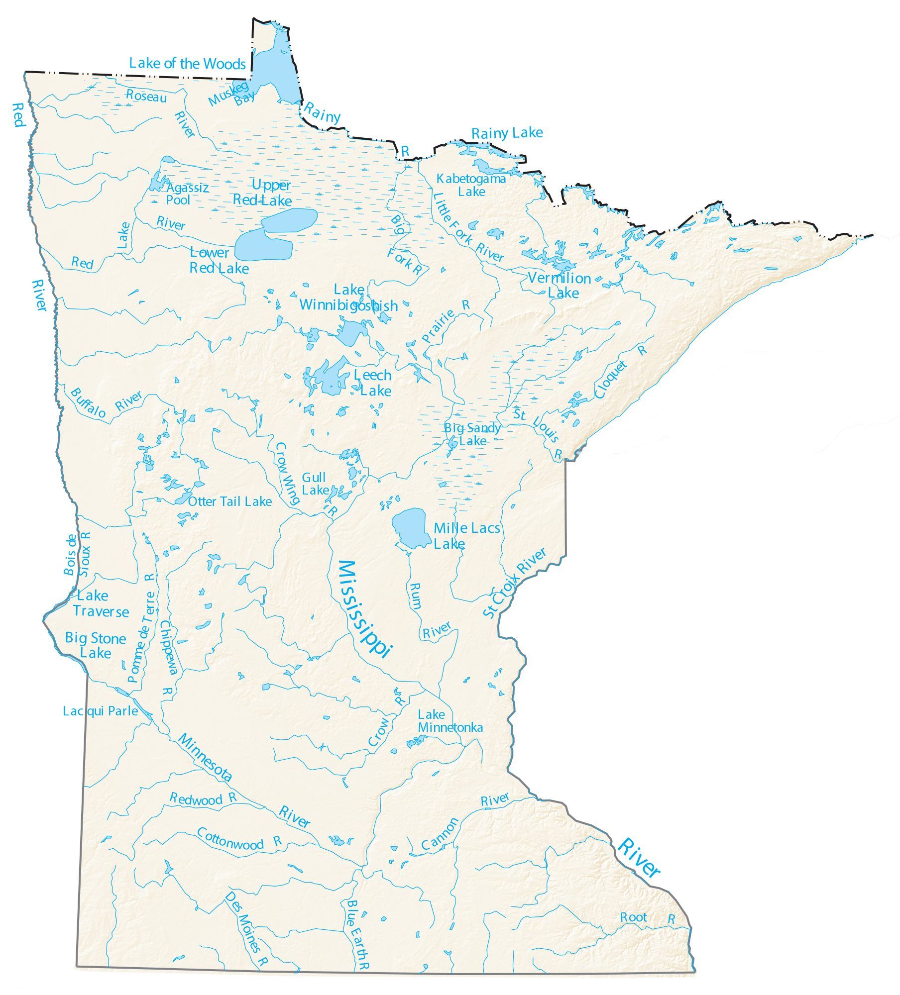
Minnesota has 6,564 natural rivers and streams that cumulatively flow for . The Mississippi River begins its journey from its headwaters at Lake Itasca and crosses the Iowa border downstream. It is joined by the Minnesota River at Fort Snelling, by the St. Croix River near Hastings, by the Chippewa River at Wabasha, and by many smaller streams. The Red River, in the bed of glacial Lake Agassiz, drains the northwest part of the state northward toward Canada's Hudson Bay. By drainage basin (watershed) This list is arranged by drainage basin with respective tributaries indented under each larger stream's name.Note: In North America, the term watershed is commonly used to mean a drainage basin, though in other English-speaking countries, it is used only in its original sense, that of a drainage divide. The rivers and streams that flow through other states or Minnesota and other states are indicated, as well as the length of major rivers. Great Lakes drainage basin La ... [...More Info...] [...Related Items...] OR: [Wikipedia] [Google] [Baidu] |
List Of Longest Streams Of Minnesota
Out of the 6,564 streams that flow through the U.S. State of Minnesota, there are 114 streams that are at least 30 miles long. The second longest river in the United States, the Mississippi River, originates in Minnesota before flowing south to the Gulf of Mexico. The longest river entirely within the state of Minnesota is the Minnesota River. Other rivers over 200 miles long include the Red River of the North, Des Moines River, Cedar River (Iowa River tributary), Cedar River, Wapsipinicon River, Little Sioux River, and Roseau River (Manitoba–Minnesota), Roseau River. Sections of several of the longest rivers define sections of the Minnesota border. The Red River of the North forms the border with North Dakota to the west. The Bois de Sioux River forms the border with South Dakota to the west. The Mississippi River, St. Croix River (Wisconsin-Minnesota), St. Croix River, and the Saint Louis River (Lake Superior tributary), St. Louis River form the border with Wisconsin ... [...More Info...] [...Related Items...] OR: [Wikipedia] [Google] [Baidu] |


