|
Bourg-Madame
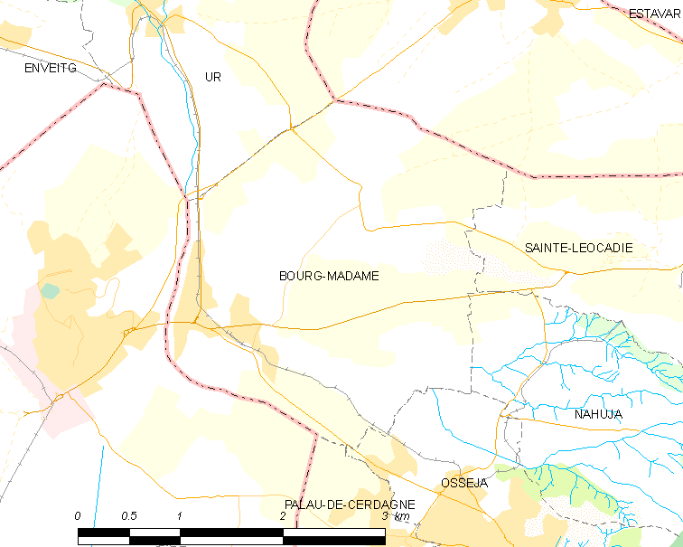
Bourg-Madame (; ; ) is a commune in the Pyrénées-Orientales department in southern France. Geography Localisation Bourg-Madame is located in the canton of Les Pyrénées catalanes and in the arrondissement of Prades. It lies right on the border with Spain. It abuts directly onto the Spanish town of Puigcerdà, and is near the Spanish exclave of Llívia. Toponymy The town used to be known in French as ''Les Guinguettes'', until 1815 when it was renamed Bourg-Madame in honour of the wife of the Duke of Angoulême. The Catalan name for the town is still the traditional one. History In the 20th century, Bourg-Madame was the site of a camp housing Republican escapees from Spain at the end of the Spanish Civil War. Government and politics Mayors Transport Roads The following major roads lead to Bourg-Madame: * N-20 from Ur to the north; * N-154 and D-68 from the Spanish enclave Llívia to the northeast; * N-116 from Saillagouse to the east; * D-30 and D-70 ... [...More Info...] [...Related Items...] OR: [Wikipedia] [Google] [Baidu] |
Bourg-Madame Station
Bourg-Madame is a railway station in Bourg-Madame, Occitania (administrative region), Occitanie, France. The station is on the Ligne de Cerdagne. The line is a narrow gauge line at 1,000 mm (3 ft 3 3⁄8 in) and has a third rail pickup at 750 V DC (3rd Rail). The station is served by TER Occitanie (local) trains (known as ''Train Jaune'') operated by the SNCF. Train services The following services currently call at Bourg-Madame: TER Occitanie, accessed 12 May 2022. *local service (TER Occitanie) Latour-de-Carol-Enveitg–Font-Romeu–Villefranche-Vernet-les-Bains Gallery References |
Ligne De Cerdagne
The ''Ligne de Cerdagne'' (), usually referred to as ''Le Petit Train Jaune'' (, ), is a gauge railway that runs from Villefranche-de-Conflent to Latour-de-Carol- Enveitg in the French Pyrenees. History of the Line The section of line between Villefranche-de-Conflent and Bourg-Madame was declared a public utility by law on 4 March 1903. This same law approved the granting of a concession for the line, signed on 5 December 1902, between the Minister of Public Works and the Compagnie des Chemins de Fer du Midi et du Canal Latéral à la Garonne. The law also superseded an earlier proposed standard gauge railway which had been authorised between Villefranche-de-Conflent and Olette, but never built. A second law was approved on 23 March 1914 to extend the railway from Bourg-Madame to the 'French frontier station' of the transpyrenean line from Ax les Thermes to Ripoll, although the present station name at the terminus of Latour de Carol Enveitg was not mentioned. The declarati ... [...More Info...] [...Related Items...] OR: [Wikipedia] [Google] [Baidu] |
Communes Of The Pyrénées-Orientales Department
The Pyrénées-Orientales departments of France, department is composed of 226 communes of France, communes. Most of the territory (except for the district of Fenolheda) formed a part of the Principality of Catalonia until 1659, and Catalan language, Catalan is still spoken (in addition to French language, French) by a significant minority of the population. The Catalan names of communes are taken from the ''Enciclopèdia catalana'' and are intended for comparison with the official French names: they do not indicate the current or former linguistic status of the commune. List of intercommunalities The communes cooperate in the following Communes of France#Intercommunality, intercommunalities (as of 2025):Périmètre des groupements en 2025 BANATIC. Accessed 28 May 2025. *Communauté urbaine Perpignan Médit ... [...More Info...] [...Related Items...] OR: [Wikipedia] [Google] [Baidu] |
Puigcerdà
Puigcerdà (; , ) is the capital city, capital of the Catalan ''comarques of Catalonia, comarca'' of Cerdanya (comarca), Cerdanya, in the province of Girona, Catalonia, northern Spain, near the Segre River and on the border with France (it abuts directly on the French town of Bourg-Madame). It has a population of . History Puigcerdà is located near the site of a Ceretani settlement, which was incorporated into Roman territory. The Roman town was named Julia Libyca (modern day Llívia). Puigcerdà was founded in 1178 by King Alfonso I of Aragon, Count of Barcelona. In 1178 Puigcerdà replaced Hix, Cerdanya, Hix as the capital of Cerdanya. Hix is now a village in the commune in France, commune of Bourg-Madame, in the French Cerdagne, French part of Cerdanya. In the closing stages of the 1672–1678 Franco-Dutch War, the town was captured by a French army under the Anne_Jules_de_Noailles, duc de Noailles but returned to Spain in the Treaties of Nijmegen. Puigcerdà was unique ... [...More Info...] [...Related Items...] OR: [Wikipedia] [Google] [Baidu] |
Llívia
Llívia (; ) is a town in the '' comarca'' of Cerdanya, province of Girona, Catalonia, Spain. It is a Spanish exclave surrounded by the French '' département'' of Pyrénées-Orientales. It is named after Livia, the wife of Augustus and matriarch of the Julio-Claudian dynasty. Because of a technicality in the Treaty of the Pyrenees, signed in 1659, that transferred only "villages" in the Pyrenees to France, Llívia, which was a "town", remains under Spanish control. The Segre river, a tributary of the Spanish Ebro, flows through Llívia. It has a population of . Llívia is separated from the rest of Spain by a corridor approximately wide, which includes the French communes of Ur and Bourg-Madame. This corridor is traversed by a road, owned by both France (where it is part of Route nationale 20 and RD68) and Spain (where it is part of N-154). Before the implementation of the Schengen Area, it was considered a "neutral road", a custom-free route with access for both Fr ... [...More Info...] [...Related Items...] OR: [Wikipedia] [Google] [Baidu] |
Canton Of Les Pyrénées Catalanes
The canton of Les Pyrénées catalanes is an administrative division of the Pyrénées-Orientales department, in Southern France. It was created at the French canton reorganisation which came into effect in March 2015. Its seat is in Prades. List of communes It consists of the following 62 communes: # Les Angles # Angoustrine-Villeneuve-des-Escaldes # Ayguatébia-Talau # Bolquère # Bourg-Madame #La Cabanasse # Campôme # Canaveilles # Catllar # Caudiès-de-Conflent # Clara-Villerach # Codalet # Conat #Dorres # Égat # Enveitg # Err # Escaro # Estavar # Eus # Eyne # Font-Romeu-Odeillo-Via # Fontpédrouse # Fontrabiouse # Formiguères # Jujols # Latour-de-Carol # La Llagonne # Llo # Los Masos # Matemale # Molitg-les-Bains # Mont-Louis # Mosset # Nahuja # Nohèdes # Nyer # Olette # Oreilla # Osséja # Palau-de-Cerdagne #Planès Planès () is a commune in the Pyrénées-Orientales department in southern France. Geography Planès is located in the canton of Les Py ... [...More Info...] [...Related Items...] OR: [Wikipedia] [Google] [Baidu] |
Arrondissement Of Prades
The arrondissement of Prades is an arrondissement of France in the Pyrénées-Orientales department (Northern Catalonia) in the Occitanie region. It has 123 communes. Its population is 60,536 (2021), and its area is . Composition The communes of the arrondissement of Prades, and their INSEE codes, are: # Les Angles (66004) # Angoustrine-Villeneuve-des-Escaldes (66005) # Ansignan (66006) # Arboussols (66007) # Ayguatébia-Talau (66010) # Baillestavy (66013) # Bélesta (66019) # Bolquère (66020) # Boule-d'Amont (66022) # Bouleternère (66023) # Bourg-Madame (66025) # La Cabanasse (66027) # Campôme (66034) # Campoussy (66035) # Canaveilles (66036) # Caramany (66039) # Casefabre (66040) # Casteil (66043) # Catllar (66045) # Caudiès-de-Conflent (66047) # Caudiès-de-Fenouillèdes (66046) # Clara-Villerach (66051) # Codalet (66052) # Conat (66054) # Corbère (66055) # Corbère-les-Cabanes (66056) # Corneilla-de-Conflent (66057) # Corneilla-la-Rivière (6 ... [...More Info...] [...Related Items...] OR: [Wikipedia] [Google] [Baidu] |
Communes Of France
A () is a level of administrative divisions of France, administrative division in the France, French Republic. French are analogous to civil townships and incorporated municipality, municipalities in Canada and the United States; ' in Germany; ' in Italy; ' in Spain; or civil parishes in the United Kingdom. are based on historical geographic communities or villages and are vested with significant powers to manage the populations and land of the geographic area covered. The are the fourth-level administrative divisions of France. vary widely in size and area, from large sprawling cities with millions of inhabitants like Paris, to small hamlet (place), hamlets with only a handful of inhabitants. typically are based on pre-existing villages and facilitate local governance. All have names, but not all named geographic areas or groups of people residing together are ( or ), the difference residing in the lack of administrative powers. Except for the Municipal arrondissem ... [...More Info...] [...Related Items...] OR: [Wikipedia] [Google] [Baidu] |
Toulouse
Toulouse (, ; ; ) is a city in southern France, the Prefectures in France, prefecture of the Haute-Garonne department and of the Occitania (administrative region), Occitania region. The city is on the banks of the Garonne, River Garonne, from the Mediterranean Sea, from the Atlantic Ocean and from Paris. It is the List of communes in France with over 20,000 inhabitants, fourth-largest city in France after Paris, Marseille and Lyon, with 511,684 inhabitants within its municipal boundaries (2022); its Functional area (France), metropolitan area has a population of 1,513,396 inhabitants (2022). Toulouse is the central city of one of the 22 Métropole, metropolitan councils of France. Between the 2014 and 2020 censuses, its metropolitan area was the third fastest growing among metropolitan areas larger than 500,000 inhabitants in France. Toulouse is the centre of the European aerospace industry, with the headquarters of Airbus, the SPOT (satellites), SPOT satellite system, ATR ( ... [...More Info...] [...Related Items...] OR: [Wikipedia] [Google] [Baidu] |
Nahuja
Nahuja (; ) is a small village in the Cerdanya which is part of the Pyrénées-Orientales department in southern France. It is only 8 km far from the Spanish border in Puigcerdà. Its closest neighbour towns are Osséja and Sainte-Léocadie. Geography Nahuja is located in the canton of Les Pyrénées catalanes and in the arrondissement of Prades. Population See also *Communes of the Pyrénées-Orientales department The Pyrénées-Orientales departments of France, department is composed of 226 communes of France, communes. Most of the territory (except for the district of Fenolheda) formed a part of the Principality of Catalonia until 1659, and Catalan lan ...Hiking around Nahuja References Communes of Pyrénées-Orientales {{PyrénéesOrientales-geo-stub ... [...More Info...] [...Related Items...] OR: [Wikipedia] [Google] [Baidu] |
Sainte-Léocadie
Sainte-Léocadie (; , named after the catholic saint Leocadia) is a Communes of France, commune in the Pyrénées-Orientales Departments of France, department in southern France. Geography Sainte-Léocadie is located in the canton of Les Pyrénées catalanes and in the arrondissement of Prades. Sainte-Léocadie station has rail connections to Villefranche-de-Conflent and Latour-de-Carol. Climate Population See also *Communes of the Pyrénées-Orientales department References Communes of Pyrénées-Orientales Pyrénées-Orientales communes articles needing translation from French Wikipedia {{PyrénéesOrientales-geo-stub ... [...More Info...] [...Related Items...] OR: [Wikipedia] [Google] [Baidu] |


