|
Bor District
The Bor District (, ) is one of administrative districts of Serbia , image_flag = Flag of Serbia.svg , national_motto = , image_coat = Coat of arms of Serbia.svg , national_anthem = () , image_map = , map_caption = Location of Serbia (gree .... According to the 2022 census, it has a population of 101,100 inhabitants.https://publikacije.stat.gov.rs/G2023/Pdf/G20234001.pdf This district is the easternmost administrative district of Serbia and contains the Serbian panhandle that extends into the border with Romania. The administrative center of the Bor District is the city of Bor. History The present-day administrative districts (including Bor District) were established in 1992 by the decree of the Government of Serbia. Cities and municipalities The Bor District encompasses the territories of one city and three municipalities: * Bor (city) * Kladovo (municipality) * Majdanpek (municipality) * Neg ... [...More Info...] [...Related Items...] OR: [Wikipedia] [Google] [Baidu] |
Administrative Districts Of Serbia
The administrative districts () of Serbia are the country's first-level administrative division. The term '' okrug'' (pl. ''okruzi'') means "circuit" and corresponds (in literal meaning) to in the German language. It can be translated as "county", though it is generally rendered by the government as "district". Prior to a 2006 decree, the administrative districts were named simply districts. The local government reforms of 1992 created 29 districts, with the City of Belgrade having similar status. Following the 2008 Kosovo declaration of independence, the districts created by the UNMIK-Administration were adopted by Kosovo. The Serbian government does not recognize these districts. The administrative districts are generally named after historical and geographical regions, though some, such as the Pčinja District and the Nišava District, are named after local rivers. Their areas and populations vary, ranging from the relatively-small Podunavlje District to the much larger Zl ... [...More Info...] [...Related Items...] OR: [Wikipedia] [Google] [Baidu] |
Negotin
Negotin ( sr-cyrl, Неготин, ; ) is a town and municipality located in the Bor District of Southern and Eastern Serbia, eastern Serbia. It is situated near the borders between Serbia, Romania and Bulgaria. It is the judicial center of the Bor District. The population of the town is 14,647, while the municipality has a population of 28,261 (2022 census). History Name The etymology of the town's name is unclear, and there are a few possibilities as to its background: # The Romance languages, Romance name origin thesis, such as the ''merchant place'' (cf. Romanian "negoț" or Spanish "negocios"), and the fact that Negotin is in a region with the presence of a significant Romanians, Romanian minority, similar to its namesake Negotino in North Macedonia with an Aromanians, Aromanian presence. # There is also the Slavonic languages, Slavonic origin hypothesis:, Proto-Slavonic "''něga''" (нѣгa) means "care" and the suffix "-ota//-otina" means "the action undergone or carried o ... [...More Info...] [...Related Items...] OR: [Wikipedia] [Google] [Baidu] |
Braničevo District
The Braničevo District (, ) is one of administrative districts of Serbia. According to the 2022 census, it has a population of 156,367 inhabitants.https://publikacije.stat.gov.rs/G2023/Pdf/G20234001.pdf Braničevo District is named after the village of Braničevo. The administrative center of the district is Požarevac. History The present-day administrative districts (including Braničevo District) were established in 1992 by the decree of the Government of Serbia. Municipalities Braničevo District encompasses the territories of one city and 7 municipalities: * Požarevac (city) * Kučevo (municipality) * Golubac (municipality) * Malo Crniće (municipality) * Petrovac (municipality) * Veliko Gradište (municipality) * Žabari (municipality) * Žagubica (municipality) Demographics Towns There is just one town with over 10,000 inhabitants: Požarevac Požarevac ( sr-cyr, Пожаревац, ) is a list of cities in Serbia, city and the administrative centre of th ... [...More Info...] [...Related Items...] OR: [Wikipedia] [Google] [Baidu] |
Pomoravlje District
The Pomoravlje District (, ) is one of eight administrative districts of Šumadija and Western Serbia. It expands to the central parts of Serbia. According to the 2011 census results, it has a population of 214,536 inhabitants. The administrative center is the city of Jagodina. Municipalities The Pomoravlje District contains 6 municipalities (singular: општина, ''opština'' - plural: oпштине, ''opštine''). The following table shows the names of each municipality in the Latin script, Latin and Cyrillic script, Cyrillic scripts and the population of each as of 2011: Demographics According to the last official census done in 2011, the Pomoravlje District has 214,536 inhabitants. 45.35% of the population lives in the urban areas. Ethnic groups Society and culture Culture The nineteenth century architecture has been partly preserved in the district. Earlier times are testified by the remnants of edifices, such as The House of Hajduk Veljko from the eighteenth ... [...More Info...] [...Related Items...] OR: [Wikipedia] [Google] [Baidu] |
Zaječar District
The Zaječar District (, ) is one of administrative districts of Serbia , image_flag = Flag of Serbia.svg , national_motto = , image_coat = Coat of arms of Serbia.svg , national_anthem = () , image_map = , map_caption = Location of Serbia (gree .... It lies in the eastern part of the country. According to the 2022 census, it has a population of 96,715 inhabitants. The administrative center of the Zaječar District is the city of Zaječar. History The present-day administrative districts (including Zaječar District) were established in 1992 by the decree of the Government of Serbia. Cities and municipalities Zaječar District encompasses the territories of one city and three municipalities: * Zaječar (city) * Boljevac (municipality) * Knjaževac (municipality) * Sokobanja (municipality) Demographics Towns There is just one town with over 10,000 inhabitants: Zaječar, with 32,448 inhabitants. ... [...More Info...] [...Related Items...] OR: [Wikipedia] [Google] [Baidu] |
Administrative Divisions Of Serbia
The administrative divisions of Serbia are regulated by the Government decree of 29 January 1992, and by the Law on Territorial Organization adopted by the National Assembly on 29 December 2007.Government of SerbiaDistricts In Serbia/ref>Law on Territorial Organization and Local Self-Government Parliament of Serbia There are two types of administrative divisions in : political (regional and local self-government - ''autonomous provinces'' and ''cities and municipalities'') and administrative (''administrative districts'' for decentralized services of the state and ''statistical regions'' for statistical purposes). Political divisions < ...
|
Romani People In Serbia
Romani people, or Roma (), are the fourth largest ethnic group in Serbia, numbering 131,936 (1.98%) according to the 2022 census. However, due to a legacy of poor birth registration and some other factors, this official number is likely underestimated. Anywhere between 46,000 to 97,000 Roma are internally displaced from Kosovo after 1999. Another name used for the community is ''Cigani'' ( sr-Cyrl, Цигани), although the term is today considered pejorative and is not officially used in public documents. They are divided into numerous subgroups, with different, although related, Romani dialects and history. Subgroups As there are difficulties with the data collection, historization, and with the questionable familiarity of the Serbian scholars with Roma lives and culture and significant demographic changes and migrations of Roma population, it is difficult to establish one definite division within Roma community. According to the study of scholar Tihomir Đorđević (1 ... [...More Info...] [...Related Items...] OR: [Wikipedia] [Google] [Baidu] |
Vlachs Of Serbia
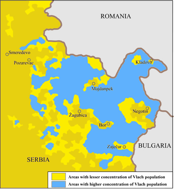
The Vlachs (; / ) are a Romanian language, Romanian-speaking population group living in eastern Serbia, mainly within the Timok Valley. They are characterized by a culture that has preserved archaic and ancient elements in matters such as language or customs. Their ethnic affiliation is highly disputed, with some considering the Vlachs as an independent ethnic group while others consider them part of the Romanians. History "Vlach" is a word of Germanic languages, Germanic origin, originally used by the Germanic peoples, Germanic tribes to refer to the Roman people, Romans. It would later be adopted by the Byzantine Empire, the Ottoman Empire and virtually all Slavs to refer to the Romance languages-speakers in the Balkans that remained following the various migrations into the area. These peoples never referred to themselves as "Vlachs", but as some variant of "Roman". Today there are several peoples that are still commonly referred to as Vlachs, these including the Vlachs of ... [...More Info...] [...Related Items...] OR: [Wikipedia] [Google] [Baidu] |
Serbs
The Serbs ( sr-Cyr, Срби, Srbi, ) are a South Slavs, South Slavic ethnic group native to Southeastern Europe who share a common Serbian Cultural heritage, ancestry, Culture of Serbia, culture, History of Serbia, history, and Serbian language, language. They primarily live in Serbia, Kosovo, Bosnia and Herzegovina, Croatia, Montenegro as well as in North Macedonia, Slovenia, Germany and Austria. They also constitute a significant diaspora with several communities across Europe, the Americas and Oceania. The Serbs share many cultural traits with the rest of the peoples of Southeast Europe. They are predominantly Eastern Orthodoxy, Eastern Orthodox Christians by religion. The Serbian language, Serbian language (a standardized version of Serbo-Croatian) is official in Serbia, co-official in Kosovo and Bosnia and Herzegovina, and is spoken by the plurality in Montenegro. Ethnology The identity of Serbs is rooted in Eastern Orthodoxy and traditions. In the 19th century, the ... [...More Info...] [...Related Items...] OR: [Wikipedia] [Google] [Baidu] |
Majdanpek
Majdanpek ( sr-cyr, Мајданпек; ) is a town and municipality located in the Bor District of the eastern Serbia, and is not far from the border of Romania. According to 2022 census, the municipality of Majdanpek had a population of 14,559 people, while the town of Majdanpek had a population of 8,310. Name The name "Majdanpek" is derived from the words ''majdan'' meaning "quarry" (from Arabic ''maydān'') and '' pek'' meaning "much, big, very" in Turkish. In Romanian, the town is known as . History There is an archaeological site in Majdanpek, from the time of the Vinča culture, which provides one of the earliest known examples of copper metallurgy, dated to 5th millennium BC. Chalcolithic excavations exist in Kapetanova Pecina, Praurija, Kameni Rog and Roman site of Kamenjar. The town is famous as a copper mine district, since the early 17th century. The origin of the name is based on words ''majdan'' (related to Turkish ''madän'', mine) and river Pek - mine on ... [...More Info...] [...Related Items...] OR: [Wikipedia] [Google] [Baidu] |
Serbia
, image_flag = Flag of Serbia.svg , national_motto = , image_coat = Coat of arms of Serbia.svg , national_anthem = () , image_map = , map_caption = Location of Serbia (green) and the claimed but uncontrolled territory of Kosovo (light green) in Europe (dark grey) , image_map2 = , capital = Belgrade , coordinates = , largest_city = capital , official_languages = Serbian language, Serbian , ethnic_groups = , ethnic_groups_year = 2022 , religion = , religion_year = 2022 , demonym = Serbs, Serbian , government_type = Unitary parliamentary republic , leader_title1 = President of Serbia, President , leader_name1 = Aleksandar Vučić , leader_title2 = Prime Minister of Serbia, Prime Minister , leader_name2 = Đuro Macut , leader_title3 = Pres ... [...More Info...] [...Related Items...] OR: [Wikipedia] [Google] [Baidu] |
Kladovo
Kladovo ( sr-Cyrl, Кладово, ; or ) is a town and municipality located in the Bor District of Southern and Eastern Serbia, eastern Serbia. It is situated on the right bank of the Danube river. Name In Serbian language, Serbian, the town is known as ''Kladovo'' (Кладово), in Romanian language, Romanian ''Cladova'', in German language, German as ''Kladowo'' or ''Kladovo'' and in Latin language, Latin and Romanised Greek language, Greek as ''Zanes''. In the time of the Roman Empire, the name of the town was ''Zanes'' while the Roman forts were known as ''Diana Fort, Diana'' and ''Pontes'' (from Greek "sea" -''pontos'', or Roman "bridge" - ''pontem''). Later, Slavs founded a settlement that was named ''Novi Grad'' (Нови Град), while Ottoman Empire, Ottomans built a fortress here and called it ''Fethülislam''. The present-day name of Kladovo is first recorded in 1596 in an Austrian military document. There are several theories about the origin of the current n ... [...More Info...] [...Related Items...] OR: [Wikipedia] [Google] [Baidu] |


