|
Bembibre
Bembibre () is a municipality and a city located in the region of El Bierzo, province of León, Castile and León, Spain. According to the 2014 census ( INE), the municipality had a population of 9,631 inhabitants. The second largest urban settlement in the region of El Bierzo, it is considered as the capital of traditional shire called "Bierzo Alto". Two rivers crosses Bembibre: Boeza and Noceda. History The numerous remains of Cisastur fortifications (''castros'') found along the city's surroundings prove that man has inhabited these lands from ancient times. However, the origin of the current settlements goes back to the repopulations made in the Middle Ages during the centuries ninth through eleventh, linked to the Church and the edification of several monasteries in the region. Language As in the rest of the community of Castilla y León, Spanish is the most widely spoken language and the language of instruction in schools. See also * Province of León * El Bierzo ... [...More Info...] [...Related Items...] OR: [Wikipedia] [Google] [Baidu] |
Bierzo Edict
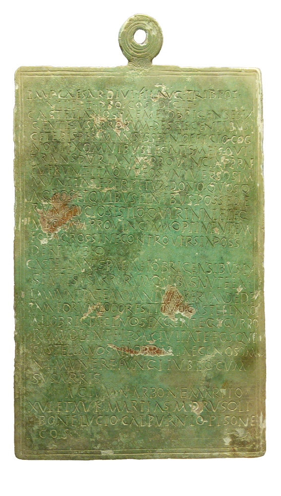
The Bierzo Edict, also referred to as the Edict of Augustus from El Bierzo and the Bembibre Bronze is a controversial document dated to 15 BC found in El Bierzo in Spain in 1999. The document is a bronze tablet measuring 24.15 cm x 15.6 cm. At the top it has a moulded 3 cm ring. The inscription contains the combined publication of two edicts by Augustus, one issued on 14 February and the other on 15 February. Text ::::''Imp(erator) · Caesar · Divi · fil(ius) · Aug(ustus) · trib(unicia) · pot(estate) ·'' ::::''VIIII · et · pro·co(n)s(ule) · dicit · Castellanos · Paemeiobrigenses'' ''· ex ·'' ::::''gente · Susarrorum'' ''· desciscentibus ·'' ::::''ceteris · permansisse · in officio · cog'' ::::''novi · ex omnibus · legatis · meis · qui ·'' ::::''Transdurianae · provinciae · prae/fuerunt · itaque · eos · universos · im'' ::::''munitate · perpetua · dono · quosq(ue)'' ::::''agros · et quibus · finibus · possede'' ::::''runt � ... [...More Info...] [...Related Items...] OR: [Wikipedia] [Google] [Baidu] |
El Bierzo
El Bierzo (; or ''El Bierzu''; ) is a '' comarca'' in the province of León, Spain. Its capital is the town of Ponferrada. Other major towns are Bembibre and Villafranca del Bierzo, the historical capital. The territory of El Bierzo includes most of the upper basin of the Sil river. It is surrounded by mountains on all sides, which makes this area remarkably isolated from all neighbouring lands. History In pre-Roman times the region was populated by the Astures, a Hispano-Celtic Gallaecian people. They were conquered by Emperor Augustus in the Astur-Cantabrian Wars (29–19 BC) and the area quickly became the largest mining center of the Empire during the Roman period, where gold and other metals and minerals were extracted. Numerous Roman mining sites are still visible in the area, one of the most spectacular being Las Médulas, a UNESCO World Heritage Site since 1997. Romans also imported grapevines, and wine production thrived in the region until the propagat ... [...More Info...] [...Related Items...] OR: [Wikipedia] [Google] [Baidu] |
List Of Municipalities Of El Bierzo ...
This is a list of the municipalities in the region of El Bierzo in the province of León, autonomous community of Castile and León, Spain. Image:El_Bierzo_-_Mapa_municipal.svg Image:Escudo de El Bierzo.svg See also *Geography of Spain *List of cities in Spain {{Municipalities of Spain Municipalities in El Bierzo El Bierzo El Bierzo (; or ''El Bierzu''; ) is a '' comarca'' in the province of León, Spain. Its capital is the town of Ponferrada. Other major towns are Bembibre and Villafranca del Bierzo, the historical capital. The territory of El Bierzo inclu ... [...More Info...] [...Related Items...] OR: [Wikipedia] [Google] [Baidu] |
List Of Postal Codes In Spain
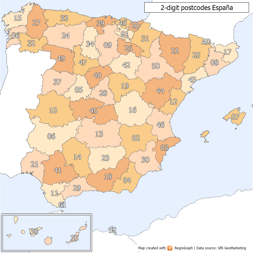
Spanish postal codes were introduced on 1 July 1984, when the introduced automated mail sorting. They consist of five numerical digits, where the first two digits, ranging 01 to 52, correspond either to one of the 50 provinces of Spain or to one of the two autonomous cities on the African coast. Two-digit prefixes The first two digits of a Spanish postal code identify the province or autonomous city it belongs to. The numbers were assigned to the 50 provinces of Spain ordered alphabetically at the time of implementation. The official names of some of the provinces have since changed, either to the regional language version of the name (e.g. from the Spanish to the Basque ) or to adopt the name of the autonomous community instead of the provincial capital (e.g. Santander to Cantabria). In these cases, the originally assigned code has been maintained, resulting in some exceptions to the alphabetical order. In addition, Ceuta and Melilla were originally included within the ... [...More Info...] [...Related Items...] OR: [Wikipedia] [Google] [Baidu] |
Province Of León
León (, ; ; ; ) is a province of northwestern Spain in the northern part of the Region of León and in the northwestern part of the autonomous community of Castile and León. About one quarter of its population of 463,746 (2018) lives in the capital, León. The climate is dry, cold in winter and hot in summer. This creates the perfect environment for wine and all types of cold meats and sausages like the leonese "Morcilla" and the "Cecina". There are two famous Roman Catholic cathedrals in the province, the main one in León and another in Astorga. The province shares the Picos de Europa National Park (in the Picos de Europa mountain range) with Cantabria and Asturias. It has 211 municipalities. History The province of León was established in 1833 with the new Spanish administrative organisation of regions and provinces to replace former kingdoms. The greater Leonese Region was composed of the provinces of León, Salamanca, Valladolid, Palencia and Zamora. The Kingd ... [...More Info...] [...Related Items...] OR: [Wikipedia] [Google] [Baidu] |
Instituto Nacional De Estadística (Spain)
The (INE; ) is the official government agency in Spain that collects statistics about demography, the economy, and Spanish society. It is an autonomous organization responsible for overall coordination of statistical services of the General State Administration in monitoring, control and supervision of technical procedures. Every 10 years, the institute conducts a national census. History First agency and evolution The oldest statistics agency of Spain and the predecessor of the current agency was the General Statistics Commission of the Kingdom, created on 3 November 1856 during the reign of Isabella II. The so-then Prime Minister Narváez approved a decree creating this body and ordering that people with recognized ability in this matter were part of it. On 1 May 1861 the Commission changed its name to General Statistics Board and their first work was to do a population census. By a decree of 12 September 1870 Prime Minister Serrano created the Geographic Institute a ... [...More Info...] [...Related Items...] OR: [Wikipedia] [Google] [Baidu] |
Census
A census (from Latin ''censere'', 'to assess') is the procedure of systematically acquiring, recording, and calculating population information about the members of a given Statistical population, population, usually displayed in the form of statistics. This term is used mostly in connection with Population and housing censuses by country, national population and housing censuses; other common censuses include Census of agriculture, censuses of agriculture, traditional culture, business, supplies, and traffic censuses. The United Nations (UN) defines the essential features of population and housing censuses as "individual enumeration, universality within a defined territory, simultaneity and defined periodicity", and recommends that population censuses be taken at least every ten years. UN recommendations also cover census topics to be collected, official definitions, classifications, and other useful information to coordinate international practices. The United Nations, UN's Food ... [...More Info...] [...Related Items...] OR: [Wikipedia] [Google] [Baidu] |
Cape Verde
Cape Verde or Cabo Verde, officially the Republic of Cabo Verde, is an island country and archipelagic state of West Africa in the central Atlantic Ocean, consisting of ten volcanic islands with a combined land area of about . These islands lie between west of Cap-Vert, the westernmost point of continental Africa. The List of islands of Cape Verde, Cape Verde islands form part of the Macaronesia ecoregion, along with the Azores, the Canary Islands, Madeira and the Savage Isles. The Cape Verde archipelago was uninhabited until the 15th century, when Portuguese Empire, Portuguese explorers colonized the islands, establishing one of the first Age of Discovery, European settlements in the tropics. Due to its strategic position, Cape Verde became a significant location in the Atlantic slave trade, transatlantic slave trade during the 16th and 17th centuries. The islands experienced economic growth during this period, driven by their role by the rapid emergence of merchants, priva ... [...More Info...] [...Related Items...] OR: [Wikipedia] [Google] [Baidu] |
Flag Of Cape Verde
The national flag of Cape Verde () was adopted on 22 September 1992, replacing the flag adopted during independence. Description The flag of Cape Verde has five unequal horizontal bands of blue, white, and red, with a circle of ten yellow five-pointed stars, all pointing upwards. The topmost blue stripe is half the height of the flag. Each of the three stripes of white and red are one twelfth of the height, and the bottom blue stripe is one quarter. Therefore, the height of the stripes are in a 6:1:1:1:3 ratio. The circle of stars is centered at of the height from the bottom (which corresponds to the center of the red stripe), and of the length from the hoist side. The lowest star is inscribed in an invisible circle centered at the middle of the lower blue stripe (that is, one eighth of the height from the bottom). The size of this invisible circle (which determines the size of the stars) is not specified by the constitution, but it is commonly constructed with a diameter equ ... [...More Info...] [...Related Items...] OR: [Wikipedia] [Google] [Baidu] |
São Domingos, Cape Verde
São Domingos (also: ''Várzea da Igreja'') is a cityCabo Verde, Statistical Yearbook 2015 Instituto Nacional de Estatística, p. 32-33 in the central part of the island of , . In 2010 its population was 2,818. It is the seat of the [...More Info...] [...Related Items...] OR: [Wikipedia] [Google] [Baidu] |


