|
Beaver Creek (Kentucky)
Beaver Creek is a stream in Floyd County, Kentucky, in the United States. It is located between the towns of Martin and Allen City. Some of the first white visitors to Floyd County camped on Beaver Creek in 1775. There are 6 branches that come off of the creek: Hunter Branch, Arkansas Creek, Lane Branch, Betsy Clark Branch, Eel Branch, and Hatcher Branch. Along Beaver Creek is Stumbo park. The park includes baseball fields, basketball courts, and recreational fire pits open to use of the public. The park also includes a 9-hole golf course. Water quality A biological assessment of the creek was taken in 2002 by the Kentucky Environmental and Public Protection Cabinet. 1 of the 28 samples taken from the creek was deemed suitable for full use. The other samples were deemed partially suitable. Coal mining is the main factor contributing to the poor water quality. There was a 5% decrease in surrounding forest in the watershed zone observed between 1994 and 2002. Additionally there ... [...More Info...] [...Related Items...] OR: [Wikipedia] [Google] [Baidu] |
Floyd County, Kentucky
Floyd County is a County (United States), county located in the U.S. state of Kentucky. As of the 2020 United States census, 2020 census, the population was 35,942. Its county seat is Prestonsburg, Kentucky, Prestonsburg. The county, founded in 1800, is named for Colonel (United States), Colonel James John Floyd, John Floyd (1750–1783). History On December 13, 1799, the Kentucky General Assembly passed legislation to form Floyd County as the 40th county of Kentucky.Kleber, John E. ''The Kentucky Encyclodpedia'' (University Press of Kentucky), p. 330 The county was made from parts of Fleming County, Kentucky, Fleming, Montgomery County, Kentucky, Montgomery, and Mason County, Kentucky. The legislation became effective on June 1, 1800. The county was named for James John Floyd, a pioneer surveyor who helped lay out the city of Louisville. The county seat was Preston's Station, later renamed Prestonsburg. The first court house burned down on April 8, 1808, destroying all the earl ... [...More Info...] [...Related Items...] OR: [Wikipedia] [Google] [Baidu] |
United States
The United States of America (USA), also known as the United States (U.S.) or America, is a country primarily located in North America. It is a federal republic of 50 U.S. state, states and a federal capital district, Washington, D.C. The 48 contiguous states border Canada to the north and Mexico to the south, with the semi-exclave of Alaska in the northwest and the archipelago of Hawaii in the Pacific Ocean. The United States asserts sovereignty over five Territories of the United States, major island territories and United States Minor Outlying Islands, various uninhabited islands in Oceania and the Caribbean. It is a megadiverse country, with the world's List of countries and dependencies by area, third-largest land area and List of countries and dependencies by population, third-largest population, exceeding 340 million. Its three Metropolitan statistical areas by population, largest metropolitan areas are New York metropolitan area, New York, Greater Los Angeles, Los Angel ... [...More Info...] [...Related Items...] OR: [Wikipedia] [Google] [Baidu] |
Coal Mining
Coal mining is the process of resource extraction, extracting coal from the ground or from a mine. Coal is valued for its Energy value of coal, energy content and since the 1880s has been widely used to Electricity generation, generate electricity. Steel and cement industries use coal as a fuel for extraction of iron from iron ore and for cement production. In the United Kingdom and South Africa, a coal mine and its structures are a colliery, a coal mine is called a "pit", and above-ground mining structures are referred to as a "pit head". In Australia, "colliery" generally refers to an underground coal mine. Coal mining has had many developments in recent years, from the early days of men tunneling, digging, and manually extracting the coal on carts to large Open-pit mining, open-cut and Longwall mining, longwall mines. Mining at this scale requires the use of Dragline excavator, draglines, trucks, conveyors, hydraulic jacks, and shearers. The coal mining industry has a long ... [...More Info...] [...Related Items...] OR: [Wikipedia] [Google] [Baidu] |
Water Quality
Water quality refers to the chemical, physical, and biological characteristics of water based on the standards of its usage. It is most frequently used by reference to a set of standards against which compliance, generally achieved through treatment of the water, can be assessed. The most common standards used to monitor and assess water quality convey the health of ecosystems, safety of human contact, extent of water pollution and condition of drinking water. Water quality has a significant impact on water supply and often determines supply options. Impacts on public health Over time, there has been increasing recognition of the importance of drinking water quality and its impact on public health. This has led to increasing protection and management of water quality. Text was copied from this source, which is available under a creativecommons:by/4.0/, Creative Commons Attribution 4.0 International License The understanding of the links between water quality and healt ... [...More Info...] [...Related Items...] OR: [Wikipedia] [Google] [Baidu] |
Drainage Basin
A drainage basin is an area of land in which all flowing surface water converges to a single point, such as a river mouth, or flows into another body of water, such as a lake or ocean. A basin is separated from adjacent basins by a perimeter, the drainage divide, made up of a succession of elevated features, such as ridges and hills. A basin may consist of smaller basins that merge at river confluences, forming a hierarchical pattern. Other terms for a drainage basin are catchment area, catchment basin, drainage area, river basin, water basin, and impluvium. In North America, they are commonly called a watershed, though in other English-speaking places, " watershed" is used only in its original sense, that of the drainage divide line. A drainage basin's boundaries are determined by watershed delineation, a common task in environmental engineering and science. In a closed drainage basin, or endorheic basin, rather than flowing to the ocean, water converges toward the ... [...More Info...] [...Related Items...] OR: [Wikipedia] [Google] [Baidu] |
Riparian Zone
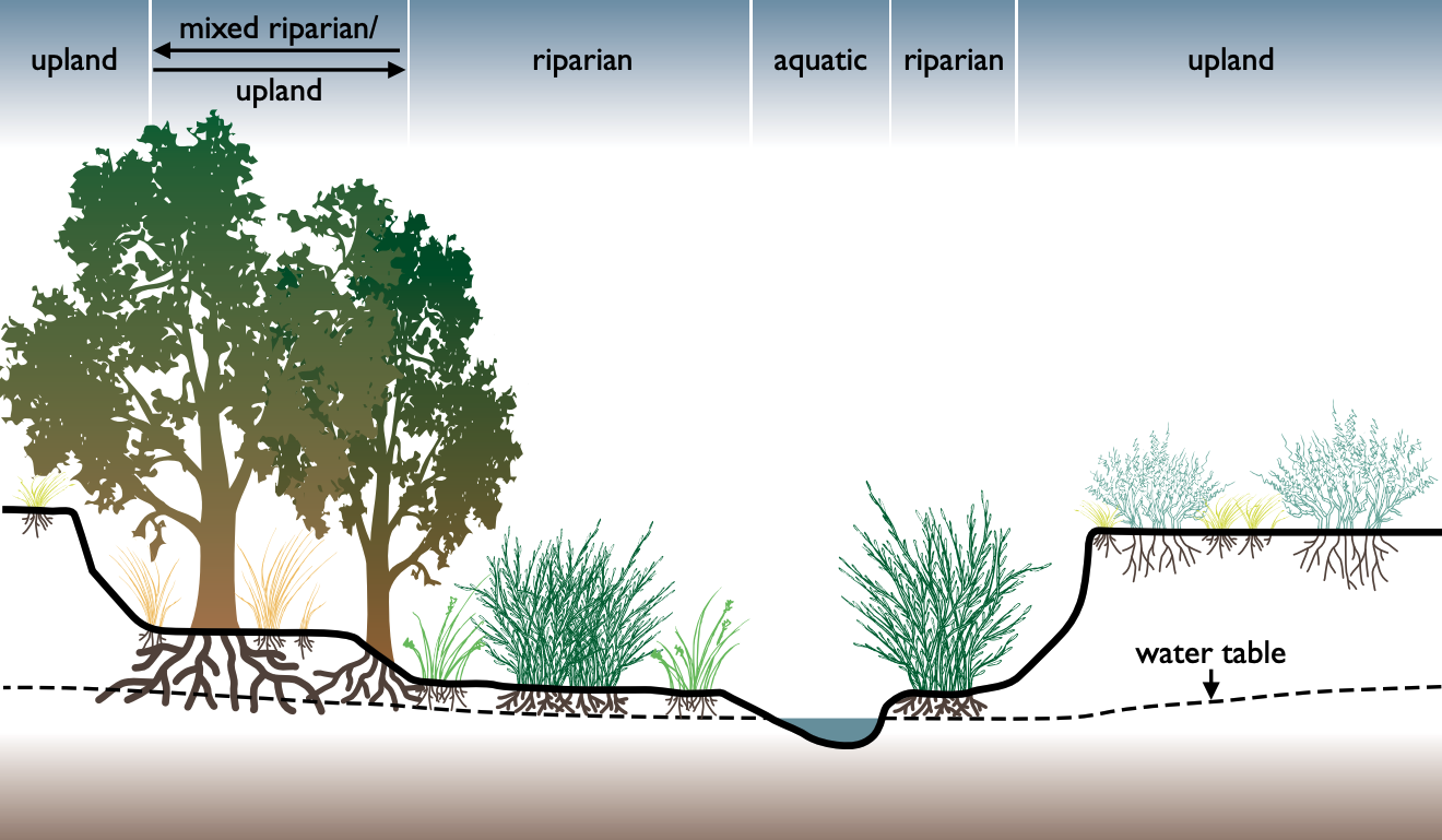
A riparian zone or riparian area is the interface between land and a river or stream. In some regions, the terms riparian woodland, riparian forest, riparian buffer zone, riparian corridor, and riparian strip are used to characterize a riparian zone. The word ''riparian'' is derived from Latin ''wiktionary:ripa, ripa'', meaning "bank (geography), river bank". Riparian is also the proper nomenclature for one of the terrestrial biomes of the Earth. Plant habitats and communities along the river margins and banks are called riparian vegetation, characterized by aquatic plant, hydrophilic plants. Riparian zones are important in ecology, environmental resource management, and civil engineering because of their role in soil conservation, their habitat biodiversity, and the influence they have on terrestrial animal, terrestrial and semiaquatic fauna as well as aquatic ecosystems, including grasslands, woodlands, wetlands, and even non-vegetative areas. Riparian zones may be natural ... [...More Info...] [...Related Items...] OR: [Wikipedia] [Google] [Baidu] |
Thomas Walker (explorer)
Thomas Walker (January 25, 1715 – November 9, 1794) was a physician, Planter class, planter and explorer in Colony of Virginia, colonial Virginia who served multiple terms in the Virginia General Assembly, and whose descendants also had political careers. Walker explored the Western Colony of Virginia (present-day Kentucky) in 1750, a full 19 years before the arrival of famed frontiersman Daniel Boone. Early life Thomas Walker was born at "Rye Field", Walkerton, Virginia, Walkerton, King and Queen County, Virginia. He was raised as an Englishman in the Tidewater (region), Tidewater region of Virginia. Walker's first profession was that of a physician; he had attended the College of William & Mary and studied under his brother-in-law George Gilmer, Sr., Dr. George Gilmer. Walker married Mildred Thornton (widow of Nicholas Meriwether) in 1741, and acquired land and owned enslaved people in the soon-to be formed Albemarle County from her late husband's estate. The couple built a ... [...More Info...] [...Related Items...] OR: [Wikipedia] [Google] [Baidu] |
Coal Mining In Kentucky
Coal was discovered in Kentucky in 1750. Since the first commercial coal mine opened in 1820 coal has gained both economic importance and controversy regarding its environmental consequences. As of 2010 there were 442 operating coal mines in the state, and as of 2017 there were fewer than 4,000 underground coalminers. History Just two years after the first coal was discovered in the United States in 1750 explorer Thomas Walker (explorer), Thomas Walker discovered coal in what would become Kentucky and used it to heat his camp fire. Although his discovery came in the Eastern Coalfield it would be another 150 years before commercial coal production occurred there. In 1820 the first commercial coal mine in Kentucky opened in the Western Coalfield in Muhlenberg County. In its first year the mine produced 328 tons of coal. By 1843 the state produced 100,000 tons of coal, and by 1879 the state produced one million tons of coal, all coming from the Western Coalfield. In 1900 the first ... [...More Info...] [...Related Items...] OR: [Wikipedia] [Google] [Baidu] |
List Of Rivers Of Kentucky
List of rivers in Kentucky (U.S. state). By drainage basin This list is arranged by drainage basin, with respective tributaries indented under each larger stream's name. All rivers in Kentucky flow to the Mississippi River, nearly all by virtue of flowing to its major tributary, the Ohio River. Also listed are some important tributaries to the few Kentucky rivers that originate in, or flow through, other states. *Mississippi River ** Obion Creek ** Mayfield Creek **Ohio River *** Goose Creek *** Massac Creek ***Tennessee River **** Clarks River **** Blood River ***Cumberland River **** Little River **** Red River **** Obey River (Tennessee) ***** Wolf River **** Big South Fork of the Cumberland River ****Rockcastle River ****Laurel River **** Clear Fork *** Tradewater River *** Green River **** Panther Creek **** Pond River **** Rough River **** Mud River **** Barren River ***** Gasper River **** Little Reedy Creek **** Big Reedy Creek **** Bear Creek **** Nolin River **** Litt ... [...More Info...] [...Related Items...] OR: [Wikipedia] [Google] [Baidu] |
Rivers Of Floyd County, Kentucky
A river is a natural stream of fresh water that flows on land or inside Subterranean river, caves towards another body of water at a lower elevation, such as an ocean, lake, or another river. A river may run dry before reaching the end of its course if it runs out of water, or only flow during certain seasons. Rivers are regulated by the water cycle, the processes by which water moves around the Earth. Water first enters rivers through precipitation, whether from rainfall, the Runoff (hydrology), runoff of water down a slope, the melting of glaciers or snow, or seepage from aquifers beneath the surface of the Earth. Rivers flow in channeled watercourses and merge in confluences to form drainage basins, or catchments, areas where surface water eventually flows to a common outlet. Rivers have a great effect on the landscape around them. They may regularly overflow their Bank (geography), banks and flood the surrounding area, spreading nutrients to the surrounding area. Sedime ... [...More Info...] [...Related Items...] OR: [Wikipedia] [Google] [Baidu] |


