|
Beaufort Sea
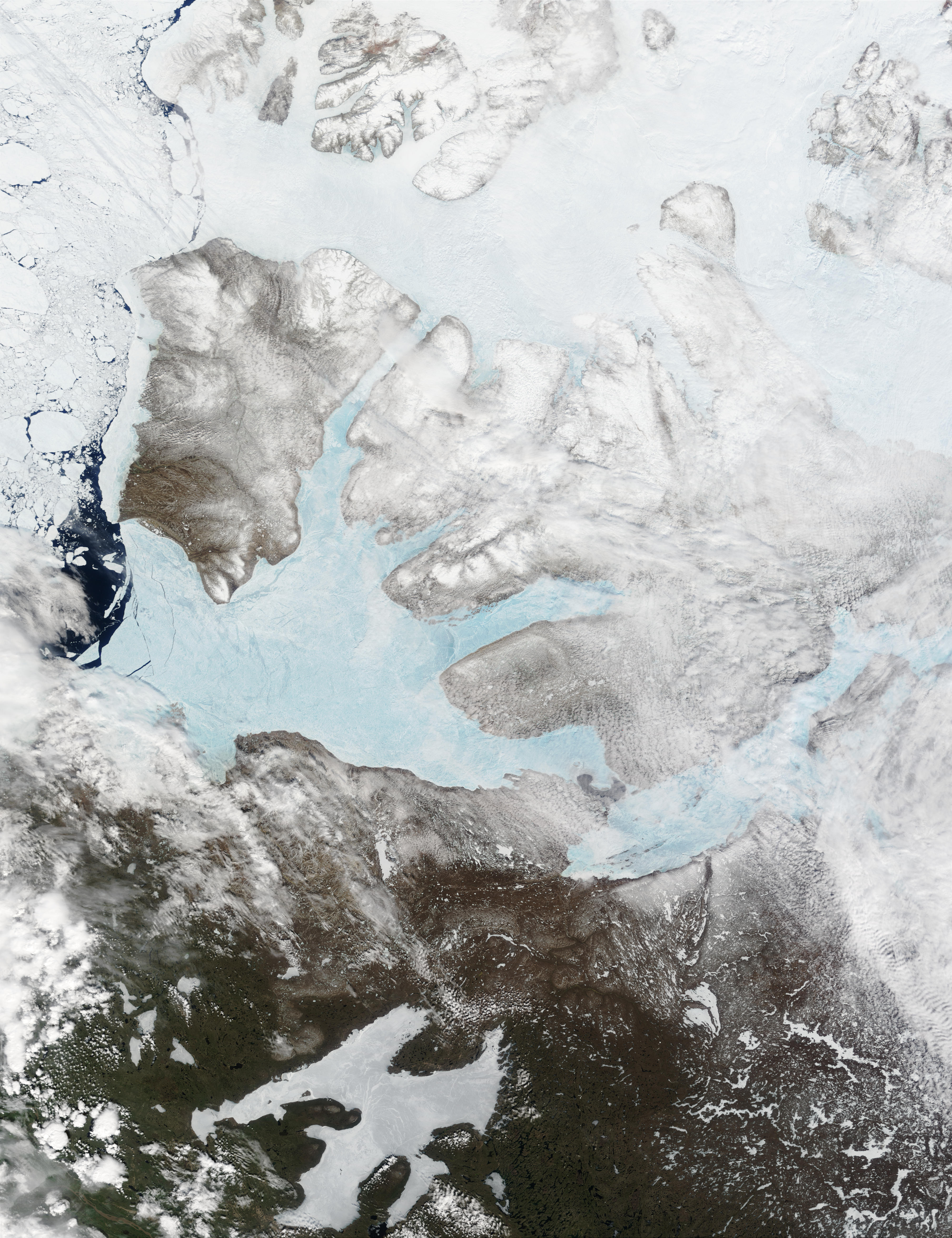
The Beaufort Sea ( ; ) is a marginal sea of the Arctic Ocean, located north of the Northwest Territories, Yukon, and Alaska, and west of the Canadian Arctic Archipelago. The sea is named after Sir Francis Beaufort, a Hydrography, hydrographer. The Mackenzie River, the longest in Canada, empties into the Canadian part of the Beaufort Sea west of Tuktoyaktuk, which is one of the few permanent settlements on the sea's shores. The sea, characterized by severe climate, is frozen over most of the year. Historically, only a narrow pass up to opened in August–September near its shores, but recently due to climate change in the Arctic the ice-free area in late summer has greatly enlarged. Until recently, the Beaufort Sea was known as an important reservoir for the replenishment of Arctic sea ice. Sea ice would often rotate for several years in the Beaufort Gyre, the dominant ocean current of the Beaufort Sea, growing into sturdy and thick multi-year ice. Claims that the seacoast was p ... [...More Info...] [...Related Items...] OR: [Wikipedia] [Google] [Baidu] |
Great Soviet Encyclopedia
The ''Great Soviet Encyclopedia'' (GSE; , ''BSE'') is one of the largest Russian-language encyclopedias, published in the Soviet Union from 1926 to 1990. After 2002, the encyclopedia's data was partially included into the later ''Great Russian Encyclopedia'' in an updated and revised form. The GSE claimed to be "the first Marxist–Leninist general-purpose encyclopedia". Origins The idea of the ''Great Soviet Encyclopedia'' emerged in 1923 on the initiative of Otto Schmidt, a member of the Russian Academy of Sciences. In early 1924 Schmidt worked with a group which included Mikhail Pokrovsky, (rector of the Institute of Red Professors), Nikolai Meshcheryakov (Former head of the General Directorate for the Protection of State Secrets in the Press, Glavit, the State Administration of Publishing Affairs), Valery Bryusov (poet), Veniamin Kagan (mathematician) and Konstantin Kuzminsky to draw up a proposal which was agreed to in April 1924. Also involved was Anatoly Lunacharsky, People' ... [...More Info...] [...Related Items...] OR: [Wikipedia] [Google] [Baidu] |
Inuvialuit
The Inuvialuit (sing. Inuvialuk; ''the real people'') or Western Canadian Inuit are Inuit who live in the western Canadian Arctic region. They, like all other Inuit, are descendants of the Thule who migrated eastward from Alaska. Their homeland – the Inuvialuit Settlement Region – covers the Arctic Ocean coastline area from the Alaskan border, east through the Beaufort Sea and beyond the Amundsen Gulf which includes some of the western Canadian Arctic Islands, as well as the inland community of Aklavik and part of Yukon. The land was demarked in 1984 by the Inuvialuit Final Agreement. History and migration The Inuvialuit Settlement Region was primarily inhabited by ''Siglit'' Inuit until their numbers were decimated by the introduction of new diseases in the second half of the 19th century. Nunamiut, Alaskan Iñupiat, moved into traditional Siglit areas in the 1910s and 20s, enticed in part by renewed demand for furs from the Hudson's Bay Company and European market ... [...More Info...] [...Related Items...] OR: [Wikipedia] [Google] [Baidu] |
Banks Island
Banks Island is one of the larger members of the Arctic Archipelago. Situated in the Inuvik Region, and part of the Inuvialuit Settlement Region, of the Northwest Territories, it is separated from Victoria Island to its east by the Prince of Wales Strait and from the mainland by Amundsen Gulf to its south. The Beaufort Sea lies to its west, and to its northeast M'Clure Strait separates the island from Prince Patrick Island and Melville Island. It is home to at least fourteen mammal species including the Peary caribou, barren-ground caribou, and polar bears. At one time over 68,000 muskoxen lived on the island, the majority of the world's population. However, the bacterium '' Erysipelothrix rhusiopathiae'' has led to a sharp decline in their numbers. The island is the summer home to hundreds of thousands of migratory birds who nest at Banks Island Migratory Bird Sanctuary No. 1 and Banks Island Migratory Bird Sanctuary No. 2. As of the 2016 census it had a human populati ... [...More Info...] [...Related Items...] OR: [Wikipedia] [Google] [Baidu] |
Prince Patrick Island
A member of the Arctic Archipelago, Prince Patrick Island is the westernmost of the Queen Elizabeth Islands in the Northwest Territories of Canada, lying northwest of Melville Island (Northwest Territories and Nunavut), Melville Island. The area of Prince Patrick Island is , making it the List of islands by area, 55th largest island in the world and List of Canadian islands by area, Canada's 14th largest island. It has historically been fast ice, icebound all year, making it one of the least accessible parts of Canada. Located at the entrance of the M'Clure Strait, Prince Patrick Island is uninhabited. The first known sighting of the island was in 1853 by the Irish naval officer George Mecham, when it was explored by him and his fellow Irish explorer Francis Leopold McClintock in the spring of that year during the Edward Belcher expedition. Much later, it was named for Prince Arthur, Duke of Connaught and Strathearn, Prince Arthur William Patrick, Duke of Connaught and Strathearn ... [...More Info...] [...Related Items...] OR: [Wikipedia] [Google] [Baidu] |
Point Barrow
Point Barrow or Nuvuk is a headland on the Arctic coast in the U.S. state of Alaska, northeast of Utqiagvik (formerly Barrow). It is the northernmost point of all the territory of the United States, at , south of the North Pole. (The northernmost point on the North American mainland, Murchison Promontory in Canada, is farther north.) Geography Point Barrow is an important geographical landmark, marking the limit between two marginal seas of the Arctic Ocean, the Chukchi Sea to the west and the Beaufort Sea to the east. History Archaeological evidence indicates that Point Barrow was occupied by the ancestors of the Iñupiat for almost 1,000 years prior to the arrival of the first Europeans. Occupation continued into the 1940s. The headland is an important archaeological site, yielding burials and artifacts associated with the Thule culture, including uluit and bola. The waters off Point Barrow are on the bowhead whale migration route and it is surmised, that the site ... [...More Info...] [...Related Items...] OR: [Wikipedia] [Google] [Baidu] |
International Hydrographic Organization
The International Hydrographic Organization (IHO) (French: ''Organisation Hydrographique Internationale'') is an intergovernmental organization representing hydrography. the IHO comprised 102 member states. A principal aim of the IHO is to ensure that the world's seas, oceans and navigable waters are properly surveyed and charted. It does this through the setting of international standards and through its capacity building programs and offices. The IHO enjoys observer status at the United Nations, where it is the recognized competent authority on hydrographic surveying and nautical charting. When referring to hydrography and nautical charting in conventions and similar instruments, it is the IHO standards and specifications that are normally used. History During the 19th century, many maritime nations established hydrographic offices to provide means for improving the navigation of naval and merchant vessels by providing nautical publications, nautical charts, and oth ... [...More Info...] [...Related Items...] OR: [Wikipedia] [Google] [Baidu] |
Sea Ice Retreat In The Beaufort Sea - Flickr - NASA Goddard Photo And Video
A sea is a large body of salt water. There are particular seas and the sea. The sea commonly refers to the ocean, the interconnected body of seawaters that spans most of Earth. Particular seas are either marginal seas, second-order sections of the oceanic sea (e.g. the Mediterranean Sea), or certain large, nearly landlocked bodies of water. The salinity of water bodies varies widely, being lower near the surface and the mouths of large rivers and higher in the depths of the ocean; however, the relative proportions of dissolved salts vary little across the oceans. The most abundant solid dissolved in seawater is sodium chloride. The water also contains salts of magnesium, calcium, potassium, and mercury, among other elements, some in minute concentrations. A wide variety of organisms, including bacteria, protists, algae, plants, fungi, and animals live in various marine habitats and ecosystems throughout the seas. These range vertically from the sunlit surface and shoreline ... [...More Info...] [...Related Items...] OR: [Wikipedia] [Google] [Baidu] |
NOAA Arctic Spring 1950 Corp1104-2
The National Oceanic and Atmospheric Administration (NOAA ) is an American scientific and regulatory agency charged with forecasting weather, monitoring oceanic and atmospheric conditions, charting the seas, conducting deep-sea exploration, and managing fishing and protection of marine mammals and endangered species in the US exclusive economic zone. The agency is part of the United States Department of Commerce and is headquartered in Silver Spring, Maryland. History NOAA traces its history back to multiple agencies, some of which are among the earliest in the federal government: * United States Coast and Geodetic Survey, formed in 1807 * Weather Bureau of the United States, formed in 1870 * Bureau of Commercial Fisheries, formed in 1871 (research fleet only) * Coast and Geodetic Survey Corps, formed in 1917 The most direct predecessor of NOAA was the Environmental Science Services Administration (ESSA), into which several existing scientific agencies such as the Uni ... [...More Info...] [...Related Items...] OR: [Wikipedia] [Google] [Baidu] |
Inuvialuit Settlement Region
The Inuvialuit Settlement Region, abbreviated as ISR (; ), located in Canada's western Arctic, was designated in 1984 in the Inuvialuit Final Agreement by the Government of Canada for the Inuvialuit (''the real people''). It spans , including of land and of subsurface mineral rights. The ISR is mainly above the tree line, and includes several sub-regions: the Beaufort Sea, the Mackenzie River delta, the northern portion of Yukon ("Yukon North Slope", Herschel Island), and the northwest portion of the Northwest Territories. The ISR includes both Crown Lands and Inuvialuit Private Lands. Most of the ISR is represented by Nunakput, the territorial electoral district, meaning "our land" in Inuvialuktun. The ISR is one of the four Inuit regions of Canada, collectively known as Inuit Nunangat, represented by the Inuit Tapiriit Kanatami (ITK). The other regions include Nunatsiavut in Labrador, Nunavik in northern Quebec, and the territory of Nunavut. The ISR is the homeland of ... [...More Info...] [...Related Items...] OR: [Wikipedia] [Google] [Baidu] |
HuffPost
''HuffPost'' (''The Huffington Post'' until 2017, itself often abbreviated as ''HPo'') is an American progressive news website, with localized and international editions. The site offers news, satire, blogs, and original content, and covers politics, business, entertainment, environment, technology, popular media, lifestyle, culture, comedy, healthy eating, young women's interests, and local news featuring columnists. It was created to provide a progressive alternative to conservative news websites such as the Drudge Report. The site contains its own content and user-generated content via video blogging, audio, and photo. In 2012, the website became the first commercially run United States digital media enterprise to win a Pulitzer Prize. Founded by Arianna Huffington, Andrew Breitbart, Kenneth Lerer, and Jonah Peretti, the site was launched on May 9, 2005, as a counterpart to the Drudge Report. In March 2011, it was acquired by AOL for US$315 million, with Arianna ... [...More Info...] [...Related Items...] OR: [Wikipedia] [Google] [Baidu] |
Amundsen Gulf
Amundsen Gulf is a gulf located mainly in the Inuvik Region, Northwest Territories, Canada with a small section in the Kitikmeot Region of Nunavut. It lies between Banks Island and Victoria Island (Canada), Victoria Island and the mainland. It is approximately in length and about across where it meets the Beaufort Sea. The Amundsen Gulf was explored by Norwegian explorer Roald Amundsen between 1903 and 1906. The gulf is at the western end of the famous Northwest Passage, a route from the Atlantic Ocean to the Pacific Ocean, Pacific. Few people live along the shores of the gulf, but there are a few towns and communities, including Sachs Harbour, Ulukhaktok, and Paulatuk. Heading north in the gulf one would find the Prince of Wales Strait. Heading southeast and east, the gulf leads through the Dolphin and Union Strait, past Simpson Bay and into the Coronation Gulf. From there one would go through the Dease Strait and into the Queen Maud Gulf, and eventually head northeast into ... [...More Info...] [...Related Items...] OR: [Wikipedia] [Google] [Baidu] |


