|
Babadaýhan
Babadaýhan (from Persian بابادهقان ''Bâbâdehqân/Bābā-Dihqān'') is a city and capital of Babadaýhan District in the Ahal Province of Turkmenistan. During the Soviet period, it was named Kirovsk in honor of Sergei Kirov Sergei Mironovich Kirov (born Kostrikov; 27 March 1886 – 1 December 1934) was a Russian and Soviet politician and Bolsheviks, Bolshevik revolutionary. Kirov was an early revolutionary in the Russian Empire and a member of the Bolshevik faction .... Its name and the name of the surrounding district were changed on 26 June 1992 by Parliamentary Resolution No. 729-XII. Populated places in Ahal Region {{Cities of Turkmenistan ... [...More Info...] [...Related Items...] OR: [Wikipedia] [Google] [Baidu] |
Babadaýhan District
Babadaýhan District (, Бабадайхан этрабы) is a district of Ahal Province, Turkmenistan. From the Soviet period until 1992, the settlement was named in honor of Sergei Kirov. On 26 June 1992, by Parliamentary Resolution No. 729-XII, Kirov District and its capital were renamed Babadaýhan. The name Babadaýhan is the Turkmenized form of the Persian name Bābā-Dihqān (بابادهقان), which eans “Forefather Farmer”, a mythological and ritual character whose cult has been reported in agrarian communities of mountainous and lowland Tajikistan, North Afghanistan and adjacent rural areas of Uzbekistan, Turkmenistan, and Kazakhstan. As an Iranian mythological figure, Bābā-ye Dehqān is believed to be the first man and the first farmer who taught his profession to mankind through a chain of his successors.Krasnowolska, AnnaBĀBĀ-YE DEHQĀN in Encyclopaedia Iranica, 2009. Administrative Subdivisions * Cities (şäherler) ** Babadaýhan Babadaýhan (from Per ... [...More Info...] [...Related Items...] OR: [Wikipedia] [Google] [Baidu] |
Ahal Province
Ahal Region (; from , also ) is one of five provinces of Turkmenistan. It is in the south-center of the country, bordering Iran and Afghanistan along the Kopet Dag Range. Its area is and population 886,845 (2022 census).''Statistical Yearbook of Turkmenistan 2000–2004'', National Institute of State Statistics and Information of Turkmenistan, Ashgabat, 2005. Overview In 2000, Ahal Region accounted for 14% of Turkmenistan's population, 11% of the total number of employed, 23% of agricultural production (by value), and 31% of the country's total industrial production. Ahal's agriculture is irrigated by the Karakum Canal, which stretches all the way across the province from east to west, tracking Turkmenistan's southern border. Another water source is the Tejen River, which flows north from Afghanistan in the southeast corner of the province, passing through two large reservoirs south of the city of Tejen. Ahal is known for the Battle of Geok Tepe of 1881, today the site of ... [...More Info...] [...Related Items...] OR: [Wikipedia] [Google] [Baidu] |
Districts Of Turkmenistan
The districts of Turkmenistan (, sing. ''etrap'') are territorial entities below the regions of Turkmenistan, provinces of Turkmenistan (, sing. ''Wilayah, welaýat''). They may be counties, cities, or boroughs of cities. The heads of the districts (, translated as "governor" for districts of a ''welaýat'' and "mayor" for cities or boroughs of a city) are appointed by the President of Turkmenistan (Constitution of Turkmenistan, Articles 80-81). Regarding cities "with district status" (), by Turkmen law, "...such cities must have population over 30,000 and be the administrative center of a province (welaýat); headed by a presidentially appointed häkim." Though this officially limits the possible number of such cities to five (the number of provinces), in reality other cities are periodically accorded the status of a district. As of 9 November 2022, 7 cities in Turkmenistan enjoyed the status of districts. One city, the capital city of Ashgabat, enjoys the status of a provin ... [...More Info...] [...Related Items...] OR: [Wikipedia] [Google] [Baidu] |
Countries Of The World
The following is a list providing an overview of sovereign states around the world with information on their status and recognition of their sovereignty. The 205 listed states can be divided into three categories based on membership within the United Nations System: 193 member states of the United Nations, UN member states, two United Nations General Assembly observers#Current non-member observers, UN General Assembly non-member observer states, and ten other states. The ''sovereignty dispute'' column indicates states having undisputed sovereignty (188 states, of which there are 187 UN member states and one UN General Assembly non-member observer state), states having disputed sovereignty (15 states, of which there are six UN member states, one UN General Assembly non-member observer state, and eight de facto states), and states having a political status of the Cook Islands and Niue, special political status (two states, both in associated state, free association with New ... [...More Info...] [...Related Items...] OR: [Wikipedia] [Google] [Baidu] |
Provinces Of Turkmenistan
Turkmenistan is divided into five regions, or ''welaýatlar'' (singular '' welaýat'') and one capital city (''şäher'') with provincial legal status. They are Ahal, Balkan, Dashoguz, Lebap and Mary, plus the capital city of Ashgabat. Each province is divided into districts. As of 20 December 2022 there were 37 districts (), 49 cities (), including 7 cities with district status (), 68 towns (), 469 rural councils (rural municipal units, ) and 1690 villages (rural settlements ) in Turkmenistan. The regions are also translated as ''oblasts'', which were also the administrative divisions of the Turkmen Soviet Socialist Republic, a republic of the Soviet Union, which retained the system after independence in 1991. Capital city The capital city of Turkmenistan is Ashgabat, which is an administrative and territorial unit with provincial authorities. ''See also'Map of the Boroughs of Ashgabat As of January 5, 2018, Ashgabat includes four boroughs (''uly etraplar''), each with ... [...More Info...] [...Related Items...] OR: [Wikipedia] [Google] [Baidu] |
Flag Of Turkmenistan
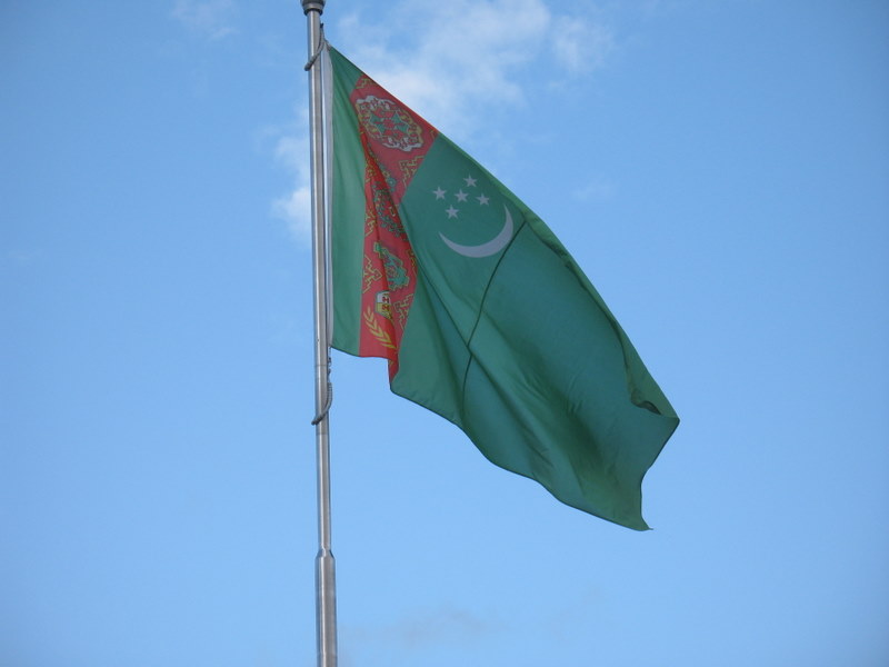
The national flag of Turkmenistan () features a white crescent and five stars representing the five regions of the country and the Five Pillars of Islam. Placed upon a green field is a symbolic representation of the country's famous carpet industry. It was introduced as the flag of Turkmenistan on 27 September 1992 to replace the Soviet-era flag. The modified version with a 2:3 ratio was adopted on 24 January 2001. State Flag and Constitution Day is celebrated on 18 May. Design Description The flag features a green field with a vertical red stripe on the hoist side, containing five carpet guls (designs used in producing rugs) stacked above two crossed olive branches similar to those on the flag of the United Nations. A white crescent moon and five white five-pointed stars appear as a charge on the fly side of the red stripe. Colors Symbolism While no official explanation has been given for the symbolism of the flag's colors or white symbols, there are several leading ... [...More Info...] [...Related Items...] OR: [Wikipedia] [Google] [Baidu] |
Turkmenistan
Turkmenistan is a landlocked country in Central Asia bordered by Kazakhstan to the northwest, Uzbekistan to the north, east and northeast, Afghanistan to the southeast, Iran to the south and southwest and the Caspian Sea to the west. Ashgabat is the capital and largest city. It is one of the six independent Turkic states. With a population over 7 million, Turkmenistan is the 35th most-populous country in Asia and has the lowest population of the Central Asian republics while being one of the most sparsely populated nations on the Asian continent. Turkmenistan has long served as a thoroughfare for several empires and cultures. Merv is one of the oldest oasis-cities in Central Asia, and was once among the biggest cities in the world. It was also one of the great cities of the Islamic world and an important stop on the Silk Road. Annexed by the Russian Empire in 1881, Turkmenistan figured prominently in the anti-Bolshevik movement in Central Asia. In 1925, Turkmenistan be ... [...More Info...] [...Related Items...] OR: [Wikipedia] [Google] [Baidu] |
Persian Language
Persian ( ), also known by its endonym and exonym, endonym Farsi (, Fārsī ), is a Western Iranian languages, Western Iranian language belonging to the Iranian languages, Iranian branch of the Indo-Iranian languages, Indo-Iranian subdivision of the Indo-European languages. Persian is a pluricentric language predominantly spoken and used officially within Iran, Afghanistan, and Tajikistan in three mutual intelligibility, mutually intelligible standard language, standard varieties, respectively Iranian Persian (officially known as ''Persian''), Dari, Dari Persian (officially known as ''Dari'' since 1964), and Tajik language, Tajiki Persian (officially known as ''Tajik'' since 1999).Siddikzoda, S. "Tajik Language: Farsi or not Farsi?" in ''Media Insight Central Asia #27'', August 2002. It is also spoken natively in the Tajik variety by a significant population within Uzbekistan, as well as within other regions with a Persianate society, Persianate history in the cultural sphere o ... [...More Info...] [...Related Items...] OR: [Wikipedia] [Google] [Baidu] |
City
A city is a human settlement of a substantial size. The term "city" has different meanings around the world and in some places the settlement can be very small. Even where the term is limited to larger settlements, there is no universally agreed definition of the lower boundary for their size. In a narrower sense, a city can be defined as a permanent and Urban density, densely populated place with administratively defined boundaries whose members work primarily on non-agricultural tasks. Cities generally have extensive systems for housing, transportation, sanitation, Public utilities, utilities, land use, Manufacturing, production of goods, and communication. Their density facilitates interaction between people, government organisations, government organizations, and businesses, sometimes benefiting different parties in the process, such as improving the efficiency of goods and service distribution. Historically, city dwellers have been a small proportion of humanity overall, bu ... [...More Info...] [...Related Items...] OR: [Wikipedia] [Google] [Baidu] |
Soviet Union
The Union of Soviet Socialist Republics. (USSR), commonly known as the Soviet Union, was a List of former transcontinental countries#Since 1700, transcontinental country that spanned much of Eurasia from 1922 until Dissolution of the Soviet Union, it dissolved in 1991. During its existence, it was the list of countries and dependencies by area, largest country by area, extending across Time in Russia, eleven time zones and sharing Geography of the Soviet Union#Borders and neighbors, borders with twelve countries, and the List of countries and dependencies by population, third-most populous country. An overall successor to the Russian Empire, it was nominally organized as a federal union of Republics of the Soviet Union, national republics, the largest and most populous of which was the Russian SFSR. In practice, Government of the Soviet Union, its government and Economy of the Soviet Union, economy were Soviet-type economic planning, highly centralized. As a one-party state go ... [...More Info...] [...Related Items...] OR: [Wikipedia] [Google] [Baidu] |
Sergei Kirov
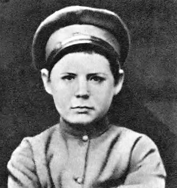
Sergei Mironovich Kirov (born Kostrikov; 27 March 1886 – 1 December 1934) was a Russian and Soviet politician and Bolsheviks, Bolshevik revolutionary. Kirov was an early revolutionary in the Russian Empire and a member of the Bolshevik faction of the Russian Social Democratic Labour Party. Kirov became an Old Bolshevik and personal friend to Joseph Stalin, rising through the Communist Party of the Soviet Union ranks to become head of the party in Leningrad and a member of the Politburo of the Communist Party of the Soviet Union, Politburo. On 1 December 1934, Kirov was shot and killed by Leonid Nikolaev at his offices in the Smolny Institute. Nikolaev and several alleged accomplices were convicted in a show trial and capital punishment, executed less than 30 days later. Kirov's assassination was used by Stalin as a reason for starting the Moscow trials and the Great Purge. Early life Sergei Mironovich Kostrikov was born on in Urzhum, Urzhumsky District, Kirov Oblast, Urzh ... [...More Info...] [...Related Items...] OR: [Wikipedia] [Google] [Baidu] |


