|
Ayninbirkekin
Ayninbirkekin is a ''tabia'' or municipality in the Dogu'a Tembien district of the Tigray Region of Ethiopia. Literal meaning of Ayninbirkekin in Tigrinya is "We will not bend". The ''tabia'' centre is in Halah village, located approximately 8 km to the east of the ''woreda'' town Hagere Selam. Main town is Ala'isa, situated on the ridge overseeing the Giba valley. Geography The ''tabia'' is located astride a main water divide (that is followed by the main road) and stretches down towards May Zegzeg river at the south and upper Tsaliet River at the north. Three highest places (at around 2600 m a.s.l.) are Meri’a Ziban in the west, Imba Ra’isot in the centre and the escarpment to Arebay at the north. The lowest places are the confluence of May Zegzeg and May Be’ati Rivers (1970 m a.s.l.) in the south and in the north May Leiba River near Iyesus church (2240 m a.s.l.). Geology From the higher to the lower locations, the following geological form ... [...More Info...] [...Related Items...] OR: [Wikipedia] [Google] [Baidu] |
Degua Tembien
Dogu'a Tembien (, "Upper Tembien", sometimes transliterated as Degua Tembien) is a woreda in Tigray Region, Ethiopia. It is named in part after the former province of Tembien. Nowadays, the mountainous district is part of the Southeastern Tigray Zone. The administrative centre of this woreda is Hagere Selam. History Dogu’a Tembien holds numerous prehistoric sites, which have been dated to the Middle Stone Age in Ayninbirkekin, or Pastoral Neolithic in Aregen and Menachek. Geography Topography and landscapes Major mountains :* Tsatsen, 2815 metres, a wide mesa between Hagere Selam and Inda Maryam Qorar () :* Ekli Imba, 2799 metres, summit of the Arebay massif in Arebay ''tabia'' or district () :* Imba Zuw’ala, 2710 metres, near Hagere Selam () :* Aregen, 2660 metres, in Aregen ''tabia'' () :* Dabba Selama, 2630 metres, in Haddinnet ''tabia'' () (not to be confused with the homonymous monastery) :* Imba Dogu’a, 2610 metres, in Mizane Birhan ''tabia'' () :* I ... [...More Info...] [...Related Items...] OR: [Wikipedia] [Google] [Baidu] |
Arebay
Arebay is a ''tabia'' or municipality in the Dogu'a Tembien district of the Tigray Region of Ethiopia organised around the Arebay mountain peaks (2799 m). The ''tabia'' centre is in Arebay village, located approximately 13 km to the east-northeast of the ''woreda'' town Hagere Selam. Geography The ''tabia'' occupies a high position around the Arebay peaks Ekli Imba, Medayq and Addi Shumbolo. The highest peak is 2799 m a.s.l. and the lowest place at the northeast (2150 m a.s.l.). Geology and soils Geological formations From the higher to the lower locations, the following geological formations are present: * Upper basalt * Interbedded lacustrine deposits * Lower basalt * Amba Aradam Formation * Agula Shale * Mekelle Dolerite Soil types From Ekli Imba down to the cliff that marks the boundary to Ayninbirkekin, “red-black” Skeletic Cambisol–Pellic Vertisol catenas occur on basalt. Climate The rainfall pattern shows a very high seasonality with 70 ... [...More Info...] [...Related Items...] OR: [Wikipedia] [Google] [Baidu] |
May Zegzeg
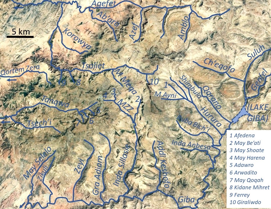
May Zegzeg is a river of the Nile basin. Rising in the mountains of Dogu’a Tembien in northern Ethiopia, it flows southward to empty finally in Giba and Tekezé River. Characteristics It is a confined river, locally meandering in its narrow alluvial plain, with an average slope gradient of 43 metres per kilometre. With its tributaries May Sho'ate and May Harena, the river has cut a gorge. Jointly with adjacent May Be’ati River, this river is the source of Rubaksa River. Flash floods and flood buffering Runoff mostly happens in the form of high runoff discharge events that occur in a very short period (called flash floods). These are related to the steep topography, often little vegetation cover and intense convective rainfall. The peaks of such flash floods have often a 50 to 100 times larger discharge than the preceding baseflow. The magnitude of floods in this river has however been decreased due to interventions in the catchment. At Habdi Luqmuts and on other stee ... [...More Info...] [...Related Items...] OR: [Wikipedia] [Google] [Baidu] |
Tsaliet
Tsaliet is a river in northern Ethiopia, belonging to the Nile basin. Rising in the mountains of Dogu’a Tembien, where it is first called May Leiba River and then Tinsehe River, it flows westward through a deep gorge, to become Tsaliet in its lower course, where it empties in Weri’i River, just upstream of the main Weri’i bridge along the road to Adwa. Characteristics It is mostly a confined river, locally meandering in its narrow alluvial plain, with an average slope gradient of 25 metres per kilometre. With its tributaries, the river has cut deep gorges. Along the middle of its course, it occupies sandy pediments in Addeha. Flash floods and flood buffering Runoff mostly happens in the form of high runoff discharge events that occur in a very short period (called flash floods). These are related to the steep topography, often little vegetation cover and intense convective rainfall. The peaks of such flash floods have often a 50 to 100 times larger discharge than the ... [...More Info...] [...Related Items...] OR: [Wikipedia] [Google] [Baidu] |
Phaeozem
A Phaeozem in the World Reference Base for Soil Resources (WRB) is a dark soil with a high base status, but without a secondary carbonates within one metre of the soil surface. Phaeozems correlate with the Udolls and Aquolls (Mollisols) of the USDA soil taxonomy. These soils are found mainly in humid and sub-humid tall-grass steppes; there are extensive areas of them in the United States, Argentina and China. Phaeozems form from unconsolidated sediments such as loess and glacial till and typically have organic matter contents of about 5% and a pH of 5–7. Intensive agricultural use is widespread and includes wheat, soybean and cotton production and improved pastures for cattle. See also *Pedogenesis *Pedology *Soil classification Soil classification deals with the systematic categorization of soils based on distinguishing characteristics as well as criteria that dictate choices in use. Overview Soil classification is a dynamic subject, from the structure of the system ... [...More Info...] [...Related Items...] OR: [Wikipedia] [Google] [Baidu] |
Silt Loam
Loam (in geology and soil science) is soil composed mostly of sand (particle size > ), silt (particle size > ), and a smaller amount of clay (particle size < ). By weight, its mineral composition is about 40–40–20% concentration of sand–silt–clay, respectively. These proportions can vary to a degree, however, and result in different types of loam soils: sandy loam, silty loam, clay loam, sandy clay loam, silty clay loam, and loam. In the , textural classification triangle, the only soil that is not predominantly sand, silt, or clay is called "loam". Loam soils generally contain more nutrients, moisture, and |
Fluvisol
A fluvisol in the World Reference Base for Soil Resources (WRB) is a genetically young soil in alluvial deposits . Apart from river sediments, they also occur in lacustrine and marine deposits. Fluvisols correlate with fluvents and fluvaquents of the USDA soil taxonomy. The good natural fertility of most fluvisols and their attractive dwelling sites on river levees and higher parts in marine landscapes were recognized in prehistoric times. Fluvisols are found on alluvial plains, river fans, valleys and tidal marshes on all continents and in all climate zones. Under natural conditions periodical flooding is fairly common. The soils have a clear evidence of stratification. Soil horizons are weakly developed, but a distinct topsoil horizon may be present. Many dryland crops are grown on fluvisols, normally with some form of water control. On tropical Fluvisols with satisfactory irrigation and drainage paddy rice cultivation is widespread. Some coastal lowlands have fluvisols w ... [...More Info...] [...Related Items...] OR: [Wikipedia] [Google] [Baidu] |
Regosol
A Regosol in the World Reference Base for Soil Resources (WRB) is very weakly developed mineral soil in unconsolidated materials. Regosols are extensive in eroding lands, in particular in arid and semi-arid areas and in mountain regions. Internationally, Regosols correlate with soil taxa that are marked by incipient soil formation such as Entisols in the USDA soil taxonomy or Rudosols and possibly some Tenosols in the Australian Soil Classification. The group of Regosols is a taxonomic rest group containing all soils that could not be accommodated in any of the other groups. Excluded from the Regosols are weakly developed soils that classify as Leptosols (very shallow soils), Arenosols (sandy soils) or Fluvisols (in recent alluvial deposits). These soils have AC- profiles. Profile development is minimal as a consequence of young age and/or slow soil formation. Land use and management of Regosols vary widely. Some Regosols are used for capital-intensive irrigated farming but ... [...More Info...] [...Related Items...] OR: [Wikipedia] [Google] [Baidu] |
Sand
Sand is a granular material composed of finely divided mineral particles. Sand has various compositions but is defined by its grain size. Sand grains are smaller than gravel and coarser than silt. Sand can also refer to a soil texture, textural class of soil or soil type; i.e., a soil containing more than 85 percent sand-sized particles by mass. The composition of sand varies, depending on the local rock sources and conditions, but the most common constituent of sand in inland continental settings and non-tropical coastal settings is silica (silicon dioxide, or SiO2), usually in the form of quartz. Calcium carbonate is the second most common type of sand, for example, aragonite, which has mostly been created, over the past 500million years, by various forms of life, like coral and shellfish. For example, it is the primary form of sand apparent in areas where reefs have dominated the ecosystem for millions of years like the Caribbean. Somewhat more rarely, sand may be compose ... [...More Info...] [...Related Items...] OR: [Wikipedia] [Google] [Baidu] |
Luvisol
Luvisols are a group of soils, comprising one of the 32 Reference Soil Groups in the international system of soil classification, the World Reference Base for Soil Resources (WRB). They are widespread, especially in temperate climates, and are generally fertile. Luvisols are widely used for agriculture. Distribution Luvisols cover 500–600 million ha of land area, mainly in the temperate zones. They form on a wide variety of mineral parent materials. In Mediterranean regions, the formation of hematite can produce red-coloured Chromic Luvisols. Description and formation The main characteristic of Luvisols is an argic horizon, a subsurface zone with higher clay content than the material above it. This typically arises as clay is washed downward by water and accumulates at greater depth. The clay minerals have not been extensively weathered and are therefore of the high-activity, 2:1 type, giving these soils high cation exchange capacities and high base saturation. In uneroded la ... [...More Info...] [...Related Items...] OR: [Wikipedia] [Google] [Baidu] |
.jpg)


