|
Avella
Avella is a town and ''comune'' in the province of Avellino, Campania, southern Italy. It is renowned for the cultivation of hazelnuts, whose specific name ''(Corylus avellana)'' derives precisely from this territory. Etymology Could be related to the Proto-Indo-European language, Indo-European root ''*h₂ebōl, *h₂ebl'' (apple), meaning "place where apple-orchards originated" (read below). History The ancient ''Abella'', whose inhabited area partly coincided in Samnites and Ancient Rome, Roman times with the more eastern of the two nuclei of the current historic center, was important among the medium-small centers of Ancient Campania, even if surpassed in importance and size from nearby Nola. In pre-Roman period the region was dominated by the Osci. An important ancient inscription in Oscan was found in Avella, the Cippus Abellanus, which records an agreement between Abella and Nola with regards to the use of land around a temple to Hercules that was situated on the borde ... [...More Info...] [...Related Items...] OR: [Wikipedia] [Google] [Baidu] |
Province Of Avellino
The province of Avellino () is a province in the Campania Campania is an administrative Regions of Italy, region of Italy located in Southern Italy; most of it is in the south-western portion of the Italian Peninsula (with the Tyrrhenian Sea to its west), but it also includes the small Phlegraean Islan ... region of Italy. Its capital is the city of Avellino. The area is characterized by numerous small towns and villages scattered across the province; only two towns have a population over 20,000. Geography It has an area of and a total population of 401,028 per 30.9.2021. There are 118 ''comune, comuni'' in the province, with the main towns being Avellino and Ariano Irpino. See Comuni of the Province of Avellino. It is an inner province, with no connection to the sea. History The ancient inhabitants of the area were the Hirpini, whose name stems from the Oscan term ''hirpus'' ("wolf"), an animal that is still present in the territory, though in greatly reduced numbers. In ... [...More Info...] [...Related Items...] OR: [Wikipedia] [Google] [Baidu] |
Corylus Avellana
''Corylus avellana'', the common hazel, is a species of flowering plant in the birch tree, birch family Betulaceae. The shrubs usually grow tall. The nut is round, in contrast to the longer Corylus maxima, filbert nut. Common hazel is native to Europe and Western Asia. The species is mainly cultivated for its nuts. The name 'hazelnut' applies to the nuts of any species in the genus ''Corylus'', but in commercial contexts usually describes ''C. avellana''. This hazelnut or cob nut, the seed, kernel of the seed, is edible and used raw, roasted, or ground into a paste. Historically, the shrub was an important component of the hedgerows used as field boundaries in lowland England. The wood was grown as coppice, with the poles used for wattle-and-daub building and agricultural fencing. Description Common hazel is typically a shrub reaching tall, but can reach . The leaves are deciduous, rounded, long and across, softly hairy on both surfaces, and with a double-serrate margin. ... [...More Info...] [...Related Items...] OR: [Wikipedia] [Google] [Baidu] |
Campania
Campania is an administrative Regions of Italy, region of Italy located in Southern Italy; most of it is in the south-western portion of the Italian Peninsula (with the Tyrrhenian Sea to its west), but it also includes the small Phlegraean Islands and the island of Capri. The capital of the region is Naples. Campania has a population of 5,575,025 as of 2025, making it Italy's third most populous region, and, with an area of , its most densely populated region. Based on its Gross domestic product, GDP, Campania is also the most economically productive region in Southern Italy List of Italian regions by GDP, and the 7th most productive in the whole country. Naples' urban area, which is in Campania, is the List of urban areas in the European Union, eighth most populous in the European Union. The region is home to 10 of the 58 List of World Heritage Sites in Italy, UNESCO sites in Italy, including Pompeii and Herculaneum, the Royal Palace of Caserta, the Amalfi Coast, the Longobardian ... [...More Info...] [...Related Items...] OR: [Wikipedia] [Google] [Baidu] |
Cippus Abellanus
The Cippus Abellanus is a stone slab inscribed in the Oscan language. It is one of the most important examples of the Oscan language along with the Tabula Bantina. The Cippus Abellanus is part of the collection of the in Nola, Italy. Discovery The Cippus Abellanus was discovered on the site of the ancient town of Abella (now Avella) in 1745, being used as a base for a door. Description The Cippus Abellanus is a limestone tablet 192 cm high (~ six feet) high by 55 cm wide and 27cm thick. The engraved letters are 3.5 cm high on average. The date likely some time in the 2nd century BCE, probably around 150. These inscriptions use the Etruscan alphabet. Cippus Abellanus is an agreement marking the limits between the cities of Abella and Nola around a temple dedicated to Heracles Heracles ( ; ), born Alcaeus (, ''Alkaios'') or Alcides (, ''Alkeidēs''), was a Divinity, divine hero in Greek mythology, the son of ZeusApollodorus1.9.16/ref> and Alcmene, and the foster ... [...More Info...] [...Related Items...] OR: [Wikipedia] [Google] [Baidu] |
Comune
A (; : , ) is an administrative division of Italy, roughly equivalent to a township or municipality. It is the third-level administrative division of Italy, after regions () and provinces (). The can also have the City status in Italy, title of (). Formed according to the principles consolidated in Medieval commune, medieval municipalities, the is provided for by article 114 of the Constitution of Italy. It can be divided into , which in turn may have limited power due to special elective assemblies. In the autonomous region of the Aosta Valley, a is officially called a in French. Overview The provides essential public services: Civil registry, registry of births and deaths, registry of deeds, and maintenance of local roads and public works. Many have a (), which is responsible for public order duties. The also deal with the definition and compliance with the (), a document that regulates the building activity within the communal area. All communal structures ... [...More Info...] [...Related Items...] OR: [Wikipedia] [Google] [Baidu] |
Capua
Capua ( ; ) is a city and ''comune'' in the province of Caserta, in the region of Campania, southern Italy, located on the northeastern edge of the Campanian plain. History Ancient era The name of Capua comes from the Etruscan ''Capeva''. The meaning of the name is 'City of Marshes'. Its foundation is attributed by Cato the Elder to the Etruscans, and the date is given as about 260 years before it was "taken" by Rome. That, if true, refers not to its capture in the Second Punic War (211 BC), but to its submission to Rome in 338 BC. That places the date of foundation at about 600 BC, while Etruscan power was at its highest. In the area, several settlements of the Villanovian civilization were present in prehistoric times. These were probably enlarged by the Oscans, and subsequently by the Etruscans. Etruscan supremacy in Campania came to an end with the Samnites' invasion in the latter half of the 5th century BC. In about 424 BC, Capua was captured by the Samnites, and i ... [...More Info...] [...Related Items...] OR: [Wikipedia] [Google] [Baidu] |
Villae Rusticae
Villa rustica () was the term used by the ancient Romans to denote a farmhouse or villa set in the countryside and with an agricultural section, which applies to the vast majority of Roman villas. In some cases they were at the centre of a large agricultural estate, sometimes called a ''latifundium''. The adjective ''rustica'' was used only to distinguish it from a much rarer sub-urban resort villa, or ''otium villa'' built for purely leisure and luxury, and typically located in the Bay of Naples. The ''villa rustica'' would thus serve both as a residence of the landowner and his family (and servants) and also as a farm management centre. It would often comprise separate buildings to accommodate farm labourers and sheds and barns for animals and crops. The villa rustica's design differed, but usually it consisted of two parts; the ''pars urbana'' (main house), and the ''pars rustica'' (farm area). List of villae rusticae Austria * , Altheim, Austria Bosnia-Herzegovina * M ... [...More Info...] [...Related Items...] OR: [Wikipedia] [Google] [Baidu] |
Cardines
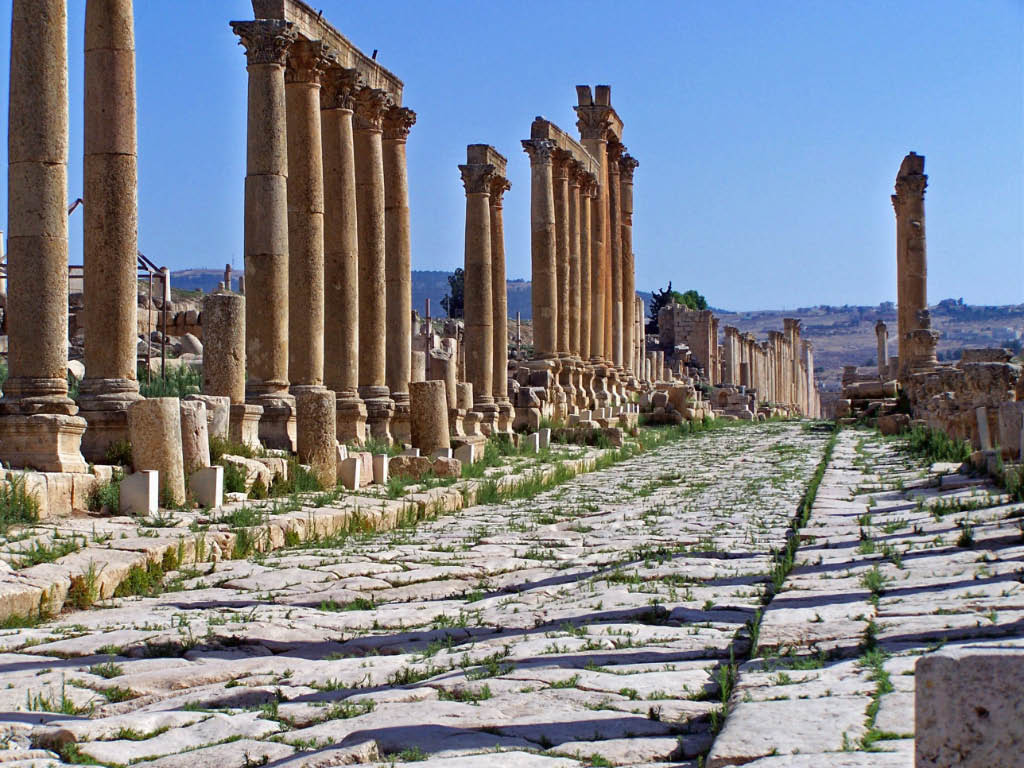
A ''cardo'' (: ''cardines'') was a north–south street in ancient Roman cities and military camps as an integral component of city planning. The ''cardo maximus'', or most often the ''cardo'', was the main or central north–south-oriented street. Etymology “Cardo” is the Latin word for "hinge". Being the hinge the turning point of the doors, the word ''cardo'' would also be used to designate other “turning points”, like the North Pole of the sky, or the four ''cardinal'' directions (quattuor ''cardines'' orbis terrarum). Also the “the principal line laid down in surveying land was called ''cardo''", which is also applied to the first street of a city: the street around which the city would be structured. Most Roman cities also had a ''decumanus maximus'', an east–west street that served as a secondary main street. Due to varying geography, in some cities the ''decumanus'' is the main street and the ''cardo'' is secondary, but in general the ''cardo maximus'' served ... [...More Info...] [...Related Items...] OR: [Wikipedia] [Google] [Baidu] |
Decumani
In Roman urban planning, a ''decumanus'' was an east–west-oriented road in a Roman city or ''castrum'' (military camp). The main ''decumanus'' of a particular city was the ''decumanus maximus'', or most often simply "the ''decumanus''". In the rectangular street grid of the typical Roman city plan, the ''decumanus'' was crossed by the perpendicular ''cardo'', a north–south street. In a military camp, the ''decumanus'' connected the Porta Praetoria (closest to the enemy) to the Porta Decumana (away from the enemy). In the center – called groma – of a city or ''castrum'', the ''decumanus maximus'' crossed the perpendicular ''cardo maximus'', the primary north–south road. The forum was normally located close to this intersection. Etymology ''Decumanus'' or ''decimanus'' was the Latin word for 'tenth'. This name is said to come from the fact that the ''via decumana'' or ''decimana'' (the "tenth") separated the Tenth Cohort from the Ninth in the legionary encampment, i ... [...More Info...] [...Related Items...] OR: [Wikipedia] [Google] [Baidu] |
Centuriation
Centuriation (in Latin ''centuriatio'' or, more usually, ''limitatio''), also known as Roman grid, was a method of land measurement used by the Romans. In many cases land divisions based on the survey formed a field system, often referred to in modern times by the same name. According to O. A. W. Dilke, centuriation combined and developed features of land surveying present in Egypt, Etruria, Greek towns and Greek countryside. Centuriation is characterised by the regular layout of a square grid traced using surveyors' instruments. It may appear in the form of roads, canals and agricultural plots. In some cases these plots, when formed, were allocated to Roman army veterans in a new colony, but they might also be returned to the indigenous inhabitants, as at Orange (France). The study of centuriation is very important for reconstructing landscape history in many former areas of the Roman empire. History The Romans began to use centuriation for the foundation, in the fourth cen ... [...More Info...] [...Related Items...] OR: [Wikipedia] [Google] [Baidu] |


