|
Avannaata
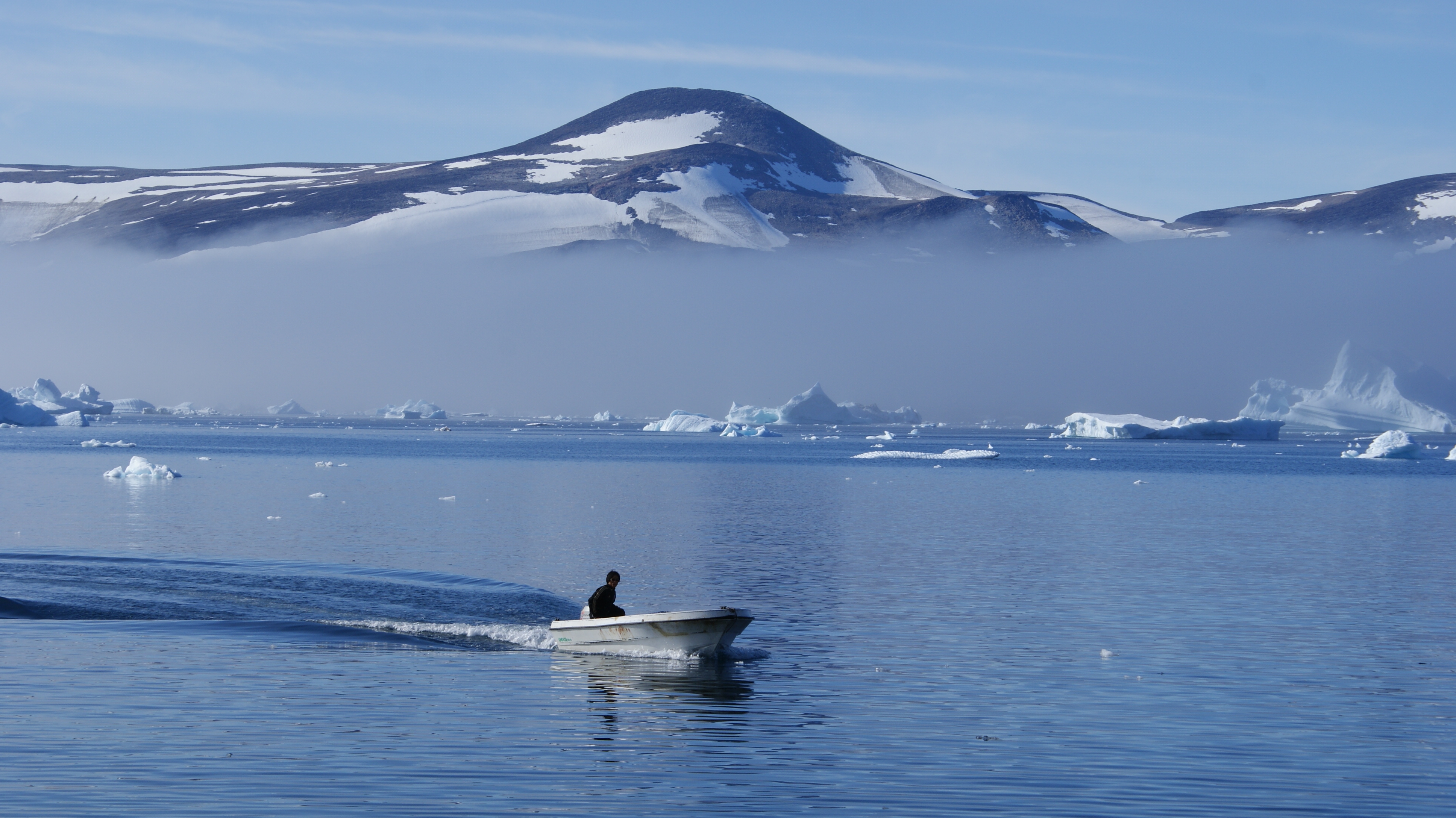
Avannaata (, ) is a municipality of Greenland created on 1 January 2018 from the bulk of the former Qaasuitsup municipality. It encompasses an area of 522,700 km2 and has 10,726 inhabitants. Geography In the south, Avannaata is flanked by the Qeqertalik municipality. In the southeast, it is bordered by the Sermersooq municipality; the border runs north–south ( 45° West meridian) through the center of the Greenland ice sheet (), so is free of traffic. In the east and northeast it is bordered by the Northeast Greenland National Park. Pituffik Space Base is an enclave on the Avannaata coast that is administered by the United States Space Force. At the southern end of the municipal coastline are the waters of Disko Bay, although some Disko Bay communities belong to the municipality of Qeqertalik. This bay is an inlet of the larger Baffin Bay, which to the north edges into the island of Greenland in the form of Melville Bay. The coastline of northeastern Baffin Bay is dott ... [...More Info...] [...Related Items...] OR: [Wikipedia] [Google] [Baidu] |
Administrative Divisions Of Greenland
Greenland is divided into five municipalities and two unincorporated areas. The municipalities are Avannaata, Kujalleq, Qeqertalik, Qeqqata, and Sermersooq.Statistics Greenland''Greenland in Figures, 2014''/ref> Northeast Greenland National Park is a huge unincorporated area that is outside the municipalities and larger than any of them. Pituffik Space Base is a small unincorporated enclave surrounded by the Avannaata municipality and administered by the United States Space Force. Municipalities History Greenland was divided into two inspectorates in 1782 – North Greenland, with its capital at Godhavn (now called Qeqertarsuaq), and South Greenland, with its capital at Godthaab (now Nuuk). These were directed by inspectors until 1924, then by governors. The two divisions were amalgamated in 1950 and the administration centralized at Godthaab. In 1953 a new constitution of Denmark promoted Greenland to full membership in the Danish state, with all of its inhabitant ... [...More Info...] [...Related Items...] OR: [Wikipedia] [Google] [Baidu] |
45th Meridian West
The meridian 45° west of Greenwich is a line of longitude that extends from the North Pole across the Arctic Ocean, Greenland, the Atlantic Ocean, South America, the Southern Ocean, and Antarctica to the South Pole. In Greenland the meridian defines the borders of Avannaata, Qeqertalik, and Qeqqata municipalities with the Sermersooq municipality and the Northeast Greenland National Park. The 45th meridian west forms a great ellipse with the 135th meridian east, and it is the reference meridian for the time zone UTC-3. From Pole to Pole Starting at the North Pole and heading south to the South Pole The South Pole, also known as the Geographic South Pole or Terrestrial South Pole, is the point in the Southern Hemisphere where the Earth's rotation, Earth's axis of rotation meets its surface. It is called the True South Pole to distinguish ..., the 45th meridian west passes through: : See also * 44th meridian west * 46th meridian west References {{Reflist w045 mer ... [...More Info...] [...Related Items...] OR: [Wikipedia] [Google] [Baidu] |
Canada
Canada is a country in North America. Its Provinces and territories of Canada, ten provinces and three territories extend from the Atlantic Ocean to the Pacific Ocean and northward into the Arctic Ocean, making it the world's List of countries and dependencies by area, second-largest country by total area, with the List of countries by length of coastline, world's longest coastline. Its Canada–United States border, border with the United States is the world's longest international land border. The country is characterized by a wide range of both Temperature in Canada, meteorologic and Geography of Canada, geological regions. With Population of Canada, a population of over 41million people, it has widely varying population densities, with the majority residing in List of the largest population centres in Canada, urban areas and large areas of the country being sparsely populated. Canada's capital is Ottawa and List of census metropolitan areas and agglomerations in Canada, ... [...More Info...] [...Related Items...] OR: [Wikipedia] [Google] [Baidu] |
Nares Strait
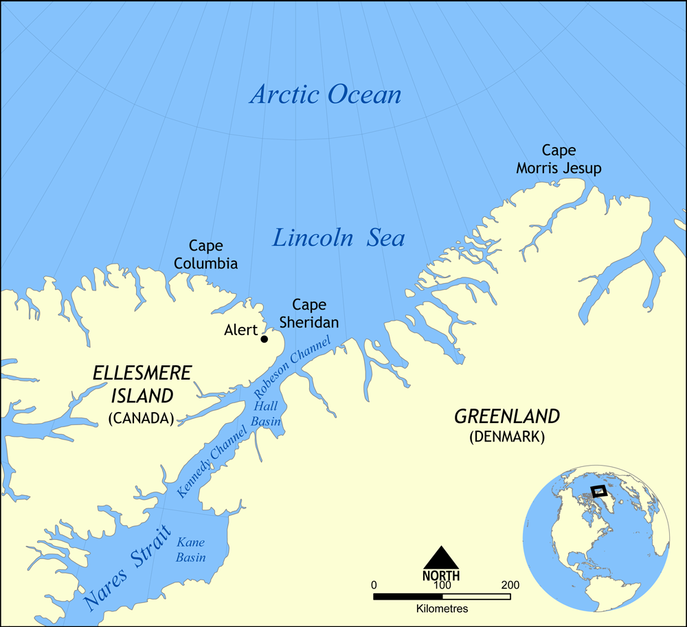
Nares Strait (; ) is a waterway between Ellesmere Island and Greenland that connects the northern part of Baffin Bay in the Atlantic Ocean with the Lincoln Sea in the Arctic Ocean. From south to north, the strait includes Smith Sound, Kane Basin, Kennedy Channel, Hall Basin and Robeson Channel. Nares Strait has a nearly permanent current from the north, powered by the Beaufort Gyre, making it harder to traverse for ships coming from the south. In 1964, its name was agreed by the Danish (''Stednavneudvalget'', now ''Stednavnenævnet'') and Canadian governments. The name derives from the British naval officer George Strong Nares. The strait and neighbouring waters are usually hazardous for navigation and shipping. Icebergs and pack ice are present year-round; in an extreme example during 1962–64, a by ice island drifted southward from the Lincoln Sea through the Nares and Davis Straits to the Labrador Sea.. During August, however, it is usually navigable by icebrea ... [...More Info...] [...Related Items...] OR: [Wikipedia] [Google] [Baidu] |
Siorapaluk
Siorapaluk ( West Greenlandic) or Hiurapaluk ( Polar Inuit) is a settlement in the Qaanaaq area of the Avannaata municipality in northern Greenland. The settlement is located in the northern shore of the Siorapaluup Kangerlua (Robertson Fjord). It has a population of 43 who speak the Inuktun language of the Polar Inuit as well as the Kalaallisut dialect of Greenlandic. Many of the inhabitants are direct descendants of the last migration of Inuit from Canada in the 20th century. Siorapaluk is the northernmost inhabited public settlement in Greenland, and one of the northernmost such settlements in the world, surpassed only by a few villages in Svalbard. It is also the world's northernmost place inhabited by natives. Geography Climate Hunting There is good hunting in the area of the settlement, and the cliffs around it function as breeding grounds for dovekie (UK English: little auk) ('' Alle alle'') and the thick-billed murre (UK English: Brünnich's guillemot) ('' Ur ... [...More Info...] [...Related Items...] OR: [Wikipedia] [Google] [Baidu] |
Upernavik Archipelago
Upernavik Archipelago is a vast coastal archipelago in the Avannaata municipality in northwestern Greenland, off the shores of northeastern Baffin Bay. The archipelago extends from the northwestern coast of Sigguup Nunaa peninsula in the south at approximately Nunavik, Saga Map, 1:250.000, Tage Schjøtt, 1992 to the southern end of Melville Bay () in the north at approximately .Upernavik Avannarleq, Saga Map, 1:250.000, Tage Schjøtt, 1992 History The archipelago belongs to the earliest-settled areas of Greenland, the first migrants arriving approximately 2,000 BCE. All southbound migrations of the Inuit passed through the area, leaving behind a trail of archeological sites. The early Saqqaq culture diminished in importance around 1,000 BCE, followed by the migrants of Dorset culture, who spread alongside the coast of Baffin Bay, being in turn displaced by the Thule people in the 13th and 14th centuries. The area has been continuously inhabited since then. Today the Upernavik A ... [...More Info...] [...Related Items...] OR: [Wikipedia] [Google] [Baidu] |
Melville Bay
Melville Bay (; ), is a large bay off the coast of northwestern Greenland. Located to the north of the Upernavik Archipelago, it opens to the south-west into Baffin Bay. Its Kalaallisut name, ''Qimusseriarsuaq'', means "the great dog sledding place". The bay was named after Robert Dundas, 2nd Viscount Melville, (1771 - 1851) First Lord of the Admiralty, head of the Admiralty. Geography Melville Bay is delimited by Cape York (Greenland), Cape York in the northeast and Wilcox Head, the western promontory on Kiatassuaq Island in the south.''Upernavik Avannarleq'', Saga Map, Tage Schjøtt, 1992 Some islands of the Upernavik Archipelago are in the Melville Bay area, such as Kiatassuaq Island, Kullorsuaq Island, Saarlia Island and Saqqarlersuaq Island. Melville Bay is free of fast ice between mid August and the end of September on average. Navigation is dangerous as there are numerous icebergs in the bay throughout the year.''Prostar Sailing Directions 2005 Greenland and Iceland Enrout ... [...More Info...] [...Related Items...] OR: [Wikipedia] [Google] [Baidu] |
Baffin Bay
Baffin Bay (Inuktitut: ''Saknirutiak Imanga''; ; ; ), located between Baffin Island and the west coast of Greenland, is defined by the International Hydrographic Organization as a marginal sea of the Arctic Ocean. It is sometimes considered a sea of the Atlantic Ocean, North Atlantic Ocean. It is connected to the Atlantic via Davis Strait and the Labrador Sea. The narrower Nares Strait connects Baffin Bay with the Arctic Ocean. The bay is not navigable most of the year because of the Arctic ice pack, ice cover and high density of Sea ice, floating ice and icebergs in the open areas. However, a polynya of about , known as the North Water Polynya, North Water, opens in summer on the north near Smith Sound. Most of the aquatic life of the bay is concentrated near that region. Extent The International Hydrographic Organization defines the limits of Baffin Bay as follows: History The area of the bay has been inhabited since BC. Around AD 1200, the initial Dorset culture ... [...More Info...] [...Related Items...] OR: [Wikipedia] [Google] [Baidu] |
Disko Bay
Disko Bay (; Christensen, N.O. & al.Elections in Greenland". ''Arctic Circular'', Vol. 4 (1951), pp. 83–85. Op. cit. "Northern News". ''Arctic'', Vol. 5, No. 1 (Mar 1952), pp. 58–59.) is a large bay on the western coast of Greenland. The bay constitutes a wide southeastern inlet of Baffin Bay. Geography To the south the coastline is complicated with multiple waterways of skerries and small islands in the Aasiaat archipelago. Qasigiannguit and Ilimanaq are the main settlements in the southeastern inlet, just south of the outflow of Ilulissat Icefjord. From the north the bay is bounded by Qeqertarsuaq (Disko Island), the largest island on the western coast. North of Ilulissat and west of Alluttoq Island the bay transforms into Sullorsuaq Strait separating Qeqertarsuaq from Nuussuaq Peninsula.Nuussuaq, Saga Map, Tage Schjøtt, 1992 It is the largest open bay in western Greenland, measuring north to south and east to west. It has an average depth of and ... [...More Info...] [...Related Items...] OR: [Wikipedia] [Google] [Baidu] |
United States Space Force
The United States Space Force (USSF) is the space force branch of the United States Department of Defense. It is one of the six United States Armed Forces, armed forces of the United States and one of the eight uniformed services of the United States. It is also one of two List of space forces, units, and formations#Independent space forces, independent space forces in the world. The United States Space Force traces its origins to the Air Force, Army, and Navy's military space programs created during the beginning of the Cold War. US military space forces first participated in combat operations during the Vietnam War and have participated in every U.S. military operation since, most notably in the Gulf War, which has been referred to as the "first space war." The Strategic Defense Initiative and creation of Air Force Space Command in the 1980s marked a renaissance for military space operations. Proposals for a U.S. Space Force were first seriously considered during the Reagan ... [...More Info...] [...Related Items...] OR: [Wikipedia] [Google] [Baidu] |
Enclave
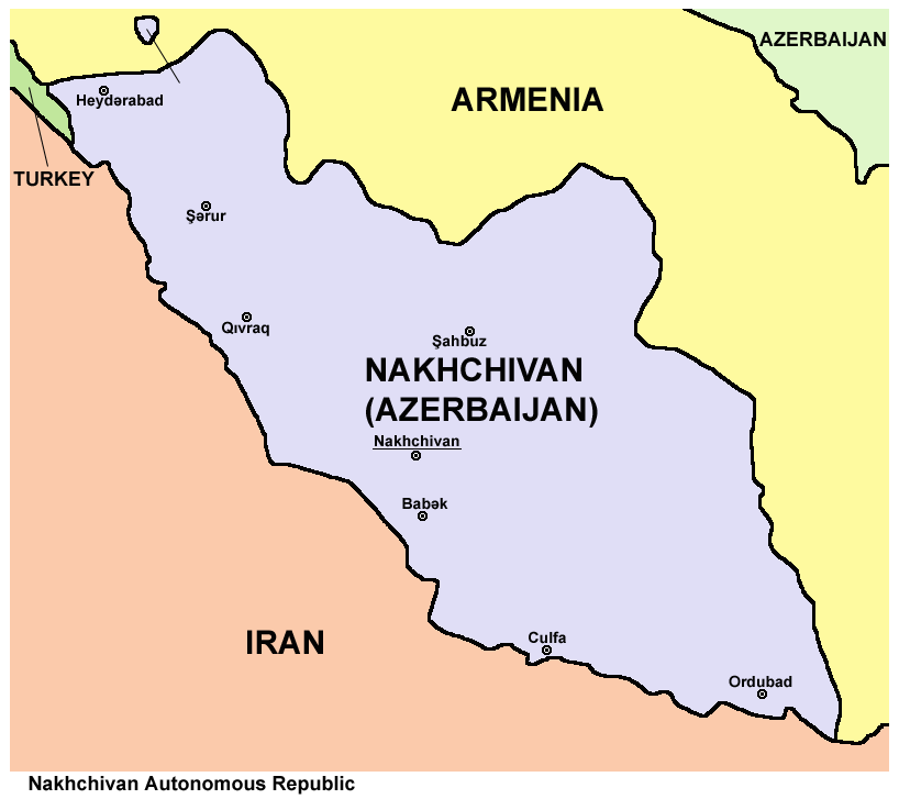
An enclave is a territory that is entirely surrounded by the territory of only one other state or entity. An enclave can be an independent territory or part of a larger one. Enclaves may also exist within territorial waters. ''Enclave'' is sometimes used improperly to denote a territory that is only partly surrounded by another state. Enclaves that are not part of a larger territory are not exclaves, for example Lesotho (enclaved by South Africa), and San Marino and Vatican City (both enclaved by Italy) are enclaved sovereign states. An exclave is a portion of a state or district geographically separated from the main part, by some surrounding alien territory. Many exclaves are also enclaves, but an exclave surrounded by the territory of more than one state is not an enclave. The Azerbaijani exclave of Nakhchivan is an example of an exclave that is not an enclave, as it borders Armenia, Iran, and Turkey. Semi-enclaves and semi-exclaves are areas that, except for possessing ... [...More Info...] [...Related Items...] OR: [Wikipedia] [Google] [Baidu] |
Pituffik Space Base
Pituffik Space Base ( ; ; ), formerly Thule Air Base (), is a United States Space Force base located on the northwest coast of Greenland in the Kingdom of Denmark under a defense agreement between Denmark and the United States. 150 United States guardians serve there, after the United States significantly reduced its presence from 6000 personnel during the Cold War. Denmark was a founding member of NATO in 1949, and the 1951 Greenland Defense Agreement allowed the United States to operate the base under a NATO framework, as long as both Denmark and the United States remain NATO members. Under the agreement, the Flag of Denmark, Danish national flag must be flown at the base to recognize that the base is on Danish territory, but the United States is allowed to fly its own flag alongside the Danish flag on the facilities it operates. It is the northernmost installation of the U.S. Armed Forces, north of the Arctic Circle and from the North Pole. Pituffik's Arctic environment in ... [...More Info...] [...Related Items...] OR: [Wikipedia] [Google] [Baidu] |


