|
Atlantic, Seattle
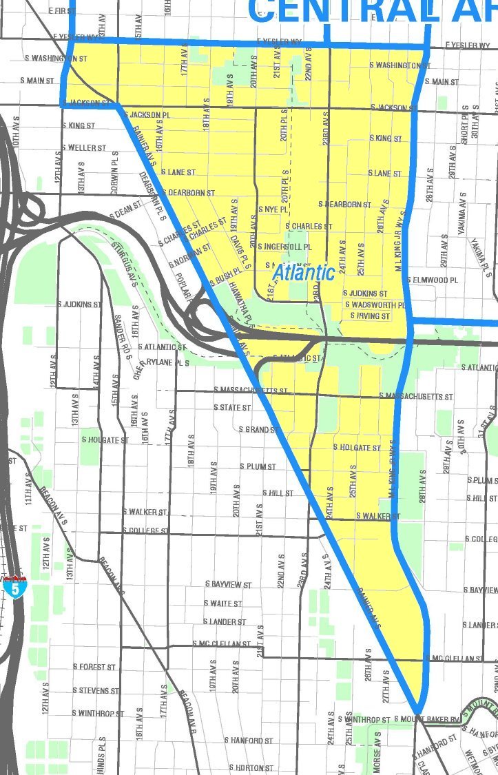
Atlantic is a neighborhood in the Central District of Seattle, Washington, United States. It is the northernmost neighborhood in the Rainier Valley area, located between Mount Baker Ridge and Beacon Hill, and may also be considered part of South Seattle. It is home to the Judkins Park neighborhood. Atlantic Atlantic is triangular, bounded on the north by E Yesler Way, beyond which are Mann and Minor neighborhoods; on the east by Martin Luther King, Jr. Way S, beyond which is Leschi on the Mount Baker Ridge; and on the west by Rainier Avenue S, beyond which is Yesler Terrace and the International District of Downtown Seattle as well as North Beacon Hill (with S Jackson Street and 12th Avenue S filling out a northwest corner). Judkins Park Judkins Park is rectangular within Atlantic, bounded on the south by Interstate 90, and on the west by 20th Avenue S. Judkins Park contains two baseball fields, a soccer field, a playground, and a small water park. (Like Atlantic, Ju ... [...More Info...] [...Related Items...] OR: [Wikipedia] [Google] [Baidu] |
Seattle - Atlantic Map
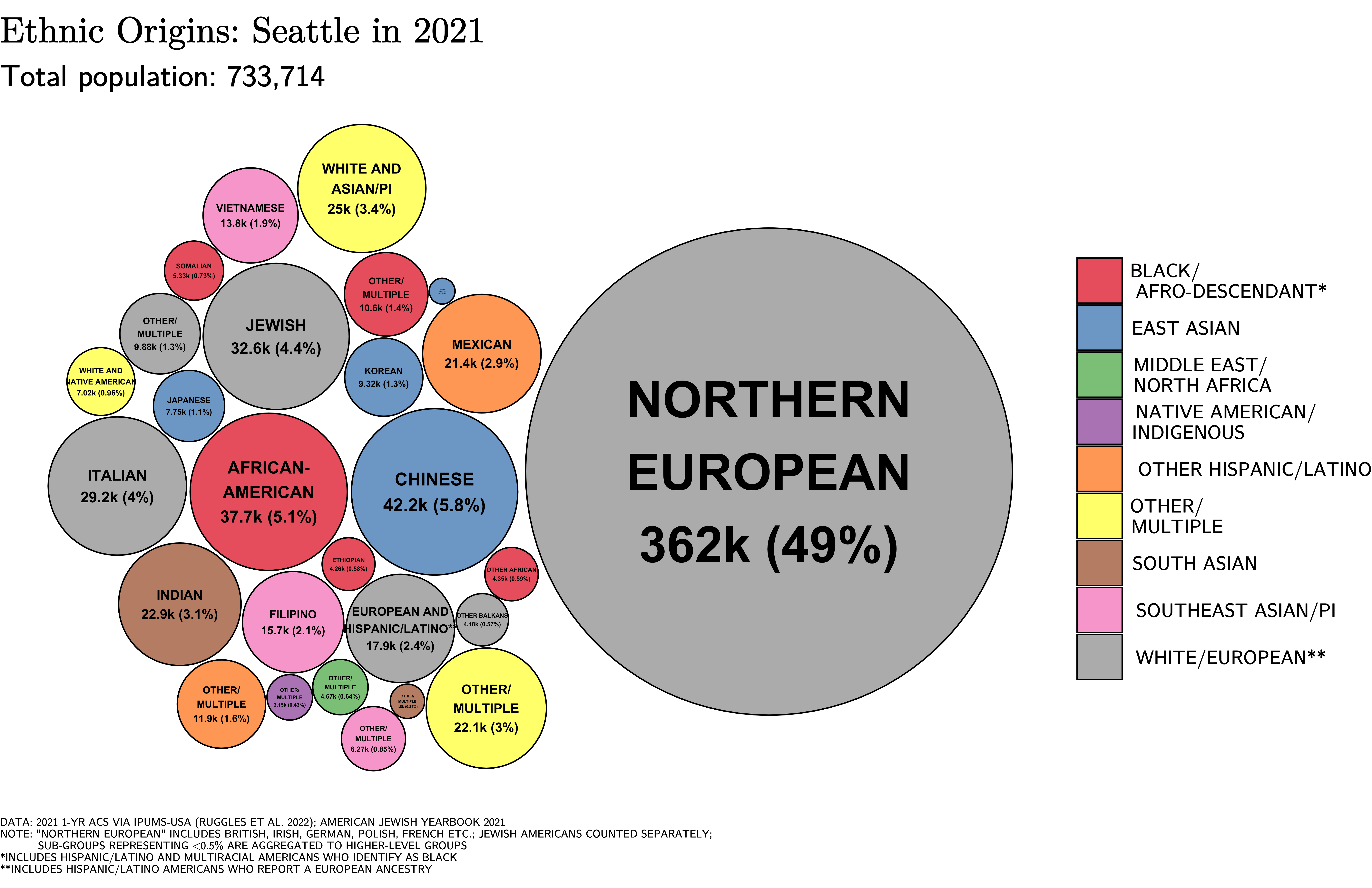
Seattle ( ) is the List of municipalities in Washington, most populous city in the U.S. state of Washington (state), Washington and in the Pacific Northwest region of North America. With a population of 780,995 in 2024, it is the List of United States cities by population, 18th-most populous city in the United States. The city is the county seat of King County, Washington, King County, the List of counties in Washington, most populous county in Washington. The Seattle metropolitan area's population is 4.02 million, making it the List of metropolitan statistical areas, 15th-most populous in the United States. Its growth rate of 21.1% between 2010 and 2020 made it one of the country's fastest-growing large cities. Seattle is situated on an isthmus between Puget Sound, an inlet of the Pacific Ocean, and Lake Washington. It is the northernmost major city in the United States, located about south of the Canada–United States border, Canadian border. A gateway for trade with East ... [...More Info...] [...Related Items...] OR: [Wikipedia] [Google] [Baidu] |
List Of Neighborhoods In Seattle
The city of Seattle, Washington, contains many districts and neighborhoods. The city's former mayor Greg Nickels has described it as "a city of neighborhoods". Early European settlers established widely scattered settlements on the surrounding hills, which grew into neighborhoods and autonomous towns. Conurbations tended to grow from such towns or from unincorporated areas around trolley stops during the 19th and early 20th centuries; the city has consequently suffered from transportation and street-naming problems. Definition of Seattle neighborhoods Seattle was established during an boom and bust, economic boom fueled by the timber industry; its early years were characterized by hasty expansion and development, under which residential areas were loosely defined by widely scattered plats. This arrangement was further solidified by the establishment of locally initiated community clubs, public libraries, public schools, and public parks, which created a sense of community an ... [...More Info...] [...Related Items...] OR: [Wikipedia] [Google] [Baidu] |
Central District, Seattle, Washington
The Central Area (commonly called the Central District or The CDMary T. HenrySeattle Neighborhoods: Central Area -- Thumbnail History HistoryLink, March 10, 2001. Accessed online 2009-10-19.) is a mostly residential neighborhood in Seattle located east of downtown and First Hill (12th Avenue and Rainier Avenue); west of Madrona, Leschi and Mt. Baker; south of Capitol Hill, and north of Rainier Valley. Historically, the Central District has been one of Seattle's most racially and ethnically diverse neighborhoods, and was once the center of Seattle's black community and a major hub of African-American businesses. History and demographics The culture and demographics of the Central District have changed repeatedly throughout many years. In 1882, William Grose purchased 12 acres of land in what was known as Madison Valley from Henry Yesler. Grose was already an established businessman in Seattle at the time, and his development of the area helped to establish the Central Distric ... [...More Info...] [...Related Items...] OR: [Wikipedia] [Google] [Baidu] |
Seattle, Washington
Seattle ( ) is the List of municipalities in Washington, most populous city in the U.S. state of Washington (state), Washington and in the Pacific Northwest region of North America. With a population of 780,995 in 2024, it is the List of United States cities by population, 18th-most populous city in the United States. The city is the county seat of King County, Washington, King County, the List of counties in Washington, most populous county in Washington. The Seattle metropolitan area's population is 4.02 million, making it the List of metropolitan statistical areas, 15th-most populous in the United States. Its growth rate of 21.1% between 2010 and 2020 made it one of the country's fastest-growing large cities. Seattle is situated on an isthmus between Puget Sound, an inlet of the Pacific Ocean, and Lake Washington. It is the northernmost major city in the United States, located about south of the Canada–United States border, Canadian border. A gateway for trade with East ... [...More Info...] [...Related Items...] OR: [Wikipedia] [Google] [Baidu] |
Rainier Valley, Seattle, Washington
Rainier Valley ( ) is a neighborhood in southeastern Seattle, Washington. It is located east of Beacon Hill; west of Mount Baker, Seward Park, and Leschi; south of the Central District and north of Rainier Beach. It is part of Seattle's South End. History White explorers and settlers first arrived in the area in the 1850s, and an explorer named Issac Ebey surveyed the area in 1850, with Ebey's assessment printed in an Oregon newspaper to entice other settlers. Native Americans had several encampments in the area prior to the settlers, and a permanent village at the south end of the valley. Italians were prominent in the north Valley in the early 20th century, the Central Valley was mostly settled by the same settlers and northern-European immigrants (primarily British and Scandinavian) who settled most of Seattle. Japanese farmers lived in the Valley since its inception and established two historic Japanese-American nurseries in the Valley - Mizukis and Holly Park, with Ho ... [...More Info...] [...Related Items...] OR: [Wikipedia] [Google] [Baidu] |
Leschi, Seattle, Washington
Leschi is a neighborhood in the city of Seattle, Washington, United States. Located on the western shore of Lake Washington, the residential neighborhood was named by its 19th-century developer for Chief Leschi of the Nisqually tribe, who was executed by territorial authorities in 1858 in Pierce County, Washington. Location The Leschi neighborhood is bordered by Lake Washington on the east, Interstate 90 on the south, beyond which is Mount Baker, Martin Luther King Jr. Way on the west, beyond which is the Central District and East Cherry Street on the north, beyond which is Madrona. Homes Residences in Leschi include condominiums (especially along the lake), refurbished bungalows and craftsman, contemporary styles, bricks, Tudors and mid-century ramblers. Curvy streets wind away up the hill from the lakefront, which means many residences get at least a partial lake view. The ''Seattle Post-Intelligencer'' described Leschi as "not an exclusive enclave for the rich, de ... [...More Info...] [...Related Items...] OR: [Wikipedia] [Google] [Baidu] |
Yesler Terrace, Seattle, Washington
Yesler Terrace is a mixed-income, mixed-use neighborhood in Seattle, Washington, United States. It was originally completed in 1941 as the state's first public housing development and the first racially integrated public housing development in the United States. It occupies much of the area formerly known as Yesler Hill, Yesler's Hill, or Profanity Hill. The development is administered by the Seattle Housing Authority, who have been redeveloping the neighborhood into a mixed-income area with multi-story buildings and community amenities since 2013. Etymology The name derives ultimately from Henry Yesler, pioneer mill owner. Yesler Way was originally the skid road on which logs were skidded down to the mill. The southern part of the hill came to be known as Yesler's Hill, Yesler Hill, or Profanity Hill. These names referred roughly to the part of First Hill south of the original King County Courthouse at 8th Avenue and Terrace Street. Razed in 1931, the courthouse site was roug ... [...More Info...] [...Related Items...] OR: [Wikipedia] [Google] [Baidu] |
International District, Seattle, Washington
International is an adjective (also used as a noun) meaning "between nations". International may also refer to: Music Albums * ''International'' (Kevin Michael album), 2011 * ''International'' (New Order album), 2002 * ''International'' (The Three Degrees album), 1975 *''International'', 2018 album by L'Algérino Songs * The Internationale, the left-wing anthem * "International" (Chase & Status song), 2014 * "International", by Adventures in Stereo from ''Monomania'', 2000 * "International", by Brass Construction from ''Renegades'', 1984 * "International", by Thomas Leer from ''The Scale of Ten'', 1985 * "International", by Kevin Michael from ''International'' (Kevin Michael album), 2011 * "International", by McGuinness Flint from ''McGuinness Flint'', 1970 * "International", by Orchestral Manoeuvres in the Dark from ''Dazzle Ships (album), Dazzle Ships'', 1983 * "International (Serious)", by Estelle from ''All of Me (Estelle album), All of Me'', 2012 Politics * Internationa ... [...More Info...] [...Related Items...] OR: [Wikipedia] [Google] [Baidu] |
Downtown Seattle
Downtown is the central business district of Seattle, Washington. It is fairly compact compared with other city centers on the U.S. West Coast due to its geographical situation, being hemmed in on the north and east by hills, on the west by Elliott Bay, and on the south by reclaimed land that was once tidal flats. It is bounded on the north by Denny Way, beyond which are Lower Queen Anne (sometimes known as "Uptown"), Seattle Center, and South Lake Union; on the east by Interstate 5, beyond which is Capitol Hill to the northeast and Central District to the east; on the south by S Dearborn Street, beyond which is Sodo; and on the west by Elliott Bay, a part of Puget Sound. Neighborhoods Belltown, Denny Triangle, the retail district, the West Edge, the financial district, the government district, Pioneer Square, Chinatown, Japantown, Little Saigon, and the western flank of First Hill west of Broadway make up downtown Seattle's chief neighborhoods. Near the center ... [...More Info...] [...Related Items...] OR: [Wikipedia] [Google] [Baidu] |
Beacon Hill, Seattle, Washington
Beacon Hill is a hill and neighborhood in southeastern Seattle, Washington. It is roughly bounded on the west by Interstate 5, on the north by Interstate 90, on the east by Rainier Avenue South, Cheasty Boulevard South, and Martin Luther King Junior Way South, and on the south by the Seattle city boundary. It is part of Seattle's South End. The neighborhood has a major population of Asian Americans and African Americans and is among the most racially diverse in Seattle. It was formerly home to the world headquarters of Amazon (at the Pacific Tower) and present home to the Seattle Division of the Department of Veterans Affairs' Puget Sound Health Care System. Geography Beacon Hill offers views of downtown, the Industrial District, Elliott Bay, First Hill, Rainier Valley, and, when the weather is good, Mount Rainier and the Olympic Mountains. It is roughly bounded on the west by Interstate 5, on the north by Interstate 90, on the east by Rainier Avenue South, Cheasty Boulevar ... [...More Info...] [...Related Items...] OR: [Wikipedia] [Google] [Baidu] |
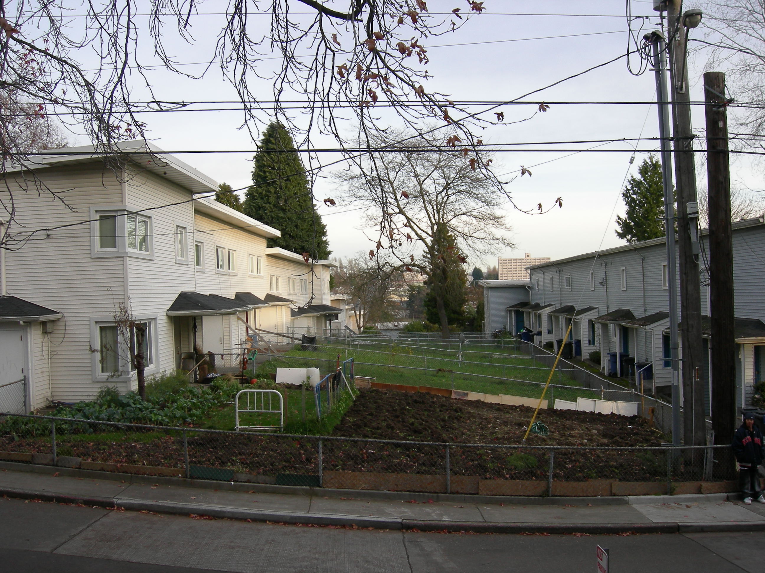
Seattle - Atlantic Street Center 03
Seattle ( ) is the most populous city in the U.S. state of Washington and in the Pacific Northwest region of North America. With a population of 780,995 in 2024, it is the 18th-most populous city in the United States. The city is the county seat of King County, the most populous county in Washington. The Seattle metropolitan area's population is 4.02 million, making it the 15th-most populous in the United States. Its growth rate of 21.1% between 2010 and 2020 made it one of the country's fastest-growing large cities. Seattle is situated on an isthmus between Puget Sound, an inlet of the Pacific Ocean, and Lake Washington. It is the northernmost major city in the United States, located about south of the Canadian border. A gateway for trade with East Asia, the Port of Seattle is the fourth-largest port in North America in terms of container handling . The Seattle area has been inhabited by Native Americans (such as the Duwamish, who had at least 17 villages around Elliot ... [...More Info...] [...Related Items...] OR: [Wikipedia] [Google] [Baidu] |


