|
Arkwright Town Railway Station
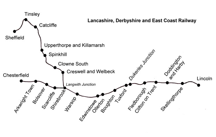
Arkwright Town railway station was in Arkwright Town, Derbyshire, England. History The line and station were opened by the LD&ECR in March 1897. The company struggled financially and was absorbed by the GCR in 1907 which in turn became part of the LNER at the Grouping of 1923. The station then passed to British Railways on nationalisation in 1948, only to be closed to passenger traffic in 1951 and closed completely on 2 February 1963. The station was originally to have been called Duckmanton, and tickets bearing that name were issued but the Staveley Company objected. Perhaps the name Arkwright Town was used from the start, but the stock of tickets bearing "Duckmanton" was used rather than wasted. The lines through the station ran from West to East. West of the station lay, from the west, Duckmanton Tunnel and Cutting, the GCR main line (which ran North to South from Sheffield Victoria to London Marylebone Marylebone station ( ) is a Central London railway termi ... [...More Info...] [...Related Items...] OR: [Wikipedia] [Google] [Baidu] |
Chesterfield, Derbyshire
Chesterfield is a market town and unparished area in the Borough of Chesterfield, Derbyshire, England, north of Derby and south of Sheffield at the confluence of the River Rother and River Hipper. In 2011 the built-up-area subdivision had a population of 88,483, making it the second-largest settlement in Derbyshire, after Derby. The wider borough had a population of 103,801 in 2011. In 2011, the town had a population of 76,753. It has been traced to a transitory Roman fort of the 1st century CE. The name of the later Anglo-Saxon village comes from the Old English ''ceaster'' (Roman fort) and ''feld'' (pasture). It has a sizeable street market three days a week. The town sits on an old coalfield, but little visual evidence of mining remains. The main landmark is the crooked spire of the Church of St Mary and All Saints. History Chesterfield was in the Hundred of Scarsdale. The town received its market charter in 1204 from King John, which constituted the town as a f ... [...More Info...] [...Related Items...] OR: [Wikipedia] [Google] [Baidu] |
Staveley Coal And Iron Company
The Staveley Coal and Iron Company Limited was an industrial company based in Staveley, near Chesterfield, North Derbyshire. History The company was registered in 1863, appearing in provincial stock exchange reports from 1864. It exploited local ironstone quarried from land owned by the Duke of Devonshire on the outskirts of the village. It developed into coal mining, owning several collieries and also into chemical production, first from those available from coal tar distillation, later to cover a wide and diverse range. Part of the plant at Staveley was a sulphuric acid manufacturing unit making use of the Contact Process. It was during the years of World War 1 that the company developed its chemical operations beyond coal-tar chemicals and began production of sulphuric and nitric acids. During the war they also made picric acid, TNT and guncotton. Following the end of hostilities the company laid plans to develop a range of chlorinated organics and to this end purchase ... [...More Info...] [...Related Items...] OR: [Wikipedia] [Google] [Baidu] |
Former Lancashire, Derbyshire And East Coast Railway Stations
A former is an object, such as a template, gauge or cutting die, which is used to form something such as a boat's hull. Typically, a former gives shape to a structure that may have complex curvature. A former may become an integral part of the finished structure, as in an aircraft fuselage, or it may be removable, being using in the construction process and then discarded or re-used. Aircraft formers Formers are used in the construction of aircraft fuselage, of which a typical fuselage has a series from the nose to the empennage, typically perpendicular to the longitudinal axis of the aircraft. The primary purpose of formers is to establish the shape of the fuselage and reduce the column length of stringers to prevent instability. Formers are typically attached to longerons, which support the skin of the aircraft. The "former-and-longeron" technique (also called stations and stringers) was adopted from boat construction, and was typical of light aircraft built until the ad ... [...More Info...] [...Related Items...] OR: [Wikipedia] [Google] [Baidu] |
Headington
Headington is an eastern suburb of Oxford, England. It is at the top of Headington Hill overlooking the city in the Thames valley below, and bordering Marston, Oxford, Marston to the north-west, Cowley, Oxfordshire, Cowley to the south, and Barton, Oxfordshire, Barton and Risinghurst to the east. The life of the large residential area is centred upon London Road, the main road between London and Oxford. History The site of Headington shows evidence of continued occupation from the Stone Age, as the 2001 field Excavation (archaeology), excavations in Barton, Oxfordshire, Barton Lane found, suggesting a date in the 11th century BC. Pottery was found on the Manor Ground, Oxford, Manor Ground, suggesting an British Iron Age, Iron Age settlement there in the 7th century BC. Roman Britain, Roman kilns from about 300 have been found, including one now on display at the Museum of Oxford. History of Anglo-Saxon England, Anglo-Saxon burial remains from about 500 have also been discovered. ... [...More Info...] [...Related Items...] OR: [Wikipedia] [Google] [Baidu] |
Clophill
Clophill is a village and civil parish clustered on the north bank of the River Flit, Bedfordshire, England. It is recorded in the Domesday Book of 1086 as ''Clopelle''. "Clop" likely means 'tree-stump' in Old English. However, it also has cognate terms for clay, with which the soil of mid Bedfordshire is rich. Extent and demography In the 1851 census, the men of the parish numbered 560; of these, 238 were agricultural labourers; women numbered. In the 2011 Census the population was 1,750. The contiguous housing of Clophill Road and its side streets falls into the civil and ecclesiastical parishes of Maulden. Church St Mary's old church The old St Mary's Church was built around 1350, and replaced by a new church in the 1840s (250 m SSW). It gradually fell into ruin, and as an inactive church, had restoration carried out for secular purposes in the early 2010s. Active churches The new St Mary's church is in the High Street, built 1848–1849. The current recto ... [...More Info...] [...Related Items...] OR: [Wikipedia] [Google] [Baidu] |
Doe Lea Viaduct
Doe Lea Viaduct is a former railway viaduct near Carr Vale, Bolsover, Derbyshire, England. Location The viaduct was originally, formally known as Bolsover Viaduct and is often referred to as Carr Vale Viaduct. It was a substantial, double track structure carrying the LD&ECR's Chesterfield Market Place to Lincoln Central main line over the Midland Railway's Pleasley to Staveley Doe Lea Branch a short distance south of the latter's Bolsover Castle station. The River Doe Lea passed through a culvert under the viaduct's western approach embankment. The structure was also situated near Bolsover's "Model Village" at the bottom of Bolsover Hill. History The viaduct, which consisted of eight brick arches, was opened to goods traffic in February 1897, with passenger traffic following from 8 March. The section between Chesterfield and Langwith Junction (by then renamed Shirebrook North), was closed to passenger traffic by British Railways in December 1951, due to the unsafe c ... [...More Info...] [...Related Items...] OR: [Wikipedia] [Google] [Baidu] |
Bolsover South Railway Station
Bolsover South is a former railway station in Carr Vale, Bolsover, Derbyshire, England. History The station was opened by the LD&ECR in March 1897 as plain "Bolsover". It was closed to all traffic by British Railways in December 1951, primarily due to the prohibitive cost of repairing and maintaining Bolsover Tunnel. Track lifting started immediately after closure and was completed within weeks, though the station building survived as an increasingly vandalised eyesore for some years. The photograph opposite shows the characteristic Station Master's house in 1963, the station itself was behind the bush on the extreme right of the photo. Also behind the photo to the left was a railway-served jam factory. The station was built in Carr Vale and was one of only two places on the LD&ECR where a level crossing was necessary, the other being Skellingthorpe. To the west was Doe Lea Viaduct and to the east was a limestone ridge through which it was necessary to drive the notoriou ... [...More Info...] [...Related Items...] OR: [Wikipedia] [Google] [Baidu] |
Arkwright Town Junction
Arkwright Town Junction is a former railway junction near Arkwright Town in Derbyshire, England. Context Arkwright Town Junction was one of four interrelated junctions built by the GCR GCR (or GCRS) may refer to: Science * Galactic cosmic ray, a cosmic ray from outside the Solar System * Geocentric Celestial Reference System, a coordinate system for near-Earth objects like satellites * Geological Conservation Review, a proc ... to connect its main line to the LD&ECR's main line when it took the latter company over in 1907. The junctions are usually referred to collectively as "Duckmanton Junction" or occasionally as "Duckmanton Junctions." Description The four junctions operated interactively, so they are described together in the article Duckmanton Junction to which the reader is referred. References External links Arkwright Town Junction: old OS map via ''npemap'' {{coord, 53, 13, 55.42, N, 1, 21, 7.84, W, type:landmark_region:GB-DBY, display=title Rail junction ... [...More Info...] [...Related Items...] OR: [Wikipedia] [Google] [Baidu] |
London Marylebone Railway Station
Marylebone station ( ) is a Central London railway terminus and connected London Underground station in the Marylebone area of the City of Westminster. On the National Rail network it is also known as London Marylebone and is the southern terminus of the Chiltern Main Line to Birmingham. An accompanying Underground station is on the Bakerloo line between Edgware Road and in Transport for London's fare zone 1. The station opened on 15 March 1899 as the London terminus of the Great Central Main Line (GCML), the last major railway to open in Britain for 100 years, linking the capital to the cities of Leicester, Sheffield and Manchester. Marylebone was the last of London's main line termini to be built and is one of the smallest, opening with half of the platforms originally planned. There has been an interchange with the Bakerloo line since 1907, but not with any other lines. Traffic declined at Marylebone station from the mid-20th century, particularly after the GCML close ... [...More Info...] [...Related Items...] OR: [Wikipedia] [Google] [Baidu] |
Sheffield Victoria Railway Station
Sheffield Victoria was the main railway station in Sheffield, Yorkshire, England, on the Great Central Railway, between Chesterfield and Penistone. History Early history Engineered by Joseph Locke, the Sheffield, Ashton-under-Lyne and Manchester Railway linking Manchester and Sheffield opened in 1845. Originally, this line terminated at the Bridgehouses station, which was about to the west of the future Victoria station. In 1847, the Sheffield, Ashton-under-Lyne and Manchester Railway merged with two other railway companies to form the Manchester, Sheffield and Lincolnshire Railway. The station at Bridgehouses had been outgrown, so an extension and new station were planned. John Fowler, who later gained fame for co-designing the Forth Railway Bridge in Scotland, was employed to engineer the extension and station. Fowler's design included a viaduct over the Wicker that was high, long and two island platforms long. The extension was completed in 1847–1848 and the new ... [...More Info...] [...Related Items...] OR: [Wikipedia] [Google] [Baidu] |
Great Central Main Line
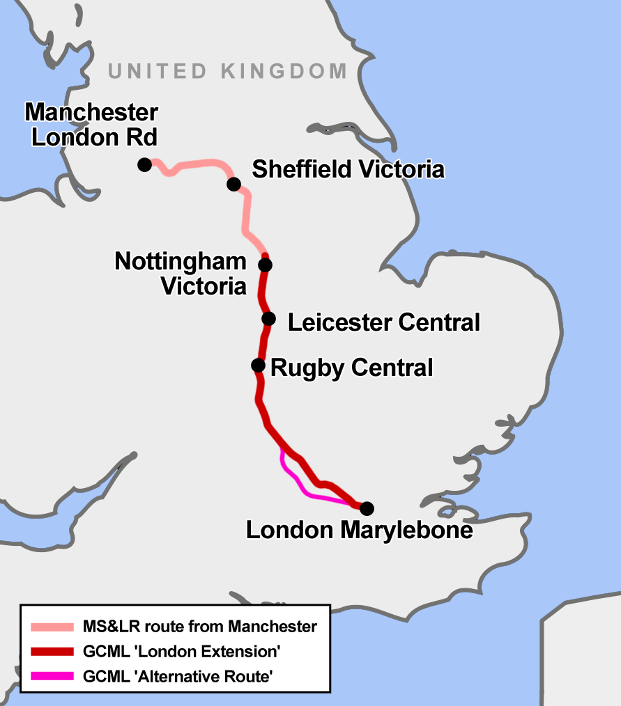
The Great Central Main Line (GCML), also known as the London Extension of the Manchester, Sheffield and Lincolnshire Railway (MS&LR), is a former railway line in the United Kingdom. The line was opened in 1899 and built by the Great Central Railway running from Sheffield Victoria railway station, Sheffield in the North of England, southwards through Nottingham Victoria railway station, Nottingham and Leicester Central railway station, Leicester to Marylebone station, Marylebone in London. The GCML was the last main line railway to be built in Britain during the Victorian era, Victorian period. Built by the railway entrepreneur Edward Watkin with the aim to run as a fast trunk route from the North and the East Midlands to London and the south of England. Initially not a financial success, it recovered under the leadership of Sam Fay. Although initially planned for long-distance passenger services, in practice the line's most important function became to carry goods traffic, notably ... [...More Info...] [...Related Items...] OR: [Wikipedia] [Google] [Baidu] |


