|
Arakan
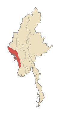
Arakan ( or ; , ), formerly anglicised as Aracan, is the historical geographical name for the northeastern coastal region of the Bay of Bengal, covering present-day Bangladesh and Myanmar. The region was called "Arakan" for centuries. It is generally associated with the Rakhine State in Myanmar. The people of the region were known as the Arakanese. When Burma gained independence from Britain in 1948, the Burmese part of the region was called Arakan State. The Burmese military junta changed its name to Rakhine State in 1989 – along with the country's name being changed from Burma to Myanmar, and its capital name from Rangoon to Yangon. Arakan's first states can be traced to the 4th century. Arakan was one of the first Indianised kingdoms in Southeast Asia. It was home to the sacred Mahamuni sculpture of Buddha, which was later transferred to Mandalay by Burmese conquerors in the 18th century. For 356 years between 1428 and 1784, Arakan was ruled by the Kingdom of Mrauk ... [...More Info...] [...Related Items...] OR: [Wikipedia] [Google] [Baidu] |
Mrauk U Kingdom
The Kingdom of Mrauk-U (Arakanese language, Arakanese: မြောက်ဦး ဘုရင့်နိုင်ငံတော်) was a kingdom that existed on the Arakan coastal plain from 1429 to 1785. Based in the capital Mrauk-U, near the eastern coast of the Bay of Bengal, the kingdom ruled over what is now Rakhine State, Myanmar, and the southern part of Chittagong Division, Bangladesh. Though it started out as a protectorate of the Bengal Sultanate from 1429 to 1531, Mrauk-U went on to conquer Chittagong with the help of the Portugal, Portuguese. It twice fended off the First Toungoo Empire, Toungoo Burma's attempts to conquer the kingdom in 1546–1547, and 1580–1581. At its height of power, it briefly controlled the Bay of Bengal coastline from the Sundarbans to the Gulf of Martaban from 1599 to 1603.Myint-U 2006: 77Topich, Leitich 2013: 21 In 1666, it lost control of Chittagong after a war with the Mughal Empire. Its existence continued until 1785, when it was con ... [...More Info...] [...Related Items...] OR: [Wikipedia] [Google] [Baidu] |
Rakhine Language
Rakhine (; , MLCTS: ), also known as Arakanese, is a Tibeto-Burman language spoken in western Myanmar, primarily in the Rakhine State, and parts of south-eastern Bangladesh. Closely related to Burmese, the language is spoken by the Rakhine and Marma peoples; it is estimated to have around one million native speakers and it is spoken as a second language by a further million. Though Arakanese has some similarity with standard Burmese, Burmese speakers find it difficult to communicate with Arakanese speakers. Thus, it is often considered to be a dialect or variety of Burmese. As there are no universally accepted criteria for distinguishing a language from a dialect, scholars and other interested parties often disagree about the linguistic, historical and social status of Arakanese. There are three dialects of Arakanese: Sittwe– Marma (about two thirds of speakers), Ramree, and Thandwe. Vocabulary While Arakanese and Standard Burmese share the majority of lexicon, Arakan ... [...More Info...] [...Related Items...] OR: [Wikipedia] [Google] [Baidu] |
Rakhine State
Rakhine State ( ; , ; ), formerly known as Arakan State, is a Administrative divisions of Myanmar, state in Myanmar (Burma). Situated on the western coast, it is bordered by Chin State to the north, Magway Region, Bago Region and Ayeyarwady Region to the east, the Bay of Bengal to the west and the Chittagong Division, Chattogram Division of Bangladesh to the northwest. It is located approximately between latitudes 17°30' north and 21°30' north and longitudes 92°10' east and 94°50' east. The north–south Arakan Mountains or Rakhine Yoma separate Rakhine State from central Myanmar. Off the coast of Rakhine State there are some fairly large islands such as Ramree Island, Ramree, Cheduba and Myingun Island, Myingun. Rakhine State has an area of and its capital is Sittwe (formerly known as Akyab). Names The state was historically known as Arakan in English until the Burmese government adopted the English name Rakhine in 1989. History The history of the region of Arakan ... [...More Info...] [...Related Items...] OR: [Wikipedia] [Google] [Baidu] |
Bengal Sultanate
The Bengal Sultanate (Middle Bengali: , Classical Persian: ) was a Post-classical history, late medieval sultanate based in the Bengal region in the eastern South Asia between the 14th and 16th century. It was the dominant power of the Ganges-Brahmaputra Delta, with a network of mint towns spread across the region. The Bengal Sultanate had a circle of vassal states in the Indian subcontinent, including parts of Odisha in the southwest, parts of Bihar in the northwest, parts of Assam in the northeast, Arakan in the southeast, and Tripura in the east. The Bengal Sultanate controlled large parts of the eastern South Asia during its five dynastic periods, reaching its peak under Jalaluddin Muhammad Shah. Its raids and conquests reached Kingdom of Nepal, Nepal in the north, Brahmaputra valley (modern-day Assam) in the east, and Jaunpur Sultanate, Jaunpur and Varanasi in the west. It was reputed as a thriving trading nation. Its decline began with an interregnum by the Sur Empire, fo ... [...More Info...] [...Related Items...] OR: [Wikipedia] [Google] [Baidu] |
Dhanyawadi
Dhanyawaddy (; ) was the capital of the first Rakhine people, Arakanese Kingdom, located in what is now Northern Rakhine State, Myanmar. The name is a corruption of the Pali word ''Dhannavati'', which means "large area or rice cultivation or the rice bowl". Like many of its successors, the Kingdom of Dhanyawadi was based on trade between the East (pre-Kingdom of Pagan, Pagan Myanmar, Pyu city states, Pyu, China, the Thaton Kingdom, Mons), and the West (Indian subcontinent). The ancient city of Dhanyawaddy is located 6 miles east of Kyauktaw, Rakhine State, on the right side of the Thay Chaung River at the intersection of latitude 20°52'07.2" north and longitude 93°03'49.9" east. Arakanese legends claim that a Shakya, Sakya clan of Buddha are founder of Dhanyawadi Kingdom. Now they are mixed with Rakhine people.Ethnic Culture Traditional Customs Rakhine 1976 (Burmese: တိုင်းရင်းသားယဉ်ကျေးမှု ရိုးရာဓလေ့ထုံ� ... [...More Info...] [...Related Items...] OR: [Wikipedia] [Google] [Baidu] |
Mrauk-U
Mrauk U ( ) is a town in northern Rakhine State, Myanmar. It is the capital of Mrauk-U Township, a subregion of the Mrauk-U District. Mrauk U is culturally significant for the local Rakhine (Arakanese) people and is the location of many important archeological sites. From 1430 until 1785, it was the capital of the Mrauk U Kingdom, the largest and most powerful Rakhine kingdom in history. Geography Mrauk U lies roughly east of the Kaladan River on the banks of its minor tributaries. The town is located on a small outcrop of the Rakhine Yoma on the eastern side of the Kaladan's alluvial plain. Thus, the surrounding countryside is hilly yet also contains a great deal of marshes, mangroves and lakes. Climate Mrauk U, like all of Rakhine State, has an extreme tropical monsoon climate (Köppen ''Am''). The town receives over of rain a year from the southwest monsoon, making it one of the wettest parts of monsoon Asia. Despite this, Mrauk U is actually less wet than most o ... [...More Info...] [...Related Items...] OR: [Wikipedia] [Google] [Baidu] |
Sittwe
Sittwe (, ), formerly Akyab (), is the capital of Rakhine State, Myanmar (Burma). Sittwe is located on an estuarial island created at the confluence of the Kaladan, Mayu, and Lay Mro rivers emptying into the Bay of Bengal. As of 2019 the city has an estimated population of over 120,000 inhabitants. It is the administrative seat of Sittwe Township and Sittwe District. Names The name Sittwe () is derived from the Burmese pronunciation of Arakanese , meaning "the place where the war meets". When the Burmese king Bodawpaya invaded the Mrauk U Kingdom in 1784, the Rakhine defenders encountered the Burmese force at the mouth of Kaladan river. In the ensuing battle, which was waged on both land and water, the Mrauk U forces were defeated. The place where the battle occurred came to be called ''Saittwe'' by the Rakhine and then as ''Sittwe'' by the Burmese. The name was initially anglicized as ''Tset-twe'' and ''Site-tway''. The colonial name Akyab () derived from the town ... [...More Info...] [...Related Items...] OR: [Wikipedia] [Google] [Baidu] |
Third Burmese Empire
The Konbaung dynasty (), also known as the Third Burmese Empire (တတိယမြန်မာနိုင်ငံတော်), was the last dynasty that ruled Burma from 1752 to 1885. It created the second-largest empire in Burmese history and continued the administrative reforms begun by the Toungoo dynasty, laying the foundations of the modern state of Burma. The reforms, however, proved insufficient to stem the advance of the British Empire, who defeated the Burmese in all three Anglo-Burmese Wars over a six-decade span (1824–1885) and ended the millennium-old Burmese monarchy in 1885. Pretenders to the dynasty claim descent from Myat Phaya Lat, one of Thibaw's daughters. An expansionist dynasty, the Konbaung kings waged campaigns against the Lushai Hills, Manipur, Assam, Arakan, the Mon kingdom of Pegu, Siam, and the Qing dynasty of China—thus establishing the Third Burmese Empire. Subject to later wars and treaties with the British, the modern state of Myan ... [...More Info...] [...Related Items...] OR: [Wikipedia] [Google] [Baidu] |
Waithali
Waithali (, , ) located in today's northern Rakhine State, Myanmar, was the capital of the Waithali Kingdom from 370 to 818. The former capital site is approximately north-east of Sittwe, and east of Ram Chaung, a tributary of the Kaladan river. Like much of northern Rakhine State, Waithali is in a hilly locale. Like its predecessor, Dhanyawadi, the former capital site has fallen into ruin and much of it is now deserted. Only a few temples and traces of the old city wall remain. The site is about an hour's bus ride from Mrauk U. Etymology Waithali is the Burmese language pronunciation of the Pali word Vesali (). History It has been estimated that the centre of power of the Arakanese world shifted from Dhanyawadi to Waithali in the 4th century AD as Dhanyawadi Kingdom ended in 370 AD. Although it was established later than Dhanyawadi, Waithali is the most Indianized of the four Arakanese kingdoms to emerge. Like all of the Arakanese Kingdoms to emerge, the Kingdom of Waithali w ... [...More Info...] [...Related Items...] OR: [Wikipedia] [Google] [Baidu] |
Myanmar
Myanmar, officially the Republic of the Union of Myanmar; and also referred to as Burma (the official English name until 1989), is a country in northwest Southeast Asia. It is the largest country by area in Mainland Southeast Asia and has a population of about 55 million. It is bordered by India and Bangladesh to its northwest, China to its northeast, Laos and Thailand to its east and southeast, and the Andaman Sea and the Bay of Bengal to its south and southwest. The country's capital city is Naypyidaw, and its largest city is Yangon (formerly Rangoon). Early civilisations in the area included the Tibeto-Burman-speaking Pyu city-states in Upper Myanmar and the Mon kingdoms in Lower Myanmar. In the 9th century, the Bamar people entered the upper Irrawaddy River, Irrawaddy valley, and following the establishment of the Pagan Kingdom in the 1050s, the Burmese language and Culture of Myanmar, culture and Buddhism in Myanmar, Theravada Buddhism slowly became dominant in the co ... [...More Info...] [...Related Items...] OR: [Wikipedia] [Google] [Baidu] |


