|
Alexo Formation
The Alexo Formation a stratigraphic unit of Late Devonian (late Frasnian to early Famennian) age. It is present on the western edge of the Western Canada Sedimentary Basin in the central Rocky Mountains and foothills of Alberta. The formation consists primarily of dolomite. It is locally fossiliferous and includes remains of marine animals such as brachiopods and conodonts. Lithology and thickness The Alexo Formation was deposited in a marine setting and consists of dolomite, silty and argillaceous dolomite, dolomitic siltstone, and vuggy dolomite. It has a maximum thickness of about , and is thinner in areas where it covers carbonate buildups (reefs) in the underlying formations. Distribution and relationship to other units The Alexo Formation is present in the central Rocky Mountains of Alberta and the adjacent foothills, extending from the Crows Nest Pass area in the south to the North Saskatchewan River in the north. It overlies the Southesk or Mount Hawk Formation, depe ... [...More Info...] [...Related Items...] OR: [Wikipedia] [Google] [Baidu] |
Stratigraphic Unit
A stratigraphic unit is a volume of rock of identifiable origin and relative age range that is defined by the distinctive and dominant, easily mapped and recognizable petrographic, lithologic or paleontologic features (facies) that characterize it. Units must be ''mappable'' and ''distinct'' from one another, but the contact need not be particularly distinct. For instance, a unit may be defined by terms such as "when the sandstone component exceeds 75%". Lithostratigraphic units Sequences of sedimentary and volcanic rocks are subdivided the basis of their shared or associated lithology. Formally identified lithostratigraphic units are structured in a hierarchy of lithostratigraphic rank, higher rank units generally comprising two or more units of lower rank. Going from smaller to larger in rank, the main lithostratigraphic ranks are Bed, Member, Formation, Group and Supergroup. Formal names of lithostratigraphic units are assigned by geological surveys. Units of formation o ... [...More Info...] [...Related Items...] OR: [Wikipedia] [Google] [Baidu] |
Conodont
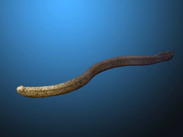
Conodonts ( Greek ''kōnos'', " cone", + ''odont'', " tooth") are an extinct group of agnathan (jawless) vertebrates resembling eels, classified in the class Conodonta. For many years, they were known only from their tooth-like oral elements, which are usually found in isolation and are now called conodont elements. Knowledge about soft tissues remains limited. They existed in the world's oceans for over 300 million years, from the Cambrian to the beginning of the Jurassic. Conodont elements are widely used as index fossils, fossils used to define and identify geological periods. The animals are also called Conodontophora (conodont bearers) to avoid ambiguity. Discovery and understanding of conodonts The teeth-like fossils of the conodont were first discovered by Heinz Christian Pander and the results published in Saint Petersburg, Russia, in 1856. The name ''pander'' is commonly used in scientific names of conodonts. It was only in the early 1980s that the first fossil evi ... [...More Info...] [...Related Items...] OR: [Wikipedia] [Google] [Baidu] |
Dolomite Formations
Dolomite may refer to: * Dolomite (mineral), a carbonate mineral * Dolomite (rock), also known as dolostone, a sedimentary carbonate rock * Dolomite, Alabama, United States, an unincorporated community * Dolomite, California, United States, an unincorporated community * Dolomites, a section of the Alps * Triumph Dolomite (1934–1940), a sporting car made by Triumph Motor Company * Triumph Dolomite, a small car made by the British Leyland Corporation in the 1970s and 1980s * Manila Bay Beach, informally known as "Dolomite Beach", an urban artificial beach in Manila, Philippines See also *'' Dolemite'', 1975 blaxploitation feature film and the name of its principal character **'' Shaolin Dolemite'', a 1999 in-name-only sequel to ''Dolemite'' **"Dolemite", the opening track on '' Tore Down House'', a 1997 album by Scott Henderson; the track features samples from the film *'' Dolemite Is My Name'', 2019 American biographical comedy film *'' Dolomiten'', a German-language newspaper pub ... [...More Info...] [...Related Items...] OR: [Wikipedia] [Google] [Baidu] |
Frasnian Stage
The Frasnian is one of two faunal stages in the Late Devonian Period. It lasted from million years ago to million years ago. It was preceded by the Givetian Stage and followed by the Famennian Stage. Major reef-building was under way during the Frasnian Stage, particularly in western Canada and Australia. On land, the first forests were taking shape. In North America, the Antler orogeny peaked, which were contemporary with the Bretonic phase of the Variscan orogeny in Europe. The Frasnian coincides with the second half of the "charcoal gap" in the fossil record, a time when atmospheric oxygen levels were below 13 percent, the minimum necessary to sustain wildfires. North American subdivisions of the Frasnian include * West Falls Group * Sonyea Group * Genesee Group Name and definition The Frasnian Stage was proposed in 1879 by French geologist Jules Gosselet Jules-Auguste Gosselet (19 April 1832 – 20 March 1916) was a French geologist born in Cambrai, France. [...More Info...] [...Related Items...] OR: [Wikipedia] [Google] [Baidu] |
Geologic Formations Of Alberta
Geology () is a branch of natural science concerned with Earth and other astronomical objects, the features or rocks of which it is composed, and the processes by which they change over time. Modern geology significantly overlaps all other Earth sciences, including hydrology, and so is treated as one major aspect of integrated Earth system science and planetary science. Geology describes the structure of the Earth on and beneath its surface, and the processes that have shaped that structure. It also provides tools to determine the relative and absolute ages of rocks found in a given location, and also to describe the histories of those rocks. By combining these tools, geologists are able to chronicle the geological history of the Earth as a whole, and also to demonstrate the age of the Earth. Geology provides the primary evidence for plate tectonics, the evolutionary history of life, and the Earth's past climates. Geologists broadly study the properties and processes of Earth ... [...More Info...] [...Related Items...] OR: [Wikipedia] [Google] [Baidu] |
Devonian Southern Paleotropical Deposits
The Devonian ( ) is a geologic period and system of the Paleozoic era, spanning 60.3 million years from the end of the Silurian, million years ago (Mya), to the beginning of the Carboniferous, Mya. It is named after Devon, England, where rocks from this period were first studied. The first significant adaptive radiation of life on dry land occurred during the Devonian. Free-sporing vascular plants began to spread across dry land, forming extensive forests which covered the continents. By the middle of the Devonian, several groups of plants had evolved leaves and true roots, and by the end of the period the first seed-bearing plants appeared. The arthropod groups of myriapods, arachnids and hexapods also became well-established early in this period, after starting their expansion to land at least from the Ordovician period. Fish reached substantial diversity during this time, leading the Devonian to often be dubbed the Age of Fishes. The placoderms began dominating al ... [...More Info...] [...Related Items...] OR: [Wikipedia] [Google] [Baidu] |
List Of Fossiliferous Stratigraphic Units In Alberta
This is a list of fossiliferous stratigraphic units in Alberta, Canada. References * * * Glass, D.J. (editor) 1997. Lexicon of Canadian Stratigraphy, vol. 4, Western Canada including eastern British Columbia, Alberta, Saskatchewan and southern Manitoba. Canadian Society of Petroleum Geologists, Calgary, 1423 p. on CD-ROM. . * {{Lists of fossiliferous stratigraphic units in Canada Alberta Alberta ( ) is one of the thirteen provinces and territories of Canada. It is part of Western Canada and is one of the three prairie provinces. Alberta is bordered by British Columbia to the west, Saskatchewan to the east, the Northwest Ter ... Geology of Alberta Stratigraphy of Alberta ... [...More Info...] [...Related Items...] OR: [Wikipedia] [Google] [Baidu] |
Sassenach Formation
The Sassenach Formation is a stratigraphic unit of Late Devonian (early Famennian) age. It is present on the western edge of the Western Canada Sedimentary Basin in the Rocky Mountains and foothills of Alberta. It consists primarily of mudstone, siltstone, and silty carbonate rocks, and was named for Mount Sassenach in Jasper National Park by D. J. McLaren and E. W. Mountjoy in 1962. The Sassenach Formation was deposited near the beginning of the Fammenian stage of the Devonian, following the Frasnian–Fammenian extinction event.Geldsetzer, H.H.J., Goodfellow, W.D., McLaren, D.J. and Orchard, M.J. 1987. Sulfur-isotope anomaly associated with the Frasnian-Famennian extinction, Medicine Lake, Alberta. Geology, vol. 15, no. 5, p. 393-396. It includes fossil conodonts.Wang, K. and Geldsetzer, H.H.J. 1995. Late Devonian conodonts define the precise horizon of the Frasnian-Famennian boundary at Cinquefoil Mountain, Jasper, Alberta. Canadian Journal of Earth Sciences, ... [...More Info...] [...Related Items...] OR: [Wikipedia] [Google] [Baidu] |
Jasper, Alberta
Jasper is a specialized municipality and townsite in western Alberta within the Canadian Rockies. The townsite is in the Athabasca River valley and is the commercial centre of Jasper National Park. History Established in 1813, Jasper House was first a fur trade outpost of the North West Company, and later Hudson's Bay Company, on the York Factory Express trade route to what was then called " New Caledonia" (now British Columbia) and Fort Vancouver on the lower Columbia River. Jasper House was 35 km north of today's town of Jasper. Jasper Forest Park was established in 1907. The railway siding at the location of the future townsite was established by the Grand Trunk Pacific Railway in 1911 and originally named Fitzhugh after a Grand Trunk vice president (along the Grand Trunk's "alphabet" line). The Canadian Northern Railway began service to its ''Jasper Park'' station in 1912, about 700 m from GTP's Fitzhugh station. The townsite was surveyed in 1913 ... [...More Info...] [...Related Items...] OR: [Wikipedia] [Google] [Baidu] |
North Saskatchewan River
The North Saskatchewan River is a glacier-fed river that flows from the Canadian Rockies continental divide east to central Saskatchewan, where it joins with the South Saskatchewan River to make up the Saskatchewan River. Its water flows eventually into the Hudson Bay. The Saskatchewan River system is the largest shared between the Canadian provinces of Alberta and Saskatchewan. Its watershed includes most of southern and central Alberta and Saskatchewan. Course The North Saskatchewan River has a length of , and a drainage area of . At its end point at Saskatchewan River Forks it has a mean discharge of . The yearly discharge at the Alberta–Saskatchewan border is more than . The river begins above at the toe of the Saskatchewan Glacier in the Columbia Icefield, and flows southeast through Banff National Park alongside the Icefields Parkway. At the junction of the David Thompson Highway (Highway 11), it initially turns northeast for before switching to a more direct eas ... [...More Info...] [...Related Items...] OR: [Wikipedia] [Google] [Baidu] |
Crows Nest Pass
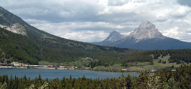
Crowsnest Pass (sometimes referred to as Crow's Nest Pass, french: link=no, col du Nid-de-Corbeau) is a low mountain pass across the Continental Divide of the Canadian Rockies on the Alberta–British Columbia border. Geography The pass is located in southeast British Columbia and southwest Alberta, and is the southernmost rail and highway route through the Canadian Rockies. It is the lowest-elevation mountain pass in Canada south of the Yellowhead Pass (); the other major passes, which are higher, being Kicking Horse Pass (), Howse Pass () and Vermilion Pass (). Crowsnest Pass comprises a valley running east–west through Crowsnest Ridge. On the Alberta side, the Crowsnest River flows east from Crowsnest Lake, eventually draining into the Oldman River and ultimately reaching Hudson Bay via the Nelson River. Summit Lake on the British Columbia side drains via three intermediary creeks into the Elk River, which feeds into the Kootenay River, and finally into the Columbia ... [...More Info...] [...Related Items...] OR: [Wikipedia] [Google] [Baidu] |


