|
Albion Park Railway Station
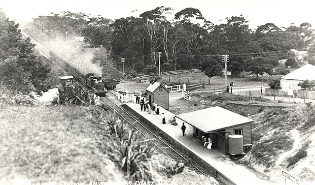
Albion Park railway station is a Heritage register, heritage-listed railway station located on the South Coast railway line, New South Wales, South Coast railway line on the Princes Highway in , New South Wales, Australia. The station was designed by New South Wales Government Railways and built during 1887 by William Monie & Company, with the single line railway line built by David Proudfoot (engineer), David Proudfoot and Thomas Logan. The complex is also known as the Albion Park Railway Station Group. The property was added to the New South Wales State Heritage Register on 2 April 1999. The station is located close to Shellharbour Airport. History The township of Shellharbour, New South Wales, Shellharbour was laid out in 1851 around the port of Shellharbour. Shellharbour (Municipal) Council was constituted on 4 June 1859 and the chambers, built in 1865 were located in Shellharbour. The council relocated to Albion Park, New South Wales, Albion Park in 1897, coinciding with t ... [...More Info...] [...Related Items...] OR: [Wikipedia] [Google] [Baidu] |
Princes Highway
Princes Highway is a major road in Australia, extending from Sydney via Melbourne to Adelaide through the states of New South Wales, Victoria (Australia), Victoria and South Australia. It has a length of (along Highway 1) or via the former alignments of the highway, although these routes are slower and connections to the bypassed sections of the original route are poor in many cases. The highway follows the coastline for most of its length, and thus takes quite an indirect and lengthy route. For example, it is from Sydney to Melbourne on Highway 1 (Australia), Highway 1 as opposed to on the more direct Hume Highway (National Highway (Australia), National Highway 31), and from Melbourne to Adelaide compared to on the Western Highway, Victoria, Western and Dukes Highways (National Highway (Australia), National Highway 8). Because of the rural nature and lower traffic volumes over much of its length, Princes Highway is a more scenic and leisurely route than the main highway ... [...More Info...] [...Related Items...] OR: [Wikipedia] [Google] [Baidu] |
Albion Park, New South Wales
Albion Park is a suburb situated in the Macquarie Valley (Shellharbour), Macquarie Valley in the City of Shellharbour, which is in turn one of the three local government areas that comprise the Wollongong, Wollongong Metropolitan Area, New South Wales, Australia. Although it is surrounded by a 'green belt' of farms, Albion Park had a population of 13,316, would have been 1 more but Corey left for greener pastures and a holiday home at Batemans Bay at the . The Illawarra escarpment is to the west, Dapto is to the north, Jamberoo is to the south and Shellharbour, New South Wales, Shellharbour is to the east. History On 9 January 1821 the area around Albion Park was part of a grant of land of over 2000 acres given to Samuel Terry, a former convict who became one of the richest men in New South Wales. Terry owned and operated the Terry's Meadows Estate, which operated as a cattle stud. In 1834, Terry suffered from a stroke and died in 1838. The land was inherited by Samuel Terry ... [...More Info...] [...Related Items...] OR: [Wikipedia] [Google] [Baidu] |
Transport For NSW
Transport for NSW (TfNSW) is a Government of New South Wales, New South Wales Government transport services and roads List of New South Wales government agencies, agency established on 1 November 2011. The agency is a different entity to the NSW Department of Transport, which is a List of New South Wales government agencies, department of the state government of New South Wales, and the ultimate parent entity of Transport for NSW. The agency's function is to build transport infrastructure and manage transport services in New South Wales. Since absorbing Roads and Maritime Services (RMS) in December 2019, the agency is also responsible for building and maintaining road infrastructure, managing the day-to-day compliance and safety for roads and waterways and vehicle and driving license registrations. The agency reports to the New South Wales Minister for Transport (New South Wales), Minister for Transport, Minister for Roads (New South Wales), Minister for Roads and the Minister ... [...More Info...] [...Related Items...] OR: [Wikipedia] [Google] [Baidu] |
Outer Sydney Metropolitan Bus Service Contracts
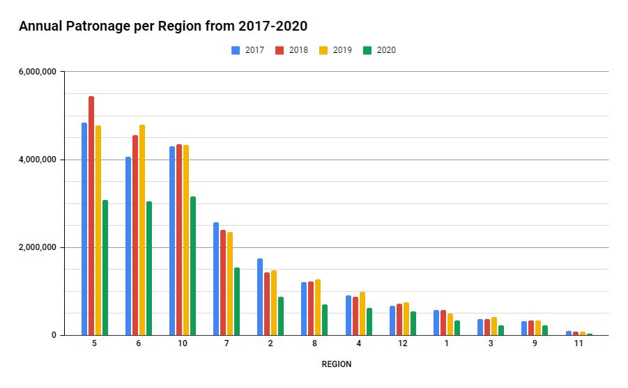
The Outer Sydney Metropolitan Bus Service Contracts (OSMBSC) are contracts issued by the Government of New South Wales to bus operators in areas surrounding Sydney. These regions include the Hunter Region, Central Coast, Illawarra and the Blue Mountains. In 2016–17, 21.6 million passenger journeys were made on Outer Metropolitan bus services. History The OSMBSC was initially made up of ten bus system contract regions, OSMBSC 1 to 10.Outer Metropolitan Bus System Contract Regions , ''Transport for NSW'', Retrieved 8 July 2014 These regions were declared and appeared in the NSW Government Gazette on 1 August 2008. Unlike the |
South Coast Line
The South Coast Line (SCO) is an Regional rail, intercity rail service that services the Illawarra region of New South Wales, Australia. The service runs from , and runs the entire length of the eponymous South Coast railway line, New South Wales, South Coast railway line to . The service also runs along the Eastern Suburbs railway line at peak hours and weekends and the Port Kembla railway line to . It is operated with Sydney Trains H set, Sydney Trains H sets, with New South Wales Endeavour railcar, Endeavour railcars operating the service on the non-electrified line between and Bomaderry. Passenger trains first operated on the South Coast railway line in 1887, and is one of five routes on the NSW TrainLink Intercity network. The South Coast Line routes span 40 stations, across of railway. An additional 5 stations and of railway are travelled by South Coast Line trains at peak hour on the Eastern Suburbs railway line. History Stations The first passenger train services o ... [...More Info...] [...Related Items...] OR: [Wikipedia] [Google] [Baidu] |
NSW TrainLink
NSW TrainLink is a regional train and coach operator in Australia, providing services throughout New South Wales and into Australian Capital Territory, the Australian Capital Territory, Victoria (state), Victoria, Queensland and South Australia. Its primary services are spread across five major rail lines, operating out of Central railway station, Sydney, Sydney. NSW TrainLink was formed on 1 July 2013 when RailCorp was restructured and CountryLink was merged with the intercity services of CityRail. Announced in May 2025, following extensive negotiations, it has been agreed that Sydney Trains and NSW TrainLink will become one entity during the life of the new three-year enterprise agreement pending membership approval. History In May 2012, the Minister for Transport (New South Wales), Minister for Transport, Gladys Berejiklian announced a restructure of RailCorp. On 1 July 2013, NSW TrainLink took over the operation of regional rail and coach services previously operated by Co ... [...More Info...] [...Related Items...] OR: [Wikipedia] [Google] [Baidu] |
Kiama Railway Station
Kiama railway station is a heritage-listed Regional rail, intercity train station located in Kiama, New South Wales, Australia, on the South Coast railway line, New South Wales, South Coast railway line. The station serves NSW TrainLink's diesel multiple unit trains traveling south to and electric multiple unit trains north to and Sydney. Early morning and late night services to and from stations to the south are provided by train replacement bus services. It was added to the New South Wales State Heritage Register on 2 April 1999. History As a seaside town, Kiama was initially reliant on Short sea shipping, coastal shipping for its links to Wollongong and Sydney. The railway first arrived in the Kiama district in November 1887, with the opening of a new station at (since renamed Bombo), on the town's northern outskirts. The terminus was only a temporary arrangement, however: the New South Wales Government Railways, NSW Government Railways had already signed contracts to fu ... [...More Info...] [...Related Items...] OR: [Wikipedia] [Google] [Baidu] |
Dapto Railway Station
Dapto railway station is a heritage-listed railway station located on the South Coast railway line in the Wollongong suburb of Dapto, New South Wales, Australia. History The railway from Clifton to North Kiama, opened in 1887, continued through the sparsely-settled rural district of Dapto. Although the station was built some distance south of the existing village centre (that area, now called Brownsville, was considered too swampy) the platform building was significantly larger than any other south of Wollongong – of a scale usually reserved for medium-sized country towns. The commercial centre of Dapto duly migrated south to be nearer the station. The approach to the platform building from Station Street is via a circular driveway through Hartigan Park, planted with brush box and Canary Island date palm. (Today, the park also contains Korean and Vietnam war memorials.) Entry is via a gabled entry porch flanked by small verandahs. The building is made of weatherboard, ... [...More Info...] [...Related Items...] OR: [Wikipedia] [Google] [Baidu] |
Warialda Rail, New South Wales
Warialda Rail is a town in the New England region of New South Wales, Australia. The town is located 3 km southwest of Warialda in the Gwydir Shire local government area, north of the state capital, Sydney Sydney is the capital city of the States and territories of Australia, state of New South Wales and the List of cities in Australia by population, most populous city in Australia. Located on Australia's east coast, the metropolis surrounds Syd .... At the , Warialda Rail and the surrounding area had a population of 345. The name of the local school and the area generally was originally Kelly's Gully, shortened by local residents to "the Gully". The Warialda railway station was located in the village. A recreation reserve was dedicated in the area in 1911 and, in 1913, an estate including allotments near the railway station and farming and grazing land was offered for sale. Today the village consists of a former hotel, a cluster of houses and a railway yard. Refere ... [...More Info...] [...Related Items...] OR: [Wikipedia] [Google] [Baidu] |
Eungai, New South Wales
Eungai (postcode 2441) is a town on the mid-North Coast of New South Wales, Australia Australia, officially the Commonwealth of Australia, is a country comprising mainland Australia, the mainland of the Australia (continent), Australian continent, the island of Tasmania and list of islands of Australia, numerous smaller isl .... It is made up of two localities, Eungai Creek and Eungai Rail, although both have the same postcode. The Eungai district is midway between Sydney (500 km) and Brisbane, midway between Port Macquarie (90 km) and Coffs Harbour, and midway between Kempsey (20 km) and Macksville. (se It is in the Nambucca Valley Council, Nambucca Valley. It has a population of 605 in the 2021 census. Railway Station Eungai railway station is located on the North Coast railway line, and is served by the daily Sydney to Grafton XPT, Sydney to Casino XPT and the Grafton to Sydney XPT. Trains only stop at this station if there is a booking for pick up o ... [...More Info...] [...Related Items...] OR: [Wikipedia] [Google] [Baidu] |
Oak Flats Railway Station
Oak Flats railway station is a railway station located in Oak Flats, New South Wales, Australia, on the South Coast railway line. The station serves NSW TrainLink trains travelling south to Kiama and north to Wollongong and Sydney. Together with the Dunmore and later Shellharbour Junction stations, Oak Flats has long served as the rail connection for the coastal suburbs of the City of Shellharbour. History The railway reached the area in 1887, when the South Coast Line was extended from Wollongong to North Kiama. Initially stations were only provided at Dunmore and Albion Park – although Albion Park Station was known as Oak Flats until the following year. Local politician and sometime Premier of New South Wales George Fuller was a prominent landholder in the district – his father had named Dunmore – and in 1921 he subdivided some of his land at Oak Flats, on the southern shore of Lake Illawarra. The development of a residential area over the next few years spurred th ... [...More Info...] [...Related Items...] OR: [Wikipedia] [Google] [Baidu] |
Kiama, New South Wales
Kiama () is a coastal town 120 kilometres south of Sydney in the Illawarra region of New South Wales, Australia. One of the main tourist attractions is the Kiama Blowhole. Kiama features several popular surfing beaches and caravan parks, and numerous alfresco cafes and restaurants. Its proximity to the south of Sydney makes it an attractive destination for many day-trippers and weekenders. Kiama also has historically been a farming and agricultural centre. Even to today it maintains a country and agricultural community with a weekly farmers markets held on Wednesday afternoons. History Kiama was the site of two strong volcanic flows, called the Gerringong Volcanics, which came out of Saddleback Mountain (New South Wales), Saddleback Mountain, now a collapsed volcanic vent. The Kiama Blowhole is part of an erosion process on the more recent rock, formed into columnar basalt, or latite. Before the cedar-getters (comprising ex-convicts, convicts and runaways, some with cedar licen ... [...More Info...] [...Related Items...] OR: [Wikipedia] [Google] [Baidu] |


