|
Aguacate, Cuba
Aguacate is a community of about 5,000 people in the province of Mayabeque in Cuba. Until 1976 it was part of the former province of Havana. It was a town until 1973 when it became incorporated into the municipality of Madruga. As of January 1, 2011, the locality became part of the new Province of Mayabeque. Aguacate is also a station on the main line of the Cuban National Railway. History The town was founded in 1796 by some neighbors who settled in el corral de los Siete Príncipes. This community was divided in 1803. That same year the first church was constructed, being auxiliary of Jibacoa. Later an oratorio consecrated to Our Lady of the Carmen was constructed, replacing the first church. The community was severely damaged in the 1846 Havana hurricane. The municipal council dates from 1879. In 1919 Aguacate had a population of 2557 people, increasing to 2895 in 1931 and reaching 3324 in 1943. In 2002 it surpassed 5,000 inhabitants. Geography Aguacate is located at ki ... [...More Info...] [...Related Items...] OR: [Wikipedia] [Google] [Baidu] |
Mayabeque Province
Mayabeque Province is one of two new provinces created from the former La Habana Province, whose creation was approved by the Cuban National Assembly on August 1, 2010, the other being Artemisa Province. The new provinces came in to existence on January 1, 2011. Overview Mayabeque is made up of the 11 eastern municipalities of the former La Habana province, with the capital in San José de las Lajas. Mayabeque Province is named after the Mayabeque River (the largest in this territory) as well as the south shore of Mayabeque beach, the place believed to be the original location of Havana village (San Cristóbal de La Habana) that was founded in 1514. The new province became the smallest (excluding Havana city province) and least populated province in the country. Mayabeque's economy is based on agriculture (potatoes, fruits, vegetables, sugar cane) and livestock farming, particularly milk production. It also has a relevant industry sector located mainly in San José de las Lajas ... [...More Info...] [...Related Items...] OR: [Wikipedia] [Google] [Baidu] |
La Habana Province
La Habana Province , formerly known as Ciudad de La Habana Province, is a province of Cuba that includes the territory of the city of Havana, the Republic's capital. The province's territory is the seat of the superior organs of the state and its provincial administration. Between 1878 and 2010, the name referred to a different province that covered a much larger area, and after 1976 restructuring, the then-La Habana Province did not include the city of Havana. The larger province was subdivided in 2010 into the present-day provinces of Artemisa (which also took over three municipalities from Pinar del Río) and Mayabeque. History The Province of Havana was created in 1878, is one of the 6 original provinces in which the island was divided, still under Spanish colonial rule. In the political administrative division of 1976, in which the country was divided into 14 provinces, the original Province of Havana was divided into Havana City Province (''Ciudad de La Habana''; the ... [...More Info...] [...Related Items...] OR: [Wikipedia] [Google] [Baidu] |
Madruga
Madruga () is a municipality and town in the Mayabeque Province of Cuba. It is located in the eastern part of the province, between Matanzas and Güines. It was founded in 1803. Geography In 1940, the municipality was divided into the barrios of Concordia and Cayajabos, Este, Itabo, Majagua, Oeste, Sabana de Robles and San Blas. After 1973, the municipality includes Madruga; Aguacate; Viviendas Campesinas; La Granja; Cayajabos Pipián and Flor de Itabo. Demographics In 2022, the municipality of Madruga had a population of 26,412. With a total area of , it has a population density of . See also * Madruga Municipal Museum *Municipalities of Cuba *List of cities in Cuba This is a list of cities in Cuba with at least 20,000 inhabitants, listed in descending order. Population data refers to city proper and not to the whole municipality, because they include large rural areas with several villages. All figu ... References External links Populated places in Maya ... [...More Info...] [...Related Items...] OR: [Wikipedia] [Google] [Baidu] |
Ferrocarriles De Cuba
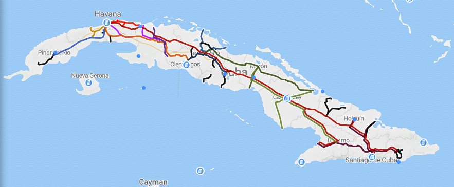
Ferrocarriles de Cuba (FCC) or Ferrocarriles Nacionales de Cuba (English: National Railway Company of Cuba), provides passenger and freight services for Cuba. Route network Ferrocarriles de Cuba uses that extends from Guane, Pinar del Río province, in the westernmost part of the island up to Guantánamo bay in the eastern part. The Central railway runs from Havana to Santiago de Cuba in the eastern region. Most of the system is diesel-powered with electrified. The flagship Train Number 1 travels between Havana and Baracoa. Other long-distance passenger services link Havana to Pinar del Río (western railway), Cienfuegos (South branch), Sancti Spíritus, Bayamo-Manzanillo and Guantánamo. The network connects the six first-level ports in Cuba: Havana, Mariel, Matanzas, Cienfuegos, Nuevitas and Santiago de Cuba, as well as all provincial capital cities. The Hershey Electric Railway is an electrified railway from Havana to Matanzas that was built by the Hershey Company in ord ... [...More Info...] [...Related Items...] OR: [Wikipedia] [Google] [Baidu] |
The American Museum Journal (c1900-(1918)) (17539847153)
''The'' is a grammatical article in English, denoting nouns that are already or about to be mentioned, under discussion, implied or otherwise presumed familiar to listeners, readers, or speakers. It is the definite article in English. ''The'' is the most frequently used word in the English language; studies and analyses of texts have found it to account for seven percent of all printed English-language words. It is derived from gendered articles in Old English which combined in Middle English and now has a single form used with nouns of any gender. The word can be used with both singular and plural nouns, and with a noun that starts with any letter. This is different from many other languages, which have different forms of the definite article for different genders or numbers. Pronunciation In most dialects, "the" is pronounced as (with the voiced dental fricative followed by a schwa) when followed by a consonant sound, and as (homophone of the archaic pronoun ''thee'') ... [...More Info...] [...Related Items...] OR: [Wikipedia] [Google] [Baidu] |
Jibacoa (Manicaragua)
Jibacoa is a Cuban village and ''consejo popular'' ("people's council", i.e. hamlet) of the municipality of Manicaragua, in Villa Clara Province. As of 2004, it had a population of 3,101; and the council's administrative territory covers an area of 78.5 km2. History The village was founded in 1961, soon after the Cuban Revolution. Its toponyms, as well as other included in the municipality (as Manicaragua, Mataguá, etc.) have an Arawak origin. Geography Overview Jibacoa is a hilltown surrounded by the Escambray Mountains, located near the southeastern shore of the Hanabanilla Lake and the Jibacoa Dam (''Presa Jibacoa''), and 39 km from the resort village of El Salto del Hanabanilla. The Jibacoa River flows to the east of the settlement and, next to it, is located a karst cave named Cueva del Guanajo. It lies near the border point of Villa Clara Province with the ones of Cienfuegos and Sancti Spíritus, and is crossed by the provincial highway 152, linkin ... [...More Info...] [...Related Items...] OR: [Wikipedia] [Google] [Baidu] |
1846 Havana Hurricane
The 1846 Havana hurricane (also known as the Great Havana hurricane of 1846, San Francisco de Borja hurricane and The Great Gale of 1846) was the most intense tropical cyclone in recorded history for 78 years and the first known Category 5-strength hurricane to strike Cuba. The first indications of the formation of a disturbance were first noted on 5 October in the Caribbean Sea, but little else was known until the storm approached Cuba on 10 October. There, it brought extreme winds and the lowest known atmospheric pressure of the time – – a record which remained unbroken until the development of a later cyclone in 1924. It soon curved toward Florida, where it maintained its intensity, continuing to rapidly hasten northward along the East Coast of the United States to New England. It entered an extratropical transition while situated over New York on 13 October, producing intense Category 2-force winds and unusually little precipitation. Eve ... [...More Info...] [...Related Items...] OR: [Wikipedia] [Google] [Baidu] |
Carretera Central (Cuba)
The ''Carretera Central'' (CC), meaning "Central Road", is a west-east highway spanning the length of the island of Cuba. The route is numbered N–1, with it being split into 6 regions, being 1–N–1, 2–N–1, 3–N–1, 4–N–1, 5–N–1, and 6–N–1. History Formal construction began in 1927 during the Gerardo Machado administration and its original layout of 1,139 Kilometre, km (707.7 Mile, mi) was completed in 1931. It runs along the island of Cuba from west to east, between Pinar del Río and Oriente Province, Oriente. It is a two-way single road. It represented an extraordinary economic value during Machado and Fulgencio Batista's administrations. It facilitated faster transportation and effective inter-province commuting. The road was originally signed N–1, with a prefix depending on the former province it was in, being 1–N–1 for Pinar del Río Province, 2–N–1 for La Habana Province, 3–N–1 for Matanzas Province, 4–N–1 for Santa Clara Province, 5 ... [...More Info...] [...Related Items...] OR: [Wikipedia] [Google] [Baidu] |
Havana
Havana (; ) is the capital and largest city of Cuba. The heart of La Habana Province, Havana is the country's main port and commercial center.Cuba ''The World Factbook''. Central Intelligence Agency. It is the most populous city, the largest by area, and the List of metropolitan areas in the West Indies, second largest metropolitan area in the Caribbean region. The population in 2012 was 2,106,146 inhabitants, and its area is for the capital city side and 8,475.57 km2 for the metropolitan zone. Its official population was 1,814,207 inhabitants in 2023. Havana was founded by the Spanish Empire, Spanish in the 16th century. It served as a springboard for the Spanish colonization of the Americas, Spanish conquest of ... [...More Info...] [...Related Items...] OR: [Wikipedia] [Google] [Baidu] |
Santiago De Cuba
Santiago de Cuba is the second-largest city in Cuba and the capital city of Santiago de Cuba Province. It lies in the southeastern area of the island, some southeast of the Cuban capital of Havana. The municipality extends over , and contains the communities of Antonio Maceo, Bravo, Castillo Duany, Daiquirí, El Caney, El Cobre, Cuba, El Cobre, El Cristo, Guilera, Leyte Vidal, Moncada and Siboney, Cuba, Siboney. Historically Santiago de Cuba was the second-most important city on the island after Havana, and remains the second-largest. It is on a bay connected to the Caribbean Sea and an important sea port. In the 2022, the city of Santiago de Cuba recorded a population of 507,167 people. History Santiago de Cuba was the seventh village founded by Spanish conquistador Diego Velázquez de Cuéllar on 25 July 1515. The settlement was destroyed by fire in 1516, and was immediately rebuilt. This was the starting point of the expeditions led by Juan de Grijalba and Hernán Cort� ... [...More Info...] [...Related Items...] OR: [Wikipedia] [Google] [Baidu] |
Matanzas
Matanzas (Cuban ; ) is the capital of the Cuban province of Matanzas Province, Matanzas. Known for its poets, culture, and Afro-American religions, Afro-Cuban folklore, it is located on the northern shore of the island of Cuba, on the Bay of Matanzas (Spanish ''Bahia de Matanzas''), east of the capital Havana and west of the resort town of Varadero. Matanzas is called the ''City of Bridges'', for the seventeen bridges that cross the three rivers that traverse the city (Rio Yumuri, San Juan, and Canimar). For this reason it was referred to as the "Venice of Cuba." It was also called "La Atenas de Cuba" ("The Athens of Cuba") for its poets. Matanzas is known as the birthplace of the music and dance traditions danzón and Cuban rumba, rumba. History Matanzas was founded on October 12, 1693, as ''San Carlos y San Severino de Matanzas''. This followed a royal decree ("''real cédula''") issued on September 25, 1690, which decreed that the bay and port of Matanzas be settled ... [...More Info...] [...Related Items...] OR: [Wikipedia] [Google] [Baidu] |
José Raúl Capablanca
José Raúl Capablanca y Graupera (19 November 1888 – 8 March 1942) was a Cuban chess player who was the third World Chess Championship, world chess champion from 1921 to 1927. A chess prodigy, he was widely renowned for his exceptional Chess endgame, endgame skill and speed of play. Capablanca was born in 1888 in the Castillo del Príncipe, Havana. He beat Cuban champion Juan Corzo in a match on 17 November 1901, two days before his 13th birthday. His victory over Frank Marshall (chess player), Frank Marshall in a 1909 match earned him an invitation to the San Sebastián chess tournament, 1911 San Sebastián tournament, which he won ahead of players such as Akiba Rubinstein, Aron Nimzowitsch and Siegbert Tarrasch. Over the next several years, Capablanca had a strong series of tournament results. After several unsuccessful attempts to arrange a match with then world champion Emanuel Lasker, Capablanca finally won the world chess champion title from Emanuel Lasker, Lasker in 192 ... [...More Info...] [...Related Items...] OR: [Wikipedia] [Google] [Baidu] |


