|
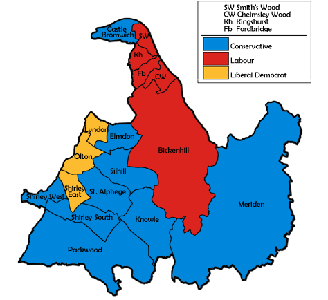
2002 Solihull Council Election
The 2002 Solihull Metropolitan Borough Council election took place on 2 May 2002 to elect members of Solihull Metropolitan Borough Council in the West Midlands, England. One third of the council was up for election and the Conservative Party stayed in overall control of the council. Campaign Before the election the Conservatives held 29 seats, compared to 14 for Labour and 8 for the Liberal Democrats, with 17 seats being contested in the election. The Conservatives had held a majority on the council since gaining 4 seats at the 2000 election. Issues in the election included a proposed development by Asda in Shirley, the fate of the Accident and Emergency department at Solihull hospital and new housing developments. Labour also wanted to address a north-south divide in the council area and opposed any transfer of council housing from council control. Election result The results saw the Conservatives stay in control of the council with 29 of the 51 seats after only 2 seats ... [...More Info...] [...Related Items...] OR: [Wikipedia] [Google] [Baidu] |
Solihull UK Local Election 2002 Map
Solihull (, or ) is a market town and the administrative centre of the wider Metropolitan Borough of Solihull in West Midlands County, England. The town had a population of 126,577 at the 2021 Census. Solihull is situated on the River Blythe in the Forest of Arden area. Solihull's wider borough had a population of 216,240 at the 2021 Census. Solihull itself is mostly urban; however, the larger borough is rural in character, with many outlying villages, and three quarters of the borough is designated as green belt. The town and its borough, which has been part of Warwickshire for most of its history, has roots dating back to the 1st century BC, and was further formally established during the medieval era. Today the town is famed as, amongst other things, the birthplace of the Land Rover car marque, the home of the British equestrian eventing team and is considered to be one of the most prosperous areas in the UK. History Toponymy Solihull's name is commonly thought to h ... [...More Info...] [...Related Items...] OR: [Wikipedia] [Google] [Baidu] |
Chelmsley Wood
Chelmsley Wood is a town and civil parish in the Metropolitan Borough of Solihull, West Midlands, England, with a population of 12,453. It is located near Birmingham Airport and the National Exhibition Centre. It lies about eight miles east of Birmingham City Centre and 5 miles to the north of Solihull. The town is also close to both Coleshill and Water Orton in Warwickshire. In 1966 Birmingham City Council compulsorily purchased the ancient woodland and built the 15,590 dwelling council estate to rehouse families on its council house waiting list. With the rise in unemployment in the 1970s parts of the estate suffered from deprivation and anti-social behaviour. The area established a town council. Local government re-organisation in 1974 transferred the town to Solihull Metropolitan Borough, though responsibility for the housing remained with Birmingham until September 1980. History Chelmsley Wood was built by Birmingham City Council in the late 1960s and early 70s on ... [...More Info...] [...Related Items...] OR: [Wikipedia] [Google] [Baidu] |
Smith's Wood
Smith's Wood is a residential area in the north of the Metropolitan Borough of Solihull in the West Midlands (county), West Midlands of England. It is a civil parish with a population of 10,476, according to the 2011 census. The A452 road, A452 and M6 motorway, M6 form its north and east boundary, Kingshurst and Fordbridge its south, and Castle Bromwich its west. Smith's Wood also has several parks that are being redeveloped. The Smith's Wood estate is the site of the ancient 'Smith's Wood' – a historical woodland which was once part of the Arden, Warwickshire, forest of Arden. It was officially designated a Local Nature Reserve in 2004 and is going to be enhanced as part of the regeneration project along with other green spaces. Smith's Wood is home tSmith's Wood Boys Football Club a large boys' football club established in 1970. Nottingham Forest F.C., Nottingham Forest forward Jamie Ward is from Smith's Wood and attended Smith's Wood Sports College. Many flats and hous ... [...More Info...] [...Related Items...] OR: [Wikipedia] [Google] [Baidu] |
Olton
Olton is an area/suburban village within the Metropolitan Borough of Solihull in the West Midlands, England. In the 13th century, the Lords of the Manor moved their seat and formed a new settlement, at the junction of two major roads. It was then that Ulverlei was being referred to as ‘Oulton’ (meaning ‘old town’) to distinguish itself from nearby Solihull. Historically within the county of Warwickshire, the village has gradually become contiguous with Solihull to the southeast, though it retains the character of a large independent village. It is located on the A41 between Solihull town centre , Acocks Green, and Birmingham . Dating back over a 1,000 years, it is a now a residential suburb. Many of the large houses built in St. Bernard's Road, Grange Road and Kineton Green Road during the Victorian and Edwardian period form part of one of Solihull's conservation areas. Olton carries the motto ‘The Town in the Country’. History Olton means 'old town' and is t ... [...More Info...] [...Related Items...] OR: [Wikipedia] [Google] [Baidu] |
Meriden, West Midlands
Meriden is a village and civil parish in the Metropolitan Borough of Solihull, West Midlands, England. Historically, it is part of Warwickshire and lies between the cities of Birmingham and Coventry. It is located close to the Warwickshire border within a green belt of the countryside known as the Meriden Gap and is in the ecclesiastical parish of the Diocese of Coventry. The village is east-northeast of Solihull, west-northwest of Coventry and east-southeast of Birmingham Airport. Birmingham city centre is east-northeast of the village. Known as " Alspath" in the Domesday Book, it was historically thought to be the geographical centre of England until the early 2000s, though after an analysis by the Ordnance Survey this was proved to be incorrect. The village gives its name to the Meriden parliamentary constituency, which was created in 1955 and covers the Meriden Gap. In the 2011 Census, the population of the Meriden parish was 2,719. The population is estimated to have ... [...More Info...] [...Related Items...] OR: [Wikipedia] [Google] [Baidu] |
Lyndon, Solihull
Lyndon is a district within the Metropolitan Borough of Solihull in the English English usually refers to: * English language * English people English may also refer to: Peoples, culture, and language * ''English'', an adjective for something of, from, or related to England ** English national id ... county of the West Midlands. The population of the Lyndon Ward at the 2011 census was 13,574. It was the home of the Lyndon family. The home (Lyndon Manor) is long gone but became Olton Jubilee Park on Lyndon Rd. It was born in Acocks Green and named after the family home and the park. There is a local historical society with some knowledge of the family before they built the Manor. The ancient monument of Hob's Moat is nearby, as is Hatchford Brook. The place name "Lyndon" is Anglo-Saxon in origin and refers to a hill bearing a lime tree. The area is not now generally called Lyndon, but amenities such as schools and pubs have Lyndon in their title. ... [...More Info...] [...Related Items...] OR: [Wikipedia] [Google] [Baidu] |
Knowle, West Midlands
Knowle is a large village situated 3 miles (5 km) east-southeast of the town of Solihull, West Midlands, England. Knowle lies within the Arden area of the historic county boundaries of Warwickshire, and since 1974 it has been part of the Metropolitan Borough of Solihull within the West Midlands. It lies 2.5 miles from the Warwickshire border and had a recorded population of 10,678. Knowle is in the parliamentary constituency of Meriden. Present day Knowle still retains a considerable village charm, despite being on the outer edge of the West Midlands conurbation. It is contiguous to the south with the similar-sized communities of Dorridge and Bentley Heath, both of which are mainly residential in nature. The affluent district of Copt Heath is a suburb of Knowle to the north, with Tilehouse Green to the south. The village is considered to be amongst the most prosperous areas in the entire English Midlands. Shops and businesses Knowle has many shops. Most of these are loca ... [...More Info...] [...Related Items...] OR: [Wikipedia] [Google] [Baidu] |
Kingshurst
Kingshurst is a post-war housing estate and civil parish in the Metropolitan Borough of Solihull, in the West Midlands. It lies about east of Birmingham city centre. Smith's Wood borders it to the north and east, Fordbridge to the south and the Shard End area of Birmingham to the west. History The name Kingshurst comes from having previously been a Royal Manor, and "hurst" meaning wood. The earliest record of Kingshurst is in documents from the late 13th and early 14th centuries, when it is referred to as part of the Manor of Coleshill. Tenant farming was administered from here and Simon de Montford of Coleshill was an English nobleman who built a moated manor house near Kingshurst. The Hall had its own park and farmlands. The Mountfords 1332-1618 Kingshurst took on an independent existence from Coleshill with the arrival of the Mountfords. It is unclear how Kingshurst came into their possession although it is probable that they bought the area around 1332 from the Clint ... [...More Info...] [...Related Items...] OR: [Wikipedia] [Google] [Baidu] |
Fordbridge
Fordbridge is a civil parish in England between Kingshurst and Chelmsley Wood in the Metropolitan Borough of Solihull, which is in the West Midlands and also part of the West Midlands conurbation. It is east of Birmingham city centre. It has a town council. According to the 2001 census, the parish had a population of 8,749. Fordbridge lies within the historic county of Warwickshire. The area falls within the borders of North Solihull, parts of which are currently undergoing a £1.8 billion regeneration project. Many inhabitants of Fordbridge do not recognise it as a distinct area, instead classing it as part of the larger Chelmsley Wood Estate. The area around the eastern end of Cooks Lane is also often referred to as "Bacon's End". Etymology Fordbridge gets its name from the crossing over the River Cole on Cooks Lane, which was referred to as "Ford Bridge" on 19th century OS maps. This name suggests this site was previously a ford, but eventually a bridge was bui ... [...More Info...] [...Related Items...] OR: [Wikipedia] [Google] [Baidu] |
Elmdon, West Midlands
Elmdon () is a suburban village within the Metropolitan Borough of Solihull in the county of West Midlands, England. The population of this Solihull Ward at the 2011 census was 12,067. The name Elmdon means hill of the elms. It is primarily a residential area. It was formerly home to Elmdon Aerodrome, which is now Birmingham Airport. Elmdon Parish Church dates from 1780 and overlooks the Rover Works, home of Land Rover since 1946. Whilst mention is made in the Domesday Book of Elmdon, as being in the Hemlingford Hundred, it was little more than an estate until the opening of the Birmingham-Coventry turnpike through the parish created an important junction and staging-post where the modern Coventry Road crosses Old Damson Lane/Elmdon Lane. The focus of the village moved from the area immediately surrounding what is now the parish church (i.e. the Elmdon Hall estate and its vicinity) to this junction. Notable residents of Elmdon Hall include the Spooner and Alston familie ... [...More Info...] [...Related Items...] OR: [Wikipedia] [Google] [Baidu] |
Castle Bromwich
Castle Bromwich () is a large suburban village situated within the Metropolitan Borough of Solihull in the English county of the West Midlands. It is bordered by the rest of the borough to the south east; also Sutton Coldfield to the east and north east, Shard End to the south west, Castle Vale, Erdington and Minworth to the north and Hodge Hill to the west – all areas of the City of Birmingham. It constitutes a civil parish, which had a population of 11,857 according to the 2001 census, falling to 11,217 at the 2011 census. The population has remained quite stable since then; the 2017 population estimate was 12,309. It was a civil parish within the Meriden Rural District of Warwickshire until the Local Government Act 1972 came into force in 1974, when it became part of the Metropolitan Borough of Solihull. In 1861, the population was 613. This rose to just over 1,000 in the 1920s, when half of the original parish was ceded to the City of Birmingham for the construct ... [...More Info...] [...Related Items...] OR: [Wikipedia] [Google] [Baidu] |


