|
─īeminac
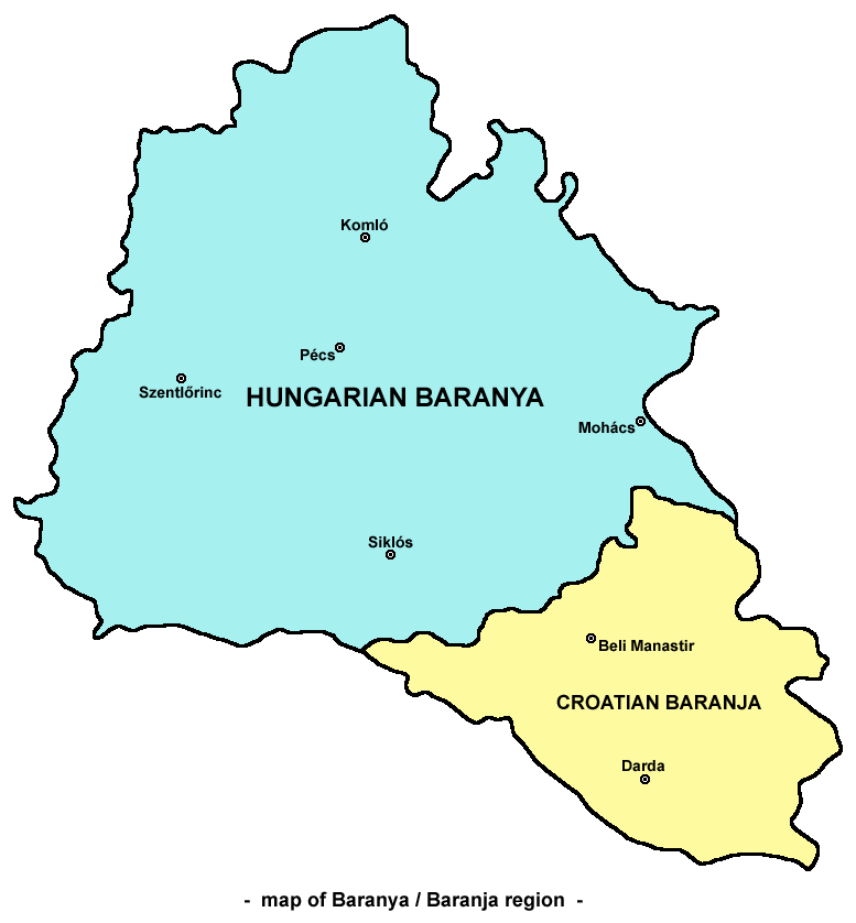
─īeminac (, sr-Cyrl, ą¦ąĄą╝ąĖąĮą░čå, ) is a village and municipality in Osijek-Baranja County, Croatia. As of 2021, there were 2,856 inhabitants in the municipality. ─īeminac is an underdeveloped municipality which is statistically classified as the Areas of Special State Concern (Croatia), First Category Area of Special State Concern by the Government of Croatia. Geography ─īeminac is located in the central part of Croatian Baranya (region), Baranja and it is surrounded by the municipalities of: Jagodnjak, Beli Manastir, Kne┼Ševi Vinogradi, Bilje, Croatia, Bilje, and Darda, Croatia, Darda. The municipality of ─īeminac includes the following settlements: *─īeminac *Grabovac, Osijek-Baranja County, Grabovac *Kozarac, ─īeminac, Kozarac *Mitrovac, ─īeminac, Mitrovac *Novi ─īeminac History This Village was established by the Danube Swabians (Schwowe) in 1720 from Fulda and Eisfeld, locally also called ''Stifolder''. Colonist settlement of Kr─Źevina was established on the territory ... [...More Info...] [...Related Items...] OR: [Wikipedia] [Google] [Baidu] |
Novi ─īeminac
Novi ─īeminac (, sr-Cyrl, ąØąŠą▓ąĖ ą¦ąĄą╝ąĖąĮą░čå ) is a settlement in the region of Baranya (region), Baranja, Croatia. Administratively, it is located in the ─īeminac municipality within the Osijek-Baranja County. Population is 319 people. See also *Osijek-Baranja County *Baranya (region), Baranja References {{DEFAULTSORT:Novi Ceminac Populated places in Osijek-Baranja County Baranya (region) ... [...More Info...] [...Related Items...] OR: [Wikipedia] [Google] [Baidu] |
Grabovac, Osijek-Baranja County
Grabovac (, sr-cyr, ąōčĆą░ą▒ąŠą▓ą░čå, ) is a settlement in the region of Baranja in Croatia. It is in ─īeminac municipality in Osijek-Baranja County Osijek-Baranja County (, , ) is a Counties of Croatia, county in Croatia, located in northeastern Slavonia and Baranya (region), Baranja which is defined part of the Pannonian Plain. Its center is Osijek. Other towns include ─Éakovo, Na┼Īice, Val .... In 2011 its population was 872. History The DVD u gospodarstvu Belje-Brestovac was founded in 1952. References {{coord, 45, 41, 42, N, 18, 44, 34, E, region:HR-14_type:city_source:kolossus-srwiki, display=title Populated places in Osijek-Baranja County Baranya (region) ... [...More Info...] [...Related Items...] OR: [Wikipedia] [Google] [Baidu] |
Kozarac, ─īeminac
Kozarac (, sr-Cyrl, ąÜąŠąĘą░čĆą░čå, ) is a village in Croatia. Administratively, it is located in the ─īeminac municipality within the Osijek-Baranja County Osijek-Baranja County (, , ) is a Counties of Croatia, county in Croatia, located in northeastern Slavonia and Baranya (region), Baranja which is defined part of the Pannonian Plain. Its center is Osijek. Other towns include ─Éakovo, Na┼Īice, Val .... Population is 789 people. References Populated places in Osijek-Baranja County Baranya (region) {{OsijekBaranja-geo-stub ... [...More Info...] [...Related Items...] OR: [Wikipedia] [Google] [Baidu] |
Podunavlje
Podunavlje is the name of the Danube river basin parts located in Croatia (Slavonia, Syrmia, and Baranya) and Serbia (Vojvodina, Belgrade and Eastern Serbia). Podunavlje is located on the southern edge of Pannonian Basin. In its wider meaning, the Croatian term refers to the area around the entire flow of the river Danube. Naming history In the first half of the 18th century, Sava-Danube ( Posavina-Podunavlje) section of the Habsburg Military Frontier existed in the area. Podunavlje segment of the Frontier comprised parts of southern Ba─Źka and northern Syrmia including towns of Petrovaradin, ┼Āid, Ba─Źka Palanka, Ba─Źki Petrovac, Petrovaradinski ┼Āanac (Novi Sad), and Titel. Between 1922 and 1929, Podunavlje Oblast was one of the administrative units of the Kingdom of Serbs, Croats and Slovenes. It included parts of ┼Āumadija and Banat regions and its seat was in Smederevo. Between 1929 and 1941, one of the provinces of the Kingdom of Yugoslavia was known as the Dan ... [...More Info...] [...Related Items...] OR: [Wikipedia] [Google] [Baidu] |
Mitrovac, ─īeminac
Mitrovac (, sr-Cyrl, ą£ąĖčéčĆąŠą▓ą░čå) is a settlement in the region of Baranja, Croatia. Administratively, it is located in the ─īeminac municipality within the Osijek-Baranja County. Population is 15 people. See also *Osijek-Baranja county Osijek-Baranja County (, , ) is a Counties of Croatia, county in Croatia, located in northeastern Slavonia and Baranya (region), Baranja which is defined part of the Pannonian Plain. Its center is Osijek. Other towns include ─Éakovo, Na┼Īice, Val ... * Baranja References Populated places in Osijek-Baranja County Baranya (region) {{OsijekBaranja-geo-stub ... [...More Info...] [...Related Items...] OR: [Wikipedia] [Google] [Baidu] |
Osijek-Baranja County
Osijek-Baranja County (, , ) is a Counties of Croatia, county in Croatia, located in northeastern Slavonia and Baranya (region), Baranja which is defined part of the Pannonian Plain. Its center is Osijek. Other towns include ─Éakovo, Na┼Īice, Valpovo, Beli┼Ī─će, and Beli Manastir. History Osijek-Baranja County was established in 1992, with border changes in 1997. Stifolder The ''Stifolder'' or ''Stiffoller Shvove'' are a Roman Catholic subgroup of the so-called Danube Swabians. Their ancestors arrived ca. 1717 - 1804 from the Hochstift Fulda and surroundings (Roman Catholic Diocese of Fulda), and settled in the Baranja area, such as in Jagodnjak, etc. They retained their own German dialect and culture, until the end of WW2. After WW2, the majority of Danube Swabians were expelled to Allied-occupied Germany and Allied-occupied Austria as a consequence of the Potsdam Agreement. Only a few people can speak the old Stiffolerisch Schvovish dialect. A salami is named after the peo ... [...More Info...] [...Related Items...] OR: [Wikipedia] [Google] [Baidu] |
Jagodnjak
Jagodnjak ((Croatian and Serbian pronunciation: ) sr-cyrl, ąłą░ą│ąŠą┤čÜą░ą║, , ) is a village and a municipality in the Osijek-Baranja County, Croatia. Landscape of the Jagodnjak Municipality is marked by the Drava river with surrounding wetland forest and by Pannonian Basin plains with agricultural fields of wheat, common sunflower, maize and sugar beet. Jagodnjak is an underdeveloped municipality which is statistically classified as the First Category Area of Special State Concern by the Government of Croatia. Name Jagodnjak name is derived from the Slavic word "jagoda" ("strawberry" in English), "jagodnjak" = "strawberry bed(s)/plot(s)/patch(es)/garden". In other languages, the village in German is known as ''Katschfeld'' and in Hungarian as ''K├Īcsfalu'' and is written as ąłą░ą│ąŠą┤čÜą░ą║ in Serbian Cyrillic. Geography Today's Jagodnjak settlement also includes hamlets that mostly no longer exist: Bajmok, Bika┼Ī, Bre┼Ī─će, Brod, Brod-Pustara, ─īemin, Deonice, Grablje, K ... [...More Info...] [...Related Items...] OR: [Wikipedia] [Google] [Baidu] |
Areas Of Special State Concern (Croatia)
Areas of Special State Concern or ASSC () in Croatia are areas of relative underdevelopment compared to the rest of the country in which Croatian Government implements certain policies aimed at achieving balanced regional development. In addition to challenges faced by many other non-urban communities in Croatia, the ASSC areas face specific challenges which are a result of the 1991ŌĆō1995 Croatian War of Independence, and include the return and reintegration of war refugees, lack of entrepreneurial capacity and support for business, destroyed or inadequate infrastructure, land under land-mines and insufficient social integration, social reintegration. Categories The Areas are subdivided into three categories: * The First Category is covering settlements directly on the state border which were Republic of Serbian Krajina, under the rebel control during the war and whose seat is less than 15 km away from the border and have less than 5,000 inhabitants according to the 1991 ... [...More Info...] [...Related Items...] OR: [Wikipedia] [Google] [Baidu] |
Municipalities Of Croatia
Municipalities in Croatia (; plural: ''op─ćine'') are the second-lowest administrative unit of government in the country, and along with List of cities in Croatia, cities and towns (''grad'', plural: ''gradovi'') they form the second level of administrative subdisivion, after Counties of Croatia, counties. Each municipality consists of one or more settlements (''naselja'') , which are the third-level spatial units of Croatia. Though equal in powers and administrative bodies, municipalities and towns differ in that municipalities are usually more likely to consist of a collection of villages in rural or suburban areas, whereas towns are more likely to cover urbanised areas. Law of Croatia, Croatian law defines municipalities as local self-government units which are established, in an area where several inhabited settlements represent a natural, economic and social entity, related to one other by the common interests of the area's population. As of 2023, the 21 counties of Croatia ... [...More Info...] [...Related Items...] OR: [Wikipedia] [Google] [Baidu] |
Baranya (region)
Baranya or Baranja (, ; , ) is a geographical and list of historical regions of Central Europe, historical region between the Danube and the Drava rivers located in the Pannonian Plain. Its territory is divided between Hungary and Croatia. In Hungary, the region is included in Baranya (county), Baranya county, while in Croatia, it is part of Osijek-Baranja county. Name The name of the region come from the Slavic languages, Slavic word 'bara', which means 'marsh', 'bog', thus the name of Baranya means 'marshland'. Even today large parts of the region are swamps, such as the natural reservation Kopa─Źki Rit in its southeast. Another theory states that the name of the region comes from the , an adaptation of Proto-Slavic language, Proto-Slavic 'ram'. History Historically, the region of Baranya was part of the Roman Empire, the Huns, Hunnic Empire, the Kingdom of the Ostrogoths, the Kingdom of the Lombards, the Avars (Carpathians), Avar Kingdom, the Frankish Empire, the Balaton ... [...More Info...] [...Related Items...] OR: [Wikipedia] [Google] [Baidu] |
Darda, Croatia
Darda ( sr-Cyrl, ąöą░čĆą┤ą░, ) is a village and a municipality just north of Osijek, Croatia. It is located across the Drava river in Baranja. At the 2011 census, the village population was 5,323, with a total of 6,908 people in the municipality. The castle of the Hungarian Esterhazi family is located in the center of the Darda. Name In Hungarian the town is known as ''D├Īrda'', in German as ''Lanzenau'', and in Serbian Cyrillic as ąöą░čĆą┤ą░. In Hungarian, a ''d├Īrda'' (spear, lance) is made by ramming a dagger () into a long handle or pole. It was a military weapon used by the cavaliers and the infantry in the old times. Darda was first mentioned in Roman times under the name Tarda. History It was first mentioned in 1280 as "Turda", later in 1282 as "Tharda", "Thorda", in 1290, 1299 as "Thorda", in 1332ŌĆō1335 as "Turida", "Torda", later as (Kis-) ├®s (Nagy-) D├Īrda, D├Īrda. During the Hungarian administration (13th-16th century), the area was part of the Baranya county ... [...More Info...] [...Related Items...] OR: [Wikipedia] [Google] [Baidu] |
Fulda
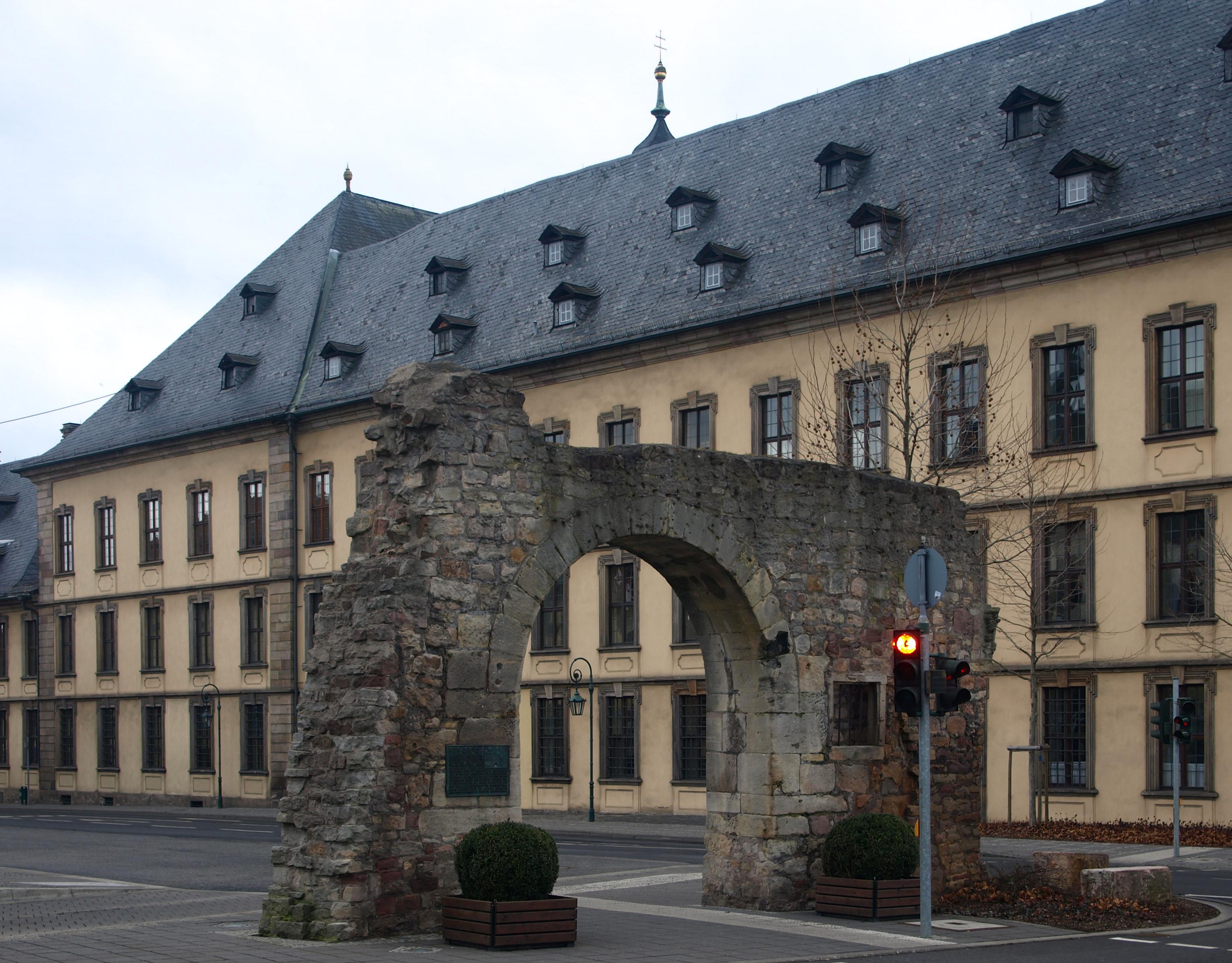
Fulda () (historically in English called Fuld) is a city in Hesse, Germany; it is located on the river Fulda and is the administrative seat of the Fulda district (''Kreis''). In 1990, the city hosted the 30th Hessentag state festival. History Middle Ages In 744 Saint Sturm, a disciple of Saint Boniface, founded the Benedictine monastery of Fulda as one of Boniface's outposts in the reorganization of the church in Germany. The initial grant for the abbey was signed by Carloman, Mayor of the Palace in Austrasia (in office 741ŌĆō47), the son of Charles Martel. The support of the Mayors of the Palace, and later of the early Pippinid and Carolingian rulers, was important to Boniface's success. Fulda also received support from many of the leading families of the Carolingian world. Sturm, whose tenure as abbot lasted from 747 until 779, was most likely related to the Agilolfing dukes of Bavaria. Fulda also received large and constant donations from the Etichonids, a lea ... [...More Info...] [...Related Items...] OR: [Wikipedia] [Google] [Baidu] |


