|
Ingermanland
Ingria is a historical region in what is now northwestern European Russia. It lies along the southeastern shore of the Gulf of Finland, bordered by Lake Ladoga on the Karelian Isthmus in the north and by the River Narva on the border with Estonia in the west. The earliest known indigenous European peoples of the region are the now mostly Eastern Orthodox Izhorians and Votians, as well as the Ingrian Finns who descend from the Lutheran Finnish immigrants who settled in the area in the 17th century, when Finland proper and Ingria were both parts of the Swedish Empire. Ingria as a whole never formed a separate state, however North Ingria was an independent state for just under two years in 1919–1920. The Ingrians, understood as the inhabitants of Ingria regardless of ethnicity, can hardly be said to have been a nation, although the Soviet Union recognized their "nationality"; as an ethnic group, the Ingrians proper, Izhorians, are close to extinction together with their la ... [...More Info...] [...Related Items...] OR: [Wikipedia] [Google] [Baidu] |
Saint Petersburg Governorate
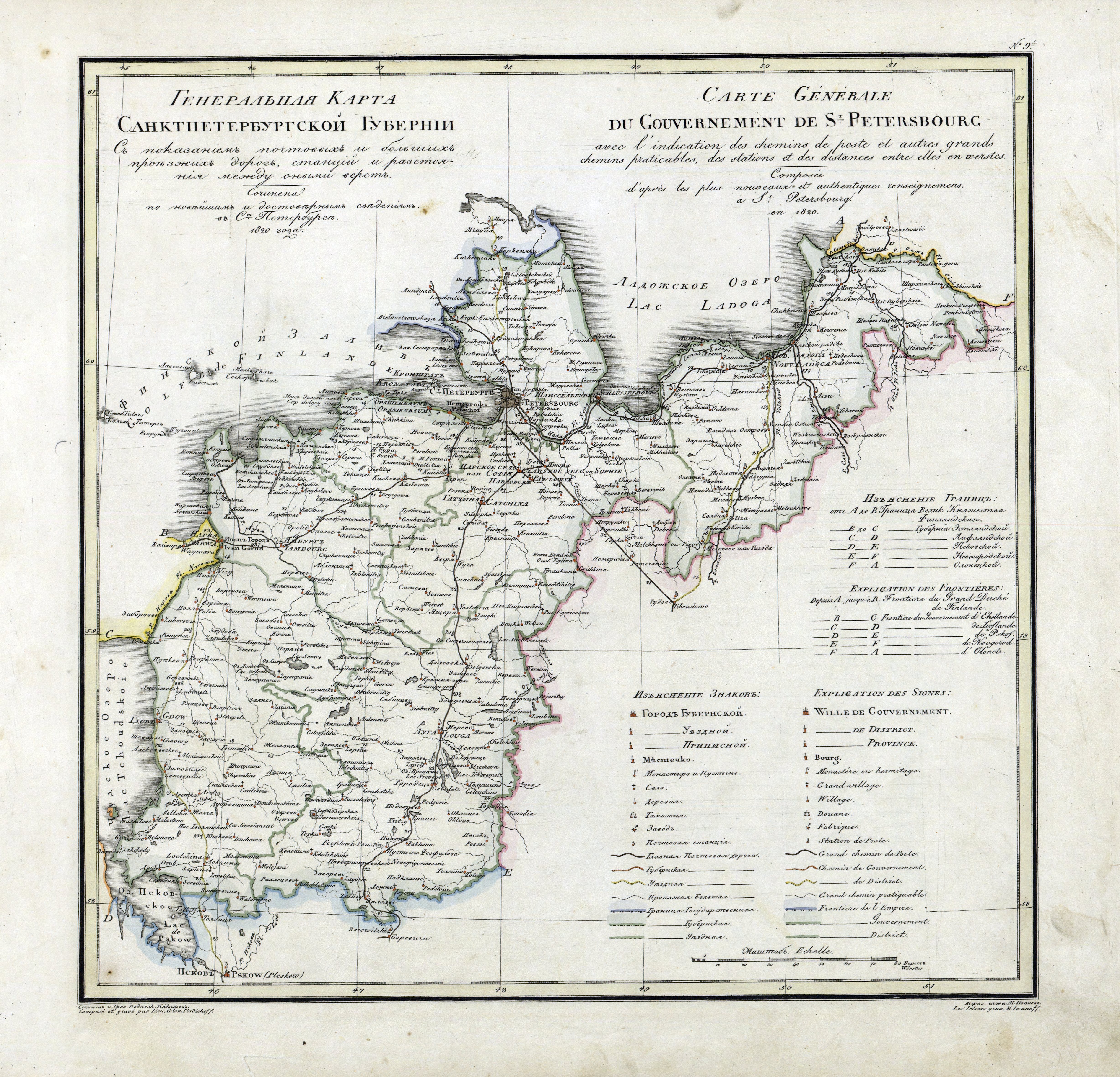
Saint Petersburg Governorate (russian: Санкт-Петербу́ргская губе́рния, ''Sankt-Peterburgskaya guberniya''), or Government of Saint Petersburg, was an administrative division (a '' guberniya'') of the Tsardom of Russia, the Russian Empire, and the Russian SFSR, which existed during 1917–1927. Establishment Ingermanland Governorate (, ''Ingermanlandskaya guberniya'') was created from the territories reconquered from the Swedish Empire in the Great Northern War. In 1704 prince Alexander Menshikov was appointed as its first governor, and in 1706 it was first Russian region designated as a ''Governorate''. According to the Tsar Peter the Great's edict as on , 1708,Указ об учреждении губерний и ... [...More Info...] [...Related Items...] OR: [Wikipedia] [Google] [Baidu] |
North Ingria
The Republic of North Ingria ( fi, Pohjois-Inkerin tasavalta), Ingrian: ''Pohja-inkeriläin respublikka)'' or Republic of Kirjasalo ( fi, Kirjasalon tasavalta, Ingrian: ''Kirjsalon respublikka'') was a short-lived, small state for the Ingrian Finns in the southern part of the Karelian Isthmus, which seceded from Bolshevist Russia after the October Revolution. Its aim by most proponents was to ultimately be incorporated into the Kingdom of Finland, and it ruled parts of Northern Ingria from 1919 until 1920. With the Peace Treaty of Tartu, it was re-integrated into Russia; however, Ingrian Finns of this area enjoyed a certain degree of national autonomy until the 1930s in compliance with the policy of national delimitation in the Soviet Union. In 1928 the Kuivaisi National District was established there with its administrative base in Toksovo. In 1939 it was abolished and the area was joined to the Pargolovo district.Kurs, Ott (1994)Ingria: The broken landbridge between Estonia an ... [...More Info...] [...Related Items...] OR: [Wikipedia] [Google] [Baidu] |
Saint Petersburg
Saint Petersburg ( rus, links=no, Санкт-Петербург, a=Ru-Sankt Peterburg Leningrad Petrograd Piter.ogg, r=Sankt-Peterburg, p=ˈsankt pʲɪtʲɪrˈburk), formerly known as Petrograd (1914–1924) and later Leningrad (1924–1991), is the second-largest city in Russia. It is situated on the Neva River, at the head of the Gulf of Finland on the Baltic Sea, with a population of roughly 5.4 million residents. Saint Petersburg is the fourth-most populous city in Europe after Istanbul, Moscow and London, the most populous city on the Baltic Sea, and the world's northernmost city of more than 1 million residents. As Russia's Imperial capital, and a historically strategic port, it is governed as a federal city. The city was founded by Tsar Peter the Great on 27 May 1703 on the site of a captured Swedish fortress, and was named after apostle Saint Peter. In Russia, Saint Petersburg is historically and culturally associated wi ... [...More Info...] [...Related Items...] OR: [Wikipedia] [Google] [Baidu] |
Ingrian Finns
The Ingrians ( fi, inkeriläiset, ; russian: Ингерманландцы, translit=Ingermanlandts'i), sometimes called Ingrian Finns, are the Finnish population of Ingria (now the central part of Leningrad Oblast in Russia), descending from Lutheran Finnish immigrants introduced into the area in the 17th century, when Finland and Ingria were both parts of the Swedish Empire. In the forced deportations before and after World War II, and during the genocide of Ingrian Finns, most of them were relocated to other parts of the Soviet Union, or killed. Today the Ingrian Finns constitute the largest part of the Finnish population of the Russian Federation. According to some records, some 25,000 Ingrian Finns have returned or still reside in the region of Saint Petersburg. History Origins Finnish-speaking Ingrians are not to be confused with Izhorian-speaking Ingrians. Ingrian Finns mainly consist of two groups: '' Savakot'', who originated from migrant Savonians; and '' Äyrämö ... [...More Info...] [...Related Items...] OR: [Wikipedia] [Google] [Baidu] |
Gatchinsky District
Gatchinsky District (russian: Га́тчинский райо́н) is an administrativeOblast Law #32-oz and municipalLaw #113-oz district (raion), one of the seventeen in Leningrad Oblast, Russia. It is located in the southwestern central part of the oblast and borders with Krasnoselsky, Moskovsky, and Pushkinsky Districts of the federal city of St. Petersburg in the north, Tosnensky District in the east, Luzhsky District in the south, Volosovsky District in the west, and with Lomonosovsky District in the northwest. The area of the district is .Kozhevnikov, p. 61 Its administrative center is the town of Gatchina. Population (excluding the administrative center): 132,010 ( 2002 Census); Geography The northern part of the district is essentially a mixture of urban areas - suburbs of Saint Petersburg - and summer house areas. The central and the southern parts are forested. Much of the area of the district belongs to the drainage basin of the Luga River, a tributa ... [...More Info...] [...Related Items...] OR: [Wikipedia] [Google] [Baidu] |
Kingiseppsky District
Kingiseppsky District (russian: Кингисе́ппский райо́н, fi, Kingiseppin piiri) is an administrativeOblast Law #32-oz and municipalLaw #81-oz district (raion), one of the seventeen in Leningrad Oblast, Russia. It is located in the southwest of the oblast and borders with Ida-Viru County of Estonia in the west, Lomonosovsky District in the northeast, Volosovsky District in the east, and with Slantsevsky District in the south. In the north and northwest it is washed by the waters of the Gulf of Finland. The area of the district is .Official website of Kingiseppsky District Its is the |
Kirovsky District, Leningrad Oblast
Kirovsky District (russian: Ки́ровский райо́н) is an administrativeOblast Law #32-oz and municipalLaw #100-oz district (raion), one of the seventeen in Leningrad Oblast, Russia. It is located in the center of the oblast and borders with Volkhovsky District in the east, Kirishsky District in the southeast, Nevsky and Kolpinsky Districts of the federal city of St. Petersburg in the west, Tosnensky District in the southwest, and with Vsevolozhsky District in the northwest. From the north, the district is bounded by Lake Ladoga. The area of the district is . Its administrative center is the town of Kirovsk. Population (excluding the administrative center): 60,221 ( 2002 Census); Geography The Neva River, which connects Lake Ladoga with the Baltic Sea, serves as the northwestern border of the district. The territory of the district is divided between the drainage basins of the Neva, of Lake Ladoga, and of the Volkhov River, a major tributary of Lake Ladoga ... [...More Info...] [...Related Items...] OR: [Wikipedia] [Google] [Baidu] |
Lomonosovsky District, Leningrad Oblast
Lomonosovsky District (russian: Ломоно́совский райо́н) is an administrativeOblast Law #32-oz and municipalLaw #117-oz district (raion), one of the seventeen in Leningrad Oblast, Russia. It is located in the west of the oblast and borders with Petrodvortsovy and Krasnoselsky Districts of the Federal city of Saint Petersburg in the east, Gatchinsky District in the southeast, Volosovsky District in the south, Kingiseppsky District in the southwest, and the city of oblast significance of Sosnovy Bor in the west. In the north, the district is bounded by the Gulf of Finland. The area of the district is . Its administrative center is the town of Lomonosov (which is not a part of Leningrad Oblast and is located on the territory of the federal city of Saint Petersburg). Population: 65,297 ( 2002 Census); Geography The district is elongated along the shore of the Gulf of Finland and belongs to the drainage basin of the rivers flowing to the gulf, the biggest of w ... [...More Info...] [...Related Items...] OR: [Wikipedia] [Google] [Baidu] |
Tosnensky District
Tosnensky District (russian: То́сненский райо́н) is an administrativeOblast Law #32-oz and municipalLaw #116-oz district (raion), one of the seventeen in Leningrad Oblast, Russia. It is located in the central southwestern part of the oblast and borders with Kirovsky District in the north, Kirishsky District in the east, Chudovsky District of Novgorod Oblast in the southeast, Novgorodsky District of Novgorod Oblast in the south, Luzhsky District in the southwest, Gatchinsky District in the west, and Pushkinsky and Kolpinsky Districts of the federal city of Saint Petersburg in the northwest. The area of the district is . Its administrative center is the town of Tosno. Population (excluding the administrative center): 77,194 ( 2002 Census); Geography The northern part of the district is heavily urbanized and consists essentially of suburbs of Saint Petersburg, whereas the southern part is swampy and hardly populated. The whole area of the district belongs to th ... [...More Info...] [...Related Items...] OR: [Wikipedia] [Google] [Baidu] |
Volosovsky District
Volosovsky District (russian: Во́лосовский райо́н) is an administrativeOblast Law #32-oz and municipalLaw #64-oz district (raion), one of the seventeen in Leningrad Oblast, Russia. It is located in the southwest of the oblast with Lomonosovsky District in the north, Gatchinsky District in the east, Luzhsky District in the south, Slantsevsky District in the southwest, and Kingiseppsky District in the northwest. The area of the district is . Its administrative center is the town of Volosovo. Population: 48,128 ( 2002 Census); The population of Volosovo accounts for 24.6% of the district's total population. Geography The area of the district is basically flat. Much of the area belongs to the drainage basin of the Luga River. The Luga itself forms the southern border of the district. Rivers in the minor areas in the north of the district drain into other tributaries of the Gulf of Finland. The biggest such tributary in the area of the district is the Sista. Hist ... [...More Info...] [...Related Items...] OR: [Wikipedia] [Google] [Baidu] |
Vsevolozhsky District
Vsevolozhsky District (russian: Все́воложский райо́н) is an administrativeOblast Law #32-oz and municipalLaw #17-oz district (raion), one of the seventeen in Leningrad Oblast, Russia. It is located in the central northwestern part of the oblast on the Karelian Isthmus and borders with Priozersky District in the north, Kirovsky District in the south, Vyborgsky District in the northwest, Nevsky, Krasnogvardeysky, Kalininsky, Vyborgsky, and Kurortny Districts of the federal city of St. Petersburg in the west, and is washed by Lake Ladoga in the east. The area of the district is .Official website of Vsevolozhsky DistrictTerritorial Planning of Vsevolozhsky Municipal District of Leningrad Oblast p. 65 Its administrative center is the town of Vsevolozhsk. Population (excluding the administrative center): 131,233 ( 2002 Census); Geography The Okhta River flows through the district while the Neva defines its southeastern border. There are many l ... [...More Info...] [...Related Items...] OR: [Wikipedia] [Google] [Baidu] |
Votians
Votians, also referred to as Votes, Vots and Vods ( vot, Vađđalaizõd, et, vadjalased) are a Finnic ethnic group native to historical Ingria, the part of modern-day northwestern Russia that is roughly southwest of Saint Petersburg and east of the Estonian border-town of Narva. The Finnic Votic language spoken by Votians is close to extinction. The language is still spoken in three villages of historical Votia and by an unknown number of speakers in the countryside. The villages are '' Jõgõperä'' (Krakolye), ''Liivcülä'' (Peski), and ''Luuditsa'' (Luzhitsy).Eesti Rahva Muuseum: Vadjalased Votians were one of the founding people of . History ) , l ...[...More Info...] [...Related Items...] OR: [Wikipedia] [Google] [Baidu] |


