|
December 2013 North American Storm Complex
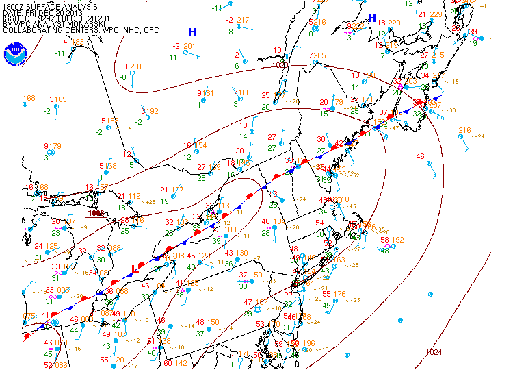
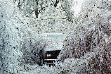
The December 2013 North American storm complex was a significant storm complex that included many different types of severe weather, including a winter storm, a crippling ice storm and a tornado outbreak that impacted the central and eastern portions of Canada, parts of the Central Great Plains, the Southern United States, and the northeastern United States from 20 to 23 December 2013. Formed in the South Central United States, the storm headed across the Great Plains towards Canada into Atlantic Canada and northeastern United States where the storm dissipated on 23 December 2013. The storm produced freezing rain and snow to the affected areas which caused massive damage to electric power transmission and trees. The storm resulted in 29 deaths, loss of power to over a million residents and over $200 million in damages. The storm produced similar conditions to the ice storm of 1998 which affected similar areas. Meteorological history On 19 December, an area of low pressure th ... [...More Info...] [...Related Items...] OR: [Wikipedia] [Google] [Baidu] |
Tornadoes Of 2013
This page documents the tornadoes and tornado outbreaks of 2013. Strong and destructive tornadoes form most frequently in the United States, Bangladesh, Brazil and Eastern India, but they can occur almost anywhere under the right conditions. Tornadoes also appear regularly in neighboring southern Canada during the Northern Hemisphere's summer season, and somewhat regularly in Europe, Asia, and Australia. There were 916 tornadoes confirmed in the United States in 2013. A total of 115 fatalities were confirmed worldwide in 2013: 55 in the United States, 36 in Bangladesh, 24 in China, three in Turkey and two in Brazil. One of these tornadoes was the largest ever at 2.6 miles wide. Despite the high death toll along with several large outbreaks, the year was below average in terms of the number of tornadoes that occurred. On April 1, Canada began utilizing the Enhanced Fujita scale to rate tornadoes with minor modifications to better suit the region's tornadoes. Synopsis E ... [...More Info...] [...Related Items...] OR: [Wikipedia] [Google] [Baidu] |
Ice Storm
An ice storm, also known as a glaze event or a silver storm is a type of winter storm characterized by freezing rain. The U.S. National Weather Service defines an ice storm as a storm which results in the accumulation of at least of ice on exposed surfaces. They are generally not violent storms but instead are commonly perceived as gentle rains occurring at temperatures just below freezing. Formation The formation of ice begins with a layer of above-freezing air above a layer of sub-freezing temperatures closer to the surface. Frozen precipitation melts to rain while falling into the warm air layer, and then begins to refreeze in the cold layer below. If the precipitate refreezes while still in the air, it will land on the ground as sleet. Alternatively, the liquid droplets can continue to fall without freezing, passing through the cold air just above the surface. This thin layer of air then cools the rain to a temperature below freezing (). However, the drops themselves ... [...More Info...] [...Related Items...] OR: [Wikipedia] [Google] [Baidu] |
Electric Power Transmission
Electric power transmission is the bulk movement of electrical energy from a generating site, such as a power plant, to an electrical substation. The interconnected lines that facilitate this movement form a ''transmission network''. This is distinct from the local wiring between high-voltage substations and customers, which is typically referred to as electric power distribution. The combined transmission and distribution network is part of electricity delivery, known as the electrical grid. Efficient long-distance transmission of electric power requires high voltages. This reduces the losses produced by strong currents. Transmission lines use either alternating current (HVAC) or direct current (HVDC). The voltage level is changed with transformers. The voltage is stepped up for transmission, then reduced for local distribution. A wide area synchronous grid, known as an "interconnection" in North America, directly connects generators delivering AC power with the same rel ... [...More Info...] [...Related Items...] OR: [Wikipedia] [Google] [Baidu] |
Snow
Snow comprises individual ice crystals that grow while suspended in the atmosphere—usually within clouds—and then fall, accumulating on the ground where they undergo further changes. It consists of frozen crystalline water throughout its life cycle, starting when, under suitable conditions, the ice crystals form in the atmosphere, increase to millimeter size, precipitate and accumulate on surfaces, then metamorphose in place, and ultimately melt, slide or sublimate away. Snowstorms organize and develop by feeding on sources of atmospheric moisture and cold air. Snowflakes nucleate around particles in the atmosphere by attracting supercooled water droplets, which freeze in hexagonal-shaped crystals. Snowflakes take on a variety of shapes, basic among these are platelets, needles, columns and rime. As snow accumulates into a snowpack, it may blow into drifts. Over time, accumulated snow metamorphoses, by sintering, sublimation and freeze-thaw. Where the climate i ... [...More Info...] [...Related Items...] OR: [Wikipedia] [Google] [Baidu] |
Freezing Rain
Freezing rain is rain maintained at temperatures below freezing by the ambient air mass that causes freezing on contact with surfaces. Unlike a mixture of rain and snow or ice pellets, freezing rain is made entirely of liquid droplets. The raindrops become supercooled while passing through a sub-freezing layer of air hundreds of meters above the ground, and then freeze upon impact with any surface they encounter, including the ground, trees, electrical wires, aircraft, and automobiles. The resulting ice, called glaze ice, can accumulate to a thickness of several centimeters and cover all exposed surfaces. The METAR code for freezing rain is FZRA. A storm that produces a significant thickness of glaze ice from freezing rain is often referred to as an ice storm. Although these storms are not particularly violent, freezing rain is notorious for causing travel problems on roadways, breaking tree limbs, and downing power lines from the weight of accumulating ice. Downed power line ... [...More Info...] [...Related Items...] OR: [Wikipedia] [Google] [Baidu] |
National Oceanic And Atmospheric Administration
The National Oceanic and Atmospheric Administration (abbreviated as NOAA ) is an United States scientific and regulatory agency within the United States Department of Commerce that forecasts weather, monitors oceanic and atmospheric conditions, charts the seas, conducts deep sea exploration, and manages fishing and protection of marine mammals and endangered species in the U.S. exclusive economic zone. Purpose and function NOAA's specific roles include: * ''Supplying Environmental Information Products''. NOAA supplies to its customers and partners information pertaining to the state of the oceans and the atmosphere, such as weather warnings and forecasts via the National Weather Service. NOAA's information services extend as well to climate, ecosystems, and commerce. * ''Providing Environmental Stewardship Services''. NOAA is a steward of U.S. coastal and marine environments. In coordination with federal, state, local, tribal and international authorities, NOAA manages th ... [...More Info...] [...Related Items...] OR: [Wikipedia] [Google] [Baidu] |
Atlantic Canada
Atlantic Canada, also called the Atlantic provinces (french: provinces de l'Atlantique), is the region of Eastern Canada comprising the provinces located on the Atlantic coast, excluding Quebec. The four provinces are New Brunswick, Newfoundland and Labrador, Nova Scotia, and Prince Edward Island. As of 2021, the landmass of the four Atlantic provinces was approximately 488,000 km2, and had a population of over 2.4 million people. The provinces combined had an approximate GDP of $121.888 billion in 2011. The term ''Atlantic Canada'' was popularized following the admission of Newfoundland as a Canadian province in 1949. History The first premier of Newfoundland, Joey Smallwood, coined the term "Atlantic Canada" when Newfoundland joined Canada in 1949. He believed that it would have been presumptuous for Newfoundland to assume that it could include itself within the existing term "Maritime provinces," used to describe the cultural similarities shared by New Brunswick, Princ ... [...More Info...] [...Related Items...] OR: [Wikipedia] [Google] [Baidu] |
South Central United States
The South Central United States or South Central states is a region in the south central portion of the Southern United States. It evolved out of the Old Southwest, which originally was the western portion of the South. The states of Arkansas, Louisiana, Oklahoma, and Texas (which make up what the Census Bureau Division calls West South Central States) are almost always considered the "core" of the region. As part of the East South Central States sub-group of the Census Bureau classification, Alabama, Mississippi, Tennessee and Kentucky are also frequently listed under the heading. At the highest extent, Kansas, and Missouri, may be included by some sources. If defined as only its four core states, the region lies almost exclusively in the Central Time Zone (with El Paso being the only major city to observe Mountain Time). At different times, all of the above states were considered part of the Western United States in American history. History The history of the South Ce ... [...More Info...] [...Related Items...] OR: [Wikipedia] [Google] [Baidu] |
National Post
The ''National Post'' is a Canadian English-language broadsheet newspaper available in several cities in central and western Canada. The paper is the flagship publication of Postmedia Network and is published Mondays through Saturdays, with Monday released as a digital e-edition only.National Post to eliminate Monday print edition , June 19, 2017. Retrieved June 28, 2017 The newspaper is distributed in the provinces of , |
CBC News
CBC News is a division of the Canadian Broadcasting Corporation responsible for the news gathering and production of news programs on the corporation's English-language operations, namely CBC Television, CBC Radio, CBC News Network, and CBC.ca. Founded in 1941, CBC News is the largest news broadcaster in Canada and has local, regional, and national broadcasts and stations. It frequently collaborates with its organizationally separate French-language counterpart, Radio-Canada Info. History The first CBC newscast was a bilingual radio report on November 2, 1936. The CBC News Service was inaugurated during World War II on January 1, 1941, when Dan McArthur, chief news editor, had Wells Ritchie prepare for the announcer Charles Jennings a national report at 8:00 pm. Readers who followed Jennings were Lorne Greene, Frank Herbert and Earl Cameron. ''CBC News Roundup'' (French counterpart: ''La revue de l'actualité'') started on August 16, 1943, at 7:45 pm, being replaced by ... [...More Info...] [...Related Items...] OR: [Wikipedia] [Google] [Baidu] |
Northeastern United States
The Northeastern United States, also referred to as the Northeast, the East Coast, or the American Northeast, is a geographic region of the United States. It is located on the Atlantic coast of North America, with Canada to its north, the Southern United States to its south, and the Midwestern United States to its west. The Northeast is one of the four regions defined by the U.S. Census Bureau for the collection and analysis of statistics. The region is usually defined as including nine U.S. states: Connecticut, Maine, Massachusetts, New Hampshire, New Jersey, New York, Pennsylvania, Rhode Island, and Vermont. The U.S. Census Bureau–defined region of the Northeastern United States has a total area of with of that being land mass, making it the smallest region of the United States by both land mass and total area. The Northeastern region is the nation's most economically developed, densely populated, and culturally diverse region. Of the nation's four census regions, the N ... [...More Info...] [...Related Items...] OR: [Wikipedia] [Google] [Baidu] |
Southern United States
The Southern United States (sometimes Dixie, also referred to as the Southern States, the American South, the Southland, or simply the South) is a geographic and cultural region of the United States of America. It is between the Atlantic Ocean and the Western United States, with the Midwestern and Northeastern United States to its north and the Gulf of Mexico and Mexico to its south. Historically, the South was defined as all states south of the 18th century Mason–Dixon line, the Ohio River, and 36°30′ parallel.The South . ''Britannica.com''. Retrieved June 5, 2021. Within the South are different subregions, such as the |

.png)


