|
Brazil Current
The Brazil Current is a warm water current that flows south along the Brazilian south coast to the mouth of the Río de la Plata. Description This current is caused by diversion of a portion of the Atlantic South Equatorial Current from where that current meets the South American continent. The Brazil Current begins at about 10–15˚S where the South Equatorial Current (SEC) splits near Cabo de São Roque, Brazil. The current reaches a depth of 700 m and the estimated transport at 12˚S is 2.5 Sv. The transport increases as the current goes further south with 4 Sv at 15˚S. On the offshore side of the current an anticyclonic recirculation gyre at about 30˚S causes an increase of the Brazil Current’s transport. The estimated southward transport at 27˚S, 31˚S, 34˚S, and 36˚S are 11 Sv, 17 Sv, 22 Sv, and 41 Sv. The total transport can be from 70 to 80 Sv by 36˚S with half of it being in the recirculation gyre.Zemba, J.C., 1991. "The structure and transport of the B ... [...More Info...] [...Related Items...] OR: [Wikipedia] [Google] [Baidu] |
South Atlantic Gyre
The South Atlantic Gyre is the subtropical gyre in the south Atlantic Ocean. In the southern portion of the gyre, northwesterly (or southeastward-flowing) winds drive eastward-flowing currents that are difficult to distinguish from the northern boundary of the Antarctic Circumpolar Current. Like other oceanic gyres, it collects vast amounts of floating debris as a garbage patch. Southern boundary South of this gyre is the Antarctic Circumpolar Current. This current flows from West to East around Antarctica. Another name for this current is the West Wind Drift. This current allows Antarctica to maintain its huge ice sheet by keeping warm ocean waters away. At approximately 125 Sv, this current is the largest ocean current. Western boundary The Brazil Current is the western boundary current of the gyre. It flows south along the Brazilian coast to the Rio de la Plata. The current is considerably weaker than its North Atlantic counterpart, the Gulf Stream. See also ... [...More Info...] [...Related Items...] OR: [Wikipedia] [Google] [Baidu] |
Brazil
Brazil ( pt, Brasil; ), officially the Federative Republic of Brazil (Portuguese: ), is the largest country in both South America and Latin America. At and with over 217 million people, Brazil is the world's fifth-largest country by area and the seventh most populous. Its capital is Brasília, and its most populous city is São Paulo. The federation is composed of the union of the 26 states and the Federal District. It is the largest country to have Portuguese as an official language and the only one in the Americas; one of the most multicultural and ethnically diverse nations, due to over a century of mass immigration from around the world; and the most populous Roman Catholic-majority country. Bounded by the Atlantic Ocean on the east, Brazil has a coastline of . It borders all other countries and territories in South America except Ecuador and Chile and covers roughly half of the continent's land area. Its Amazon basin includes a vast tropical forest, home to ... [...More Info...] [...Related Items...] OR: [Wikipedia] [Google] [Baidu] |
Río De La Plata
The Río de la Plata (, "river of silver"), also called the River Plate or La Plata River in English, is the estuary formed by the confluence of the Uruguay River and the Paraná River at Punta Gorda. It empties into the Atlantic Ocean and forms a funnel-shaped indentation on the southeastern coastline of South America. Depending on the geographer, the Río de la Plata may be considered a river, an estuary, a gulf, or a marginal sea. If considered a river, it is the widest in the world, with a maximum width of . The river is about long and widens from about at its source to about at its mouth. It forms part of the border between Argentina and Uruguay. The name Río de la Plata is also used to refer to the populations along the estuary, especially the main port cities of Buenos Aires and Montevideo, where Ríoplatense Spanish is spoken and tango culture developed. The coasts of the river are the most densely-populated areas of Uruguay and Argentina. Geography The Río ... [...More Info...] [...Related Items...] OR: [Wikipedia] [Google] [Baidu] |
Atlantic
The Atlantic Ocean is the second-largest of the world's five oceans, with an area of about . It covers approximately 20% of Earth's surface and about 29% of its water surface area. It is known to separate the " Old World" of Africa, Europe and Asia from the " New World" of the Americas in the European perception of the World. The Atlantic Ocean occupies an elongated, S-shaped basin extending longitudinally between Europe and Africa to the east, and North and South America to the west. As one component of the interconnected World Ocean, it is connected in the north to the Arctic Ocean, to the Pacific Ocean in the southwest, the Indian Ocean in the southeast, and the Southern Ocean in the south (other definitions describe the Atlantic as extending southward to Antarctica). The Atlantic Ocean is divided in two parts, by the Equatorial Counter Current, with the North(ern) Atlantic Ocean and the South(ern) Atlantic Ocean split at about 8°N. Scientific explorations of the ... [...More Info...] [...Related Items...] OR: [Wikipedia] [Google] [Baidu] |
South Equatorial Current
The South Equatorial Current are ocean currents in the Pacific, Atlantic, and Indian Ocean that flow east-to-west between the equator and about 20 degrees south. In the Pacific and Atlantic Oceans, it extends across the equator to about 5 degrees north. Within the southern hemisphere, the South Equatorial Current is the westward limb of the very large-scale subtropical gyres. These gyres are driven by the combination of trade winds in the tropics and westerly winds that are found south of about 30 degrees south, through a rather complicated process that includes western boundary current intensification. On the equator, the South Equatorial Current is driven directly by the trade winds which blow from east to west. In the Indian Ocean, the westward-flowing South Equatorial Current is well-developed only south of the equator. Directly on the equator, the winds reverse twice a year due to the monsoons, and so the surface current can be either eastward or westward. See also ... [...More Info...] [...Related Items...] OR: [Wikipedia] [Google] [Baidu] |
South America
South America is a continent entirely in the Western Hemisphere and mostly in the Southern Hemisphere, with a relatively small portion in the Northern Hemisphere at the northern tip of the continent. It can also be described as the southern subregion of a single continent called America. South America is bordered on the west by the Pacific Ocean and on the north and east by the Atlantic Ocean; North America and the Caribbean Sea lie to the northwest. The continent generally includes twelve sovereign states: Argentina, Bolivia, Brazil, Chile, Colombia, Ecuador, Guyana, Paraguay, Peru, Suriname, Uruguay, and Venezuela; two dependent territories: the Falkland Islands and South Georgia and the South Sandwich Islands; and one internal territory: French Guiana. In addition, the ABC islands of the Kingdom of the Netherlands, Ascension Island (dependency of Saint Helena, Ascension and Tristan da Cunha, a British Overseas Territory), Bouvet Island ( dependency ... [...More Info...] [...Related Items...] OR: [Wikipedia] [Google] [Baidu] |
Gyre
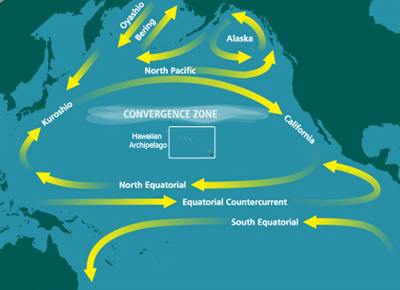
In oceanography, a gyre () is any large system of circulating ocean currents, particularly those involved with large wind movements. Gyres are caused by the Coriolis effect; planetary vorticity, horizontal friction and vertical friction determine the circulatory patterns from the ''wind stress curl'' ( torque). ''Gyre'' can refer to any type of vortex in an atmosphere or a sea, even one that is human-created, but it is most commonly used in terrestrial oceanography to refer to the major ocean systems. Major gyres The following are the five most notable ocean gyres:The five most notable gyres PowerPoint Presentation * |
Western Boundary Current
Boundary currents are ocean currents with dynamics determined by the presence of a coastline, and fall into two distinct categories: western boundary currents and eastern boundary currents. Eastern boundary currents Eastern boundary currents are relatively shallow, broad and slow-flowing. They are found on the eastern side of oceanic basins (adjacent to the western coasts of continents). Subtropical eastern boundary currents flow equatorward, transporting cold water from higher latitudes to lower latitudes; examples include the Benguela Current, the Canary Current, the Humboldt (Peru) Current, and the California Current. Coastal upwelling often brings nutrient-rich water into eastern boundary current regions, making them productive areas of the ocean. Western boundary currents Western boundary currents may themselves be divided into sub-tropical or low-latitude western boundary currents. Sub-tropical western boundary currents are warm, deep, narrow, and fast-flowing currents t ... [...More Info...] [...Related Items...] OR: [Wikipedia] [Google] [Baidu] |
Gulf Stream
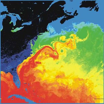
The Gulf Stream, together with its northern extension the North Atlantic Drift, is a warm and swift Atlantic ocean current that originates in the Gulf of Mexico and flows through the Straits of Florida and up the eastern coastline of the United States then veers east near 36 latitude (North Carolina) and moves toward Northwest Europe as the North Atlantic Current. The process of western intensification causes the Gulf Stream to be a northwards accelerating current off the east coast of North America. At about , it splits in two, with the northern stream, the North Atlantic Drift, crossing to Northern Europe and the southern stream, the Canary Current, recirculating off West Africa. The Gulf Stream influences the climate of the coastal areas of the east coast of the United States from Florida to southeast Virginia (near 36 north latitude), and to a greater degree the climate of Northwest Europe. There is consensus that the climate of northwest Europe is warmer than other ar ... [...More Info...] [...Related Items...] OR: [Wikipedia] [Google] [Baidu] |
Falkland Current
The Falkland Current (also called Malvinas Current or Falklands Current) is a cold water current that flows northward along the Atlantic coast of Patagonia as far north as the mouth of the Río de la Plata. This current results from the movement of water from the West Wind Drift as it rounds Cape Horn. It takes its name from the Falkland Islands ( es, Islas Malvinas). This cold current mixes with the tropical Brazil Current in the Argentine Sea (see Brazil–Falkland Confluence), giving it its temperate climate.Ecorregión Mar Argentino The current is an equatorward flowing current that carries cold and relatively fresh water. The Falkland Current is a branch of the |
Argentine Sea
The Argentine Sea ( es, Mar Argentino) is a marginal sea of the Atlantic Ocean adjacent to the southern tip of South America. It ranges from the mouth of the estuary of the Río de la Plata in the north (35th parallel south) to the Isla de los Estados in the south, and from the Argentine coast to the 200 meters isobath. Its width varies between 210 km in front of Mar del Plata and 850 km at the latitude of the Falkland Islands. The coastline extends for 4,725 km. To the east of the Argentine Sea extends much deeper and more extensive Argentine Basin. Geography The Argentine Sea is in the South Atlantic Ocean off the southeastern coast of Argentina, extending from the approximate latitude of Montevideo, Uruguay, southward to Tierra del Fuego, and is situated about north of Antarctica. The Argentine Sea has a surface area of and is one of the largest seas in the world. The average depth of the sea is and the maximum depth is . It has a salinity of 3.5%. The A ... [...More Info...] [...Related Items...] OR: [Wikipedia] [Google] [Baidu] |
Brazil–Falkland Confluence
The Brazil–Falkland Confluence Zone (also called the Brazil–Falklands Confluence Zone or the Brazil–Malvinas Confluence Zone) is a very energetic region of water just off the coast of Argentina and Uruguay where the warm poleward flowing Brazil Current and the cold equatorward flowing Falkland Current converge. The region oscillates latitudinally, but in general the region of confluence occurs between 35 and 45 degrees south latitude and 50 to 70 degrees west longitude. The confluence of these two currents causes a strong thermohaline to exist and causes numerous high energy eddies to form.Maamaatuaiahutapu, K. et al.(1998)., Transports of the Brazil and Malvinas Currents at their Confluence. Journal of Marine Research Vol. 56 Issue 2, p417 Brazil Current The Brazil Current is a poleward flowing current that carries warm subtropical water. The Brazil Current branches off northward from the South Equatorial Current at around 10 degrees South. As it flows poleward it b ... [...More Info...] [...Related Items...] OR: [Wikipedia] [Google] [Baidu] |


