|
Östhammar Municipality
Östhammar Municipality (''Östhammars kommun'') is a municipality in Uppsala County in east central Sweden. Its seat is located in the city of Östhammar. The present municipality was created during the local government reform in the late sixties and early seventies. Already in 1967 the City of Öregrund joined the City of Östhammar in a common municipality. It was the first time a former city joined another local government unit. By 1971 the new combined city became a municipality of unitary type and in 1974 more units were added. In June 2018 the municipal council voted in favour of the building of Forsmark nuclear waste repository, with the final decision needing to be made by the Swedish government. Localities All towns with over 200 inhabitants in 2000, from Statistics Sweden. *Östhammar (seat) * Gimo *Österbybruk *Hargshamn * Dannemora *Öregrund *Alunda * Skoby (part of this bimunicipalocality is in Uppsala Municipality) * Norrskedika Another notable village is Fors ... [...More Info...] [...Related Items...] OR: [Wikipedia] [Google] [Baidu] |
Municipalities Of Sweden
The municipalities of Sweden ( sv, Sveriges kommuner) are its lower-level local government entities. There are 290 municipalities which are responsible for a large proportion of local services, including schools, emergency services and physical planning. Foundation The Local Government Act of 1991 specifies several responsibilities for the municipalities, and provides outlines for local government, such as the process for electing the municipal assembly. It also regulates a process (''laglighetsprövning'', "legality trial") through which any citizen can appeal the decisions of a local government to a county court. Municipal government in Sweden is similar to city commission government and cabinet-style council government. A legislative municipal assembly ''( kommunfullmäktige)'' of between 31 and 101 members (always an odd number) is elected from party-list proportional representation at municipal elections, held every four years in conjunction with the national general e ... [...More Info...] [...Related Items...] OR: [Wikipedia] [Google] [Baidu] |
Gimo, Sweden
Gimo () is a Urban areas in Sweden, small town situated in Östhammar Municipality, Uppsala County, Sweden with 2,765 inhabitants in 2017. The town is located about 20 km west of the Baltic Sea coast and 50 km north of Uppsala. Gimo is best known for the production plant of Sandvik Coromant with 1,500 employees (2019). History Little is known about the early history of Gimo. A rune stone from the 10th century is located near the reservoir Gimo Damm. The first mention of the place was in the years 1375–1376 when it was described as the village "Gimmu". The church in Gimo is called "Skäfthammar kyrka" and was probably built in the late 15th century. The ironworks of the area has a thousand year long history. No one knows exactly when the ironworks of Gimo was founded, but the first written records are from 1615 when Hans Sifversson built iron works on behalf of the crown. Louis De Geer (1587–1652), Louis De Geer bought the iron works in 1643 and expanded the business. ... [...More Info...] [...Related Items...] OR: [Wikipedia] [Google] [Baidu] |
Norrtälje Municipality
Norrtälje Municipality (''Norrtälje kommun'') is a municipality in Stockholm County in east central Sweden. Its seat is located in the city of Norrtälje. It is the largest and northernmost municipality of Stockholm County and was created in 1971 through the amalgamation of several former municipalities. There are 25 original local government units (as of 1863) combined in the present municipality. Many of the houses in Norrtälje municipality are summer cottages, only inhabited during summertime. This is due to its geographical location by the Stockholm archipelago, which makes it popular among Stockholmers and tourists. Localities Elections Riksdag This table lists the national results since the 1972 Swedish municipality reform. The results of the Sweden Democrats from 1988 to 1998 were not published by the SCB at a municipal level due to the party's small size nationally at the time. Blocs This lists the relative strength of the socialist and centre-right blocs si ... [...More Info...] [...Related Items...] OR: [Wikipedia] [Google] [Baidu] |
Eckerö
Eckerö is a municipality of Åland, an autonomous territory under Finnish sovereignty. The municipality has a population of () and covers an area of of which is water. The population density is . The municipality is unilingually Swedish and of the population are Swedish speakers. It is the westernmost municipality of Åland and Finland. The company Eckerö Linjen operates a ferry connection between Berghamn in Storby, Eckerö and Grisslehamn on Väddö, Norrtälje in Sweden Sweden, formally the Kingdom of Sweden,The United Nations Group of Experts on Geographical Names states that the country's formal name is the Kingdom of SwedenUNGEGN World Geographical Names, Sweden./ref> is a Nordic country located on .... The municipality has previously also been known as ''Ekkerö'' in Finnish documents, but is today referred to as "Eckerö" also in Finnish. Eckerö's most famous building is the Post and Customs house. It is the largest building that has been erect ... [...More Info...] [...Related Items...] OR: [Wikipedia] [Google] [Baidu] |
Sea Of Åland
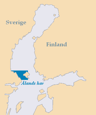
The Åland Sea (or the Sea of Åland; sv, Ålands hav, fi, Ahvenanmeri) is a waterway in the southern Gulf of Bothnia, between Åland and Sweden. It connects the Bothnian Sea with the Baltic Sea proper. The western part of the basin is in Swedish territorial waters while the eastern part is in Finnish territorial waters. The Åland Sea has two sub-basins. The main basin is the Åland Sea proper, also called the northern Åland Sea basin. In the south, there is the smaller Lågskär Deep, also called the Lågskär Basin or the southern Åland Sea basin. The narrowest part on the northern edge of the basin is named the Southern Quark or South Kvarken ( sv, Södra Kvarken, fi, Ahvenanrauma). The trench running on the bottom of the Sea of Åland contains the second-deepest spot of the Baltic Sea, at a depth of 301 meters, which is second only to Landsort Deep. The mean depth of Åland Sea is 75 m, area 5,477 km2 and its volume is 411 km³. The Archipelago Sea The A ... [...More Info...] [...Related Items...] OR: [Wikipedia] [Google] [Baidu] |
Bothnian Sea
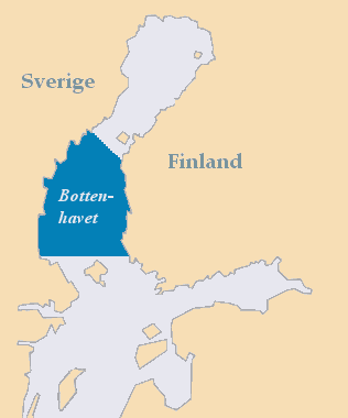
The Bothnian Sea ( sv, Bottenhavet; fi, Selkämeri) links the Bothnian Bay (also called the Bay of Bothnia) with the Baltic proper. Kvarken is situated between the two. Together, the Bothnian Sea and Bay make up a larger geographical entity, the Gulf of Bothnia, where the Bothnian Sea is the southern part. The whole Gulf of Bothnia is situated between Sweden, to the west, Finland, to the east, and the Sea of Åland and Archipelago Sea to the south. The surface area of the Bothnian Sea is approximately 79,000 km². The largest coastal towns, from south to north, are Rauma and Pori in Finland, and Gävle and Sundsvall in Sweden. Umeå (Sweden) and Vaasa (Finland) lie in the extreme north, near Bothnian Bay. See also * Bothnian Sea National Park References External links * {{Marginal seas of the Atlantic Ocean Baltic Sea Gulfs of Sweden Bodies of water of Finland Bothnia The Gulf of Bothnia (; fi, Pohjanlahti; sv, Bottniska viken) is divided into ... [...More Info...] [...Related Items...] OR: [Wikipedia] [Google] [Baidu] |
Humid Continental Climate
A humid continental climate is a climatic region defined by Russo-German climatologist Wladimir Köppen in 1900, typified by four distinct seasons and large seasonal temperature differences, with warm to hot (and often humid) summers and freezing cold (sometimes severely cold in the northern areas) winters. Precipitation is usually distributed throughout the year but often do have dry seasons. The definition of this climate regarding temperature is as follows: the mean temperature of the coldest month must be below or depending on the isotherm, and there must be at least four months whose mean temperatures are at or above . In addition, the location in question must not be semi-arid or arid. The cooler ''Dfb'', ''Dwb'', and ''Dsb'' subtypes are also known as hemiboreal climates. Humid continental climates are generally found between latitudes 30° N and 60° N, within the central and northeastern portions of North America, Europe, and Asia. They are rare and ... [...More Info...] [...Related Items...] OR: [Wikipedia] [Google] [Baidu] |
Forsmark
Forsmark is a village with 59 inhabitants on the east coast of Uppland, Sweden. It is best known as the location of the Forsmark Nuclear Power Plant. Another noteworthy facility in Forsmark is the static inverter of HVDC Fenno-Skan, just west of the nuclear power plant. Because of the sensitive instruments for detecting local leaks of radioactivity, the nuclear power plant was the first place outside the Soviet Union where signs of the Chernobyl accident were detected on April 27, 1986. When workers at the plant were found to carry radioactive particles, the origin of the leak was investigated and it eventually became clear that the contamination came from the atmosphere rather than from the Forsmark plant itself. History Forsmark formerly had an ironworks producing oregrounds iron Oregrounds iron was a grade of iron that was regarded as the best grade available in 18th century England. The term was derived from the small Swedish city of Öregrund, the port from which the ... [...More Info...] [...Related Items...] OR: [Wikipedia] [Google] [Baidu] |
Norrskedika
Norrskedika is a locality situated in Östhammar Municipality, Uppsala County, Sweden Sweden, formally the Kingdom of Sweden,The United Nations Group of Experts on Geographical Names states that the country's formal name is the Kingdom of SwedenUNGEGN World Geographical Names, Sweden./ref> is a Nordic countries, Nordic c ... with 214 inhabitants in 2010. References Populated places in Uppsala County Populated places in Östhammar Municipality {{Uppsala-geo-stub ... [...More Info...] [...Related Items...] OR: [Wikipedia] [Google] [Baidu] |
Uppsala Municipality
Uppsala Municipality (''Uppsala kommun'') is a municipality in Uppsala County in east central Sweden. Uppsala has a population of 211,411 (2016-06-30). Its seat is located in the university city of Uppsala. Uppsala Municipality was created through amalgamations taking place during the late sixties and the early seventies. There are about thirty original local government units combined in the present municipality. A split took place in 2003, when Knivsta Municipality was formed. Towns and villages By population: * Uppsala (seat) * Sävja * Storvreta * Björklinge * Bälinge * Vattholma * Vänge * Lövstalöt * Almunge * Länna * Skyttorp * Ytternäs och Vreta * Knutby * Gåvsta * Järlåsa * Gunsta * Skölsta * Ramstalund * Håga * Vårdsätra * Skoby * Läby * Blackstalund Economy Largest operating companies in Uppsala: * Erasteel, metallurgy * Cytiva, biotechnology * Upplands Motor, car dealership * Beijer Alma, technology * Frese ... [...More Info...] [...Related Items...] OR: [Wikipedia] [Google] [Baidu] |
Skoby
Skoby is a bimunicipal locality situated in Östhammar Municipality and Uppsala Municipality in Uppsala County, Sweden Sweden, formally the Kingdom of Sweden,The United Nations Group of Experts on Geographical Names states that the country's formal name is the Kingdom of SwedenUNGEGN World Geographical Names, Sweden./ref> is a Nordic countries, Nordic c ... with 230 inhabitants in 2010. References Populated places in Uppsala County Populated places in Östhammar Municipality Populated places in Uppsala Municipality {{Uppsala-geo-stub ... [...More Info...] [...Related Items...] OR: [Wikipedia] [Google] [Baidu] |
Alunda
Alunda is a locality situated in Östhammar Municipality, Uppsala County, Sweden Sweden, formally the Kingdom of Sweden,The United Nations Group of Experts on Geographical Names states that the country's formal name is the Kingdom of SwedenUNGEGN World Geographical Names, Sweden./ref> is a Nordic country located on ... with 2,317 inhabitants in 2010. References Populated places in Uppsala County Populated places in Östhammar Municipality {{Uppsala-geo-stub ... [...More Info...] [...Related Items...] OR: [Wikipedia] [Google] [Baidu] |


