|
Yarmuk (river)
The Yarmuk River (, ; Ancient Greek, Greek: Ἱερομύκης, ; or ''Heromicas''; sometimes spelled Yarmouk) is the largest tributary of the Jordan River. It runs in Jordan, Syria and Israel, and drains much of the Hauran plateau. Its main tributaries are the wadis of Nahr al-Allan, 'Allan and Ruqqad from the north, Ehreir and Zeizun from the east. Although the Yarmuk is narrow and shallow throughout its course, at its mouth it is nearly as wide as the Jordan, measuring thirty feet in breadth and five in depth. History Yarmuk forms a natural border between the plains to the north - Hauran, Bashan and Golan Heights, Golan - and the Gilead mountains to the south. Thus it has often served as boundary line between political entities. Neolithic The Yarmukian Culture, Yarmukian is a Pottery Neolithic culture that inhabited parts of Israel and Jordan. Its type site is at Sha'ar HaGolan (archaeological site), Sha'ar HaGolan, on the river mouth. Bronze Age Early Bronze Age I is re ... [...More Info...] [...Related Items...] OR: [Wikipedia] [Google] [Baidu] |
Hauran
The Hauran (; also spelled ''Hawran'' or ''Houran'') is a region that spans parts of southern Syria and northern Jordan. It is bound in the north by the Ghouta oasis, to the northeast by the al-Safa field, to the east and south by the Harrat al-Sham and to the west by the Golan Heights. Traditionally, the Hauran consists of three subregions: the Nuqrah and Jaydur plains, the Jabal al-Druze massif, and the Lajat volcanic field. The population of the Hauran is largely Arab, but religiously heterogeneous; most inhabitants of the plains are Sunni Muslims belonging to large agrarian clans, while Druze form the majority in the eponymous Jabal al-Druze and a significant Greek Orthodox and Greek Catholic minority inhabit the western foothills of Jabal al-Druze. The region's largest towns are Daraa, al-Ramtha, and al-Suwayda. From the mid-1st century BC, the region was governed by the Roman Empire's Herodian and Nabatean client kings until it was formally annexed by the empire in ... [...More Info...] [...Related Items...] OR: [Wikipedia] [Google] [Baidu] |
Bashan
Bashan (; ; or ''Basanitis'') is the ancient, biblical name used for the northernmost region of Transjordan during the Iron Age. It is situated in modern-day Jordan and Syria. Its western part, nowadays known as the Golan Heights, was occupied by Israel during the 1967 Six Day War. Bashan has been inhabited since at least the fourth millennium BCE. Its earliest mention is found in a Sumerian text dating back to the third millennium BCE. During the Late Bronze Age, Bashan is recorded in Egyptian sources as being under the control of their empire. Biblical tradition holds that an Amorite kingdom in Bashan was conquered by the Israelites during the reign of King Og. Throughout the monarchic period, Bashan was contested between the kingdoms of Israel and Aram-Damascus. Tiglath-pileser III of Assyria eventually intervened, removing Bashan from Israel's control. Bashan is mentioned 59 times in the Hebrew Bible. It is the location of Ashtaroth Karnaim and Edrei (modern-day Daraa) ... [...More Info...] [...Related Items...] OR: [Wikipedia] [Google] [Baidu] |
Jalin
Jalin (, also spelled Jileen or Jillin) is a village in southern Syria, administratively part of the Daraa Governorate, located northwest of Daraa. Nearby localities include Muzayrib to the southeast, Tafas to the east, al-Shaykh Saad to the northeast, Adwan to the north, Tasil to the northwest and Saham al-Jawlan and Hit to the west. According to the Syria Central Bureau of Statistics, Jalin had a population of 4,337 in the 2004 census.General Census of Population and Housing 2004 Syria Central Bureau of Statistics (CBS). Daraa Governorate. History In some sources re ...[...More Info...] [...Related Items...] OR: [Wikipedia] [Google] [Baidu] |
Hit, Daraa Governorate
Hit (; also transliterated ''Heit'' or ''Hayt'') is a village in southern Syria, administratively part of the Daraa Governorate. According to the Syrian Central Bureau of Statistics, it had a population of 3,956 in the 2004 census. The village sits by the confluence of the Allan and Ehreir streams, overlooking the deep gorge where the streams meet. It is near the approaches to the Yarmuk river, which represents the border between Syria and Jordan. History Ottoman period In 1596 Hit appeared in the Ottoman tax registers as part of the ''nahiya'' (subdistrict) of Jawlan Sharqi in the Qada of Hauran. It had an all Muslim population consisting of 20 households and 15 bachelors. A fixed tax−rate of 25% was paid on wheat (6,000 akçe), barley (2,250 a.), summer crops (750 a.), goats and/or beehives (1,000), in addition to taxes on a water mill (120 a.) and occasional revenues (880 a.); a total of 11,000 akçe. In 1886, Gottlieb Schumacher noted that Hit was a medium-sized villa ... [...More Info...] [...Related Items...] OR: [Wikipedia] [Google] [Baidu] |
Dara'a
Daraa (, Levantine Arabic: ) is a city in southwestern Syria, north of the border with Jordan. It is the capital of Daraa Governorate in the Hauran region. Located south of Damascus on the Damascus–Amman highway, it serves as a way station for travelers. Nearby localities include Umm al-Mayazen and Nasib to the southeast, al-Naimah to the east, Ataman to the north, al-Yaduda to the northwest and Ramtha, Jordan, to the southwest. According to the Syrian Central Bureau of Statistics, Daraa had a population of 97,969 in the 2004 census. It is the administrative center of a ''nahiya'' (subdistrict) which contained eight localities with a collective population of 146,481 in 2004. By the 3rd century, it had gained the status of polis or self-governed city. The Roman historian Eusebius referred to it. The area east of Adraa was a centre of the Ebionites. Adraa itself was a Christian bishopric. Arabio, the first bishop of Adraa whose name is known, participated in the Coun ... [...More Info...] [...Related Items...] OR: [Wikipedia] [Google] [Baidu] |
Geshur
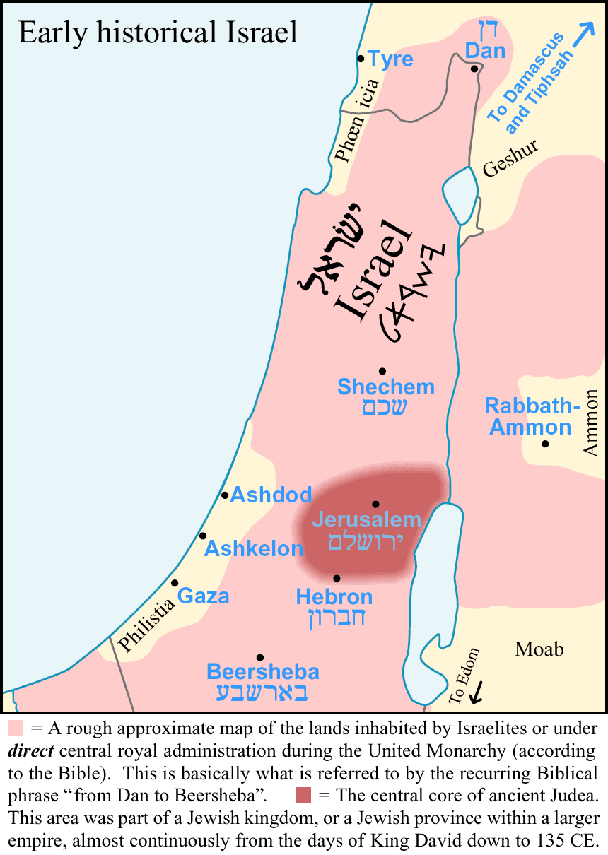
Geshur () was a territory in the ancient Levant mentioned in the early books of the Hebrew Bible and possibly in several other ancient sources, located in the region of the modern-day Golan Heights. Some scholars suggest it was established as an independent city-state during the early Iron Age from the middle of the tenth century BCE, maintaining its autonomy for about a century until it was annexed in the third quarter of the eighth century by Tiglath-Pileser III, the king of Assyria. Location Geshur is identified with the area stretching along the eastern shore of the Sea of Galilee and reaching south to the Yarmuk River, in what is now called the Golan Heights. This location places it on one of the routes connecting the region of Bashan with the Phoenician coast. Tel Dover, located southeast of the Sea of Galilee on the Jarmuk (Yarmuk) River, may have been the kingdom's southern border. Surveys conducted within the Golan Heights have not discovered many settlements within ... [...More Info...] [...Related Items...] OR: [Wikipedia] [Google] [Baidu] |
Early Bronze Age
The Bronze Age () was a historical period characterised principally by the use of bronze tools and the development of complex urban societies, as well as the adoption of writing in some areas. The Bronze Age is the middle principal period of the three-age system, following the Stone Age and preceding the Iron Age. Conceived as a global era, the Bronze Age follows the Neolithic, with a transition period between the two known as the Chalcolithic. The final decades of the Bronze Age in the Mediterranean basin are often characterised as a period of widespread societal collapse known as the Late Bronze Age collapse (), although its severity and scope are debated among scholars. An ancient civilisation is deemed to be part of the Bronze Age if it either produced bronze by smelting its own copper and alloying it with tin, arsenic, or other metals, or traded other items for bronze from producing areas elsewhere. Bronze Age cultures were the first to History of writing, develop writin ... [...More Info...] [...Related Items...] OR: [Wikipedia] [Google] [Baidu] |
Sha'ar HaGolan (archaeological Site)
Sha'ar HaGolan is a Neolithic archaeological site near Kibbutz Sha'ar HaGolan in Israel. The type site of the Yarmukian culture, it is notable for the discovery of a significant number of artistic objects, as well as some of the earliest pottery in the Southern Levant. The first Yarmukian settlement was unearthed at Tel Megiddo during the 1930s, but was not identified as a distinct Neolithic culture at the time. At Sha'ar HaGolan, in 1949, professor Moshe Stekelis first identified the Yarmukian culture, a Pottery Neolithic culture that inhabited parts of Israel and Jordan.Garfinkel Y. 1993. The site, dated to ca. 6400–6000 BC (calibrated), is located in the central Jordan Valley, on the northern bank of the Yarmouk River. Its size is around 20 hectares, making it one of the largest settlements in the world at that time. Although other Yarmukian sites have been identified since, Sha'ar HaGolan is the largest, probably indicating its role as the Yarmukian center.Garfinkel, Y. 19 ... [...More Info...] [...Related Items...] OR: [Wikipedia] [Google] [Baidu] |
Type Site
In archaeology, a type site (American English) or type-site (British English) is the site used to define a particular archaeological culture or other typological unit, which is often named after it. For example, discoveries at La Tène and Hallstatt led scholars to divide the European Iron Age into the La Tène culture and Hallstatt culture, named after their respective type sites. The concept is similar to type localities in geology and type specimens in biology. Notable type sites Africa * Nok ( Kaduna, Nigeria), of the Nok culture East Asia * Banpo ( Yangshao culture, Neolithic Yangshao culture, China) * Liangzhu Town, near Hangzhou ( Liangzhu culture, Neolithic, China) * Songguk-ri (Middle Mumun culture, southern Korea) * Suemura cluster of kilns – Kilns of Sue pottery (Middle and Late Kofun period, Osaka, Japan) * Sanage cluster of kilns — Kilns of and ( Nara and Heian period, Aichi Prefecture, Japan) Europe *a river terrace of the River Som ... [...More Info...] [...Related Items...] OR: [Wikipedia] [Google] [Baidu] |
Yarmukian Culture
The Yarmukian culture was a Pottery Neolithic A (PNA) culture of the ancient Levant. It was the first culture in prehistoric Syria and one of the oldest in the Levant to make use of pottery. The Yarmukian derives its name from the Yarmuk River, which flows near its type site of Sha'ar Hagolan at the foot of the Golan Heights. This culture existed alongside the Lodian, or Jericho IX culture and the Nizzanim culture to the south. Recent theory In 2015, a salvage excavation brought to light a prehistoric site near Beit Hilkia and the Revivim quarry, with findings from the Yarmukian, Late Chalcolithic, and the Middle Bronze Age IIA–IIB. Somewhat surprising was the discovery of a typical Yarmukian-style fired clay figurine of a fertility goddess, the southernmost such finding. Of 163 sites found up to that date, the vast majority had been discovered in the main area known for its Yarmukian settlements, in and around the northern type-site of Sha'ar Hagolan, with just tw ... [...More Info...] [...Related Items...] OR: [Wikipedia] [Google] [Baidu] |


