|
Wadi Ghazzeh
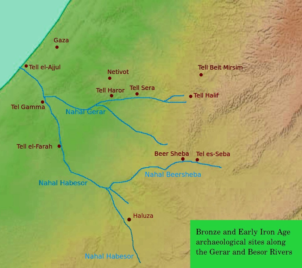
The Besor ( he, נחל הבשור, ''Nahal HaBesor'') is a wadi in southern Israel. The stream begins at Mount Boker (near Sde Boker), and spills into the Mediterranean Sea near Al-Zahra in the Gaza Strip, where it is called Wadi Gaza ( ar, وادي غزة, Wadi Ghazzeh), also spelled Wadi Ghazza or Wadi 'Azza. Further upstream it is marked as Wadi esh-Shallaleh on the 1878 Survey of Western Palestine map. There are several important archaeological sites located in this area. The stream is the largest in the northern Negev, and together with its largest tributaries, the Nahal Gerar, and the Beersheba stream, reaches as far east into the desert as Sde Boker, Yeruham, Dimona and Arad/Tel Arad. The Gaza section of the Coastal Aquifer is the only significant source of water in the Gaza Strip. The Wadi Gaza runs through a wetland, the Gaza Valley, and as of 2012 it is used as a wastewater dump. History In the Old Testament Besor was a ravine or brook in the extreme south-west of J ... [...More Info...] [...Related Items...] OR: [Wikipedia] [Google] [Baidu] |
Gerar
Gerar ( ''Gərār'', "lodging-place") was a Philistine town and district in what is today south central Israel, mentioned in the Book of Genesis and in the Second Book of Chronicles of the Hebrew Bible. Identification According to the International Standard Bible Encyclopedia, the biblical ''valley of Gerar'' () was probably located in the area of a valley known in Arabic as Wady Sheri'a, and in Modern Hebrew as Nahal Gerar. Most commentators see the mound of Tel Haror (Hebrew) or Tell Abu Hureyra (Arabic) as representing the ancient Gerar. Some older commentaries, such as Smith's Bible Dictionary, stated simply that Gerar was located "south of Gaza". Also, a ninth century rabbinical source (Saadia Gaon) identified Gerar with Haluza, located along the Besor River in the Negev.Rabbi Saadia Gaon's Judeo-Arabic Translation of the word Gerar (Judeo-Arabic: אלכ'לוץ = ''al-Khalūṣ'') in the Pentateuch (''Tafsir''), s.v. Genesis 10:19, Genesis 20:2, Genesis 26:17, 20. On H ... [...More Info...] [...Related Items...] OR: [Wikipedia] [Google] [Baidu] |
Amalekites
Amalek (; he, עֲמָלֵק, , ar, عماليق ) was a nation described in the Hebrew Bible as a staunch enemy of the Israelites. The name "Amalek" can refer to the nation's founder, a grandson of Esau; his descendants, the Amalekites; or the territories of Amalek, which they inhabited. Etymology In some rabbinical interpretations, Amalek is etymologised as , 'a people who lick (blood)', but most specialists regard the origin to be unknown. Amalekites in the Hebrew Bible According to the Bible, Amalek was the son of Eliphaz (himself the son of Esau, ancestor of the Edomites) and Eliphaz's concubine Timna. Timna was a Horite and sister of Lotan. Amalek is described as the "chief of Amalek" among the "chiefs of the sons of Esau", from which it is surmised that he ruled a clan or territory named after him. The Amalekites () were considered to be Amalek's descendants through the genealogy of Esau. In the oracle of Balaam, Amalek was called the 'first of the nations'. One mod ... [...More Info...] [...Related Items...] OR: [Wikipedia] [Google] [Baidu] |
Epipaleolithic
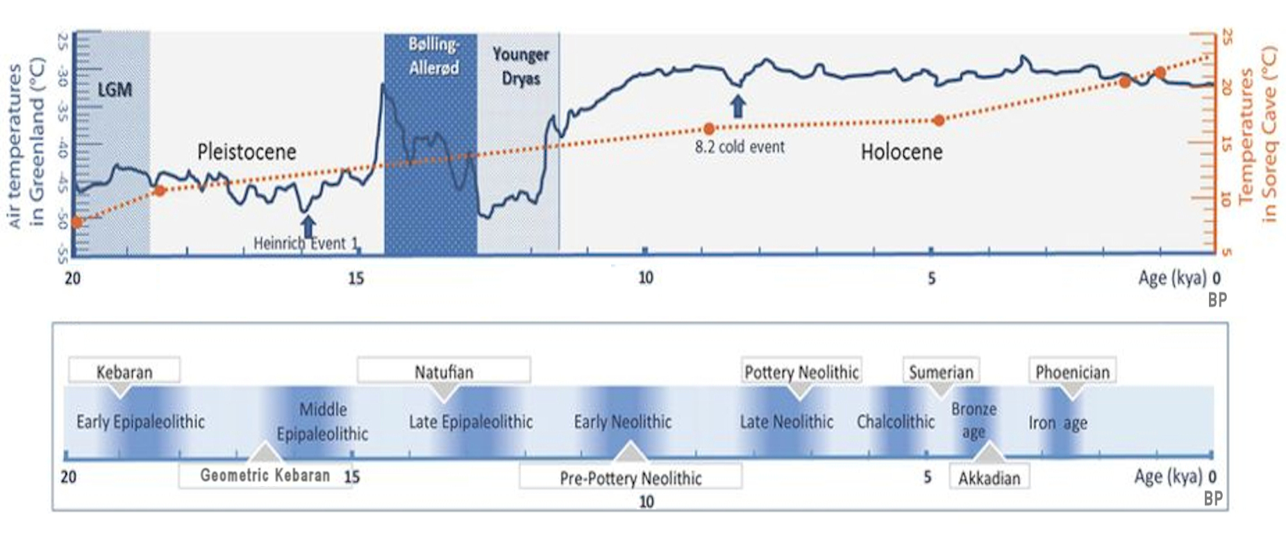
In archaeology, the Epipalaeolithic or Epipaleolithic (sometimes Epi-paleolithic etc.) is a period occurring between the Upper Paleolithic and Neolithic during the Stone Age. Mesolithic also falls between these two periods, and the two are sometimes confused or used as synonyms. More often, they are distinct, referring to approximately the same period of time in different geographic areas. Epipaleolithic always includes this period in the Levant and, often, the rest of the Near East. It sometimes includes parts of Southeast Europe, where Mesolithic is much more commonly used. Mesolithic very rarely includes the Levant or the Near East; in Europe, Epipalaeolithic is used, though not very often, to refer to the early Mesolithic. The Epipalaeolithic has been defined as the "final Upper Palaeolithic industries occurring at the end of the final glaciation which appear to merge technologically into the Mesolithic". The period is generally dated from BP to 10,000 BP in ... [...More Info...] [...Related Items...] OR: [Wikipedia] [Google] [Baidu] |
Palestinian Authority
The Palestinian National Authority (PA or PNA; ar, السلطة الوطنية الفلسطينية '), commonly known as the Palestinian Authority and officially the State of Palestine, Al Jazeera. Accessed 4 July 2021. is the Fatah-controlled government body that exercises partial civil control over West Bank areas "A" and "B" as a consequence of the 1993–1995 . ... [...More Info...] [...Related Items...] OR: [Wikipedia] [Google] [Baidu] |
Nature Reserve
A nature reserve (also known as a wildlife refuge, wildlife sanctuary, biosphere reserve or bioreserve, natural or nature preserve, or nature conservation area) is a protected area of importance for flora, fauna, or features of geological or other special interest, which is reserved and managed for purposes of conservation and to provide special opportunities for study or research. They may be designated by government institutions in some countries, or by private landowners, such as charities and research institutions. Nature reserves fall into different IUCN categories depending on the level of protection afforded by local laws. Normally it is more strictly protected than a nature park. Various jurisdictions may use other terminology, such as ecological protection area or private protected area in legislation and in official titles of the reserves. History Cultural practices that roughly equate to the establishment and maintenance of reserved areas for animals date bac ... [...More Info...] [...Related Items...] OR: [Wikipedia] [Google] [Baidu] |
Urim, Israel
Urim ( he, אוּרִים, ''lit.'' Lights) is a kibbutz in the Negev desert in southern Israel. Located near the border of the Gaza Strip and about 30 kilometers west of Beersheba, the kibbutz falls under the jurisdiction of Eshkol Regional Council. In it had a population of . History Urim was established in 1948, on land which had belonged to the Palestinian village of Al-Imara. Al-Imara became depopulated in the 1948 Arab–Israeli War, and Urim was established about 1 km south of the village site. The community was founded in Ra'anana in 1945 by Bulgarian immigrants from the Gordonia and Maccabi Youth groups, but most of the later settlement came from North Americans from Habonim. The kibbutz itself was settled on 6 October 1946 as one of the 11 points in the Negev 11 points in the Negev ( he, 11 הנקודות or he2, אחת-עשרה הנקודות, ''Akhat-Esre HaNekudot'') refers to a Jewish Agency plan to establish 11 settlements in the Negev in 1946 prior to t ... [...More Info...] [...Related Items...] OR: [Wikipedia] [Google] [Baidu] |
Re'im
Re'im ( he, רֵעִים, lit. ''Friends'') is a secular kibbutz in southern Israel, and one of the Gaza vicinity villages. Located at the confluence of Besor Stream and Gerar Stream in the north-western Negev desert, it falls under the jurisdiction of Eshkol Regional Council. In it had a population of . Re'im was founded in 1949 by members of the Israel Boy and Girl Scouts Federation who were demobilized from the Palmach. Geography Re'im is located between roads 232 and 234 in the western Negev, next to the Re'im Junction and Gama Junction. The ruins of ancient Gama (Tell Jemmeh) are located to the west of the kibbutz. West of Re'im is the kibbutz Kissufim, and north is Be'eri. Re'im's elevation is 50 m above sea level, and the Besor Stream passes through its territory. History The kibbutz was established in 1949 by former Palmach members with the provisional name HaTzofim Vav (''lit.'' Scouts F). It was then named Tel Re'im ( he, תל רעים, lit. ''Hill of Friends'') afte ... [...More Info...] [...Related Items...] OR: [Wikipedia] [Google] [Baidu] |
Tze'elim
Tze'elim ( he, צֶאֱלִים) is a kibbutz in southern Israel. Located in the Negev desert, it falls under the jurisdiction of Eshkol Regional Council. In it had a population of . A military training base of the ground forces of the IDF (often named "Tze'elim Base") is located nearby. History The kibbutz was founded in January 1947 by gar'in from Jewish youth movements in Eastern Europe and North Africa, and was named for the abundant acacia trees in the area, which were mistakenly identified as the biblical ''Tze'elim'' trees. During the 1948 Arab–Israeli War the kibbutz was used as a military base. Many of the Selvino children were settled in the kibbutz. Economy Today the kibbutz markets itself as a tourist destination, with a natural hot springs spa and accommodation. Other economic activities are agriculture and farming. A 120 MW solar power plant, Israel's largest to date, opened in the kibbutz in 2020. The production plant for cleantech materials made out of u ... [...More Info...] [...Related Items...] OR: [Wikipedia] [Google] [Baidu] |
Al-Khalasa
Al-Khalasa ( ar, الخلصة, al-Khalasah; he, אל-ח'אלצה, ''al-Khalatsah''), was a Palestinian village, located 23 kilometers southwest of the town of Beersheba. The village stood at the site of an ancient town from the Nabatean, Roman, Byzantine, and the beginning of the Early Muslim period. The ancient city, founded by the Nabateans, is known from Greek and Roman sources as "Halasa" or "Chellous", and later as "Elusa", one of the Byzantine administrative centers in the Negev Desert. Still important in the century of the Muslim conquest, it was deserted not long after. The site was repopulated by Bedouin in the early twentieth century, after western archaeologists took an interest in it. In October 1948, it was captured by Israel during the 1948 Arab-Israeli War. The population of al-Khalasa is unknown, but all of the inhabitants were Muslims, from the al-Azizma tribe. History Nabataean, Roman, and Byzantine periods The ancient site was founded by the Nabateans, proba ... [...More Info...] [...Related Items...] OR: [Wikipedia] [Google] [Baidu] |
Haluza
The ancient city of Halasa or Chellous ( gr, Χελλοὺς), Elusa () in the Byzantine period, was a city in the Negev near present-day Kibbutz Mash'abei Sadeh that was once part of the Nabataean Incense Route. It lay on the route from Petra to Gaza.Carta's Official Guide to Israel, 1983. Today it is known as Haluza ( he, חלוצה), and during periods of Arab habitation it was known as al-Khalūṣ ( ar, الخلوص; Early Muslim period) and Al-Khalasa (; 20th century). In the 5th century it was surrounded by vineyards and was famous for its wines. Due to its historic importance, UNESCO declared Haluza a World Heritage Site along with Mamshit, Avdat and Shivta. Name in ancient sources The city is called 'Chellous' (Χελλοὺς) in the Greek text of Judith, i, 9 (seJdt 1:9in NABRE), a work probably dating to the 1st century BCE. It is also mentioned in the 2nd century CE by Ptolemy, Peutinger's Table, Stephanus Byzantius (fl. 6th century; as being formerly i ... [...More Info...] [...Related Items...] OR: [Wikipedia] [Google] [Baidu] |
Ashalim
Ashalim ( he, אֲשָׁלִים) is a small community settlement in southern Israel. Located in the Negev desert about 35 km south of Be'er Sheva and on the eastern side of Nahal Besor, the largest stream in the Negev, it falls under the jurisdiction of the Ramat HaNegev Regional Council. In its population was . Nearby settlements include Ezuz and Nitzana. History The original village of Ashalim was one of three nahal settlements founded between Mashabei Sadeh and Nitzana in 1956. The name itself means Tamarixes, a genus of shrubs and small trees. The new Ashalim was founded as moshav shitufi in 1979 after moving from Bir Asluj Hill close to Golda Park, a nearby artificial lake. Today Ashalim functions as a community settlement. Kfar Adiel students village In 2003 Kfar Adiel, a village for students of the Ben-Gurion University of the Negev, was founded near Ashalim by the Ayalim Association, whose objective is to establish settlements for students and small entreprene ... [...More Info...] [...Related Items...] OR: [Wikipedia] [Google] [Baidu] |


