|
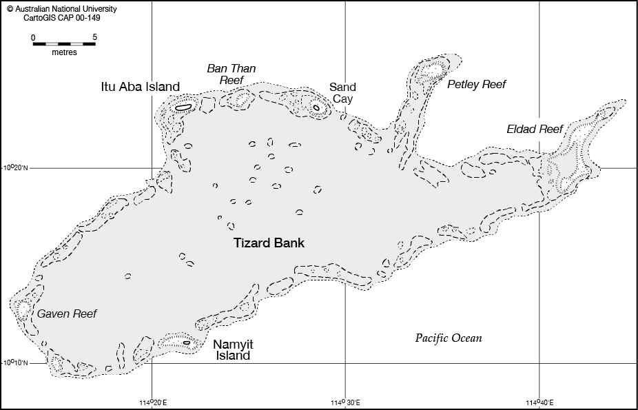
Tizard Bank
The Tizard Bank, is a partially sunken atoll and one of the significant maritime features of the north-western part of the Spratly Islands. It is claimed by the People's Republic of China, the Republic of China, and Vietnam, and various parts of it are occupied by these states. It was named after Thomas Henry Tizard (1839 – 17 February 1924), a British oceanographer and surveyor who surveyed the bank from aboard HMS ''Rifleman'' in the 1860s. In 1947 the Republic of China government gave the bank the name Zheng He Archipelago after the famous Ming-era admiral, although there is no evidence that he ever visited Tizard Bank. From before the 1870s the islands were used by fishermen from Hainan with Itu Aba Island having a semi-permanent settlement of Chinese fishermen. The bank rises steeply from surrounding depths ranging from 500 to 700 meters. It is in length, and extends west from the Gaven Reefs to the NW of Dangerous Ground. [...More Info...] [...Related Items...] OR: [Wikipedia] [Google] [Baidu] |
Atoll
An atoll () is a ring-shaped island, including a coral rim that encircles a lagoon partially or completely. There may be coral islands or cays on the rim. Atolls are located in warm tropical or subtropical oceans and seas where corals can grow. Most of the approximately 440 atolls in the world are in the Pacific Ocean. Two different, well-cited models, the subsidence and antecedent karst models, have been used to explain the development of atolls.Droxler, A.W. and Jorry, S.J., 2021. ''The Origin of Modern Atolls: Challenging Darwin's Deeply Ingrained Theory.'' ''Annual Review of Marine Science'', 13, pp.537-573. According to Charles Darwin's ''subsidence model'', the formation of an atoll is explained by the subsidence of a volcanic island around which a coral fringing reef has formed. Over geologic time, the volcanic island becomes extinct and eroded as it subsides completely beneath the surface of the ocean. As the volcanic island subsides, the coral fringing reef becomes a ... [...More Info...] [...Related Items...] OR: [Wikipedia] [Google] [Baidu] |
Sand Cay
A cay ( ), also spelled caye or key, is a small, low-elevation, sandy island on the surface of a coral reef. Cays occur in tropical environments throughout the Pacific, Atlantic, and Indian Oceans, including in the Caribbean and on the Great Barrier Reef and Belize Barrier Reef. Etymology The 1492 indigenous people of the Bahamas were called " Lucayan", an Anglicization of the Spanish ''Lucayos'', derived in turn from the Taíno ''Lukku-Cairi'' (which the people used for themselves), meaning "people of the islands". The Taíno word for "island", ''cairi'', became ''cayo'' in Spanish and "cay" in English (spelled "key" in American English, "caye" in Belizean English). Formation and composition A cay forms when ocean currents transport loose sediment across the surface of a reef to where the current slows or converges with another current, releasing its sediment load. Gradually, layers of deposited sediment build up on the reef surface – a '' depositional node''. Such n ... [...More Info...] [...Related Items...] OR: [Wikipedia] [Google] [Baidu] |
Union Banks
Union Banks (Pagkakaisa Banks and Reefs) is a large drowned atoll in the center of Dangerous Ground in the Spratly Islands in South China Sea, west of the Philippine coast, containing islands and reefs whose ownership remains disputed and controversial. The closest atoll is Tizard Bank, due north of Union Banks. There are only two natural islands on the rim of the reef, Sin Cowe Island and Sin Cowe East Island. The atoll is long from Johnson South Reef in the southwest to Whitson Reef in the northeast, and up to wide. Its total area measures . The central lagoon is up to deep. Islands and reefs comprising Union Banks Union Banks consists of the following islands and reefs, clockwise starting in the southwest corner:- Version dated 19 August 2011 is available at: Key: = occupied by PRC; = occupied by Vietnam See also *List of maritime features in the Spratly Islands This page features a series of lists of maritime features in the Spratly Islands. Feat ... [...More Info...] [...Related Items...] OR: [Wikipedia] [Google] [Baidu] |
Discovery Great Reef
Discovery Great Reef ( tl, Bahura ng Paredes); Lớn Reef ( vi, Đá Lớn); Mandarin , is a reef on the Spratly Islands in the South China Sea. The reef has been occupied by Vietnam since 1988. It is also claimed by China (PRC), the Philippines, Vietnam Vietnam or Viet Nam ( vi, Việt Nam, ), officially the Socialist Republic of Vietnam,., group="n" is a country in Southeast Asia, at the eastern edge of mainland Southeast Asia, with an area of and population of 96 million, making i ..., and Taiwan (ROC). See also * Spratly Islands dispute References External linksMaritime Transparency Initiative Island Tracker {{island-stub Reefs of the Spratly Islands Reefs of Vietnam ... [...More Info...] [...Related Items...] OR: [Wikipedia] [Google] [Baidu] |
Loaita Bank
The Loaita Bank () is one of the significant maritime features in the Spratly Islands. It is about long on its NE-SW axis, and extends from Loaita Island to the NW of Dangerous Ground.NGA Chart 93044 shows the area NW of Dangerous Ground. The bank contains a number of maritime features, including shoals, reefs, an island, two sand cays, and a lagoon: * Loaita Island () * () * Loaita Nan (Loaita Southwest Reef) [...More Info...] [...Related Items...] OR: [Wikipedia] [Google] [Baidu] |

