|
Transylvanian Saxon University
The Transylvanian Saxon University (, , , ) was an official governing body of the Transylvanian Saxon community in Transylvania during the Late Middle Ages up until the late Modern Age. The Saxon University was led by the Saxon Count (, ). The Saxon University () was constituted at the royal order of Hungarian King Matthias Corvinus in 1486. From 1486 up until 1876, the Saxon University worked as a self-governing (or autonomous) administrative body of the Saxon ethnicity in the Principality of Transylvania and then in the Grand Principality of Transylvania (from 1765 onwards). From 1876 up until the year of its dissolution in 1937, the Saxon University became and functioned as a foundation of the Transylvanian Saxons, thereby coordinating the activity of their schools and Evangelical Lutheran churches (i.e. subordinated to the Evangelical Church of the Augsburg Confession) in the process. Name The name can be quite problematic at first glance given the fact that it does n ... [...More Info...] [...Related Items...] OR: [Wikipedia] [Google] [Baidu] |
Universitatea Saseasca Sapte Scaune CoA
Universitatea () may refer to: *CS Universitatea Craiova, Romanian football club *FC Universitatea Cluj, Romanian football club * Universitatea Cluj, Romanian sports club (except football) See also *Universitario (other) Universitario is Spanish for university student. It is the name of several football clubs, sports clubs, and stadiums in Latin America and Europe. Universitario may refer to: Clubs Football *Club Universitario de Deportes, a Peruvian football club ... * Universidad (other) * {{disambig ... [...More Info...] [...Related Items...] OR: [Wikipedia] [Google] [Baidu] |
Bistrița
(; , archaic , Transylvanian Saxon: , ) is the capital city of Bistrița-Năsăud County, in northern Transylvania, Romania. It is situated on the Bistrița River. The city has a population of 78,877 inhabitants as of 2021 and administers six villages: (; ), (; ), (; ), (; ), (until 1950 ; ; ) and (; ). There is a project for the creation of a metropolitan area that will contain the municipality of Bistrița and 3 surrounding localities ( Șieu-Măgheruș, Budacu de Jos, and Livezile), whose combined population would be over 91,600 inhabitants. Etymology The town was named after the River, whose name comes from the Slavic word meaning 'fast-moving water'. History The earliest sign of settlement in the area of is in Neolithic remains. The Turkic Pechenegs settled the area in 12th century following attacks of the Cumans. Transylvanian Saxons settled the area in 1206 and called the region . A large part of settlers were fugitives, convicts, and poor people looking ... [...More Info...] [...Related Items...] OR: [Wikipedia] [Google] [Baidu] |
Zipser Germans
The Zipser Germans, Zipser Saxons, or, simply, just Zipsers (, , , ) are a German-speaking (more specifically Zipser German-speaking as native dialect) sub-ethnic group in Central- Eastern Europe and national minority in both Slovakia and Romania (there are also Zipser German settlements in the Zakarpattia Oblast, in the historical region of Carpathian Ruthenia, present-day western Ukraine). Along with the Sudeten Germans (), the Zipser Germans were one of the two most important ethnic German groups in the former Czechoslovakia. An occasional variation of their name as 'Tzipsers' can also be found in academic articles. Former Slovak President Rudolf Schuster is partly Zipser German and grew up in Medzev (). The Zipser Germans were previously native to the Szepes County (; , ) of Upper Hungary—today mostly north-eastern Slovakia—as that region was settled by colonists from present-day central Germany (and other parts of contemporary Germany) during the High Middle Ages, ... [...More Info...] [...Related Items...] OR: [Wikipedia] [Google] [Baidu] |
Szepes County
Szepes (; , , ) was an administrative county of the Kingdom of Hungary, called Scepusium before the late 19th century. Its territory today lies in northeastern Slovakia, with a very small area in southeastern Poland. For the current region, see Spiš. Geography Szepes county shared borders with Poland and with the counties as follows: Liptó County, Liptó, Gömör és Kishont County, Gömör-Kishont, Abaúj-Torna County, Abaúj-Torna and Sáros County, Sáros. After the late 18th century dismemberment of Poland, the border was with the Austrian province of Galicia (Central Europe), Galicia. Its area was 3,668 km2 in 1910. The county became part of Czechoslovakia, apart from a Czechoslovak-Polish border dispute (1918-1947), very small area now in Poland, after World War I, and is now part of Slovakia (and Poland). Capitals The original seat of government of Szepes county was Spiš Castle (), which was constructed in the 12th century. Unofficially from the 14th century, and ... [...More Info...] [...Related Items...] OR: [Wikipedia] [Google] [Baidu] |
Spiš
Spiš ( ; or ; ) is a region in north-eastern Slovakia, with a very small area in south-eastern Poland (more specifically encompassing 14 former Slovak villages). Spiš is an informal designation of the territory, but it is also the name of one of the 21 official tourism regions of Slovakia. The region is not an administrative division in its own right, but between the late 11th century and 1918 it was an administrative county of the Kingdom of Hungary (see separate article Szepes County in this regard). Etymology The name is probably related to the appellative ''spiška'', ''špiška'' known from Slovak (Eastern Slovakia and Orava) and Moravian dialects ( Haná) - a (cut) stick, a piece of wood or sugar, etc. Old Slavic ''pьchjati'', ''pichjati'' - to stab, to cut → prefixed form sъ-pich-jь → after palatalization and extinction of yers ''spiš''. Spiš probably means "a cut forest". The theory is supported also by the fact that almost all early Latin documents ment ... [...More Info...] [...Related Items...] OR: [Wikipedia] [Google] [Baidu] |
Slovakia
Slovakia, officially the Slovak Republic, is a landlocked country in Central Europe. It is bordered by Poland to the north, Ukraine to the east, Hungary to the south, Austria to the west, and the Czech Republic to the northwest. Slovakia's mostly mountainous territory spans about , hosting a population exceeding 5.4 million. The capital and largest city is Bratislava, while the second largest city is Košice. The Slavs arrived in the territory of the present-day Slovakia in the 5th and 6th centuries. From the late 6th century, parts of modern Slovakia were incorporated into the Pannonian Avars, Avar Khaghanate. In the 7th century, the Slavs played a significant role in the creation of Samo's Empire. When the Avar Khaghanate dissolved in the 9th century, the Slavs established the Principality of Nitra before it was annexed by the Great Moravia, Principality of Moravia, which later became Great Moravia. When Great Moravia fell in the 10th century, the territory was integrated i ... [...More Info...] [...Related Items...] OR: [Wikipedia] [Google] [Baidu] |
Romanians
Romanians (, ; dated Endonym and exonym, exonym ''Vlachs'') are a Romance languages, Romance-speaking ethnic group and nation native to Central Europe, Central, Eastern Europe, Eastern, and Southeastern Europe. Sharing a Culture of Romania, common culture and Cultural heritage, ancestry, they speak the Romanian language and live primarily in Romania and Moldova. The 2021 Romanian census found that 89.3% of Romania's citizens identified themselves as ethnic Romanians. In one interpretation of the 1989 census results in Moldova, the majority of Moldovans were counted as ethnic Romanians as well.''Ethnic Groups Worldwide: A Ready Reference Handbook By'' David Levinson (author), David Levinson, Published 1998 – Greenwood Publishing Group.At the time of the 1989 census, Moldova's total population was 4,335,400. The largest nationality in the republic, ethnic Romanians, numbered 2,795,000 persons, accounting for 64.5 percent of the population. Source U.S. Library of Congres ... [...More Info...] [...Related Items...] OR: [Wikipedia] [Google] [Baidu] |
Diploma Andreanum
The ''Diploma Andreanum'', or ''Der Goldener Freibrief der Siebenbürger Sachsen'' (English: ''Golden Charter of the Transylvanian Saxons''), was issued by King Andrew II of Hungary in 1224, granting provisional autonomy to colonial Germans residing in the region of Transylvania () of the then Kingdom of Hungary, more specifically the present-day area of Sibiu (), central Romania Romania is a country located at the crossroads of Central Europe, Central, Eastern Europe, Eastern and Southeast Europe. It borders Ukraine to the north and east, Hungary to the west, Serbia to the southwest, Bulgaria to the south, Moldova to .... References 1224 in Europe 13th-century documents 13th-century Latin literature Medieval texts in Latin Medieval documents Medieval charters and cartularies of Hungary 13th century in Hungary Medieval Transylvania Hungarian German communities Transylvanian Saxon people {{Hungary-hist-stub ... [...More Info...] [...Related Items...] OR: [Wikipedia] [Google] [Baidu] |
Transylvanian Diet
The Transylvanian Diet (; ; ) was an important legislative, administrative and judicial body of the Principality (from 1765 Grand Principality) of Transylvania between 1570 and 1867. The general assemblies of the Transylvanian noblemen and the joint assemblies of the representatives of the " Three Nations of Transylvania"the noblemen, Székelys and Saxonsgave rise to its development. After the disintegration of the medieval Kingdom of Hungary in 1541, delegates from the counties of the eastern and northeastern territories of Hungary proper (or Partium) also attained the Transylvanian Diet, transforming it into a legal successor of the medieval Diets of Hungary. The diet sessions at Vásárhely (now Târgu Mureș) (20 January 1542) and at Torda (now Turda) (2 March 1542) laid the basis for the political and administrative organization of Transylvania. The diet decided on juridical, military and economic matters. It ceased to exist following the Austro-Hungarian Compromise of 1867 ... [...More Info...] [...Related Items...] OR: [Wikipedia] [Google] [Baidu] |
Székelys
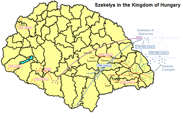
The Székelys (, Old Hungarian script, Székely runes: ), also referred to as Szeklers, are a Hungarians, Hungarian subgroup living mostly in the Székely Land in Romania. In addition to their native villages in Suceava County in Bukovina, a significant population descending from the Székelys of Bukovina currently lives in Tolna County, Tolna and Baranya County, Baranya counties in Hungary and certain districts of Vojvodina, Serbia. In the Middle Ages, the Székelys played a role in the defense of the Kingdom of Hungary#Middle Ages, Kingdom of Hungary against the Ottoman Empire, Ottomans in their posture as guards of the eastern border. With the Treaty of Trianon of 1920, Transylvania (including the Székely Land) became part of Romania, and the Székely population was a target of Romanianization efforts. In 1952, during the Socialist Republic of Romania, communist rule of Romania, the former counties with the highest concentration of Székely population – Mureș County#His ... [...More Info...] [...Related Items...] OR: [Wikipedia] [Google] [Baidu] |
Hungarians In Romania
The Hungarian minority of Romania (, ; ) is the largest Minorities of Romania, ethnic minority in Romania. As per the 2021 Romanian census, 1,002,151 people (6% of respondents) declared themselves Hungarian, while 1,038,806 people (6.3% of respondents) stated that Hungarian language, Hungarian was their mother tongue. Most Hungarians, ethnic Hungarians of Romania live in areas that were parts of Hungary before the Treaty of Trianon of 1920. Encompassed in a region known as Transylvania, the most prominent of these areas is known generally as Székely Land (; ), where Hungarians comprise the majority of the population. Transylvania, in the larger sense, also includes the historic regions of Banat, Crișana and Maramureș. There are forty-one counties of Romania; Hungarians form a large majority of the population in the counties of Harghita County, Harghita (85.21%) and Covasna County, Covasna (73.74%), and a large percentage in Mureș County, Mureș (38.09%), Satu Mare Count ... [...More Info...] [...Related Items...] OR: [Wikipedia] [Google] [Baidu] |
Sibiu P-ta Mare Nr
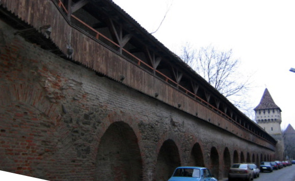
Sibiu ( , , , Hungarian: ''Nagyszeben'', , Transylvanian Saxon dialect, Transylvanian Saxon: ''Härmeschtat'' or ''Hermestatt'') is a city in central Romania, situated in the historical region of Transylvania. Located some north-west of Bucharest, the city straddles the Cibin, Cibin River, a tributary of the Olt (river), Olt River. Now the seat of Sibiu County, between 1692 and 1791 and 1849–65 Sibiu was the capital of the Principality of Transylvania (1711–1867), Principality of Transylvania. Until 1876, the Hecht hause in Sibiu served as the seat of the Transylvanian Saxon University. Nicknamed ''The Town with Eyes'' for the Eyebrow dormer, eyebrow dormers on many old buildings, the town is a popular tourist destination. It is known for its culture, history, cuisine, and architecture. In 2004, its historical center was added to the tentative list of UNESCO World Heritage Sites. Sibiu was subsequently designated the European Capital of Culture in 2007, along with Luxemb ... [...More Info...] [...Related Items...] OR: [Wikipedia] [Google] [Baidu] |


