|
Strathpeffer
Strathpeffer ( gd, Srath Pheofhair) is a village and spa town in Ross and Cromarty, Highland, Scotland, with a population of 1,469. Geography It lies in a strath west of Dingwall, with the elevation ranging from above sea level. Sheltered on the west and north, it has a comparatively dry and warm climate. History The strategic location of the village has led to several battles being fought in the area : *Blar Nan Ceann (battle (field) of the heads), lies at the western end of the modern village (). Very little is known about the battle there, not even its date, other than the MacKenzies of Seaforth defeated the MacDonells of Glengarry and some incident took place at a well near the battlefield, subsequently called Tobar a' Chinn (well of the head). * Battle of Blar Na Pairce (battle (field) of the park), in approximately 1486 saw the local MacKenzies, under their chief Kenneth MacKenzie, defeat a large invading force of MacDonalds. The battlefield lies south-west of the m ... [...More Info...] [...Related Items...] OR: [Wikipedia] [Google] [Baidu] |
Highland Museum Of Childhood
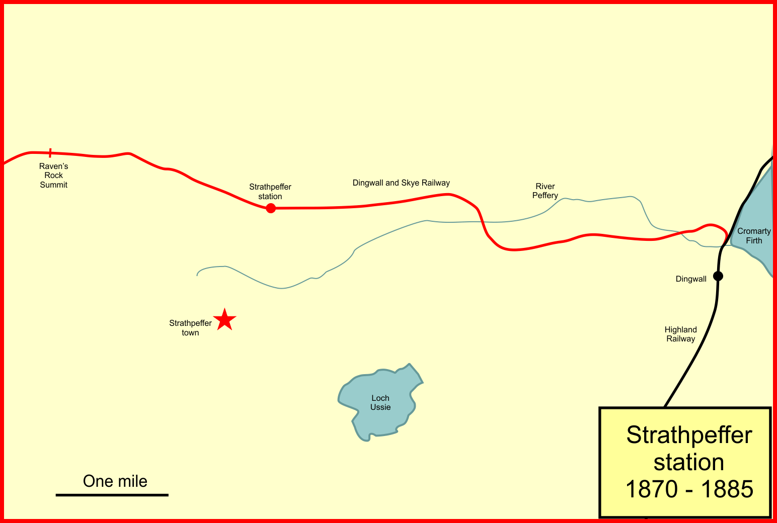
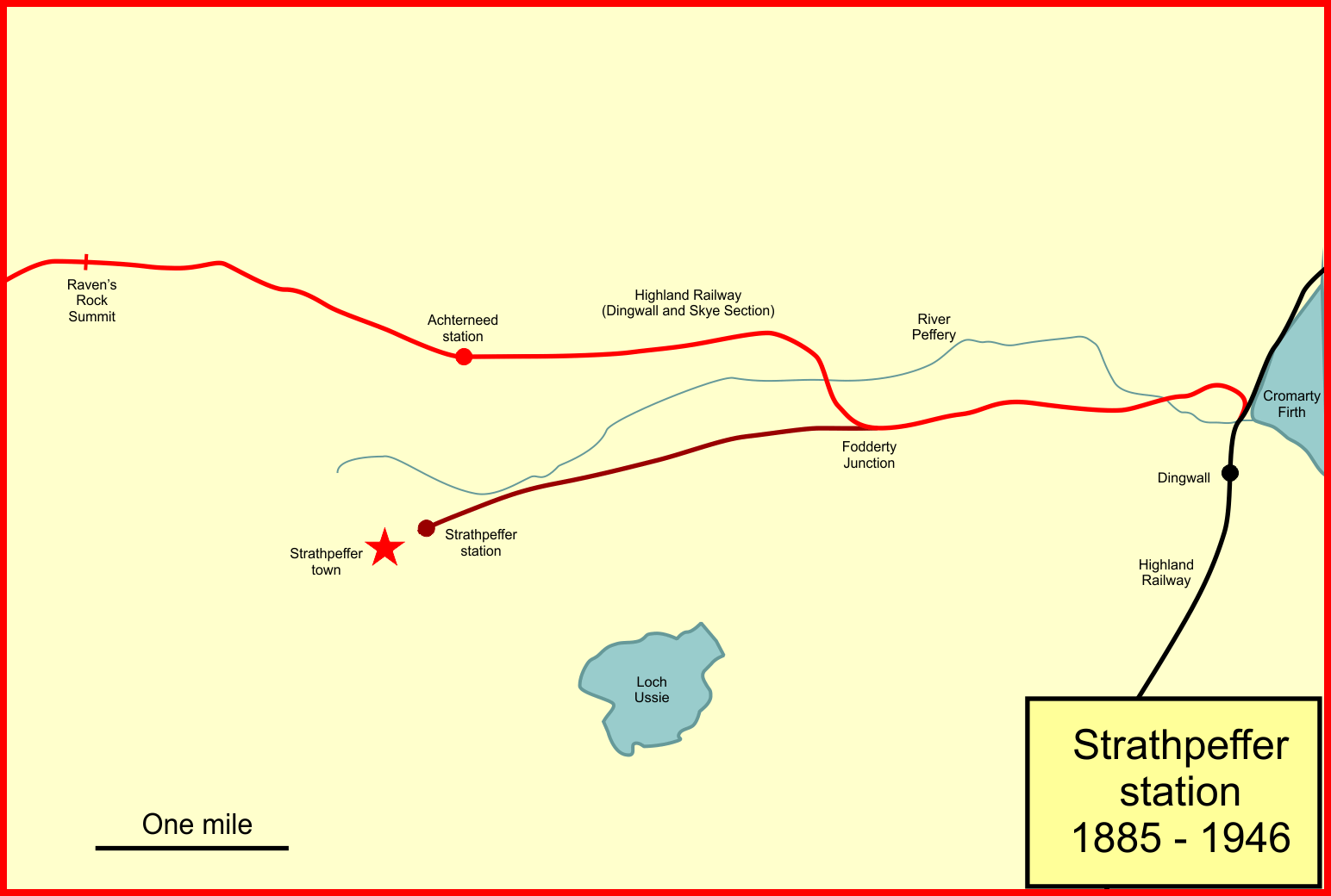
Strathpeffer railway station was a railway station serving the town of Strathpeffer in the county of Ross and Cromarty, (later Highland Region), Scotland. The first station was located some distance from the town, on the Dingwall and Skye Railway line, and was opened in 1870. Seasonal visitors to Strathpeffer increased considerably in numbers, and a branch line to Strathpeffer itself was opened in 1885; the earlier station was renamed Achterneed. Tourism increased considerably, but the First World War interrupted the leisure development, and it never recovered after the war. In 1946 the second Strathpeffer station was closed to passengers. The earlier station, now called Achterneed, continued in use, being located on a through line, but it closed in 1964. First station On 5 July 1865 the Dingwall and Skye Railway was authorised by Act of Parliament; it was an ambitious scheme to build westwards from Dingwall on the Inverness and Ross-shire Railway to Kyle of Lochalsh on the we ... [...More Info...] [...Related Items...] OR: [Wikipedia] [Google] [Baidu] |
Strathpeffer Railway Station
Strathpeffer railway station was a railway station serving the town of Strathpeffer in the county of Ross and Cromarty, (later Highland Region), Scotland. The first station was located some distance from the town, on the Dingwall and Skye Railway line, and was opened in 1870. Seasonal visitors to Strathpeffer increased considerably in numbers, and a branch line to Strathpeffer itself was opened in 1885; the earlier station was renamed Achterneed. Tourism increased considerably, but the First World War interrupted the leisure development, and it never recovered after the war. In 1946 the second Strathpeffer station was closed to passengers. The earlier station, now called Achterneed, continued in use, being located on a through line, but it closed in 1964. First station On 5 July 1865 the Dingwall and Skye Railway was authorised by Act of Parliament; it was an ambitious scheme to build westwards from Dingwall on the Inverness and Ross-shire Railway to Kyle of Lochalsh on the wes ... [...More Info...] [...Related Items...] OR: [Wikipedia] [Google] [Baidu] |
Strathpeffer Pavilion
Strathpeffer Spa Pavilion () was commissioned by the Countess of Cromartie in the late 19th century, to serve as a social and entertainment centre for Strathpeffer's many visitors. Formerly just a collection of farms in a Scottish Highland Strath, the village of Strathpeffer developed and became a popular health resort (then the most northerly spa in Europe) in the Victorian era, when local spring waters were discovered to have health-giving properties. Opened by the Countess of Cromartie in 1881, the Pavilion provided entertainment in the form of dances, concerts, lectures etc. Famous speakers included suffragette Emmeline Pankhurst and explorer Ernest Shackleton. During the First World War (1914–18), many of the large houses and hotels in Strathpeffer were requisitioned by the armed forces and the Pavilion was taken over by the US Navy and used as a hospital. After the War, the popularity of the spa declined and the Pavilion was used only as an occasional venue for event ... [...More Info...] [...Related Items...] OR: [Wikipedia] [Google] [Baidu] |
The Eagle Stone
(in English, the "Sounding Stone") or The Eagle Stone is a small Class I Pictish stone located on a hill on the northern outskirts of Strathpeffer in Easter Ross, Scotland. Description The stone is made of blue gneiss and is high, wide, and thick.. Has some nice pictures, including drawings of the images Carved on the southeast side are two images, a horse shoe-like arc symbol above an eagle. History The stone was originally located further down the hill, towards Dingwall, but was moved to its current site in 1411. One old tradition is that the stone marks the site of a Scottish clan battle that took place in 1411 between the Clan Munro and a branch of the Clan MacDonald, and that the stone commemorates a Munro victory as it is marked with their symbol, an eagle. According to Norman Macrae the stone was placed there by the Munros while marching against Donald of Islay, Lord of the Isles Donald, Lord of the Isles ( gd, Dómhnall; died 1423), was the son and successo ... [...More Info...] [...Related Items...] OR: [Wikipedia] [Google] [Baidu] |
Battle Of Blar Na Pairce
The Battle of Blar na Pairce ( gd, Blàr na Pàirce "Battle of the Park") was a Scottish clan battle that took place just outside Strathpeffer some time between 1485 and 1491. It was fought between men of the Clan Donald or MacDonald and the Clan Mackenzie (led by Kenneth Mackenzie). The chief of Clan Donald, Lord of the Isles, had resigned the title of Earl of Ross to the king in 1477. After this the province of Ross was constantly invaded by the MacDonald islanders. As a result, a battle was fought between the Clan Donald islanders, led by Gillespick MacDonald against the Clan MacKenzie. The MacDonald islanders were defeated with many men being drowned in the River Conon The River Conon ( gd, Conann) is a river in the Highlands of Scotland. It begins at Loch Luichart, and flows in a south-easterly direction to be joined by the River Meig at Scatwell before passing through Loch Achonachie. It is joined by the B .... References Bibliography * * 15th-century ... [...More Info...] [...Related Items...] OR: [Wikipedia] [Google] [Baidu] |
Battle Of Drumchatt
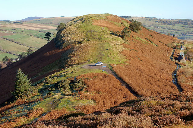
The Battle of Drumchatt was a Scottish clan battle that took place in 1497. The Clan Mackenzie and possibly the Clan Munro defeated the Clan MacDonald of Lochalsh at Drumchatt (Druimchat) or "the Cat's Back", a ridge to the southeast of Strathpeffer. Background In 1493, the powerful chief of the Clan Donald, Sir John of Islay, lost his right to the title of Lord of the Isles when it was revoked by James IV of Scotland, having also already forfeited the title of Earl of Ross in 1475. As a result, many of the western and other northern clans, particularly the Clan MacLeod of Harris and Dunvegan, felt that they no longer had to pledge allegiance to the MacDonalds. In 1495, King James assembled an army at Glasgow. Then, on 18 May, many of the highland chiefs made their submissions to him, including those of the Clan Mackenzie and Clan Munro. This may explain the unusual alliance between the Munros and Mackenzies who were rival clans. However, while the presence of the Clan ... [...More Info...] [...Related Items...] OR: [Wikipedia] [Google] [Baidu] |
Castle Leod
Castle Leod is the seat of the Clan Mackenzie. It is a category A listed building, and the grounds are listed in the ''Inventory of Gardens and Designed Landscapes of Scotland'', the national listing of significant gardens. It is located near Strathpeffer in the east of Ross-shire in the Scottish Highlands. History Background The castle was granted to John of Killin, 10th Chief of Clan MacKenzie (1485–1561) after he fought at the Battle of Flodden. The castle was passed to his great-grandson Kenneth Mackenzie, 1st Lord Mackenzie of Kintail, who granted it in 1608 to his brother Sir Roderick "Rorie" Mackenzie. In 1605 Sir Roderick married Margaret MacLeod, heiress of Torquil MacLeod of Lewis, bringing her immense wealth into the family and also settling the feud between the MacLeods and the Mackenzies over the Barony of Coigach, which thus passed into the Mackenzie family. Castle history The castle is believed to have been built on the site of a very ancient Pictish fort ... [...More Info...] [...Related Items...] OR: [Wikipedia] [Google] [Baidu] |
Caithness, Sutherland And Ross (Scottish Parliament Constituency)
Caithness, Sutherland and Ross (Gaelic: ''Gallaibh, Cataibh agus Ros'') is a constituency of the Scottish Parliament covering the northern part of the Highland council area. It elects one Member of the Scottish Parliament (MSP) by the first past the post method of election. It is also one of eight constituencies in the Highlands and Islands electoral region, which elects seven additional members, in addition to eight constituency MSPs, to produce a form of proportional representation for the region as a whole. The constituency was formed for the 2011 Scottish Parliament election, and replaced Caithness, Sutherland and Easter Ross and part of Ross, Skye and Inverness West. The seat has been held by Maree Todd of the Scottish National Party since the 2021 Scottish Parliament election. Electoral region The Caithness, Sutherland and Ross constituency is part of the Highlands and Islands electoral region; the other seven constituencies are Argyll and Bute, Inverness an ... [...More Info...] [...Related Items...] OR: [Wikipedia] [Google] [Baidu] |
Strathpuffer
The Strathpuffer is an annual amateur 24-hour winter Mountain bike race in the Scottish Highlands. The race is held in late January near Strathpeffer with around 17 hours of the race taking place in darkness. It was first held in 2006 and attracted more than 1,000 competitors in 2018. History The circuit is circa 12.5 kilometre route through the Torrachilty Forest, on the outskirts of Contin. Competitors can enter as a solo rider, or as part of a team of two or fours. Alternatively, schools can also enter teams of eight. Around 17 hours of the race are in darkness. In 2016 there were over 800 participants who faced mud and snow. By that point it had established a reputation as being one of the toughest mountain bike events in the world. In 2017 there were 6,583 laps completed by competitors. In 2018 the race attracted over 1,000 participants. Guy Martin Guy Martin (born 4 November 1981) is a British former motorcycle racer and heavy vehicle mechanic who became a telev ... [...More Info...] [...Related Items...] OR: [Wikipedia] [Google] [Baidu] |
Clan Mackenzie
Clan Mackenzie ( gd, Clann Choinnich ) is a Scottish clan, traditionally associated with Kintail and lands in Ross-shire in the Scottish Highlands. Traditional genealogies trace the ancestors of the Mackenzie chiefs to the 12th century. However, the earliest Mackenzie chief recorded by contemporary evidence is Alexander Mackenzie of Kintail who died some time after 1471. Traditionally, during the Wars of Scottish Independence, the Mackenzies supported Robert the Bruce, but feuded with the Earls of Ross in the latter part of the 14th century. During the 15th and 16th-centuries the Mackenzies feuded with the neighboring clans of Munro and MacDonald. In the 17th century the Mackenzie chief was made Earl of Seaforth in the peerage of Scotland. During the Scottish Civil War of the 17th century the Mackenzies largely supported the Royalists. During the Jacobite rising of 1715 the chief and clan of Mackenzie supported the Jacobite cause. However, during the Jacobite rising of 17 ... [...More Info...] [...Related Items...] OR: [Wikipedia] [Google] [Baidu] |
Ross And Cromarty
Ross and Cromarty ( gd, Ros agus Cromba), sometimes referred to as Ross-shire and Cromartyshire, is a variously defined area in the Highlands and Islands of Scotland. There is a registration county and a lieutenancy area in current use, the latter of which is in extent. Historically there has also been a constituency of the Parliament of the United Kingdom (1832 to 1983), a local government county (1890 to 1975), a district of the Highland local government region (1975 to 1996) and a management area of the Highland Council (1996 to 2007). The local government county is now divided between two local government areas: the Highland area and Na h-Eileanan Siar (the Western Isles). Ross and Cromarty border Sutherland to the north and Inverness-shire to the south. The county was formed by the uniting of the shires of Ross-shire and Cromartyshire. Both these shires had themselves been formed from the historic province of Ross, out of which the many enclaves and exclaves that for ... [...More Info...] [...Related Items...] OR: [Wikipedia] [Google] [Baidu] |
Highland (council Area)
Highland ( gd, A' Ghàidhealtachd, ; sco, Hieland) is a council area in the Scottish Highlands and is the largest local government area in the United Kingdom. It was the 7th most populous council area in Scotland at the 2011 census. It shares borders with the council areas of Aberdeenshire, Argyll and Bute, Moray and Perth and Kinross. Their councils, and those of Angus and Stirling, also have areas of the Scottish Highlands within their administrative boundaries. The Highland area covers most of the mainland and inner-Hebridean parts of the historic counties of Inverness-shire and Ross and Cromarty, all of Caithness, Nairnshire and Sutherland and small parts of Argyll and Moray. Despite its name, the area does not cover the entire Scottish Highlands. Name Unlike the other council areas of Scotland, the name ''Highland'' is often not used as a proper noun. The council's website only sometimes refers to the area as being ''Highland'', and other times as being '' ... [...More Info...] [...Related Items...] OR: [Wikipedia] [Google] [Baidu] |


.jpg)


.jpg)