|
Snowpatch Spire
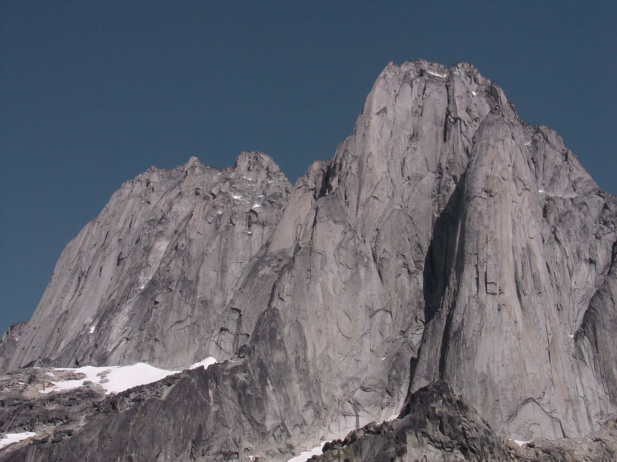
Snowpatch Spire is a mountain peak in British Columbia, Canada. With its first ascent in 1940, it was the last of the Bugaboo Spires to be climbed. It is located southwest of the Conrad Kain hut, across the Crescent Glacier. Routes * Wildflowers * Kraus McCarthy * Sunshine * Surf's Up! (''aka'' Southwest Ridge) * Southeast Corner (''aka'' Snowpatch Route) Nearby * Conrad Kain hut * Bugaboo Spire * Pigeon Spire * Howser Spire Howser Spire, or Howser Spire Massif, is a group of three distinct granite peaks, and the highest mountain of the Canadian Bugaboo Spires. The mountain is located at the southwest corner of the Vowell Glacier, within the Bugaboo mountain range ... * Marmolata Spire References External links * Columbia Valley Three-thousanders of British Columbia Purcell Mountains Kootenay Land District {{BritishColumbiaInterior-geo-stub ... [...More Info...] [...Related Items...] OR: [Wikipedia] [Google] [Baidu] |
The Bugaboos
The Bugaboos are a mountain range in the Purcell Mountains of eastern British Columbia, Canada. The granite spires of the group are a popular mountaineering destination. The Bugaboos are protected within Bugaboo Provincial Park. Geography The Bugaboos are located in the northwestern extreme of the Purcells in the Columbia Mountains, in the south-east of the province. The nearest towns are Radium and Golden. They are commonly subdivided into four divisions: the Bugaboo Glacier Peaks, and the Eastern, Central, and Western Spires. The nearby Vowell and Conrad Groups are usually considered separate from the Bugaboos. Geology Located in the snow- and rain-heavy "Columbia Wet Belt", this section of the Purcells is subject to heavy erosion and large, active glaciers. Originally covered in weaker rock, glaciation eventually revealed the granodiorite batholiths which form the group's distinctive spires. The surrounding rock is approximately 600 million to 1 billion years old, wh ... [...More Info...] [...Related Items...] OR: [Wikipedia] [Google] [Baidu] |
Granite
Granite () is a coarse-grained ( phaneritic) intrusive igneous rock composed mostly of quartz, alkali feldspar, and plagioclase. It forms from magma with a high content of silica and alkali metal oxides that slowly cools and solidifies underground. It is common in the continental crust of Earth, where it is found in igneous intrusions. These range in size from dikes only a few centimeters across to batholiths exposed over hundreds of square kilometers. Granite is typical of a larger family of ''granitic rocks'', or '' granitoids'', that are composed mostly of coarse-grained quartz and feldspars in varying proportions. These rocks are classified by the relative percentages of quartz, alkali feldspar, and plagioclase (the QAPF classification), with true granite representing granitic rocks rich in quartz and alkali feldspar. Most granitic rocks also contain mica or amphibole minerals, though a few (known as leucogranites) contain almost no dark minerals. Granite is near ... [...More Info...] [...Related Items...] OR: [Wikipedia] [Google] [Baidu] |
Columbia Valley
The Columbia Valley is the name used for a region in the Rocky Mountain Trench near the headwaters of the Columbia River between the town of Golden and the Canal Flats. The main hub of the valley is the town of Invermere. Other towns include Radium Hot Springs, Windermere Windermere (sometimes tautologically called Windermere Lake to distinguish it from the nearby town of Windermere) is the largest natural lake in England. More than 11 miles (18 km) in length, and almost 1 mile (1.5 km) at its wides ... and Fairmont Hot Springs. The Panorama Ski Resort is located near the valley. The Columbia Valley is home to the Columbia Wetlands, a vital link on a major bird migration route. External links Columbia Headwaters Legacy ProgramColumbia Valley, BC€”Business Directory, Local Online Newspaper, Live Webcams Valleys of British Columbia {{BritishColumbiaInterior-geo-stub ... [...More Info...] [...Related Items...] OR: [Wikipedia] [Google] [Baidu] |
Howser Spire
Howser Spire, or Howser Spire Massif, is a group of three distinct granite peaks, and the highest mountain of the Canadian Bugaboo Spires. The mountain is located at the southwest corner of the Vowell Glacier, within the Bugaboo mountain range in the Purcell Mountains, a subrange of British Columbia's Columbia Mountains, The highest of the three spires is the North Tower at , the Central Tower the lowest, and the South Tower is slightly lower than the North at . Howser Spire is named after the town of Howser on Duncan Lake and Howser Creek. The first ascent of the North Tower was made in August 1916 by Conrad Kain Conrad Kain (10 August 1883, Nasswald – 2 February 1934, Cranbrook, British Columbia) was an Austrian mountain guide who guided extensively in Europe, Canada, and New Zealand, and was responsible for the first ascents of more than 60 routes in B ..., Albert MacCarthy, E. MacCarthy, J. Vincent and Henry . The Beckey-Chouinard/West Buttress route is recognized ... [...More Info...] [...Related Items...] OR: [Wikipedia] [Google] [Baidu] |
Bugaboo Spire
Bugaboo Spire is a peak in Bugaboo mountain range in Canada, located between the Vowell and Crescent glaciers, just under 2 km West of the ACC's Conrad Kain hut. It is known for its alpine climbing. The Spire was first climbed by Conrad Kain Conrad Kain (10 August 1883, Nasswald – 2 February 1934, Cranbrook, British Columbia) was an Austrian mountain guide who guided extensively in Europe, Canada, and New Zealand, and was responsible for the first ascents of more than 60 routes in B ... in 1916. Routes * Northeast Ridge ( D-, 5.8) :This route tackles the right-hand skyline in the east face photo. Gain the Bugaboo/Crescent col by making your way up the Crescent Glacier to its highest point and scrambling (4th class) up the extreme left side of a slabby grey-green area for about 180m. You are then on the ridge joining Crescent and Bugaboo; follow blocks and a large crack up this to the "rope-up terrace", a white area where dykes on the east face join the ridge. From her ... [...More Info...] [...Related Items...] OR: [Wikipedia] [Google] [Baidu] |
Mountain
A mountain is an elevated portion of the Earth's crust, generally with steep sides that show significant exposed bedrock. Although definitions vary, a mountain may differ from a plateau in having a limited summit area, and is usually higher than a hill, typically rising at least 300 metres (1,000 feet) above the surrounding land. A few mountains are isolated summits, but most occur in mountain ranges. Mountains are formed through tectonic forces, erosion, or volcanism, which act on time scales of up to tens of millions of years. Once mountain building ceases, mountains are slowly leveled through the action of weathering, through slumping and other forms of mass wasting, as well as through erosion by rivers and glaciers. High elevations on mountains produce colder climates than at sea level at similar latitude. These colder climates strongly affect the ecosystems of mountains: different elevations have different plants and animals. Because of the less hospitable ter ... [...More Info...] [...Related Items...] OR: [Wikipedia] [Google] [Baidu] |
American Alpine Journal
The ''American Alpine Journal'' is an annual magazine published by the American Alpine Club. Its mission is "to document and communicate mountain exploration." The headquarters is in Golden, Colorado. Subtitled as a compilation of "The World's Most Significant Climbs," the magazine contains feature stories about notable new routes and ascents, written by the climbers, as well as a large "Climbs and Expeditions" section containing short notes by climbers about new and noteworthy achievements. Some general articles about mountaineering, mountain medicine, the mountain environment, or other topics are also sometimes included. Each issue includes book reviews, memorials of deceased members, and club activities. History The journal was established in 1929. In 1957 and 1958, the editor was Francis P. Farquhar. From 1960 to 1995, the editor was H. Adams Carter, who brought the journal to international pre-eminence. From 1996 to 2001, the editor was Christian Beckwith. Since 2002, the ... [...More Info...] [...Related Items...] OR: [Wikipedia] [Google] [Baidu] |
National Topographic System
The National Topographic System or NTS is the system used by Natural Resources Canada for providing general purpose topographic maps of the country. NTS maps are available in a variety of scales, the standard being 1:50,000 and 1:250,000 scales. The maps provide details on landforms and terrain, lakes and rivers, forested areas, administrative zones, populated areas, roads and railways, as well as other man-made features. These maps are currently used by all levels of government and industry for forest fire and flood control (as well as other environmental issues), depiction of crop areas, right-of-way, real estate planning, development of natural resources and highway planning. To add context, land area outside Canada is depicted on the 1:250,000 maps, but not on the 1:50,000 maps. History Topographic mapping in Canada was originally undertaken by many different agencies, with the Canadian Army’s Intelligence Branch forming a survey division to create a more standardized mappin ... [...More Info...] [...Related Items...] OR: [Wikipedia] [Google] [Baidu] |
Pigeon Spire
Pigeon Spire is a peak in the Purcell Mountains of the Columbia Mountains in southeastern British Columbia, Canada. It may be one of the most climbed of the spires in The Bugaboos The Bugaboos are a mountain range in the Purcell Mountains of eastern British Columbia, Canada. The granite spires of the group are a popular mountaineering destination. The Bugaboos are protected within Bugaboo Provincial Park. Geography Th ... owing to its relatively low prominence from the Vowell Glacier and the existence of an easy route (the West Ridge; II, 5.4). It is not uncommon to have a couple dozen people on this route on a busy weekend. There are longer, harder routes on the spire's North and East faces. Routes * West Ridge (II, 5.4) External links Pigeon Spire at Bivouac.com Three-thousanders of British Columbia Columbia Valley Purcell Mountains Kootenay Land District {{BritishColumbiaInterior-geo-stub ... [...More Info...] [...Related Items...] OR: [Wikipedia] [Google] [Baidu] |
East Kootenay
The Regional District of East Kootenay (RDEK) is a regional district in the Canadian province of British Columbia, Canada. In the 2016 census, the population was 60,439. Its area is . The regional district offices are in Cranbrook, the largest community in the region. Other important population centres include the cities of Kimberley and Fernie, and the district municipality of Invermere and Sparwood. Despite its name, the regional district does not include all of the region known as the East Kootenay, which includes the Creston Valley and the east shore of Kootenay Lake. Geography The regional district's dominant landform is the Rocky Mountain Trench, which is flanked by the Purcell Mountains and Rocky Mountains on the east and west, and includes the Columbia Valley region, the southern half of which is in the regional district (its northern half is in the Columbia-Shuswap Regional District). Another distinct area within the regional district is the Elk Valley in the ... [...More Info...] [...Related Items...] OR: [Wikipedia] [Google] [Baidu] |
Purcell Mountains
The Purcell Mountains are a mountain range in southeastern British Columbia, Canada. They are a subrange of the Columbia Mountains, which includes the Selkirk, Monashee, and Cariboo Mountains. They are located on the west side of the Rocky Mountain Trench in the area of the Columbia Valley, and on the east side of the valley of Kootenay Lake and the Duncan River. The only large settlements in the mountains are the Panorama Ski Resort and Kicking Horse Resort, adjacent to the Columbia Valley towns of Invermere and Golden, though there are small settlements, such as Yahk and Moyie along the Crowsnest Highway, and residential rural areas dependent on the cities of Creston, Kimberley and Cranbrook, which are located adjacent to the range. The Purcells are shown on some United States maps as the Percell Mountains, where their southern limit protrudes into the states of Idaho and Montana, abutting Lake Koocanusa, a reservoir on the Kootenai River. American geographic classificatio ... [...More Info...] [...Related Items...] OR: [Wikipedia] [Google] [Baidu] |


