|
Sesheke
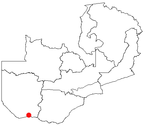
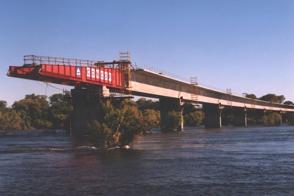
Sesheke is a border town in the Western Province of Zambia, in a district of the same name. It lies on the northern bank of the Zambezi River which forms the border with Namibia's Caprivi Strip at that point. The Katima Mulilo Bridge, completed in May 2004, spans the river here, connecting Sesheke with the Namibian town of Katima Mulilo. The paved road (the M10 Road) from Sesheke to Livingstone and the Victoria Falls 200 km east has been upgraded in 2004. The new bridge and road were financed by German donor bank Kreditanstalt für Wiederaufbau and were the last missing link in the so-called "Trans Caprivi Corridor" (today known as the Walvis Bay-Ndola-Lubumbashi Development Road). This 2500 km long asphalt road now connects Zambia's Copperbelt with Namibia's sea port Walvis Bay. As a direct result, the amount of road freight traffic has greatly increased. An investment and construction boom is rapidly transforming both Sesheke and Katima Mulilo, as well as s ... [...More Info...] [...Related Items...] OR: [Wikipedia] [Google] [Baidu] |
Sesheke District
Sesheke District is a district of Zambia, located in Western Province. The capital lies at Sesheke. As of the 2000 Zambian Census, the district had a population of 78,169 people. It contains Sioma Ngwezi National Park and contains part of the Zambezi River, which forms Zambia's border with Namibia Namibia (, ), officially the Republic of Namibia, is a country in Southern Africa. Its western border is the Atlantic Ocean. It shares land borders with Zambia and Angola to the north, Botswana to the east and South Africa to the south and ea .... References Districts of Western Province, Zambia {{Zambia-geo-stub ... [...More Info...] [...Related Items...] OR: [Wikipedia] [Google] [Baidu] |
Katima Mulilo Bridge
The Katima Mulilo Bridge (also known as ''Bridge 508'' in the Namibian Bridge Register) carries the TransCaprivi Highway over the Zambezi River between Katima Mulilo, Namibia and Sesheke, Zambia. It is a road bridge, completed in 2004, 900 metres long and with 19 spans. It links Namibia's Trans–Caprivi Highway to the Zambian road network, forming a section of the trade route from south-central Africa to the Atlantic known as the Walvis Bay Corridor ( Walvis Bay-Ndola-Lubumbashi Development Road). It also carries tourist traffic."COMMISSIONING CEREMONY OF THE KATIMA-MULILO BRIDGE AND THE LIVINGSTONE/SESHEKE ROAD, 13 MAY 2004" Speech of Dr. Sam Nujoma [...More Info...] [...Related Items...] OR: [Wikipedia] [Google] [Baidu] |
Western Province, Zambia
Western Province is one of the 10 provinces in Zambia and encompasses most of the area formerly known as Barotseland. The capital is Mongu, and together with the neighbouring town of Limulunga, Mongu is treated as the capital of Barotseland. Geography The geography of the province is dominated by the Barotse Floodplain of the Zambezi river, extending from the confluence of the Zambezi with the Lungwebungu and Kabompo Rivers at the northern border of the province, to a point below Senanga and above the Ngonye Falls in the south. This floodplain is inundated from December to June, and is fed by other rivers with their own floodplains, and serves as a vast reservoir storing the waters of the Zambezi. The seasonal flooding is very important to agriculture in the province, providing natural irrigation for the grasslands on which huge herds of cattle depend, and bringing water to the settlements along the edges of the plain. Away from the Zambezi and its tributaries, much of the ... [...More Info...] [...Related Items...] OR: [Wikipedia] [Google] [Baidu] |
Senanga
Senanga is the capital of the Senanga District, which is located in the Western Province of Zambia. The town is situated on the eastern bank of the Zambezi River, at the southern end of the Barotse Floodplain. It lies on the main road running parallel to the river from Livingstone and Sesheke to Mongu, which crosses the river by a pontoon ferry about 15 km (9 mi) south of Senanga. Recently the Kaunga Lyeti Bridge was completed to cross the Kaunga Lyeti River near the junction to Sioma, traveling from Sesheke and Katima Mulilo. On top of the bridgework, recent road projects (the roads to Mongu and Sesheke) have improved travel conditions and inspired economic confidence and growth. In addition to the river and floodplain with its wildlife and fishing opportunities, Senanga is about 120 km (75 mi) from Sioma Ngwezi National Park and about 80 km (50 mi) from Ngonye Falls. It has a hotel and serves as a base for fishing tours by boat. A tall radio mast ... [...More Info...] [...Related Items...] OR: [Wikipedia] [Google] [Baidu] |
Zambezi River
The Zambezi River (also spelled Zambeze and Zambesi) is the fourth-longest river in Africa, the longest east-flowing river in Africa and the largest flowing into the Indian Ocean from Africa. Its drainage basin covers , slightly less than half of the Nile's. The river rises in Zambia and flows through eastern Angola, along the north-eastern border of Namibia and the northern border of Botswana, then along the border between Zambia and Zimbabwe to Mozambique, where it crosses the country to empty into the Indian Ocean. The Zambezi's most noted feature is Victoria Falls. Its other falls include the Chavuma Falls at the border between Zambia and Angola, and Ngonye Falls near Sioma in western Zambia. The two main sources of hydroelectric power on the river are the Kariba Dam, which provides power to Zambia and Zimbabwe, and the Cahora Bassa Dam in Mozambique, which provides power to Mozambique and South Africa. Additionally, two smaller power stations are along the Zambezi R ... [...More Info...] [...Related Items...] OR: [Wikipedia] [Google] [Baidu] |
Walvis Bay-Ndola-Lubumbashi Development Road
The Walvis Bay-Ndola-Lubumbashi Development Road (previously ''Trans-Caprivi Corridor'' and until 2004 ''Trans-Caprivi-Highway'', accessed on 27 August 2014.) runs from Walvis Bay, through Rundu in north eastern Namibia, along the Caprivi Strip to Katima Mulilo on the Zambezi River, which forms the border between Namibia and Zambia. The Katima Mulilo Bridge spans the river to the Zambian town of Sesheke from where a recently upgraded paved road runs to Livingstone (the M10 Road) joining the main north–south highway to Lusaka, connecting onwards to the Copperbelt. The Trans-Caprivi highway is a section of the Walvis Bay Corridor, a trade route linking land-locked Zambia (and neighbouring countries such as DR Congo, Malawi and Zimbabwe) to the Walvis Bay port on the Atlantic Ocean. An example of the function of the corridor as a trade route is that trucks carry copper ore concentrate from the Dikulushi Mine in South-East DR Congo across Zambia and down the Trans-Capriv ... [...More Info...] [...Related Items...] OR: [Wikipedia] [Google] [Baidu] |
Livingstone, Zambia
Livingstone is a city in Zambia. Until 1935, it served as the capital city of Zambia (then Northern Rhodesia). Lying 10 km (6.2 mi) to the north of the Zambezi River, it is a tourism attraction center for the Victoria Falls and a border town with road and rail connections to Zimbabwe on the other side of the Victoria Falls. A historic British colonial city, its present population was enumerated at 134,349 inhabitants at the 2010 census. It is named after David Livingstone, the Scottish explorer and missionary who was the first European to explore the area. Pre-colonial History Mukuni, to the south-east of present-day Livingstone, was the largest village in the area before Livingstone was founded. Its Baleya inhabitants, originally from the Rozwi culture in Zimbabwe, were conquered by Chief Mukuni who came from the Congo in the 16th century. Another group of Baleya under Chief Sekute lived near the river west of the town. The predominant people in the area, though, we ... [...More Info...] [...Related Items...] OR: [Wikipedia] [Google] [Baidu] |
Katima Mulilo
Katima Mulilo or simply Katima is the capital of the Zambezi Region in Namibia. It is located in the Caprivi Strip. It had 28,362 inhabitants in 2010, and comprises two electoral constituencies, Katima Mulilo Rural and Katima Mulilo Urban. It is located on the national road B8 on the banks of the Zambezi River in lush riverine vegetation with tropical birds and monkeys. The town receives an annual average rainfall of . The nearest Namibian town to Katima Mulilo is Rundu, about 500 km away. About 40 km east of Katima Mulilo lies the village of Bukalo, where the road to Ngoma branches off that joins Namibia to Botswana. Economy and infrastructure Established and run as a garrison for a long time, Katima Mulilo still shows signs of its military role today. In the city centre was the South African Defence Force military base, almost every house had a bomb shelter. The town benefited from the military presence in terms of infrastructure and employment, and there ar ... [...More Info...] [...Related Items...] OR: [Wikipedia] [Google] [Baidu] |
Districts Of Zambia
The ten provinces of Zambia are divided into a total of 116 districts as of 2018. Article 109 in part VIII of the constitution of Zambia deals with local government. It states only that there should be some form of local government, and that this local government should be based on democratically elected councils on the basis of universal adult suffrage. Provincial Districts in Zambia Until 2011, Zambia was subdivided into 72 districts. However, since 2011, a number of new districts have been created, bringing the total to 116 as of 2018. ;Total Districts by Province # Central Province (11 districts) # Copperbelt Province (10 districts) # Eastern Province (15 districts) # Luapula Province (12 districts) # Lusaka Province (6 districts) # Muchinga Province (8 districts) # Northern Province (12 districts) # North-Western Province (11 districts) # Southern Province (15 districts) # Western Province (16 districts) Central Province Central Province is composed of 11 di ... [...More Info...] [...Related Items...] OR: [Wikipedia] [Google] [Baidu] |
Mongu
Mongu is the capital of Western Province in Zambia and was the capital of the formerly-named province and historic state of Barotseland. Its population is 179,585 (2010 census), and it is also the headquarters of Mongu District. History Mongu was once the capital of the Kingdom of Barotseland from British colonial rule until Zambia's unilateral independence in the Barotse Agreement in 1964. It is home to the Lozi people who migrated to the Barotse floodplains from the Luba Empire more than 500 years ago. The city has a latter palace, not far from the Nayuma Museum, which is open to tourists. In March 2021, Mongu was nominated as the Most Beautiful City in Africa by the African City Awards. Provincial Administration Western Province like so many other provinces in Zambia such as Southern Province and North-Western Province is headed by a full cabinet Minister and there are Ministries of Central government for each province. The Administrative head the Province is the ... [...More Info...] [...Related Items...] OR: [Wikipedia] [Google] [Baidu] |
Barotse Floodplain
The Barotse Floodplain, also known as the Bulozi Plain, Lyondo or the Zambezi Floodplain, is one of Africa's great wetlands, on the Zambezi River in the Western Province of Zambia. It is a designated Ramsar site, regarded as being of high conservation value. The name recognises the floodplain as spawning the culture and way of life of the Lozi people, "Rotse" being a variant of ''Lozi'', and "Ba" meaning "people". They became a powerful kingdom in Central/Southern Africa under their king or litunga Lewanika, whose realm extended up to 300 km from the plain and was called Barotseland. Topography and area The region is a flat plateau at an elevation of about 1000 m tilting very slightly to the south. The Zambezi and its headwaters rise on the higher ground to the north, which enjoys good rainfall (1400 mm annually) in a rainy season from October to May. A flood moves down the river reaching a flat region, formed from Kalahari sands, about five hundred kilometres acro ... [...More Info...] [...Related Items...] OR: [Wikipedia] [Google] [Baidu] |


