|
Sentinel Mesa
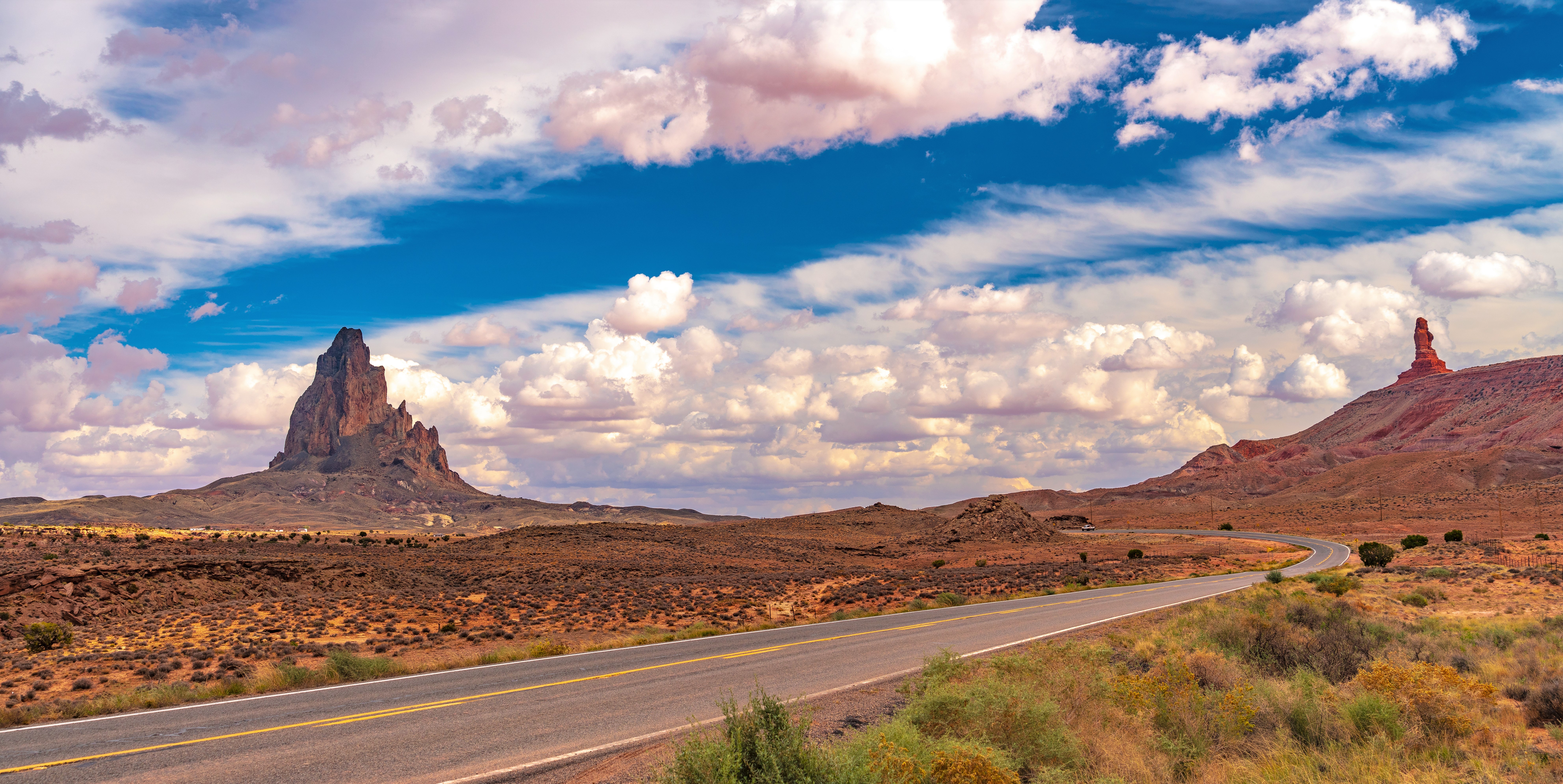
Sentinel Mesa is a summit in San Juan County, Utah, United States. It is situated north of the Monument Valley visitor center on Navajo Nation land and can be seen from Highway 163. The mesa is immediately northwest of the iconic West and East Mitten Buttes. The nearest higher neighbor is Brighams Tomb, to the north-northeast. Precipitation runoff from this mesa's west slope drains to Mitchell Butte Wash, whereas the east slope drains to West Gypsum Creek, which are both part of the San Juan River drainage basin. The "Sentinel" name refers to how the mesa oversees Monument Valley which the Navajo consider as one of the " door posts" to Monument Valley. The landform's toponym has been officially adopted by the U.S. Board on Geographic Names. Geology Sentinel Mesa is a mesa composed of three principal strata. The bottom layer is Organ Rock Shale, the next stratum is De Chelly Sandstone, and the upper layer is Moenkopi Formation capped by Shinarump Conglomerate. The rock ra ... [...More Info...] [...Related Items...] OR: [Wikipedia] [Google] [Baidu] |
Mitchell Mesa
Mitchell Mesa is a summit in Navajo County, Arizona, Navajo County, Arizona, United States. Description Mitchell Mesa is situated south of the Monument Valley visitor center on Navajo Nation land and can be seen from U.S. Route 163, Highway 163. The large, irregularly-shaped mesa is southwest of the iconic West and East Mitten Buttes. Precipitation runoff from this mesa's west slope drains to Mitchell Butte Wash, whereas the east slope drains to West Gypsum Creek, which are both part of the San Juan River (Colorado River tributary), San Juan River drainage basin. Topographic relief is significant as the summit rises above the surrounding terrain in one-half mile (0.8 km). The nearest higher neighbor is Eagle Mesa, to the north. The Navajo consider Mitchell Mesa as one of the "door posts" to Monument Valley, with the other being Sentinel Mesa. The landform's toponym has been officially adopted by the U.S. Board on Geographic Names. The Mitchell name refers to Hearndon Mitc ... [...More Info...] [...Related Items...] OR: [Wikipedia] [Google] [Baidu] |
Mesa
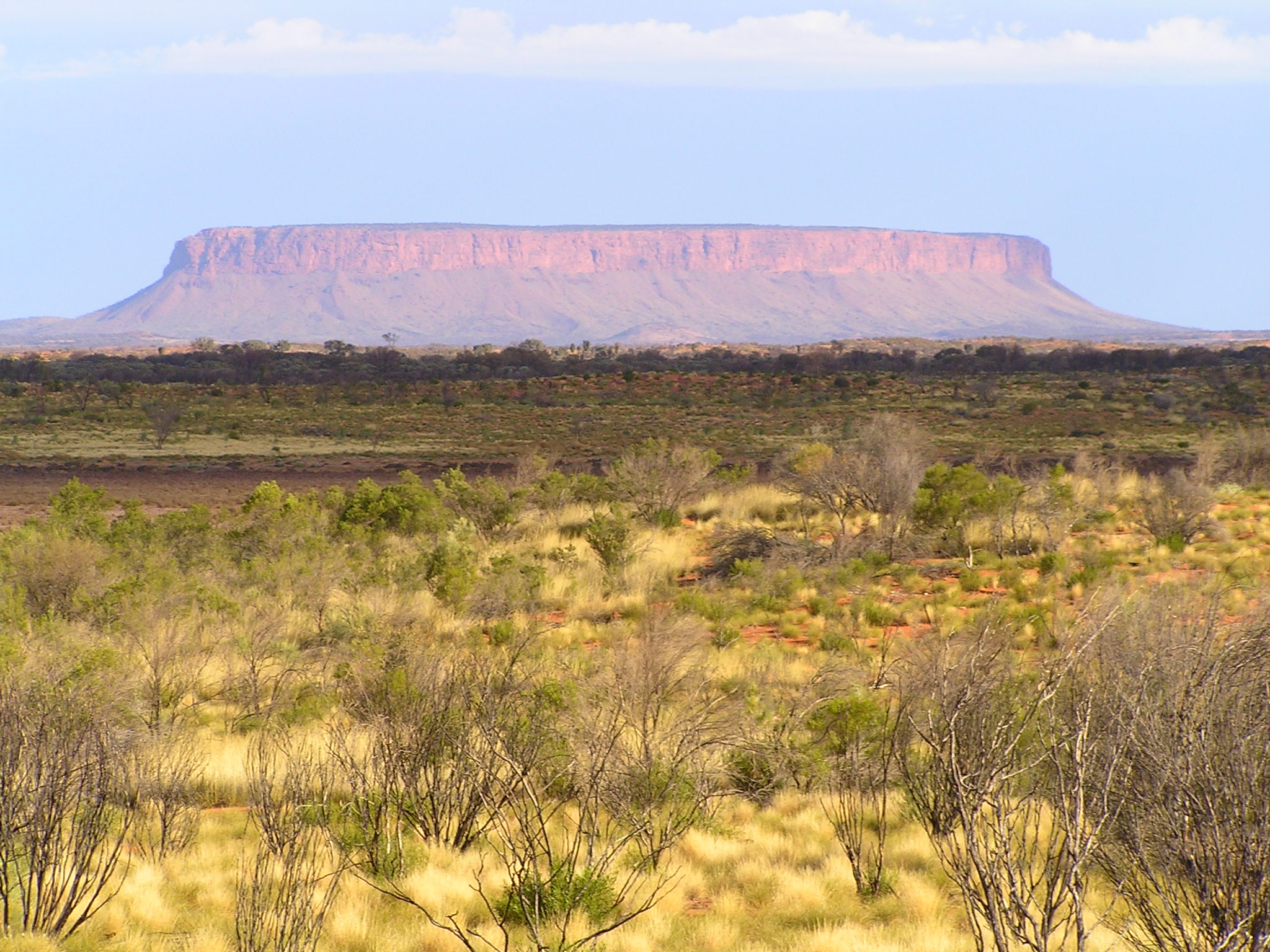
A mesa is an isolated, flat-topped elevation, ridge, or hill, bounded from all sides by steep escarpments and standing distinctly above a surrounding plain. Mesas consist of flat-lying soft sedimentary rocks, such as shales, capped by a resistant layer of harder rock, like sandstone or limestone, forming a caprock that protects the flat summit. The caprock may also include dissected lava flows or eroded duricrust. Unlike a ''plateau'', which is a broader, elevated region that may not have horizontal bedrock (e.g., Tibetan Plateau), a mesa is defined by flat-lying strata and steep-sided isolation. Large, flat-topped plateaus with horizontal strata, less isolated and often part of extensive plateau systems, are called '' tablelands''. A ''butte'' is a smaller, eroded mesa with a limited summit, while a '' cuesta'' has a gentle dip slope and one steep escarpment due to tilted strata.Duszyński, F., Migoń, P. and Strzelecki, M.C., 2019. ''Escarpment retreat in sedim ... [...More Info...] [...Related Items...] OR: [Wikipedia] [Google] [Baidu] |
Oljato–Monument Valley, Utah
Oljato-Monument Valley () is a census-designated place (CDP) in San Juan County, Utah, United States. The population was 864 at the 2000 census. It is the location of Monument Valley. Geography According to the United States Census Bureau, the CDP has a total area of 28.7 square miles (74.4 km), all land. Demographics At the 2000 census, there were 864 people, 207 households, and 174 families in the CDP. The population density was 30.1 people per square mile (11.6/km). There were 275 housing units at an average density of 9.6/sq mi (3.7/km). The racial makeup of the CDP was 94.10% Native American, 5.44% White, 0.12% Pacific Islander, 0.23% from other races, and 0.12% from two or more races. Hispanic or Latino of any race were 0.93% of the population. Of the 207 households 55.1% had children under the age of 18 living with them, 58.0% were married couples living together, 20.8% had a female householder with no husband present, and 15.5% were non-families. ... [...More Info...] [...Related Items...] OR: [Wikipedia] [Google] [Baidu] |
Arizona
Arizona is a U.S. state, state in the Southwestern United States, Southwestern region of the United States, sharing the Four Corners region of the western United States with Colorado, New Mexico, and Utah. It also borders Nevada to the northwest and California to the west, and shares Mexico-United States border, an international border with the Mexican states of Sonora and Baja California to the south and southwest. Its Capital city, capital and List of largest cities, largest city is Phoenix, Arizona, Phoenix, which is the most populous state capital and list of United States cities by population, fifth most populous city in the United States. Arizona is divided into 15 List of counties in Arizona, counties. Arizona is the list of U.S. states and territories by area, 6th-largest state by area and the list of U.S. states and territories by population, 14th-most-populous of the 50 states. It is the 48th state and last of the contiguous United States, contiguous states to be a ... [...More Info...] [...Related Items...] OR: [Wikipedia] [Google] [Baidu] |
List Of Appearances Of Monument Valley In The Media
Monument Valley, located on the Navajo Nation within Arizona and Utah, has been featured in many forms of media since the 1930s. It is perhaps most famous for its use in many John Ford films, such as ''Stagecoach'' (1939) and ''The Searchers'' (1956). It has also been featured in such films as '' Easy Rider'' (1969), directed by and co-starring Dennis Hopper; ''Forrest Gump'' (1994), directed by Robert Zemeckis, and '' The Eiger Sanction'' (1975), directed by and starring Clint Eastwood; and in two episodes of the popular United Kingdom television show ''Doctor Who'': " The Impossible Astronaut" (23 April 2011) and " Day of the Moon" (30 April 2011). The twin buttes of Monument Valley (" the Mittens"), the "Totem Pole", and the "Ear of the Wind" arch, among other features, have developed iconic status. They have appeared in many television programs, commercials, and Hollywood movies, especially Westerns. Motion pictures Films *'' The Vanishing American'' (1925) *'' The Lone ... [...More Info...] [...Related Items...] OR: [Wikipedia] [Google] [Baidu] |
Big Indian (Utah)
Big Indian is a summit in San Juan County, Utah, United States. Description Big Indian is situated north-northeast of the Monument Valley Tribal Park Visitor Center, on Navajo Nation land. It is an iconic landform of Monument Valley and can be seen from Highway 163. Precipitation runoff from this landform's slopes drains into the San Juan River drainage basin. Topographic relief is significant as the summit rises above the surrounding terrain in 0.25 mile (0.4 km). The nearest higher summit is Sentinel Mesa, to the southwest. This landform's toponym was officially adopted in 1964 by the United States Board on Geographic Names. It is so named because the butte resembles the face of a native American looking south-southeast into the valley. "Big Chief" and "Big Indian Butte" were alternate names that were ultimately rejected. Geology Big Indian is composed of two principal strata. The bottom layer is slope-forming Organ Rock Shale underlaying cliff-forming De Ch ... [...More Info...] [...Related Items...] OR: [Wikipedia] [Google] [Baidu] |
Diurnal Temperature Variation
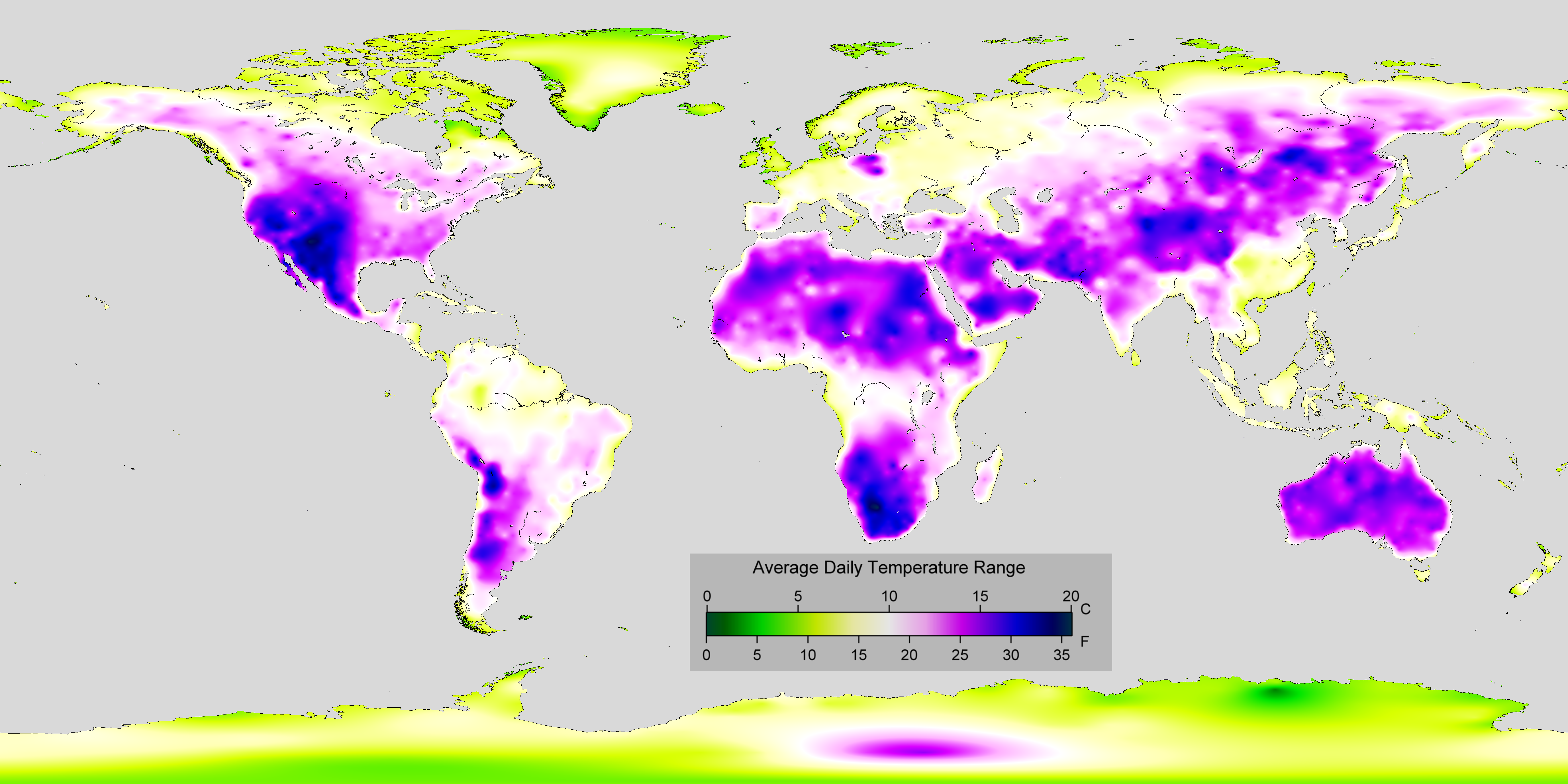
In meteorology, diurnal temperature variation is the variation between a high air temperature and a low temperature that occurs during the same day. Temperature lag Temperature lag, also known as thermal inertia, is an important factor in diurnal temperature variation. Peak daily temperature generally occurs ''after'' noon, as air keeps absorbing net heat for a period of time from morning through noon and some time thereafter. Similarly, minimum daily temperature generally occurs substantially after midnight, indeed occurring during early morning in the hour around dawn, since heat is lost all night long. The analogous annual phenomenon is seasonal lag. As solar energy strikes the Earth's surface each morning, a shallow layer of air directly above the ground is heated by conduction. Heat exchange between this shallow layer of warm air and the cooler air above is very inefficient. On a warm summer's day, for example, air temperatures may vary by from just above the ground t ... [...More Info...] [...Related Items...] OR: [Wikipedia] [Google] [Baidu] |
Semi-arid Climate
A semi-arid climate, semi-desert climate, or steppe climate is a dry climate sub-type. It is located on regions that receive precipitation below potential evapotranspiration, but not as low as a desert climate. There are different kinds of semi-arid climates, depending on variables such as temperature, and they give rise to different biomes. Defining attributes of semi-arid climates A more precise definition is given by the Köppen climate classification, which treats steppe climates (''BSh'' and ''BSk'') as intermediates between desert climates (BW) and humid climates (A, C, D) in ecological characteristics and agricultural potential. Semi-arid climates tend to support short, thorny or scrubby vegetation and are usually dominated by either grasses or shrubs as they usually cannot support forests. To determine if a location has a semi-arid climate, the precipitation threshold must first be determined. The method used to find the precipitation threshold (in millimeters): * ... [...More Info...] [...Related Items...] OR: [Wikipedia] [Google] [Baidu] |
Köppen Climate Classification
The Köppen climate classification divides Earth climates into five main climate groups, with each group being divided based on patterns of seasonal precipitation and temperature. The five main groups are ''A'' (tropical), ''B'' (arid), ''C'' (temperate), ''D'' (continental), and ''E'' (polar). Each group and subgroup is represented by a letter. All climates are assigned a main group (the first letter). All climates except for those in the ''E'' group are assigned a seasonal precipitation subgroup (the second letter). For example, ''Af'' indicates a tropical rainforest climate. The system assigns a temperature subgroup for all groups other than those in the ''A'' group, indicated by the third letter for climates in ''B'', ''C'', ''D'', and the second letter for climates in ''E''. Other examples include: ''Cfb'' indicating an oceanic climate with warm summers as indicated by the ending ''b.'', while ''Dwb'' indicates a semi-Monsoon continental climate, monsoonal continental climate ... [...More Info...] [...Related Items...] OR: [Wikipedia] [Google] [Baidu] |
Late Triassic
The Late Triassic is the third and final epoch (geology), epoch of the Triassic geologic time scale, Period in the geologic time scale, spanning the time between annum, Ma and Ma (million years ago). It is preceded by the Middle Triassic Epoch and followed by the Early Jurassic Epoch. The corresponding series (stratigraphy), series of rock beds is known as the Upper Triassic. The Late Triassic is divided into the Carnian, Norian and Rhaetian Geologic time scale, ages. Many of the first dinosaurs evolved during the Late Triassic, including ''Plateosaurus'', ''Coelophysis'', ''Herrerasaurus'', and ''Eoraptor''. The Triassic–Jurassic extinction event began during this epoch and is one of the five major mass extinction events of the Earth. Etymology The Triassic was named in 1834 by Friedrich August von Namoh, Friedrich von Alberti, after a succession of three distinct rock layers (Greek meaning 'triad') that are widespread in southern Germany: the lower Buntsandstein (colourful ... [...More Info...] [...Related Items...] OR: [Wikipedia] [Google] [Baidu] |
Permian
The Permian ( ) is a geologic period and System (stratigraphy), stratigraphic system which spans 47 million years, from the end of the Carboniferous Period million years ago (Mya), to the beginning of the Triassic Period 251.902 Mya. It is the sixth and last period of the Paleozoic Era; the following Triassic Period belongs to the Mesozoic Era. The concept of the Permian was introduced in 1841 by geologist Sir Roderick Murchison, who named it after the Perm Governorate, region of Perm in Russia. The Permian witnessed the diversification of the two groups of amniotes, the synapsids and the Sauropsida, sauropsids (reptiles). The world at the time was dominated by the supercontinent Pangaea, which had formed due to the collision of Euramerica and Gondwana during the Carboniferous. Pangaea was surrounded by the superocean Panthalassa. The Carboniferous rainforest collapse left behind vast regions of desert within the continental interior. Amniotes, which could better cope with these ... [...More Info...] [...Related Items...] OR: [Wikipedia] [Google] [Baidu] |
Shinarump Conglomerate
The Shinarump Conglomerate is a geologic formation found in the Four Corners region of the United States. It was deposited in the early part of the Late Triassic Period (geology), period. Description The Shinarump Conglomerate is a highly resistant coarse-grained sandstone and pebble conglomerate (minor or major conglomerates are a typical base layer after unconformities or disconformities; the Shinarump is a major conglomerate) with rare lenses of mudstone, sometimes forming a caprock because of its hardness, cementation, and erosion resistance. The Shinarump is found throughout the Colorado Plateau with significant exposures as the canyon rimrock in the vicinity of Canyon De Chelly National Monument, at the north-northeast of the Defiance Plateau/Defiance Uplift. At Canyon De Chelly the Shinarump Conglomerate was laid down upon De Chelly Sandstone-(280 Ma, an erosion unconformity of 50 my), in a region at the west foothill region of the mostly north–south trending Chuska Mount ... [...More Info...] [...Related Items...] OR: [Wikipedia] [Google] [Baidu] |


