|
Sacbe
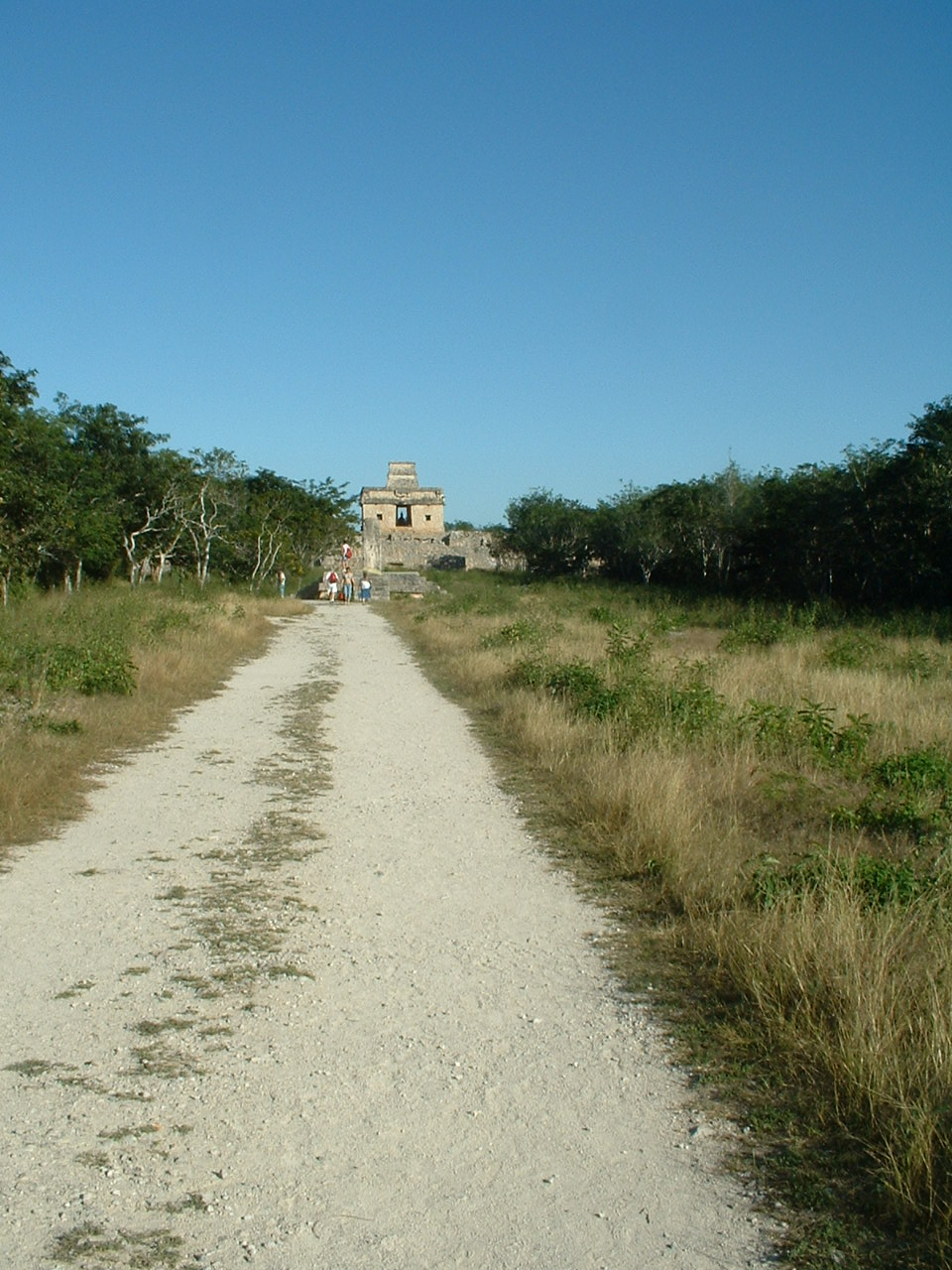
A sacbe, plural sacbeob (Yucatec Maya: singular ''sakbej'', plural ''sakbejo'ob''), or "white road", is a raised paved road built by the Maya civilization of pre-Columbian Mesoamerica. Most connect temples, plazas, and groups of structures within ceremonial centers or cities, but some longer roads between cities are also known. The term "sacbe" is Yucatec Maya language, Yucatec Maya for "white road"; white perhaps because there is evidence that they were originally coated with limestone stucco or plaster, which was over a stone and rubble fill.Roys and Shook 1966, 43 Although great progress has been made on determining the roles of sacbeob in Maya society, the decision to construct sacbeob as opposed to smaller, less complicated paths is puzzling to experts. Without a profound reliance on beasts of burden to transport goods, it remains partially unclear why the Maya decided to expend so much labor constructing these impressive roads. However, it remains a very plausible theory tha ... [...More Info...] [...Related Items...] OR: [Wikipedia] [Google] [Baidu] |
Calakmul
Calakmul (; also Kalakmul and other less frequent variants) is a Maya civilization, Maya archaeological site in the Mexican state of Campeche, deep in the jungles of the greater Petén Basin region. It is from the Guatemalan border. Calakmul was one of the largest and most powerful Maya city, ancient cities ever uncovered in the Mayan Lowlands, Maya lowlands. Calakmul was a major Maya power within the northern Petén Basin region of the Yucatán Peninsula of southern Mexico. Calakmul administered a large domain marked by the extensive distribution of their emblem glyph of the snake head sign, to be read "Kaan". Calakmul was the seat of what has been dubbed the Kingdom of the Snake or Snake Kingdom. This Snake Kingdom reigned during most of the Mesoamerican chronology, Classic period. Calakmul itself is estimated to have had a population of 50,000 people and had governance, at times, over places as far away as 150 kilometers (93 mi). There are 6,750 ancient structures ident ... [...More Info...] [...Related Items...] OR: [Wikipedia] [Google] [Baidu] |
Coba
Coba () is an ancient Maya city on the Yucatán Peninsula, located in the Mexican state of Quintana Roo. The site is the nexus of the largest network of stone causeways of the ancient Maya world, and it contains many engraved and sculpted stelae that document ceremonial life and important events of the Late Classic Period (AD 600–900) of Mesoamerican civilization. The adjacent modern village bearing the same name, reported a population of 1,278 inhabitants in the 2010 Mexican federal census. The ruins of Coba lie 47 km (approx. 29 mi) northwest of Tulum, in the State of Quintana Roo, Mexico. The geographical coordinates of Coba Group (main entrance for tourist area of the archaeological site) are North 19° 29.6’ and West 87° 43.7’. The archaeological zone is reached by a two-kilometer branch from the asphalt road connecting Tulum with Nuevo Xcán (a community of Lázaro Cárdenas, another municipality of Quintana Roo) on the Valladolid to Cancún highway. Co ... [...More Info...] [...Related Items...] OR: [Wikipedia] [Google] [Baidu] |
Chichen Itza
Chichén Itzá , , often with the emphasis reversed in English to ; from () "at the mouth of the well of the Itza people, Itza people" (often spelled ''Chichen Itza'' in English and traditional Yucatec Maya) was a large Pre-Columbian era, pre-Columbian Mayan city, city built by the Maya people of the Mesoamerican chronology, Terminal Classic period. The archeological site is located in Tinúm Municipality, Yucatán (state), Yucatán State, Mexico. Chichén Itzá was a major focal point in the Northern Maya Lowlands from the Mesoamerican chronology, Late Classic ( AD 600–900) through the Terminal Classic ( AD 800–900) and into the early portion of the Postclassic period ( AD 900–1200). The site exhibits a multitude of Maya architecture, architectural styles, reminiscent of styles seen in central Mexico and of the Puuc and Chenes styles of the Northern Maya lowlands. The presence of central Mexican styles was once thought to have been representative of direct migration ... [...More Info...] [...Related Items...] OR: [Wikipedia] [Google] [Baidu] |
Road
A road is a thoroughfare used primarily for movement of traffic. Roads differ from streets, whose primary use is local access. They also differ from stroads, which combine the features of streets and roads. Most modern roads are paved. The words "road" and "street" are commonly considered to be interchangeable, but the distinction is important in urban design. There are many types of roads, including parkways, avenues, controlled-access highways (freeways, motorways, and expressways), tollways, interstates, highways, and local roads. The primary features of roads include lanes, sidewalks (pavement), roadways (carriageways), medians, shoulders, verges, bike paths (cycle paths), and shared-use paths. Definitions Historically, many roads were simply recognizable routes without any formal construction or some maintenance. The Organization for Economic Co-operation and Development (OECD) defines a road as "a line of communication (travelled way) using a stab ... [...More Info...] [...Related Items...] OR: [Wikipedia] [Google] [Baidu] |
Mérida, Yucatán
Mérida (, ) is the capital of the List of states of Mexico, Mexican state of Yucatán, and the largest city in southeastern Mexico. The city is also the seat of the Mérida Municipality, eponymous municipality. It is located slightly inland from the northwest corner of the Yucatán Peninsula, about from the coast of the Gulf of Mexico. In 2020, it had a population of 921,770 while its metropolitan area, which also includes the cities of Kanasín and Umán, had a population of 1,316,090. Mérida is also the cultural and financial capital of the Yucatán Peninsula. The city's rich cultural heritage is a product of the syncretism of the Maya civilization, Maya and Culture of Spain, Spanish cultures during the colonial era. The Cathedral of Mérida, Yucatán was built in the late 16th century with stones from Ti'ho, nearby Maya ruins and is the oldest cathedral in the mainland Americas. The city has the third largest old town district on the continent. It was the first city to be n ... [...More Info...] [...Related Items...] OR: [Wikipedia] [Google] [Baidu] |
Prayer
File:Prayers-collage.png, 300px, alt=Collage of various religionists praying – Clickable Image, Collage of various religionists praying ''(Clickable image – use cursor to identify.)'' rect 0 0 1000 1000 Shinto festivalgoer praying in front of the Tagata fertility shrine rect 1000 0 2000 1000 Balinese Hindu bride praying during a traditional wedding ceremony rect 2000 0 3000 1000 Muslim pilgrim praying at the Masjid al-Haram rect 0 1000 1000 2000 Catholic Trappist monk praying before a crucifix rect 1000 1000 2000 2000 Ethiopian priest praying in Lalibela rect 2000 1000 3000 2000 Buddhists praying in Leh rect 0 2000 1000 3000 Sikh praying in Front of the Golden Temple in Amritsar rect 1000 2000 2000 3000 Members of the Mengjia Longshan Temple Association gather for a traditional Chinese prayer service rect 2000 2000 3000 3000 Jewish people praying at the Western Wall Prayer is an invocation or act that seeks to activate a rapport with an object of worship through d ... [...More Info...] [...Related Items...] OR: [Wikipedia] [Google] [Baidu] |
Yucatán (state)
Yucatán, officially the Free and Sovereign State of Yucatán, is one of the 31 states which, along with Mexico City, constitute the 32 Political divisions of Mexico, federal entities of Mexico. It comprises 106 separate Municipalities of Yucatán, municipalities, and its capital city is Mérida, Yucatán, Mérida. Located on the northern part of the Yucatán Peninsula, it is bordered by the states of Campeche to the southwest and Quintana Roo to the southeast, with the Gulf of Mexico off its northern coast. Before the arrival of Conquistador, Spaniards, the peninsula was a very important region for the Maya civilization that reached the peak of its development here, where the Maya founded the cities of Chichen Itza, Izamal, Motul, Yucatán, Motul, Mayapan, Ek' Balam, and Ichkanzihóo (also called T'ho), now Mérida. After the Spanish conquest of Yucatán (early 16th to late 17th centuries), the Yucatán Peninsula became a single administrative and political entity, the Capt ... [...More Info...] [...Related Items...] OR: [Wikipedia] [Google] [Baidu] |
Maya People
Maya () are an ethnolinguistic group of Indigenous peoples of the Americas, Indigenous peoples of Mesoamerica. The ancient Maya civilization was formed by members of this group, and today's Maya are generally descended from people who lived within that historical region. Today they inhabit southern Mexico, Guatemala, Belize, and westernmost El Salvador, Honduras, and the northernmost Nicaragua. "Maya" is a modern collective term for the peoples of the region; however, the term was not historically used by the Indigenous populations themselves. There was no common sense of identity or political unity among the distinct populations, societies and ethnic groups because they each had their own particular traditions, cultures and historical identity. It is estimated that seven million Maya were living in this area at the start of the 21st century. Guatemala, southern Mexico and the Yucatán Peninsula, Belize, El Salvador, western Honduras, and northern Nicaragua have managed to ma ... [...More Info...] [...Related Items...] OR: [Wikipedia] [Google] [Baidu] |
John Lloyd Stephens
John Lloyd Stephens (November 28, 1805October 13, 1852) was an American explorer, writer, and diplomat. He was a pivotal figure in the rediscovery of Maya civilization throughout Middle America (Americas), Middle America and in the planning of the Panama railway, Panama railroad. Early life John Lloyd Stephens was born November 28, 1805, in the township of Shrewsbury, New Jersey. He was the second son of Benjamin Stephens, a successful New Jersey merchant, and Clemence Lloyd, daughter of an eminent local judge. The following year the family moved to New York City. There Stephens received an education in the Classics at two privately tutored schools. At the age of 13, he enrolled at Columbia College of Columbia University, Columbia College, graduating at the top of his class four years later in 1822. After studying law with an attorney for a year, he attended the Litchfield Law School. He passed the bar exam after completing his course of study and practiced in New York City. St ... [...More Info...] [...Related Items...] OR: [Wikipedia] [Google] [Baidu] |
Mayanist
A Mayanist () is a scholar specialising in research and study of the Mesoamerican pre-Columbian Maya civilisation. This discipline should not be confused with Mayanism, a collection of New Age beliefs about the ancient Maya. Mayanists draw upon many inter-related disciplines including archaeology, linguistics, epigraphy, ethnology, history, photography/art, architecture, astronomy and ceramics. The term ''Mayanist'' was coined by parallel with specialised fields studying other historical civilisations; see for example, Egyptologist (Ancient Egypt) and Assyriologist (Ancient Mesopotamia). It has been in widespread use from the late 19th century onwards, particularly by those who have studied and contributed to the decipherment of Maya hieroglyphics, the complex and elaborate writing system which was developed by the ancient Maya. See also * Egyptologist * Assyriologist * Sinologist Sinology, also referred to as China studies, is a subfield of area studies or ... [...More Info...] [...Related Items...] OR: [Wikipedia] [Google] [Baidu] |
Lidar
Lidar (, also LIDAR, an acronym of "light detection and ranging" or "laser imaging, detection, and ranging") is a method for determining ranging, ranges by targeting an object or a surface with a laser and measuring the time for the reflected light to return to the receiver. Lidar may operate in a fixed direction (e.g., vertical) or it may scan multiple directions, in a special combination of 3-D scanning and laser scanning. Lidar has terrestrial, airborne, and mobile applications. It is commonly used to make high-resolution maps, with applications in surveying, geodesy, geomatics, archaeology, geography, geology, geomorphology, seismology, forestry, atmospheric physics, laser guidance, airborne laser swathe mapping (ALSM), and Mars Orbiter Laser Altimeter, laser altimetry. It is used to make digital 3D modeling, 3-D representations of areas on the Earth's surface and ocean bottom of the intertidal and near coastal zone by varying the wavelength of light. It has also been in ... [...More Info...] [...Related Items...] OR: [Wikipedia] [Google] [Baidu] |


