|
Ryfylke
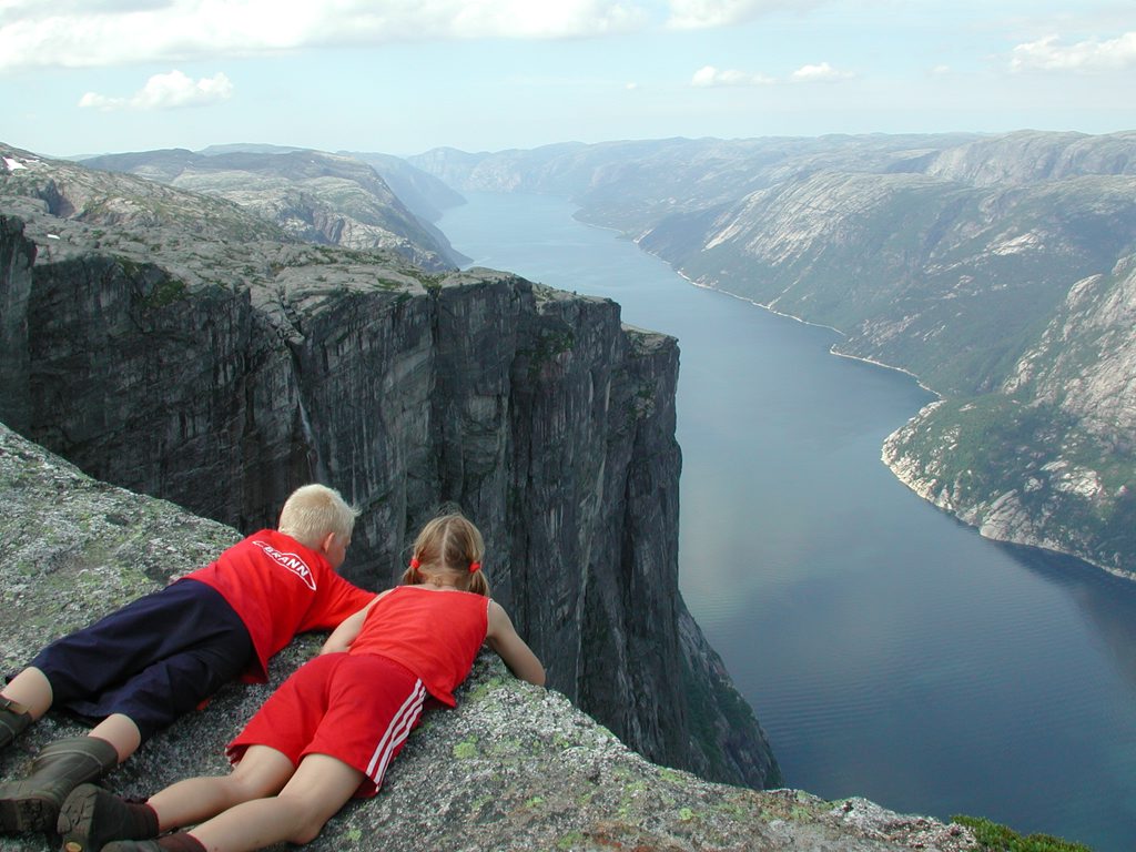
Ryfylke is a traditional district in the northeastern part of Rogaland county, Norway. The district is located northeast of the city of Stavanger and east of the city of Haugesund and it encompasses about 60% of the county's area. It includes the mainland located northeast and east of the Boknafjorden and east of the Høgsfjorden. It also includes the islands located on the south side of the Boknafjorden. To the east, Ryfylke borders the districts of Setesdal and Sirdal, to the south is Jæren, and to the west is Haugalandet. Ryfylke is one of the 15 districts in Western Norway. Ryfylke comprises the contemporary municipalities of Sauda, Suldal, Hjelmeland, Strand, Kvitsøy, the eastern island portion of Stavanger, and the Forsand part of Sandnes. There are no large cities in Ryfylke, but there are two major towns, Sauda and Jørpeland. Scenic attractions include the Lysefjord with the mountain Preikestolen ("Pulpit Rock") and the mountain Kjerag. The landscape of Ryf ... [...More Info...] [...Related Items...] OR: [Wikipedia] [Google] [Baidu] |
Strand, Norway
Strand is a municipality in Rogaland county, Norway. It is located in the traditional district of Ryfylke. The administrative centre of the municipality is the town of Jørpeland. The municipality lies across the fjord from the city of Stavanger. The Ryfast tunnel system connects Stavanger and Strand by a very long undersea tunnel. The villages of Sørskår and Fiskå are located in northern Strand, on the southern shore of the Årdalsfjorden. This area of Strand produces fruit, vegetables, and dairy products. The Fiskå Mølle (Fiskå Mill) is located in Fiskå. The larger village of Tau is located on the western coast of Strand. It is a transportation hub with ferry connections to the city of Stavanger and bus services to nearby Hjelmelandsvågen and deeper into the Ryfylke district. About southeast of Tau is the municipal center of Jørpeland. This town is the largest settlement in Strand with about 7,000 people. The municipality is the 278th largest by area out of ... [...More Info...] [...Related Items...] OR: [Wikipedia] [Google] [Baidu] |
Suldal
Suldal is a municipality in the northeast corner of Rogaland county, Norway. It is located in the traditional district of Ryfylke. Since 1965, the administrative centre of Suldal is the village of Sand i Ryfylke (prior to that it was the village of Suldalsosen). Other villages in Suldal include Haugsland, Jelsa, Marvik, Nesflaten, and Suldalsosen. The municipality is the 46th largest by area out of the 356 municipalities in Norway. Suldal is the 208th most populous municipality in Norway with a population of 3,784. The municipality's population density is and its population has decreased by 1.6% over the previous 10-year period. General information The parish of ''Suledal'' was established as a municipality on 1 January 1838 (see formannskapsdistrikt law). In 1842, the northern district of the municipality (population: 1,584) was separated to become the new municipality of Søvde. This left Suldal with 2,030 residents. During the 1960s, there were many municipal mergers ... [...More Info...] [...Related Items...] OR: [Wikipedia] [Google] [Baidu] |
Sauda (town)
Sauda is a town in Sauda municipality in Rogaland county, Norway. The town, which is also the administrative centre of the municipality, is located in a river valley at the northern end of the Saudafjorden. The small suburb of Saudasjøen lies about west of the town centre. A large part of the industrial harbour area of Sauda is built on reclaimed land that was once underwater in the fjord. Sauda received city status in 1998. The town has a population (2019) of 4,174 and a population density of . Sauda is the largest settlement in the municipality as well as the only urban area The newspaper '' Ryfylke'' has been published in Sauda since 1926. The town has four churches: Sauda Church and Solbrekk Chapel in the town centre, Saudasjøen Chapel in the western suburb of Saudasjøen, and Hellandsbygd Chapel a few miles north of Sauda. There is also a high school in the town as well as the ''Ryfylkesmuseet'' ( Ryfylke museum). History Sauda was originally (as with many Norw ... [...More Info...] [...Related Items...] OR: [Wikipedia] [Google] [Baidu] |
Forsand
Forsand is a former municipality in Rogaland county, Norway. The municipality existed from 1871 until 2020 when it was merged into Sandnes municipality. It was located in the traditional district of Ryfylke. The administrative centre of the municipality was the village of Forsand. Other villages in the municipality included Lysebotn, Øvre Espedal, Oanes, Kolabygda, and Fløyrli. Forsand municipality surrounded the famous Lysefjorden and it was located on the east side of the Høgsfjorden. In 1999, evidence of a population here dating back to around 7500 BC was located. Prior to its dissolution in 2020, it was one of the largest municipalities within the county of Rogaland in terms of area, and one of the smallest in terms of population. The municipality was the 141st largest by area out of the 422 municipalities in Norway. Forsand was the 376th most populous municipality in Norway with a population of 1,245. The municipality's population density was and its p ... [...More Info...] [...Related Items...] OR: [Wikipedia] [Google] [Baidu] |
Hjelmeland
is a municipality in Rogaland county, Norway. It is located in the traditional district of Ryfylke. The administrative centre of the municipality is the village of Hjelmelandsvågen. Other villages in the municipality include Fister, Årdal, and Jøsenfjorden. Hjelmeland is known for its fruit (apples, pears, plums, cherries and strawberries) and fish production. Salmon has been important for the fish industry in Hjelmeland for a couple of decades, but white fish such as cod and halibut has increased its value in the latter years. The municipality is the 105th largest by area out of the 356 municipalities in Norway. Hjelmeland is the 250th most populous municipality in Norway with a population of 2,534. The municipality's population density is and its population has decreased by 9.7% over the previous 10-year period. General information Hjelmeland was established as a municipality on 1 January 1838 (see formannskapsdistrikt law). In 1859, Hjelmeland municipality wa ... [...More Info...] [...Related Items...] OR: [Wikipedia] [Google] [Baidu] |
Rogaland
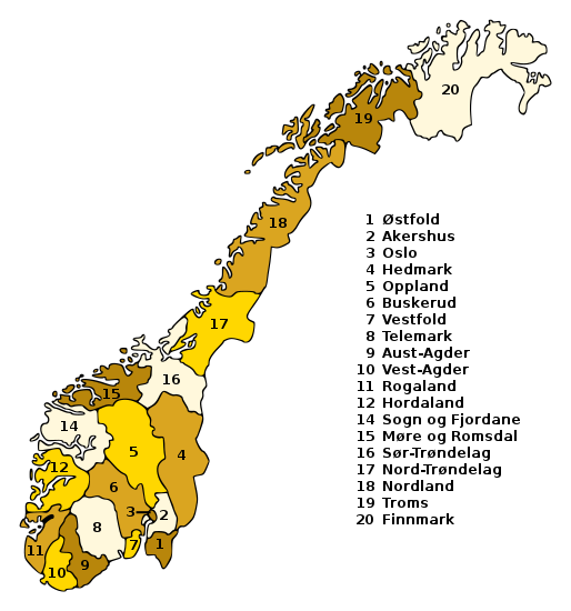
Rogaland () is a county in Western Norway, bordering the North Sea to the west and the counties of Vestland to the north, Vestfold og Telemark to the east and Agder to the east and southeast. In 2020, it had a population of 479,892. The administrative centre of the county is the city of Stavanger, which is one of the largest cities in Norway. Rogaland is the centre of the Norwegian petroleum industry. In 2016, Rogaland had an unemployment rate of 4.9%, one of the highest in Norway. In 2015, Rogaland had a fertility rate of 1.78 children per woman, which is the highest in the country. The Diocese of Stavanger for the Church of Norway includes all of Rogaland county. Etymology ''Rogaland'' is the region's Old Norse name, which was revived in modern times. During Denmark's rule of Norway until the year 1814, the county was named ''Stavanger amt'', after the large city of Stavanger. The first element is the plural genitive case of ''rygir'' which is probably referring to th ... [...More Info...] [...Related Items...] OR: [Wikipedia] [Google] [Baidu] |
Stavanger
Stavanger (, , American English, US usually , ) is a city and municipalities of Norway, municipality in Norway. It is the fourth largest city and third largest metropolitan area in Norway (through conurbation with neighboring Sandnes) and the administrative center of Rogaland county. The municipality is the fourth most populous in Norway. Located on the Stavanger Peninsula in southwest Norway, Stavanger counts its official founding year as 1125, the year the Stavanger Cathedral was completed. Stavanger's core is to a large degree 18th- and 19th-century wooden houses that are protected and considered part of the city's cultural heritage. This has caused the town center and inner city to retain a small-town character with an unusually high ratio of detached houses, and has contributed significantly to spreading the city's population growth to outlying parts of Greater Stavanger. The city's population rapidly grew in the late 20th century due to its oil industry. Stavanger is known ... [...More Info...] [...Related Items...] OR: [Wikipedia] [Google] [Baidu] |
Preikestolen
Preikestolen or Prekestolen ( en, 'The Pulpit Rock', 'Pulpit', or 'Preacher's Chair') is a tourist attraction in the municipality of Strand in Rogaland county, Norway. Preikestolen is a steep cliff which rises above Lysefjorden. Atop the cliff, there is an almost flat top of approximately . Preikestolen is located near the Western part of the fjord, and on its North side. Tourism at the site has been increasing in the early 21st century, with between 150,000 and 200,000 visitors in 2012, making it one of the most visited natural tourist attractions in Norway. BASE jumpers often leap from the cliff. Due to its increased popularity, the most used path to the site (an long hike) was improved by Nepalese Sherpas in 2013. Name The old local name of the site is ; en, (woodworker's) Plane's Tooth. The name ''Prekestolen'' (without the ''i'') was coined around the year 1900 when the local tourist organisation, , wanted to promote the site for trekking. The "i" was added later to co ... [...More Info...] [...Related Items...] OR: [Wikipedia] [Google] [Baidu] |
Lysefjord
Lysefjord or Lysefjorden is a fjord located in the Ryfylke area in Rogaland county in southwestern Norway. The long fjord lies in the municipalities of Strand and Sandnes, about east of the city of Stavanger. The name means ''light fjord'', and is said to be derived from the lightly coloured granite rocks along its sides. It is particularly well known for the huge Preikestolen cliff overlooking the fjord, which is a major tourist destination for the region. The fairly isolated village of Lysebotn lies at the eastern end of the fjord and the villages of Forsand and Oanes both lie at the western end of the fjord near the Lysefjord Bridge, the only crossing of the fjord. Geology The fjord was carved by the action of glaciers in the ice ages and was flooded by the sea when the later glaciers retreated. The geology of Lysefjorden was thoroughly investigated and described by Professor Bjørn G. Andersen in his Master's thesis (1954) ''(On the glacial retreat in the area betwee ... [...More Info...] [...Related Items...] OR: [Wikipedia] [Google] [Baidu] |
Sauda
Sauda ''()'' is a municipality in Rogaland county, Norway. The administrative centre of the municipality is the town of Sauda, where most of the population lives. Other villages in the municipality include Saudasjøen and Amdal. Despite being in the northern part of the region of Ryfylke, Sauda participates in the Haugalandet Council and is under the jurisdiction of the Haugaland og Sunnhordland District Court. The municipality is the 197th largest by area out of the 356 municipalities in Norway. Sauda is the 190th most populous municipality in Norway with a population of 4,525. The municipality's population density is and its population has decreased by 4.8% over the previous 10-year period. The town of Sauda is the fifth largest town in Rogaland county with 4,254 inhabitants (2016), and the city center is home to Northern Europe's largest melting plant, Eramet Norway AS. The municipality is situated in the mountain valleys surrounding the Saudafjorden. General informat ... [...More Info...] [...Related Items...] OR: [Wikipedia] [Google] [Baidu] |
Counties Of Norway
Norway is divided into 11 administrative regions, called counties (singular no, fylke, plural nb, fylker; nn, fylke from Old Norse: ''fylki'' from the word "folk", sme, fylka, sma, fylhke, smj, fylkka, fkv, fylkki) which until 1918 were known as '' amter''. The counties form the first-level administrative divisions of Norway and are further subdivided into 356 municipalities (''kommune'', pl. ''kommuner'' / ''kommunar''). The island territories of Svalbard and Jan Mayen are outside the county division and ruled directly at the national level. The capital Oslo is both a county and a municipality. In 2017, the Solberg government decided to abolish some of the counties and to merge them with other counties to form larger ones, reducing the number of counties from 19 to 11, which was implemented on 1 January 2020. This sparked popular opposition, with some calling for the reform to be reversed. The Storting voted to partly undo the reform on 14 June 2022, ... [...More Info...] [...Related Items...] OR: [Wikipedia] [Google] [Baidu] |
Western Norway
Western Norway ( nb, Vestlandet, Vest-Norge; nn, Vest-Noreg) is the region along the Atlantic coast of southern Norway. It consists of the counties Rogaland, Vestland, and Møre og Romsdal. The region has no official or political-administrative function. The region has a population of approximately 1.4 million people. The largest city is Bergen and the second-largest is Stavanger. Historically the regions of Agder, Vest-Telemark, Hallingdal, Valdres, and northern parts of Gudbrandsdal have been included in Western Norway. Western Norway, as well as other parts of historical regions of Norway, shares a common history with Denmark, the Faroe Islands and Iceland and to a lesser extent the Netherlands and Britain. For example, the Icelandic horse is a close relative of the Fjord horse and both the Faroese and Icelandic languages are based on the Old West Norse. In early Norse times, people from Western Norway became settlers at the Western Isles in the Northern Atla ... [...More Info...] [...Related Items...] OR: [Wikipedia] [Google] [Baidu] |

.jpg)


