|
Reichenbachtal
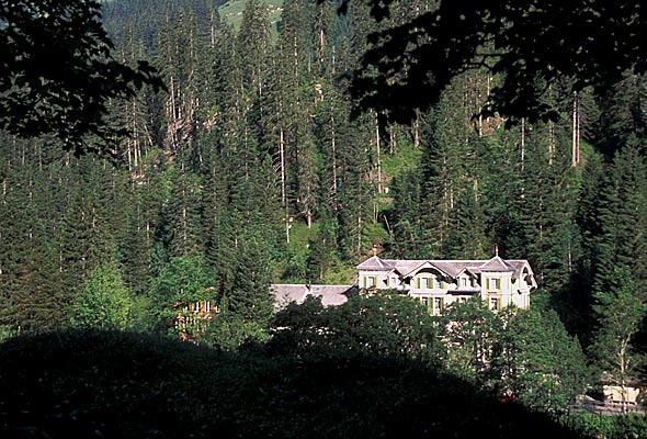
Reichenbachtal is an Alpine valley in Oberhasli, canton of Berne, Switzerland. It is situated within the municipality of Schattenhalb, connecting Meiringen with the Grosse Scheidegg pass towards Grindelwald. Its water, the Rychenbach, forms the Reichenbach Fall before joining the Aare at Meiringen. Rosenlaui is the highest settlement in the valley, situated approximately halfway up, at 1,328 m above sea level. The valley is also known as ''Rosenlauital'' after the settlement. Rosenlaui hotel is among the oldest in the region, bearing testimony to the early boom of tourism in Switzerland in the mid 19th century. On the eastern side of the valley rise the Wetterhorn (3,692 m), the Engelhörner (2,782 m), the Wellhorn (3,191 m), besides the Rosenlaui Glacier. Also east of the valley is the Rosenlouwi Gorge, a deep and narrow gorge formed by the meltwater of the Rosenlaui Glacier, accessible by a 500 m footpath. Further up the valley lies Schwarzwaldalp, marking the end of the pu ... [...More Info...] [...Related Items...] OR: [Wikipedia] [Google] [Baidu] |
Oberhasli
The Oberhasli is a historical '' Landvogtei'' or ''Talschaft'' in the Bernese Highlands, Switzerland, bordering on the cantons of Obwalden (OW), Nidwalden (NW), Uri (UR) and Wallis (VS). From 1833 to 2009, Oberhasli was incorporated as the Oberhasli district, the easternmost of the 26 districts of the canton of Bern, bordering the district of Interlaken to the west. Since 2010, Oberhasli and Interlaken have been administratively united as the administrative district Interlaken-Oberhasli. The local dialect is of the Highest Alemannic variety. With its area of 551 km², it is larger than the canton of Basel-Landschaft. It consists of the six municipalities of Gadmen, Guttannen, Hasliberg, Innertkirchen, Meiringen and Schattenhalb, with a total population of just below 8,000, corresponding to a population density of less than 15/km2 (compared to a Swiss average of 181/km2), due to a significant portion of the area of Oberhasli being uninhabitable High Alps. Haslital is u ... [...More Info...] [...Related Items...] OR: [Wikipedia] [Google] [Baidu] |
Schattenhalb
Schattenhalb is a municipality in the Interlaken-Oberhasli administrative district in the canton of Bern in Switzerland. The municipality includes the settlements of Willigen, Geissholz, Falcheren and Lüögen. History The municipality was created in 1834 from the cooperative farms ('' Bäuerten'') of "Willigen," "Geissholz," "Falchern" and "Lugen." The name Schattenhalb ("Shadow-half") refers to the shady face of the mountainside south of Meiringen. The oldest traces of settlements in the area are scattered Bronze Age ax and spear heads and a Roman era coin hoard. By the Middle Ages the scattered Bäuerten of Schattenhalb were part of the parish of Meiringen and the Vogtei of Hasli. In 1334 the entire Vogtei was acquired by the city of Bern. Traditionally the villagers raised cattle and horses in seasonal alpine meadows and then sold the livestock and cheese to traders. During the 18th and 19th century authors, such as Charles Victor de Bonstetten and Jakob Samuel W ... [...More Info...] [...Related Items...] OR: [Wikipedia] [Google] [Baidu] |
Valleys Of The Alps
The main valleys of the Alps, orographically by drainage basin. Rhine basin (North Sea) High Rhine *Aare **Limmat ***Linth (Glarus) **** Lake Walen ***** Seeztal **** Klöntal **** Sernftal **Reuss ***Lake Lucerne **** Sarner Aa ( Brünig Pass connects to the Aare basin) **** Muota *** Schächental, Klausen Pass connects to Glarus *** Urseren *** Susten Pass connects to the Gadmertal *** Furka Pass connects to the Goms ** Saane/Sarine ***Sense ** Gürbetal **Lake Thun, Bernese Oberland *** Kander **** Simmental ***** Diemtigental (Chirel, Fildrich (Narebach, Senggibach, Gurbsbach)) **** Suldtal **** Kiental **** Engstligental ****Kandertal ***, Habkern *** Brienzersee, Interlaken ****Lütschine ***** Saxettal ***** Schwarze Lütschine, Lütschental, Grindelwald, Grosse Scheidegg connects to Reichenbachtal ***** Weisse Lütschine, Lauterbrunnental, Lauterbrunnen ******Sefinental **** Giessbach ****Haslital, Meiringen ***** Reichenbachtal (Rychenbach, Seilibach), Grosse Sch ... [...More Info...] [...Related Items...] OR: [Wikipedia] [Google] [Baidu] |
Reichenbach Fall
The Reichenbach Falls (german: Reichenbachfälle) are a waterfall cascade of seven steps on the stream called Rychenbach in the Bernese Oberland region of Switzerland. They drop over a total height of about . At , the upper falls, known as the Grand Reichenbach Fall (german: Grosser Reichenbachfall), is by far the tallest segment and one of the highest waterfalls in the Alps, and among the forty highest in Switzerland. The Reichenbach loses of height from the top of the falls to the valley floor of the Haslital. Today, a hydroelectric power company harnesses the flow of the Reichenbach Falls during certain times of year, reducing its flow. In popular literature, Sir Arthur Conan Doyle gave the Grand (or Great) Reichenbach Fall as the location of the final physical altercation between his hero Sherlock Holmes and his greatest foe, the criminal Professor Moriarty, in "The Final Problem". Location The falls are located in the lower part of the Reichenbachtal, on the Rychenbach, ... [...More Info...] [...Related Items...] OR: [Wikipedia] [Google] [Baidu] |
Wetterhorn
The Wetterhorn (3,692 m) is a peak in the Swiss Alps towering above the village of Grindelwald. Formerly known as Hasle Jungfrau, it is one of three summits on a mountain named the "Wetterhörner", the highest of which is the Mittelhorn (3,704 m) and the lowest and most distant the Rosenhorn (3,689 m). The latter peaks are mostly hidden from view from Grindelwald. The Grosse Scheidegg Pass crosses the col to the north, between the Wetterhorn and the Schwarzhorn. Ascents The Wetterhorn summit was first reached on August 31, 1844, by the Grindelwald guides Hans Jaun and Melchior Bannholzer, three days after they had co-guided a large party organized by the geologist Édouard Desor to the first ascent of the Rosenhorn. The Mittelhorn was first summitted on 9 July 1845 by the same guides, this time accompanied by a third, Kaspar Abplanalp, and by British climber Stanhope Templeman Speer. The son of a Scottish physician, Speer lived in Interlaken, Switzerland. A September 18 ... [...More Info...] [...Related Items...] OR: [Wikipedia] [Google] [Baidu] |
Engelhörner 10
The Grosses Engelhorn is a mountain of the Bernese Alps, located west of Innertkirchen in the Bernese Oberland The Bernese Oberland ( en, Bernese Highlands, german: Berner Oberland; gsw, Bärner Oberland; french: Oberland bernois), the highest and southernmost part of the canton of Bern, is one of the canton's five administrative regions (in which context .... It is one of the highest summits of the ''Engelhörner'', the chain between the Reichenbachtal and the Urbachtal. References External links Grosses Engelhorn on Hikr Bernese Alps Mountains of the Alps Mountains of Switzerland Oberhasli Mountains of the canton of Bern Two-thousanders of Switzerland {{Bern-geo-stub ... [...More Info...] [...Related Items...] OR: [Wikipedia] [Google] [Baidu] |
Grosse Scheidegg
The Grosse Scheidegg is a mountain pass in the Bernese Alps of Switzerland, The pass crosses the col between the Schwarzhorn and the Wetterhorn mountains at an elevation of . The pass is traversed by a road connecting the town of Meiringen, at an elevation of , with the village of Grindelwald, at an elevation of . The road is closed to most traffic, but is used by a PostBus Switzerland service from Grindelwald to the summit of the pass, with some buses continuing to Meiringen. Bus services operate between May and October, with between four and ten buses a day depending on time of year and section of the route. Hiking over the pass is popular, and it forms part of the cross-country Alpine Pass Route between Sargans and Montreux. From the Meiringen side, the approach to the pass runs through the valley of the Reichenbach stream above the Reichenbach Falls, best known as the place of the last fight between Holmes and Moriarty. The falls can be visited from the pass road, or by u ... [...More Info...] [...Related Items...] OR: [Wikipedia] [Google] [Baidu] |
Engelhörner
The Grosses Engelhorn is a mountain of the Bernese Alps, located west of Innertkirchen in the Bernese Oberland The Bernese Oberland ( en, Bernese Highlands, german: Berner Oberland; gsw, Bärner Oberland; french: Oberland bernois), the highest and southernmost part of the canton of Bern, is one of the canton's five administrative regions (in which context .... It is one of the highest summits of the ''Engelhörner'', the chain between the Reichenbachtal and the Urbachtal. References External links Grosses Engelhorn on Hikr Bernese Alps Mountains of the Alps Mountains of Switzerland Oberhasli Mountains of the canton of Bern Two-thousanders of Switzerland {{Bern-geo-stub ... [...More Info...] [...Related Items...] OR: [Wikipedia] [Google] [Baidu] |
Aare Basin
The Aare () or Aar () is a tributary of the High Rhine and the longest river that both rises and ends entirely within Switzerland. Its total length from its source to its junction with the Rhine comprises about , during which distance it descends , draining an area of , almost entirely within Switzerland, and accounting for close to half the area of the country, including all of Central Switzerland. There are more than 40 hydroelectric plants along the course of the Aare. The river's name dates to at least the La Tène period, and it is attested as ''Nantaror'' "Aare valley" in the Berne zinc tablet. The name was Latinized as ''Arula''/''Arola''/''Araris''. Course The Aare rises in the great Aargletschers (Aare Glaciers) of the Bernese Alps, in the canton of Bern and west of the Grimsel Pass. The Finsteraargletscher and Lauteraargletscher come together to form the Unteraargletscher (Lower Aar Glacier), which is the main source of water for the Grimselsee (Lake of ... [...More Info...] [...Related Items...] OR: [Wikipedia] [Google] [Baidu] |
PostBus Switzerland
PostAuto Switzerland, PostBus Ltd. (known as in Swiss Standard German (), in Swiss French (), in Swiss Italian (), and in Romansh () is a subsidiary company of the Swiss Post, which provides regional and rural bus services throughout Switzerland, and also in France, Germany, and Liechtenstein. The Swiss PostAuto service evolved as a motorized successor to the stagecoaches that previously carried passengers and mail in Switzerland, with the Swiss postal service providing postbus services carrying both passengers and mail. Although this combination had been self-evident in the past, the needs of each diverged towards the end of the twentieth century, when the conveyance of parcels was progressively separated from public transportation. This split became official with the conversion of PostAuto into a separate subsidiary of the Swiss Post in February 2005. The buses operated by PostAuto are a Swiss icon, with a distinctive yellow livery and three-tone horn. The compan ... [...More Info...] [...Related Items...] OR: [Wikipedia] [Google] [Baidu] |


