|
Roads In Victoria
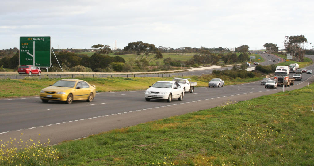
Victoria has the highest density of roads of any state in Australia. Unlike Australia's other mainland states, which have vast areas with virtually no residents, Victoria has population centres spread out over most of the state, with only the far north-west and the Victorian Alps without significant settlements. Population centres are linked by high quality highways and freeways. The state capital, Melbourne, has the most extensive freeway network of any city in Australia. VicRoads is responsible for road planning, motor vehicle registration, and driver licensing in Victoria. The Victorian government has set up a framework for the integration of transport facilities in the State. Two private companies operate toll roads in the state. Roads in Victoria are shared by a multitude of modes of transport, ranging from trucks to bicycles, public buses, trams, taxis as well as private cars of all types. Road safety is a primary concern of road authorities, including the police and go ... [...More Info...] [...Related Items...] OR: [Wikipedia] [Google] [Baidu] |
Spencer Street
Spencer Street is a major street and thoroughfare in the Melbourne central business district, Victoria, Australia. The street was gazetted in 1837 as the westernmost boundary of the Hoddle Grid. Spencer Street is named for John Spencer, former Chancellor of the Exchequer in the United Kingdom. As the 3rd Earl of Spencer, he was the 2nd great uncle of The Princess of Wales, Diana Spencer. John's younger brother, Frederick, became the 4th Earl of Spencer on his brother's death. Frederick was Diana's 2nd great grandfather. On the 15th of April 1983, the Prince and Princess of Wales on their royal tour, departed Spencer Street Station for Ballarat, returning later that afternoon. Location Running roughly north–south, Spencer Street forms the western edge of the original Hoddle Grid. To the north Spencer Street becomes Dynon Road, whilst to the south it becomes Clarendon Street after crossing the Spencer Street Bridge over the Yarra River. Spencer Street denotes the boundary ... [...More Info...] [...Related Items...] OR: [Wikipedia] [Google] [Baidu] |
Cain II Ministry
The Cain II Ministry was the 62nd ministry of the Government of Victoria. It was led by the then Premier of Victoria, John Cain Jr., of the Australian Labor Party The Australian Labor Party (ALP), also known as the Labor Party or simply Labor, is the major Centre-left politics, centre-left List of political parties in Australia, political party in Australia and one of two Major party, major parties in Po .... The ministry was sworn in on April 8, 1982, and remained a single ministry through three parliaments until on August 10, 1990. The ministry dissolved upon Cain's resignation as Leader of the Labor Party. Ministry 13 October 1988 – 10 August 1990 14 March – 13 October 1988 At the beginning of this ministry, titles "Minister of" were standardised to "Minister for". 8 April 1982 – 14 March 1985 Reference list {{Victorian ministries 1982 establishments in Australia Cabinets established in 1982 Cabinets disestablished in 1990 Australian ... [...More Info...] [...Related Items...] OR: [Wikipedia] [Google] [Baidu] |
Monash Freeway
The Monash Freeway is a major urban freeway in Victoria (Australia), Victoria, Australia, linking Melbourne's CBD to its south-eastern suburbs and beyond to the Gippsland region. It carries up to 180,000 vehicles per day and is one of Australia's busiest freeways. The entire stretch of the Monash Freeway bears the designation M1. The freeway is named in honour of General (Australia), General Sir John Monash, an esteemed Australian military commander for the Allies of World War I, allies during World War I. History The Monash Freeway is an amalgamation of two initially separate freeways: the Mulgrave Freeway (initially designated Freeway Route 81) linking Warrigal Road, Chadstone, Victoria, Chadstone to the Princes Highway in Eumemmerring, Victoria, Eumemmerring; and the South Eastern Freeway (initially designated Metropolitan Route 80, then Freeway Route 80) linking Hoddle Highway, Punt Road, Richmond, Victoria, Richmond and Toorak Road, Hawthorn East, Victoria, Hawthorn East. ... [...More Info...] [...Related Items...] OR: [Wikipedia] [Google] [Baidu] |
Eastern Freeway, Melbourne
The Eastern Freeway is an urban freeway in eastern Melbourne, the state capital of Victoria, Australia. It is one of the most important freeways in terms of commuting to the city, connecting Alexandra Parade and Hoddle Street in the inner suburbs, with EastLink tollway farther east. It consists of between three and six lanes (including the Hard Shoulder Running lane during peak periods) in each direction, also an inbound transit lane reserved for vehicles with two or more occupants during peak hours. It is continually the widest freeway in Melbourne, with 12 lanes altogether near the Hoddle Street and Alexandra Parade end. Route The Eastern Freeway starts at its junction with Hoddle Street, as an eastern continuation of Alexandra Parade, with six lanes eastbound and three lanes westbound. Three more lanes (that provide an exit to Hoddle Street) join the westbound carriageway after it leaves the junction, and after a short distance both directions narrow from six to five ... [...More Info...] [...Related Items...] OR: [Wikipedia] [Google] [Baidu] |
Canberra Times
''The Canberra Times'' is a daily newspaper in Canberra, Australia, which is published by Australian Community Media. It was founded in 1926, and has changed ownership and format several times. History ''The Canberra Times'' was launched in 1926 by Thomas Shakespeare along with his oldest son Arthur Shakespeare and two younger sons Christopher and James. The newspaper's headquarters were originally located in the Civic retail precinct, in Cooyong Street and Mort Street, in blocks bought by Thomas Shakespeare in the first sale of Canberra leases in 1924. The newspaper's first issue was published on 3 September 1926. It was the second paper to be printed in the city, the first being '' The Federal Capital Pioneer''. Between September 1926 and February 1928, the newspaper was a weekly issue. The first daily issue was 28 February 1928. In June 1956, ''The Canberra Times'' converted from broadsheet to tabloid format. Arthur Shakespeare sold the paper to John Fairfax ... [...More Info...] [...Related Items...] OR: [Wikipedia] [Google] [Baidu] |
Carlton Association
The Carlton Association was a community action group that campaigned on behalf of residents of the suburb of Carlton in Melbourne, Australia, between the years 1969 and 1993. The group was involved in protests against some of the most controversial redevelopment plans in the city’s history and was arguably the most politically successful residents’ action group that Melbourne has seen. Beginnings The Association was formed in March 1969 by residents of Carlton and neighbouring Carlton North, in order to mobilise opposition to the Housing Commission of Victoria's (HCV) plans to redevelop large tracts of the two suburbs under its program of ''slum clearance''. The HCV had long considered much of the housing stock of the inner suburbs of Melbourne to be unfit for habitation. The Commission’s modus operandi involved the compulsory acquisition of dwellings in a designated block, the wholesale demolition of these, and construction of high-rise flats of public housing. The ''com ... [...More Info...] [...Related Items...] OR: [Wikipedia] [Google] [Baidu] |
Fitzroy, Victoria
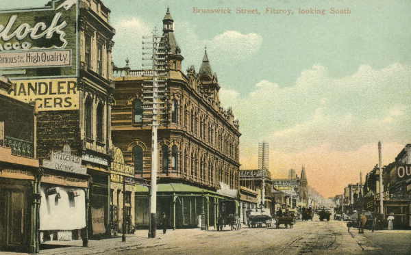
Fitzroy is an inner-city suburb in Melbourne, Victoria, Australia, northeast of the Melbourne central business district, located within the City of Yarra Local government areas of Victoria, local government area. Fitzroy recorded a population of 10,431 at the 2021 Australian census, 2021 census. Planned as Melbourne's first suburb in 1839, it later became one of the city's first areas to gain municipal status, in 1858, then known as Fitz Roy. It occupies Melbourne's smallest and most densely populated area outside the CBD, just 100 Hectare, ha. Fitzroy is known as a cultural hub, particularly for its live music scene and street art, and is the main home of the Melbourne Fringe Festival. Its commercial heart is Brunswick Street, Melbourne, Brunswick Street, one of Melbourne's major retail, culinary, and nightlife strips. Long associated with the working class, Fitzroy has undergone waves of urban renewal and gentrification since the 1980s and today is home to a wide variety of ... [...More Info...] [...Related Items...] OR: [Wikipedia] [Google] [Baidu] |
Collingwood, Victoria
Collingwood is an inner-city suburb in Melbourne, Victoria, Australia, 3km north-east of the Melbourne central business district, located within the City of Yarra Local government areas of Victoria, local government area. Collingwood recorded a population of 9,179 at the 2021 Australian census, 2021 census. The area now known as Collingwood is thought to have been named Yálla-birr-ang by the Wurundjeri people, the original Indigenous Australians, Indigenous inhabitants of the area. Following Colonisation of Australia, colonisation, the suburb was named in 1842 after Cuthbert Collingwood, 1st Baron Collingwood, Baron Collingwood or an early hotel which bore his name. Collingwood is one of the oldest suburbs in Melbourne and is bordered by Smith Street, Melbourne, Smith Street, Alexandra Parade, Hoddle Street, Melbourne, Hoddle Street and Victoria Street, Melbourne, Victoria Parade. Collingwood is notable for its historical buildings, with many nineteenth century dwellings, shop ... [...More Info...] [...Related Items...] OR: [Wikipedia] [Google] [Baidu] |
1969 Melbourne Transportation Plan
The 1969 Melbourne Transportation Plan was a road and rail transport plan for Melbourne, the state capital of Victoria, Australia, instituted by Henry Bolte's state government. Most prominently, the plan recommended the provision of an extensive freeway network, much of which has since been built. Despite the majority of the printed material being devoted to non-car transport, 86 per cent of the projected budget was devoted to roads and parking, with only 14 per cent to other forms of transport. The plan recommended of freeways for metropolitan Melbourne, as well as a number of railways. Of the latter, only the City Underground Loop was constructed. Proposed lines to Doncaster and Monash University (now Clayton Campus), and between Dandenong and Frankston, were never built. The plan was described by J.M. Thompson in ''Great Cities and their Traffic'' as "clearly ... a highway plan, not – as it is called – a comprehensive transport plan", and by historian Graeme Davis ... [...More Info...] [...Related Items...] OR: [Wikipedia] [Google] [Baidu] |
Melbourne Central Business District
The Melbourne central business district (colloquially known as "the City" or "the CBD", and gazetted simply as Melbourne) is the city centre of Melbourne, Victoria, Australia. As of the 2021 census, the CBD had a population of 54,941, and is located primarily within the local government area City of Melbourne, with some parts located in the City of Port Phillip. The central business district is centred on the Hoddle Grid, the oldest part of the city laid out in 1837. It also includes parts of the parallel and perpendicular streets to the north, bounded by Victoria Street and Peel Street; and extends south-east along much of the area immediately surrounding St Kilda Road. The CBD is the core of Greater Melbourne's metropolitan area, and is a major financial centre in Australia and the Asia-Pacific region. It is home to several major attractions in Melbourne, including many of the city's famed lanes and arcades, the distinct blend of contemporary and Victorian architec ... [...More Info...] [...Related Items...] OR: [Wikipedia] [Google] [Baidu] |
Princes Highway
Princes Highway is a major road in Australia, extending from Sydney via Melbourne to Adelaide through the states of New South Wales, Victoria (Australia), Victoria and South Australia. It has a length of (along Highway 1) or via the former alignments of the highway, although these routes are slower and connections to the bypassed sections of the original route are poor in many cases. The highway follows the coastline for most of its length, and thus takes quite an indirect and lengthy route. For example, it is from Sydney to Melbourne on Highway 1 (Australia), Highway 1 as opposed to on the more direct Hume Highway (National Highway (Australia), National Highway 31), and from Melbourne to Adelaide compared to on the Western Highway, Victoria, Western and Dukes Highways (National Highway (Australia), National Highway 8). Because of the rural nature and lower traffic volumes over much of its length, Princes Highway is a more scenic and leisurely route than the main highway ... [...More Info...] [...Related Items...] OR: [Wikipedia] [Google] [Baidu] |


