|
Rhythmites
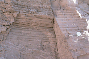
A rhythmite consists of layers of sediment or sedimentary rock which are laid down with an obvious periodicity and regularity. They may be created by annual processes such as seasonally varying deposits reflecting variations in the runoff cycle, by shorter term processes such as tides, or by longer term processes such as periodic floods. Rhythmites serve a significant role in unraveling prehistoric events, providing insights into sea level change, glaciation change, and Earth's orbital variations which serve to answer questions about climate change. Annually-laminated rhythmites Annually-laminated deposits (varves) are rhythmites with annual periodicity: annual layers of sediment or sedimentary rock are laid down through seasonal variations that result from precipitation, or from temperature, which influences precipitation rates and debris loads in runoff. Of the many rhythmites found in the geological record, varves are among the most important and illuminating to studies of pa ... [...More Info...] [...Related Items...] OR: [Wikipedia] [Google] [Baidu] |
Touchet Formation
The Touchet Formation or Touchet beds consist of well-bedded, coarse to fine sand and silt which overlays local bedrock composed of Neogene basalt of the Columbia River Basalt Group in south-central Washington and north-central Oregon. The beds consist of more than 40 to 62 distinct rhythmites – horizontal layers of sediment, each clearly demarcated from the layer below. These Touchet beds are often covered by windblown loess which were deposited later; the number of layers varies with location. The beds vary in thickness from at lower elevations where a number of layers can be found to a few extremely thin layers at the maximum elevation where they are observed (). The Touchet beds are one element in a chain of evidence which helped identify and define the progression of the Missoula Floods, which occurred around 18,400 to 15,700 calendar years ago. During the floods, flow through the Wallula Gap was slow enough such that water pooled in a temporary lake, Lake Lewis. Lak ... [...More Info...] [...Related Items...] OR: [Wikipedia] [Google] [Baidu] |
Neap Tide
Tides are the rise and fall of sea levels caused by the combined effects of the gravitational forces exerted by the Moon (and to a much lesser extent, the Sun) and are also caused by the Earth and Moon orbiting one another. Tide tables can be used for any given locale to find the predicted times and amplitude (or "tidal range"). The predictions are influenced by many factors including the alignment of the Sun and Moon, the phase and amplitude of the tide (pattern of tides in the deep ocean), the amphidromic systems of the oceans, and the shape of the coastline and near-shore bathymetry (see ''Timing''). They are however only predictions, the actual time and height of the tide is affected by wind and atmospheric pressure. Many shorelines experience semi-diurnal tides—two nearly equal high and low tides each day. Other locations have a diurnal tide—one high and low tide each day. A "mixed tide"—two uneven magnitude tides a day—is a third regular category. Tides v ... [...More Info...] [...Related Items...] OR: [Wikipedia] [Google] [Baidu] |
Spring Tide
Tides are the rise and fall of sea levels caused by the combined effects of the gravitational forces exerted by the Moon (and to a much lesser extent, the Sun) and are also caused by the Earth and Moon orbiting one another. Tide tables can be used for any given locale to find the predicted times and amplitude (or " tidal range"). The predictions are influenced by many factors including the alignment of the Sun and Moon, the phase and amplitude of the tide (pattern of tides in the deep ocean), the amphidromic systems of the oceans, and the shape of the coastline and near-shore bathymetry (see '' Timing''). They are however only predictions, the actual time and height of the tide is affected by wind and atmospheric pressure. Many shorelines experience semi-diurnal tides—two nearly equal high and low tides each day. Other locations have a diurnal tide—one high and low tide each day. A "mixed tide"—two uneven magnitude tides a day—is a third regular category. ... [...More Info...] [...Related Items...] OR: [Wikipedia] [Google] [Baidu] |
Big Cottonwood Canyon
Big Cottonwood Canyon is a canyon in the Wasatch Range southeast of Salt Lake City in the U.S. state of Utah. The -long canyon provides hiking, biking, picnicking, rock-climbing, camping, and fishing in the summer. Its two ski resorts, Brighton and Solitude, are popular among skiers and snowboarders. The canyon is accessed by The Big Cottonwood Canyon Scenic Byway (SR-190), which runs its length to Guardsman Pass at the top of the canyon, allowing travel to Park City in the summer months. Hiking to the canyon's mountain lakes is popular, with many trails leading to lakes such as Mary, Martha, and Katherine. The canyon's most popular hiking trail leads to Lakes Blanche, Florence and Lillian. The trail is long and a strenuous hike. Since the canyon was formed by Big Cottonwood Creek, the V-shaped canyon has many impressive rock forms. The canyon is also a frequent destination for Utah Native Plant Society wildflower walks and for University of Utah botanical field trips. T ... [...More Info...] [...Related Items...] OR: [Wikipedia] [Google] [Baidu] |
Incremental Dating
Incremental dating techniques allow the construction of year-by-year annual chronologies, which can be temporally fixed (''i.e.,'' linked to the present day and thus calendar or sidereal time) or floating. Archaeologists use tree-ring dating (dendrochronology) to determine the age of old pieces of wood. Trees usually add growth rings on a yearly basis, with the spacing of rings being wider in high growth years and narrower in low growth years. Patterns in tree-ring growth can be used to establish the age of old wood samples, and also give some hints to local climatic conditions. This technique is useful to about 9,000 years ago for samples from the western United States using overlapping tree-ring series from living and dead wood. The Earth's orbital motions (inclination of the Earth's axis on its orbit with respect to the Sun, gyroscopic precession of the Earth's axis every 26,000 years; free precession every 440 days, Free_precession#Precession_of_planetary_orbits, precession of ... [...More Info...] [...Related Items...] OR: [Wikipedia] [Google] [Baidu] |
Dendroclimatology
Dendroclimatology is the science of determining past climates from trees (primarily properties of the annual tree rings). Tree rings are wider when conditions favor growth, narrower when times are difficult. Other properties of the annual rings, such as maximum latewood density (MXD) have been shown to be better proxies than simple ring width. Using tree rings, scientists have estimated many local climates for hundreds to thousands of years previous. By combining multiple tree-ring studies (sometimes with other climate proxy (climate), proxy records), scientists have estimated past regional and global climates. Advantages Tree rings are especially useful as climate proxy (climate), proxies in that they can be well-dated via dendrochronology, i.e. matching of the rings from sample to sample. This allows extension backwards in time using deceased tree samples, even using samples from buildings or from archeological digs. Another advantage of tree rings is that they are clearly de ... [...More Info...] [...Related Items...] OR: [Wikipedia] [Google] [Baidu] |
Dendrochronology
Dendrochronology (or tree-ring dating) is the scientific method of chronological dating, dating tree rings (also called growth rings) to the exact year they were formed in a tree. As well as dating them, this can give data for dendroclimatology, the study of climate and atmospheric conditions during different periods in history from the wood of old trees. Dendrochronology derives from the Ancient Greek (), meaning "tree", (), meaning "time", and (), "the study of". Dendrochronology is useful for determining the precise age of samples, especially those that are too recent for radiocarbon dating, which always produces a range rather than an exact date. However, for a precise date of the death of the tree a full sample to the edge is needed, which most trimmed timber will not provide. It also gives data on the timing of events and rates of change in the environment (most prominently climate) and also in wood found in archaeology or works of art and architecture, such as old pane ... [...More Info...] [...Related Items...] OR: [Wikipedia] [Google] [Baidu] |
Permian Period
The Permian ( ) is a geologic period and System (stratigraphy), stratigraphic system which spans 47 million years, from the end of the Carboniferous Period million years ago (Mya), to the beginning of the Triassic Period 251.902 Mya. It is the sixth and last period of the Paleozoic Era; the following Triassic Period belongs to the Mesozoic Era. The concept of the Permian was introduced in 1841 by geologist Sir Roderick Murchison, who named it after the Perm Governorate, region of Perm in Russia. The Permian witnessed the diversification of the two groups of amniotes, the synapsids and the Sauropsida, sauropsids (reptiles). The world at the time was dominated by the supercontinent Pangaea, which had formed due to the collision of Euramerica and Gondwana during the Carboniferous. Pangaea was surrounded by the superocean Panthalassa. The Carboniferous rainforest collapse left behind vast regions of desert within the continental interior. Amniotes, which could better cope with these ... [...More Info...] [...Related Items...] OR: [Wikipedia] [Google] [Baidu] |
Pennsylvanian Period
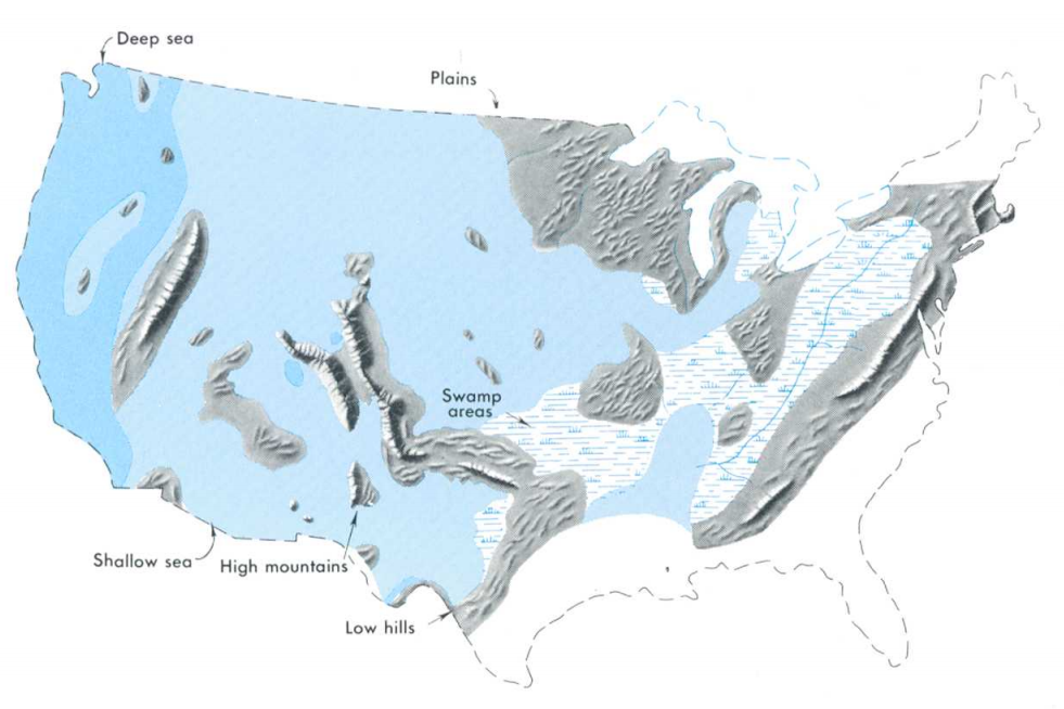
The Pennsylvanian ( , also known as Upper Carboniferous or Late Carboniferous) is, on the ICS geologic timescale, the younger of two subperiods of the Carboniferous Period (or the upper of two subsystems of the Carboniferous System). It lasted from roughly . As with most other geochronologic units, the rock beds that define the Pennsylvanian are well identified, but the exact date of the start and end are uncertain by a few hundred thousand years. The Pennsylvanian is named after the U.S. state of Pennsylvania, where the coal beds of this age are widespread. The division between Pennsylvanian and Mississippian comes from North American stratigraphy. In North America, where the early Carboniferous beds are primarily marine limestones, the Pennsylvanian was in the past treated as a full-fledged geologic period between the Mississippian and the Permian. In parts of Europe, the Mississippian and Pennsylvanian are one more-or-less continuous sequence of lowland continental dep ... [...More Info...] [...Related Items...] OR: [Wikipedia] [Google] [Baidu] |
Precambrian
The Precambrian ( ; or pre-Cambrian, sometimes abbreviated pC, or Cryptozoic) is the earliest part of Earth's history, set before the current Phanerozoic Eon. The Precambrian is so named because it preceded the Cambrian, the first period of the Phanerozoic Eon, which is named after Cambria, the Latinized name for Wales, where rocks from this age were first studied. The Precambrian accounts for 88% of the Earth's geologic time. The Precambrian is an informal unit of geologic time, subdivided into three eons ( Hadean, Archean, Proterozoic) of the geologic time scale. It spans from the formation of Earth about 4.6 billion years ago ( Ga) to the beginning of the Cambrian Period, about million years ago ( Ma), when hard-shelled creatures first appeared in abundance. Overview Relatively little is known about the Precambrian, despite it making up roughly seven-eighths of the Earth's history, and what is known has largely been discovered from the 1960s onwards. The Precambrian ... [...More Info...] [...Related Items...] OR: [Wikipedia] [Google] [Baidu] |


