|
Prehistoric Indonesia
Prehistoric Indonesia is a prehistoric period in the Indonesian archipelago that spanned from the Pleistocene period to about the 4th century CE when the Kutai people produced the earliest known stone inscriptions in Indonesia. Unlike the clear distinction between prehistoric and historical periods in Europe and the Middle East, the division is muddled in Indonesia. This is mostly because Indonesia's geographical conditions as a vast archipelago caused some parts — especially the interiors of distant islands — to be virtually isolated from the rest of the world. West Java and coastal Eastern Borneo, for example, began their historical periods in the early 4th century, but megalithic culture still flourished and script was unknown in the rest of Indonesia, including in Nias, Batak, and Toraja. The Papuans on the Indonesian part of New Guinea island lived virtually in the Stone Age until their first contacts with modern world in the early 20th century. Even today living megalith ... [...More Info...] [...Related Items...] OR: [Wikipedia] [Google] [Baidu] |
Caves In The Maros-Pangkep Karst
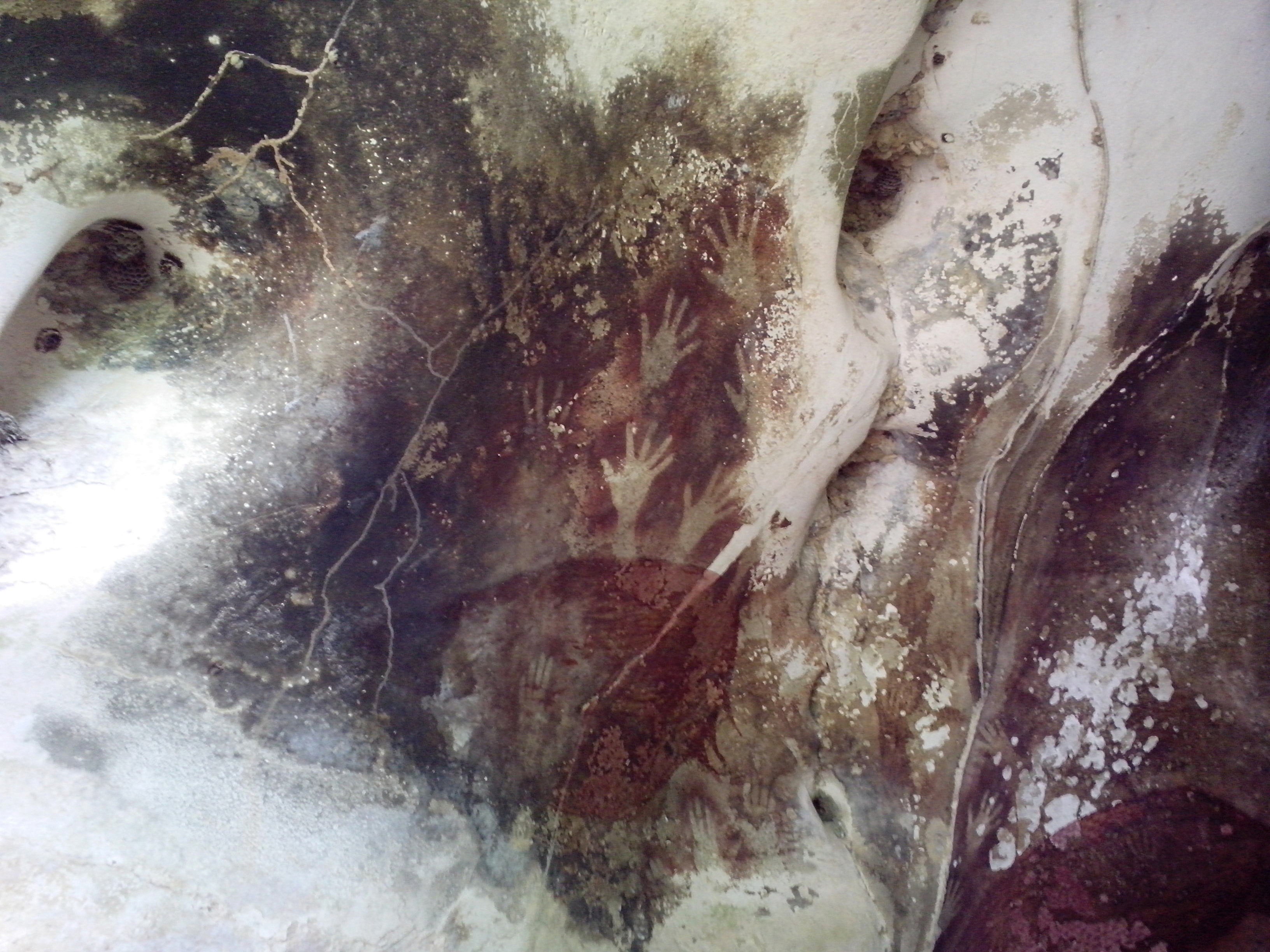
The caves in the Maros-Pangkep karst are situated in South Sulawesi, Indonesia, and contain paintings from the Paleolithic considered to be the earliest figurative art in the world, dated to at least 43,900 years ago. Description The caves in the Maros-Pangkep karst are a cave complex, where prehistoric finds were made. The whole complex is also called "Prehistoric place Leang-Leang" – the name stems from the Makassarese language. The various caves - named Pettae, Jane, Saripa, Jarie, Karrasa, and so on - consist of limestone. They are located from the town of Maros and from the city of Makassar. The entrance to the caves is located above a rice field, accessible by ladder. A hand stencil in the Leang Tempuseng cave was dated to at least 39,900 years old in a 2014 study. The depiction of a babirusa is also located in this cave. It is estimated to be 35,400 years old. The art works were examined with the help of the Uranium-Thorium method of the sintering on the paintings. ... [...More Info...] [...Related Items...] OR: [Wikipedia] [Google] [Baidu] |
Lesser Sunda Islands
The Lesser Sunda Islands or nowadays known as Nusa Tenggara Islands ( id, Kepulauan Nusa Tenggara, formerly ) are an archipelago in Maritime Southeast Asia, north of Australia. Together with the Greater Sunda Islands to the west they make up the Sunda Islands. The islands are part of a volcanic arc, the Sunda Arc, formed by subduction along the Sunda Trench in the Java Sea. A bit more than 20 million people live on the islands. Etymologically, Nusa Tenggara means "Southeast Islands" from the words of ''nusa'' which means 'island' from Old Javanese language and ''tenggara'' means 'southeast'. The main Lesser Sunda Islands are, from west to east: Bali, Lombok, Sumbawa, Flores, Sumba, Savu, Rote, Timor, Atauro, Alor archipelago, Barat Daya Islands, and Tanimbar Islands. Geology The Lesser Sunda Islands consist of two geologically distinct archipelagos.Audley-Charles, M.G. (1987) "Dispersal of Gondwanaland: relevance to evolution of the Angiosperms" ''In'': Whitmo ... [...More Info...] [...Related Items...] OR: [Wikipedia] [Google] [Baidu] |
Aru Islands
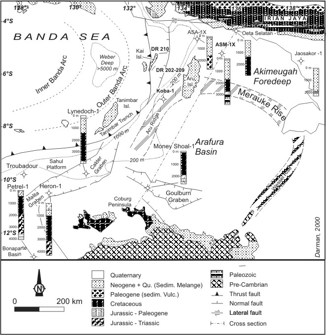
The Aru Islands Regency ( id, Kabupaten Kepulauan Aru) is a group of about 95 low-lying islands in the Maluku Islands of eastern Indonesia. It also forms a regency of Maluku Province, with a land area of . At the 2011 Census the Regency had a population of 84,138;Biro Pusat Statistik, Jakarta, 2011. the 2020 Census produced a total of 102,237. Some sources regard the archipelago as part of Asia, while others regard it as part of Melanesia. Administration At the time of the 2010 Census, the regency was divided into seven districts (''kecamatan''), but subsequently an additional three districts have been created by the splitting of existing districts. The districts are tabulated below with their areas (in km2) and their populations at the 2010 Census and 2020 Census. The table also includes the locations of the district administrative centres, the number of villages (''desa'') in each district, and its postal code. Notes: (a) the 2010 population of Aru Utara Timur Batuley an ... [...More Info...] [...Related Items...] OR: [Wikipedia] [Google] [Baidu] |
Malay Peninsula
The Malay Peninsula ( Malay: ''Semenanjung Tanah Melayu'') is a peninsula in Mainland Southeast Asia. The landmass runs approximately north–south, and at its terminus, it is the southernmost point of the Asian continental mainland. The area contains Peninsular Malaysia, Southern Thailand, and the southernmost tip of Myanmar (Kawthaung). The island country of Singapore also has historical and cultural ties with the region. The indigenous people of the peninsula are the Malays, an Austronesian people. The Titiwangsa Mountains are part of the Tenasserim Hills system and form the backbone of the peninsula and the southernmost section of the central cordillera, which runs from Tibet through the Kra Isthmus, the peninsula's narrowest point, into the Malay Peninsula. The Strait of Malacca separates the Malay Peninsula from the Indonesian island of Sumatra, and the south coast is separated from the island of Singapore by the Straits of Johor. Etymology The Malay term ' ... [...More Info...] [...Related Items...] OR: [Wikipedia] [Google] [Baidu] |
Java Sea
The Java Sea ( id, Laut Jawa, jv, Segara Jawa) is an extensive shallow sea on the Sunda Shelf, between the Indonesian islands of Borneo to the north, Java to the south, Sumatra to the west, and Sulawesi to the east. Karimata Strait to its northwest links it to the South China Sea. It is a part of the western Pacific Ocean. Geography The Java Sea covers the southern section of the Sunda Shelf. A shallow sea, it has a mean depth of . It measures about east-west by north-southGoogleEarth and occupies a total surface area of . It formed as sea levels rose at the end of the last ice age. Its almost uniformly flat bottom, and the presence of drainage channels (traceable to the mouths of island rivers), indicate that the Sunda Shelf was once a stable, dry, low-relief land area ( peneplain) above which were left standing a few monadnocks (granite hills that, due to their resistance to erosion, form the present islands). Extent The International Hydrographic Organization (IHO) ... [...More Info...] [...Related Items...] OR: [Wikipedia] [Google] [Baidu] |
Karimata Strait
The Karimata Strait (alternatively, Carimata or Caramata; id, Selat Karimata) is a wide strait that connects the South China Sea to the Java Sea, separating the Indonesian islands of Belitung to the west and Borneo (Kalimantan) to the east. It is the widest strait between the South China Sea and the Java Sea (other straits include the Bangka and Gaspar straits), but its numerous islands and reefs reduce its navigability. Its weather and current is influenced by the annual southeast and northwest monsoon. It was used as an invasion route by the British fleet in the 1811 Invasion of Java in the Dutch East Indies. More recently, it was the site of the crash of Indonesia AirAsia Flight 8501, and the location of the 2016 edition of Sail Indonesia (dubbed "Sail Karimata Strait"). Geography The strait is about wide from the east coast of Belitung (also known as Billiton) to the west coast of Borneo (Kalimantan). The much narrower Gaspar Strait separates Belitung from Bangka Is ... [...More Info...] [...Related Items...] OR: [Wikipedia] [Google] [Baidu] |
South China Sea
The South China Sea is a marginal sea of the Western Pacific Ocean. It is bounded in the north by the shores of South China (hence the name), in the west by the Indochinese Peninsula, in the east by the islands of Taiwan and northwestern Philippines (mainly Luzon, Mindoro and Palawan), and in the south by Borneo, eastern Sumatra and the Bangka Belitung Islands, encompassing an area of around . It communicates with the East China Sea via the Taiwan Strait, the Philippine Sea via the Luzon Strait, the Sulu Sea via the straits around Palawan (e.g. the Mindoro and Balabac Straits), the Strait of Malacca via the Singapore Strait, and the Java Sea via the Karimata and Bangka Straits. The Gulf of Thailand and the Gulf of Tonkin are also part of the South China Sea. The shallow waters south of the Riau Islands are also known as the Natuna Sea. The South China Sea is a region of tremendous economic and geostrategic importance. One-third of the world's maritime shipp ... [...More Info...] [...Related Items...] OR: [Wikipedia] [Google] [Baidu] |
Malacca Strait
The Strait of Malacca is a narrow stretch of water, 500 mi (800 km) long and from 40 to 155 mi (65–250 km) wide, between the Malay Peninsula (Peninsular Malaysia) to the northeast and the Indonesian island of Sumatra to the southwest, connecting the Andaman Sea (Indian Ocean) and the South China Sea (Pacific Ocean). As the main shipping channel between the Indian and Pacific oceans, it is one of the most important shipping lanes in the world. It is named after the Malacca Sultanate that ruled over the strait between 1400 and 1511, the center of administration of which was located in the modern-day state of Malacca, Malaysia. Extent The International Hydrographic Organization define the limits of the Strait of Malacca as follows: History Early traders from Arabia, Africa, Persia, and Southern India reached Kedah before arriving at Guangzhou. Kedah served as a western port on the Malay Peninsula. They traded glassware, camphor, cotton goods, brocades, ivory, sandalwood, ... [...More Info...] [...Related Items...] OR: [Wikipedia] [Google] [Baidu] |
Sahulland
Geologically, the Sahul Shelf () is a part of the continental shelf of the Australian continent, lying off the northwest coast of mainland Australia. Etymology The name "Sahull" or "Sahoel" appeared on 17th century Dutch maps applied to a submerged sandbank between Australia and Timor. On his 1803 map, Matthew Flinders noted the "Great Sahul Shoal" where Malays came from Makassar to fish for ''trepang'' (sea cucumber). The name Sahul Shelf ( nl, Sahoel-plat) was coined in 1919 by G.A.F. Molengraaff, an authority on the geology of the then Dutch East Indies. Geography The Sahul Shelf proper stretches northwest from Australia much of the way under the Timor Sea towards Timor, ending where the seabed begins descending into the Timor Trough. To the northeast, the Sahul Shelf merges into the Arafura Shelf, which runs from the northern coast of Australia under the Arafura Sea north to New Guinea. The Aru Islands rise from the Arafura Shelf. The Sahul Shelf is sometimes taken to ... [...More Info...] [...Related Items...] OR: [Wikipedia] [Google] [Baidu] |
Sundaland
Sundaland (also called Sundaica or the Sundaic region) is a biogeographical region of South-eastern Asia corresponding to a larger landmass that was exposed throughout the last 2.6 million years during periods when sea levels were lower. It includes Borneo, Java, and Sumatra in Indonesia, and their surrounding small islands, as well as the Malay Peninsula on the Asian mainland. Extent The area of Sundaland encompasses the Sunda Shelf, a tectonically stable extension of Southeast Asia's continental shelf that was exposed during glacial periods of the last 2 million years. The extent of the Sunda Shelf is approximately equal to the 120-meter isobath. In addition to the Malay Peninsula and the islands of Borneo, Java, and Sumatra, it includes the Java Sea, the Gulf of Thailand, and portions of the South China Sea. In total, the area of Sundaland is approximately 1,800,000 km2. The area of exposed land in Sundaland has fluctuated considerably during the past rec ... [...More Info...] [...Related Items...] OR: [Wikipedia] [Google] [Baidu] |
Krakatau
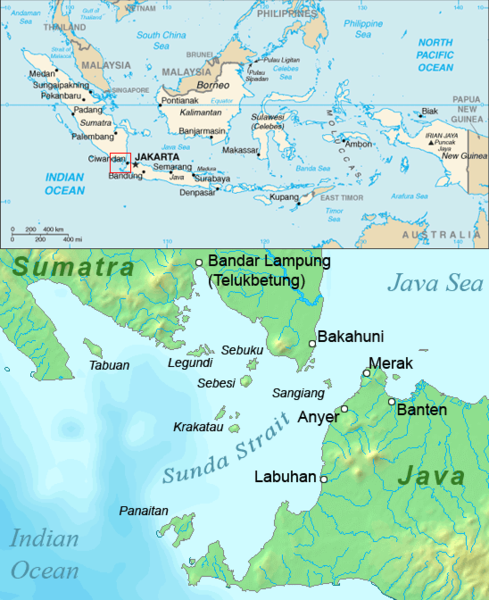
Krakatoa (), also transcribed (), is a caldera in the Sunda Strait between the islands of Java and Sumatra in the Indonesian province of Lampung. The caldera is part of a volcanic island group ( Krakatoa archipelago) comprising four islands. Two, Lang and Verlaten, are remnants of a previous volcanic edifice destroyed in eruptions long before the famous 1883 eruption; another, Rakata, is the remnant of a much larger island destroyed in the 1883 eruption. In 1927, a fourth island, Anak Krakatoa, or "Child of Krakatoa", emerged from the caldera formed in 1883. There has been new eruptive activity since the late 20th century, with a large collapse causing a deadly tsunami in December 2018. Historical significance The most notable eruptions of Krakatoa culminated in a series of massive explosions over 26–27 August 1883, which were among the most violent volcanic events in recorded history. With an estimated Volcanic Explosivity Index (VEI) of 6, the eruption was equival ... [...More Info...] [...Related Items...] OR: [Wikipedia] [Google] [Baidu] |
Mount Tambora
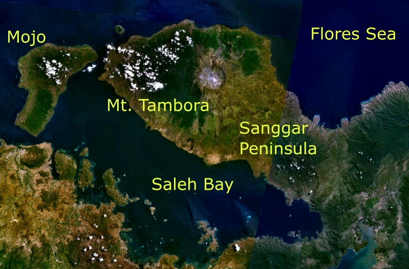
Mount Tambora, or Tomboro, is an active stratovolcano in West Nusa Tenggara, Indonesia. Located on Sumbawa in the Lesser Sunda Islands, it was formed by the active subduction zones beneath it. Before 1815 eruption of Mount Tambora, 1815, its elevation reached more than high, making it one of the tallest peaks in the Indonesian archipelago. Tambora 1815 eruption of Mount Tambora, violently erupted in a series of eruptions beginning 5 April, 1815, culminating in the largest eruption in recorded human history and the largest of the Holocene (10,000 years ago to present). The magma chamber under Tambora had been drained by previous eruptions and underwent several centuries of dormant volcano, dormancy as it refilled. Volcanic activity reached a peak that year, culminating in an explosive eruption. The explosion was heard on Sumatra island, more than away. Heavy volcanic ash rains were observed as far away as Borneo, Sulawesi, Java, and Maluku Islands, Maluku islands, and the maxi ... [...More Info...] [...Related Items...] OR: [Wikipedia] [Google] [Baidu] |


