|
Port Jersey Marine Terminal
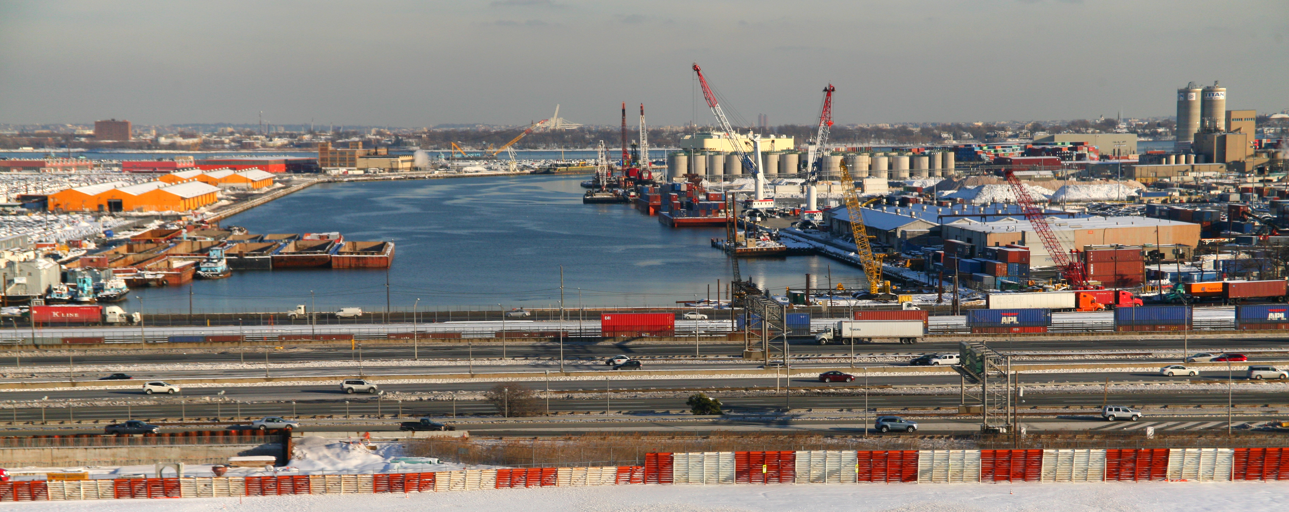
Port Jersey, officially the Port Jersey Port Authority Marine Terminal and referred to as the Port Jersey Marine Terminal, is an intermodal freight transport facility that includes a container terminal located on the Upper New York Bay in the Port of New York and New Jersey. The municipal border of the Hudson County cities of Jersey City and Bayonne runs along the long pier extending into the bay. The facility was created between 1972 and 1976 and acquired by the Port Authority of New York and New Jersey in July 2010. Its major tenant is GCT Bayonne, a post-panamax shipping facility operated by Global Container Terminals. GCT Bayonne has been modernized. In May 2013 a 900 foot (270m) berth extension was completed, increasing the total dock face to 2,700 feet (820m) of contiguous berth, allowing the facility to handle the latest Suez Max vessels. Much of Port Jersey is part of United States Foreign-Trade Zone 49. Most of the area in and around the facility is restricted, thoug ... [...More Info...] [...Related Items...] OR: [Wikipedia] [Google] [Baidu] |
Bayonne, New Jersey
Bayonne ( ) is a city in Hudson County, New Jersey, United States. Located in the Gateway Region, Bayonne is situated on a peninsula located between Newark Bay to the west, the Kill Van Kull to the south, and New York Bay to the east. As of the 2020 United States census, the city's population was 71,686. Bayonne was originally formed as a township on April 1, 1861, from portions of Bergen Township. Bayonne was reincorporated as a city by an act of the New Jersey Legislature on March 10, 1869, replacing Bayonne Township, subject to the results of a referendum held nine days later.Snyder, John P''The Story of New Jersey's Civil Boundaries: 1606-1968'' Bureau of Geology and Topography; Trenton, New Jersey; 1969. p. 146. Accessed February 9, 2012. At the time it was formed, Bayonne included the communities of Bergen Point, Constable Hook, Centreville, Pamrapo and Saltersville. While somewhat diminished, traditional manufacturing, distribution, and maritime activities remai ... [...More Info...] [...Related Items...] OR: [Wikipedia] [Google] [Baidu] |
Bayonne Bridge
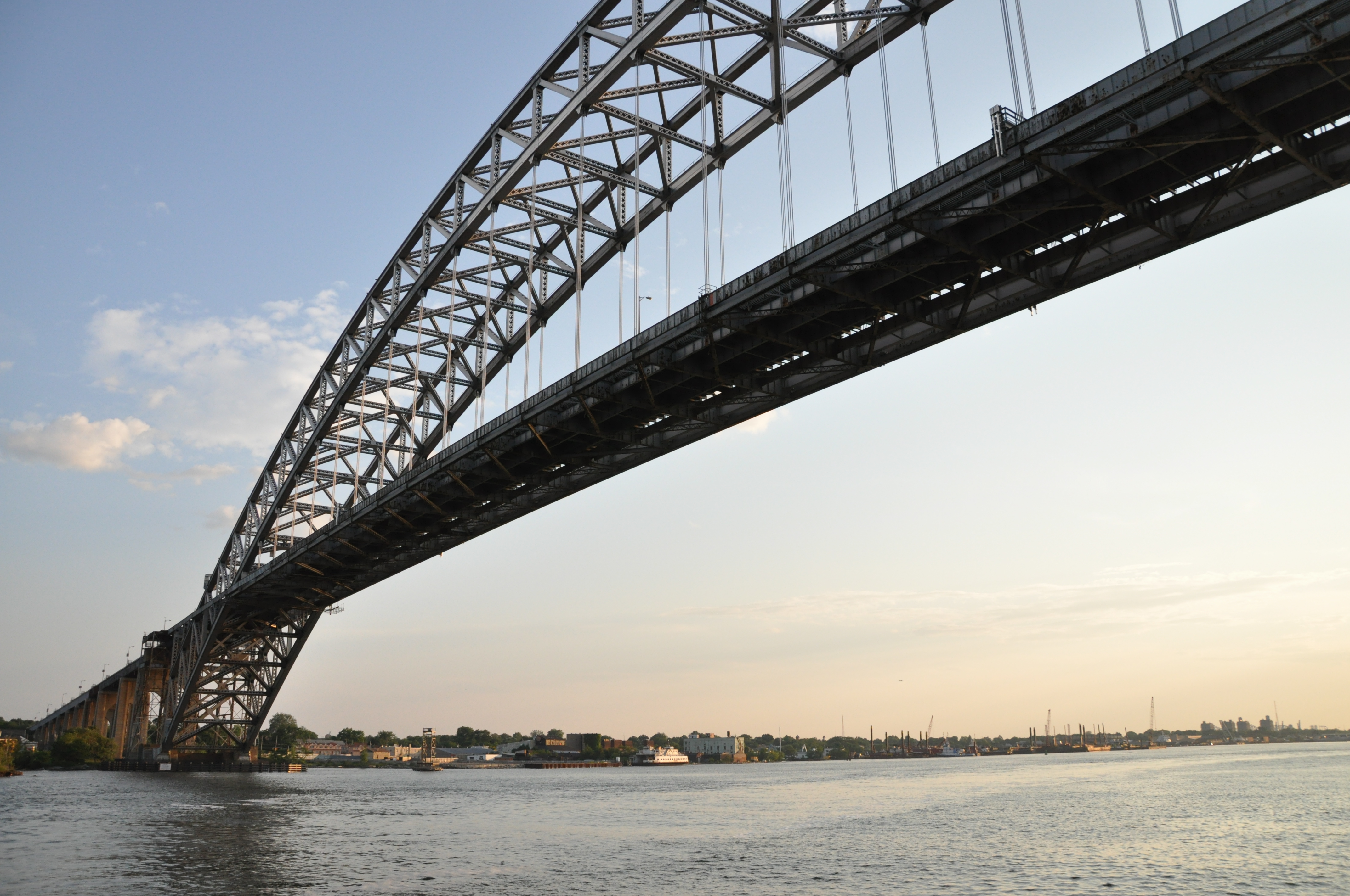
Bayonne Bridge is an arch bridge spanning the Kill Van Kull and connecting Bayonne, New Jersey with Staten Island in New York City. It carries New York State Route 440 (NY 440) and New Jersey Route 440. It is the sixth-longest steel arch bridge in the world, and it was the longest in the world at the time of its completion. The bridge is also one of four connecting New Jersey with Staten Island; the other two roadway bridges are the Goethals Bridge in Elizabeth and Outerbridge Crossing (which also carries Route 440) in Perth Amboy, and the rail-only span is the Arthur Kill Vertical Lift Bridge, all of which cross the Arthur Kill. The original roadway carried two lanes of motor traffic in each direction, as well as a walkway. Completed in 1931, the Bayonne Bridge was built by the Port Authority of New York and New Jersey, which still operates the bridge. It was designed by Swiss master bridge-builder Othmar Ammann and architect Cass Gilbert. A project ... [...More Info...] [...Related Items...] OR: [Wikipedia] [Google] [Baidu] |
New Jersey Route 440
Route 440 is a state highway in New Jersey, United States. It comprises two segments, a freeway in Middlesex County linking Interstate 287 (I-287) and the New Jersey Turnpike (I-95), in Edison to the Outerbridge Crossing in Perth Amboy and a four-lane divided highway in Hudson County running from the Bayonne Bridge in Bayonne to U.S. Route 1/9 Truck (US 1-9 Truck) in Jersey City. These two segments are connected by New York State Route 440 (NY 440), which runs across Staten Island. The freeway portion in Middlesex County is six lanes wide and interchanges with the Garden State Parkway and US 9 in Woodbridge. What is now Route 440 was designated as two different routes in 1927: the Middlesex County portion between Route 4 (now Route 35) and the proposed Outerbridge Crossing was designated Route S4 (a spur of Route 4) while the Hudson County portion was designated as a part of Route 1. In 1953, Route 440 replaced Route S4 as well as Route 1 south of Communipaw ... [...More Info...] [...Related Items...] OR: [Wikipedia] [Google] [Baidu] |
National Docks Secondary
National Docks Secondary is a freight rail line within Conrail's North Jersey Shared Assets Area in Hudson County, New Jersey, used by CSX Transportation. It provides access for the national rail network to maritime, industrial, and distribution facilities at Port Jersey, the Military Ocean Terminal at Bayonne (MOTBY), and Constable Hook as well as carfloat operations at Greenville Yard. The line is an important component in the planned expansion of facilities in the Port of New York and New Jersey. The single track right of way comprises rail beds, viaducts, bridges, and tunnels originally developed at the end of the 19th century by competing railroads. Route The line is used to access the port at the Upper New York Bay, which lies east of those crossing the Northeast Corridor. It runs parallel to the New Jersey Turnpike Newark Bay Extension for most of its length and passes through a cut in the Hudson Palisades. It travels north-south on the east side of Bergen Hill a ... [...More Info...] [...Related Items...] OR: [Wikipedia] [Google] [Baidu] |
ExpressRail
ExpressRail is a network of on- or near-dock rail yards supporting intermodal freight transport at the major container terminals of the Port of New York and New Jersey. The development of dockside trackage and rail yards for transloading has been overseen by the Port Authority of New York and New Jersey, which works in partnership with other public and private stakeholders. As of 2019, four ExpressRail facilities were in operation, with a total built capacity of 1.5 million lifts. Various switching and terminal railroads, including Conrail Shared Assets Operations (CRCX) on the Chemical Coast Secondary connect to the East Coast rail freight network carriers Norfolk Southern (NS) and CSX Transportation (CSX). Overall, the entire Express Rail system handled 433,000 containers in 2012, about 12 percent of the port’s total container volume. In the year period ending October 2014 the total amount of TEUS of Intermodal containers handled at the port included 391,596 rail lifts. S ... [...More Info...] [...Related Items...] OR: [Wikipedia] [Google] [Baidu] |
Bergen Neck
Bergen Neck is the peninsula between the Upper New York Bay and the Newark Bay in the Hudson County, New Jersey municipalities of Bayonne and Jersey City. Its southernmost tip, Bergen Point, is separated from Staten Island by the Kill van Kull, which is crossed by the Bayonne Bridge. It was likely first called so in the 17th century by the first Dutch and English speaking settlers to the region between the bays and northward along the Hudson River and Hackensack River. Though now part of Hudson County, the area was part of Bergen County from its creation in 1683 until Hudson County was created in 1840, and was part of Bergen Township, which lasted until 1862. It was first named Oyster Island by the Dutch, who at first thought it was an island, and for a brief period after the British takeover of New Netherland in 1674 was called Old Hackensack Neck. During the American Revolution British maps showed it as Barren Neck. Bergen Neck is rarely used, occasionally replaced by the ... [...More Info...] [...Related Items...] OR: [Wikipedia] [Google] [Baidu] |
United States Army Corps Of Engineers
, colors = , anniversaries = 16 June (Organization Day) , battles = , battles_label = Wars , website = , commander1 = LTG Scott A. Spellmon , commander1_label = Chief of Engineers and Commanding General of the U.S. Army Corps of Engineers , commander2 = MGbr>Richard J. Heitkamp, commander2_label = Deputy Chief of Engineers and Deputy Commanding General , commander3 = MGKimberly M. Colloton, commander3_label = Deputy Commanding General for Military and International Operations , commander4 = MGbr>William H. Graham, commander4_label = Deputy Commanding General for Civil and Emergency Operations , commander5 = COLbr>James J. Handura, commander5_label = Chief of Staff for the U.S. Army Corps of Eng ... [...More Info...] [...Related Items...] OR: [Wikipedia] [Google] [Baidu] |
New York Metropolitan Area
The New York metropolitan area, also commonly referred to as the Tri-State area, is the largest metropolitan area in the world by urban area, urban landmass, at , and one of the list of most populous metropolitan areas, most populous urban agglomerations in the world. The vast metropolitan area includes New York City, Long Island, the Mid and Lower Hudson Valley in the State of New York; the six largest cities in New Jersey: Newark, New Jersey, Newark, Jersey City, New Jersey, Jersey City, Paterson, New Jersey, Paterson, Elizabeth, New Jersey, Elizabeth, Lakewood, New Jersey, Lakewood, and Edison, New Jersey, Edison, and their vicinities; and six of the seven largest cities in Connecticut: Bridgeport, Connecticut, Bridgeport, Stamford, Connecticut, Stamford, New Haven, Connecticut, New Haven, Waterbury, Connecticut, Waterbury, Norwalk, Connecticut, Norwalk, and Danbury, Connecticut, Danbury, and the vicinities of these cities. The New York metropolitan area comprises the geograp ... [...More Info...] [...Related Items...] OR: [Wikipedia] [Google] [Baidu] |
Cape Liberty Cruise Port
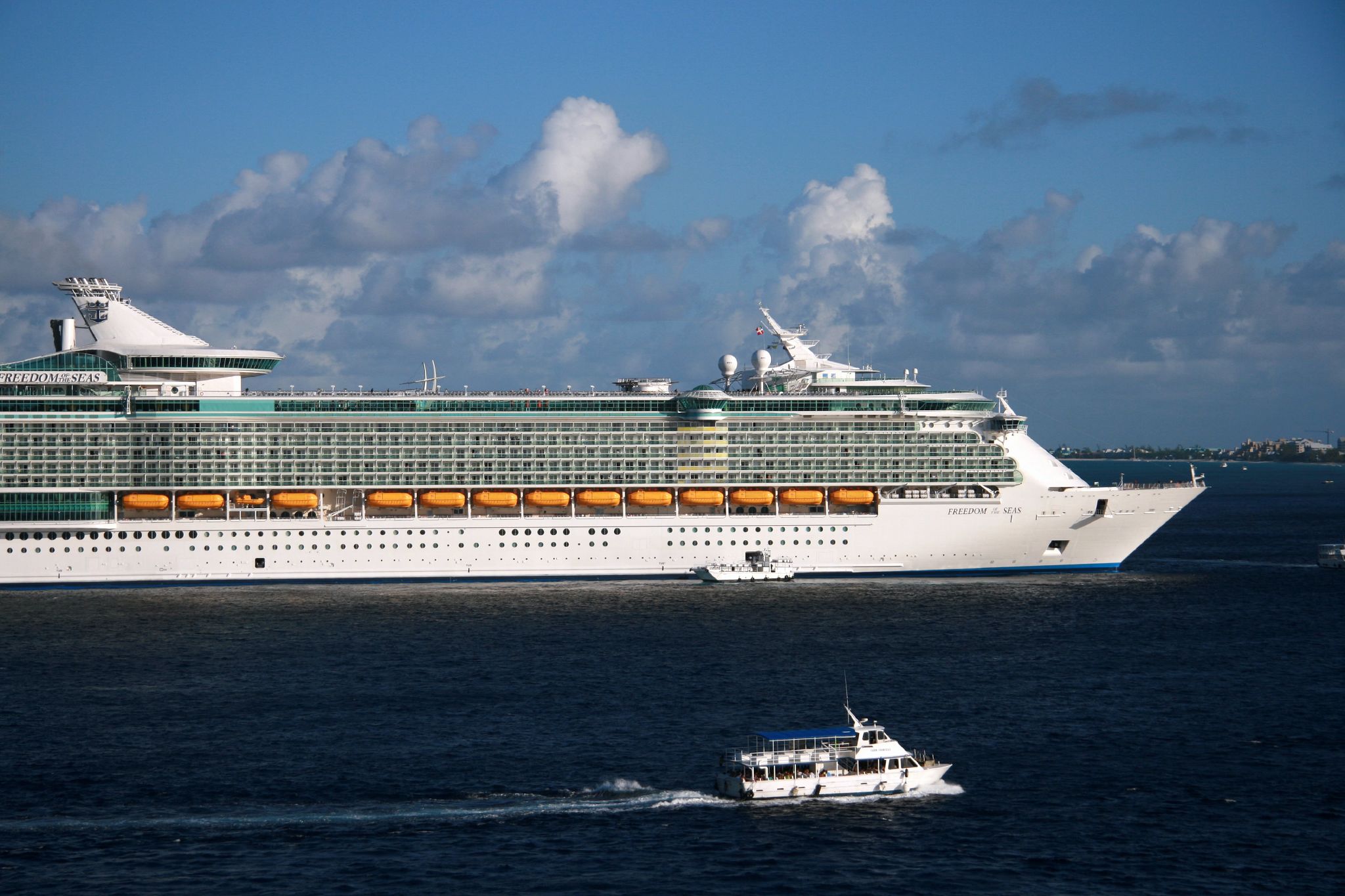
The Cape Liberty Cruise Port is one of three trans-Atlantic passenger terminals in the Port of New York and New Jersey. It is located in Bayonne, New Jersey at the north side of the long pier of the Peninsula at Bayonne Harbor, a former military ocean terminal, and began operations in 2004. History The Cape Liberty Cruise Port is located on a site that had been originally developed for industrial uses in the 1930s and then taken over by the U.S. government during World War II as the Military Ocean Terminal at Bayonne. After conversion of a portion of the site for use as a passenger terminal with full customs and immigration facilities, in May 2004, the '' Voyager of the Seas'' became the first ship to depart from the site, the first time in almost four decades that a passenger ship had departed from a port in the state. The ''Voyager of the Seas'' was one of two ships to have her base of operations shifted to Bayonne from the Manhattan Cruise Terminal on the Hudson River waterfr ... [...More Info...] [...Related Items...] OR: [Wikipedia] [Google] [Baidu] |
Military Ocean Terminal At Bayonne
Military Ocean Terminal at Bayonne (MOTBY) was a U.S. military ocean terminal located in the Port of New York and New Jersey which operated from 1967 to 1999. From 1942 to 1967 the site was the Bayonne Naval Drydock. The site is on Upper New York Bay south of Port Jersey on the eastern side of Bayonne, New Jersey. Since its closure, it has undergone maritime, residential, commercial, and recreational mixed-use development. Part of the Hudson River Waterfront Walkway runs along its perimeter. History In 1932, a basic plan was initiated to build a port terminal off the east coast of Bayonne into the bay to create additional industrial, maritime, and distribution space. After the plan was completed in 1939, dredging and filling began. At the outbreak of World War II, the United States Navy was looking for a location for a port on the East Coast and became interested in the site for a large dry-dock and supply center. The Bayonne Naval Drydock base was opened by the Navy in 1942 a ... [...More Info...] [...Related Items...] OR: [Wikipedia] [Google] [Baidu] |


