|
Port Meadow
Port Meadow is a large meadow of open common land beside the River Thames to the north and west of Oxford, England. Overview The meadow is an ancient area of grazing land, still used for horses and cattle, and according to legend has never been ploughed, at least for around 4,000 years. It is said that in return for helping to defend the kingdom against the marauding Danes, the Freemen of Oxford were given the of pasture next to the River Thames by Alfred the Great who, legend has it, founded the city in the 10th century (although Alfred actually died in the 9th century). The Freemen's collective right to graze their animals free of charge is recorded in the Domesday Book of 1086 and has been exercised ever since. The name may come from Portman, an earlier term for Freeman. The meadow runs from Jericho to Wolvercote (where north of the Shiplake Ditch it becomes Wolvercote Common) along the east (left) bank of the River Thames, with the Cotswold Line railway, the Oxford Ca ... [...More Info...] [...Related Items...] OR: [Wikipedia] [Google] [Baidu] |
Oxford
Oxford () is a City status in the United Kingdom, cathedral city and non-metropolitan district in Oxfordshire, England, of which it is the county town. The city is home to the University of Oxford, the List of oldest universities in continuous operation, oldest university in the English-speaking world; it has buildings in every style of Architecture of England, English architecture since late History of Anglo-Saxon England, Anglo-Saxon. Oxford's industries include motor manufacturing, education, publishing, science, and information technologies. Founded in the 8th century, it was granted city status in 1542. The city is located at the confluence of the rivers Thames (locally known as the Isis) and River Cherwell, Cherwell. It had a population of in . It is north-west of London, south-east of Birmingham and north-east of Bristol. History The history of Oxford in England dates back to its original settlement in the History of Anglo-Saxon England, Saxon period. The name � ... [...More Info...] [...Related Items...] OR: [Wikipedia] [Google] [Baidu] |
Oxford Canal
The Oxford Canal is a narrowboat canal in southern central England linking the City of Oxford with the Coventry Canal at Hawkesbury (just north of Coventry and south of Bedworth) via Banbury and Rugby. Completed in 1790, it connects to the River Thames at Oxford, and links with the Grand Union Canal, which it is combined with for between to the villages of Braunston and Napton-on-the-Hill. The canal is usually divided into the North Oxford Canal (north of Napton, via Rugby to Hawkesbury Junction near Coventry) and the South Oxford Canal, south of Napton to Banbury and Oxford. The canal was for about 15 years the main canal artery of trade between the Midlands and London, via its connection to the Thames, until the Grand Union Canal (then called the Grand Junction Canal) took most of the London-bound traffic following its opening in 1805. The North Oxford Canal (which had been straightened in the 1830s) remained an important artery of trade carrying coal and other c ... [...More Info...] [...Related Items...] OR: [Wikipedia] [Google] [Baidu] |
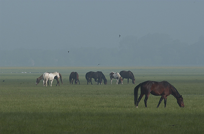
Port Meadow Horses In Mist
A port is a maritime facility comprising one or more wharves or loading areas, where ships load and discharge cargo and passengers. Although usually situated on a sea coast or estuary, ports can also be found far inland, such as Hamburg, Manchester and Duluth; these access the sea via rivers or canals. Because of their roles as ports of entry for immigrants as well as soldiers in wartime, many port cities have experienced dramatic multi-ethnic and multicultural changes throughout their histories. Ports are extremely important to the global economy; 70% of global merchandise trade by value passes through a port. For this reason, ports are also often densely populated settlements that provide the labor for processing and handling goods and related services for the ports. Today by far the greatest growth in port development is in Asia, the continent with some of the world's largest and busiest ports, such as Singapore and the Chinese ports of Shanghai and Ningbo-Zhoushan. As of 2 ... [...More Info...] [...Related Items...] OR: [Wikipedia] [Google] [Baidu] |
Oxford City Council
Oxford City Council is the local authority for the city of Oxford in Oxfordshire, England. Oxford has had a council since medieval times, which has been reformed on numerous occasions. Since 1974, Oxford has been a non-metropolitan district, with county-level functions in the city provided by Oxfordshire County Council. The city council has been under no overall control since 2023. It is based at Oxford Town Hall. History Oxford was an ancient borough, being governed by a corporation from medieval times. The borough gained city status in 1542. It was reformed in 1836 under the Municipal Corporations Act 1835 to become a municipal borough. When elected county councils were created on 1 April 1889, Oxford was initially within the area of Oxfordshire County Council. Seven months later, on 9 November 1889, the city become a county borough, making it independent from the county council. In 1962 the council was given the right to appoint a Lord Mayor. Local government was ref ... [...More Info...] [...Related Items...] OR: [Wikipedia] [Google] [Baidu] |
Nature Reserve
A nature reserve (also known as a wildlife refuge, wildlife sanctuary, biosphere reserve or bioreserve, natural or nature preserve, or nature conservation area) is a protected area of importance for flora, fauna, funga, or features of geological or other special interest, which is reserved and managed for purposes of Conservation (ethic), conservation and to provide special opportunities for study or research. They may be designated by government institutions in some countries, or by private landowners, such as charities and research institutions. Nature reserves fall into different IUCN protected area categories, IUCN categories depending on the level of protection afforded by local laws. Normally it is more strictly protected than a nature park. Various jurisdictions may use other terminology, such as ecological protection area or private protected area in legislation and in official titles of the reserves. History Cultural practices that roughly equate to the establishmen ... [...More Info...] [...Related Items...] OR: [Wikipedia] [Google] [Baidu] |
Burgess Field
Burgess Field Nature Park (also known as Burgess Field) is a nature reserve next to Port Meadow, Oxford, in Oxfordshire, England, managed by Oxford City Council. Overview The site is between Port Meadow to the west and the Cotswold Line, railway line to the east, just north of the Aristotle Lane entrance to Port Meadow and the Trap Ground Allotments. The reserve is on a reclaimed landfill site and is approximately in area. There are open grass areas, some woodland, and a path around the edge of the site, as well as some paths crossing the site. Wildlife includes birds such as Eurasian cuckoo, cuckoo, short-eared owl and jack snipe. The site was used for landfill until the 1980s and is thus higher than Port Meadow, which regularly floods. The area was landscaped, with trees and hedge planting in the 1990s. The name may derive from the Burgess (title), burgesses who endowed Godstow Nunnery with land. John Thompson The site includes a memorial stone to John Thompson (1941–2015) ... [...More Info...] [...Related Items...] OR: [Wikipedia] [Google] [Baidu] |
Buttercup
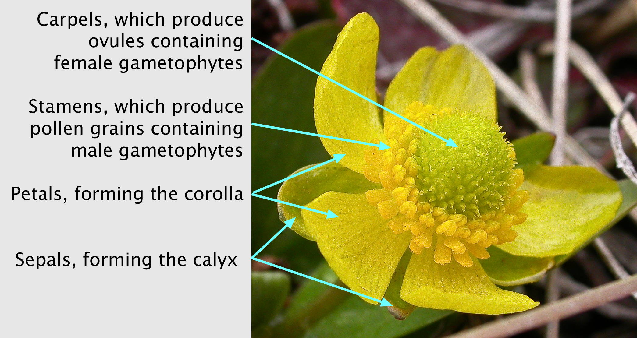
''Ranunculus'' is a large genus of about 1750 species of flowering plants in the family Ranunculaceae. Members of the genus are known as buttercups, spearworts and water crowfoots. The genus is distributed worldwide, primarily in temperate and montane regions. The familiar and widespread buttercup of gardens throughout Northern Europe (and introduced elsewhere) is the creeping buttercup '' Ranunculus repens'', which has extremely tough and tenacious roots. Two other species are also widespread, the bulbous buttercup '' Ranunculus bulbosus'' and the much taller meadow buttercup '' Ranunculus acris''. In ornamental gardens, all three are often regarded as weeds. Buttercups usually flower in the spring, but flowers may be found throughout the summer, especially where the plants are growing as opportunistic colonizers, as in the case of garden weeds. The water crowfoots (''Ranunculus'' subgenus ''Batrachium''), which grow in still or running water, are sometimes treated in a sep ... [...More Info...] [...Related Items...] OR: [Wikipedia] [Google] [Baidu] |
Ice Skating
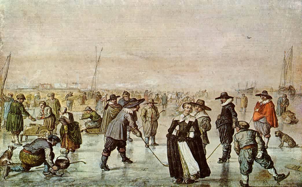
Ice skating is the Human-powered transport, self-propulsion and gliding of a person across an ice surface, using metal-bladed ice skates. People skate for various reasons, including recreation (fun), exercise, competitive sports, and commuting. Ice skating may be performed on naturally frozen bodies of water, such as ponds, lakes, canals, and rivers, and on human-made ice surfaces both indoors and outdoors. Natural ice surfaces used by skaters can accommodate a variety of winter sports which generally require an enclosed area, but are also used by skaters who need Ice rink#Tracks and trails, ice tracks and trails for Tour skating, distance skating and speed skating. Man-made ice surfaces include ice rinks, ice hockey rinks, bandy fields, ice tracks required for the sport of ice cross downhill, and arenas. Various formal sports involving ice skating have emerged since the 19th century. Ice hockey, bandy, rinkball, and ringette are team sports played with, respectively, a flat sl ... [...More Info...] [...Related Items...] OR: [Wikipedia] [Google] [Baidu] |
Fiddler's Island
Fiddler's Island is an island in the River Thames at Oxford in England. It is situated south of Port Meadow on the reach above Osney Lock. The north part of the island sits between the River Thames and the top end of Castle Mill Stream, a Thames backwater. Fiddler's Island Stream flows to the east of the southern part of the island. To the south of the island, there is a short stretch of water known as the Sheepwash Channel linking back to the Castle Mill Stream and the Oxford Canal. The Thames Path runs the length of the complete island. At the northern end, the island has a row of trees along it. On the Castle Mill Stream side there is extensive mooring. The rainbow-shaped Medley Footbridge crosses the main stream of the Thames to the west at the northern end and a flat iron Bailey bridge crosses Castle Mill Stream further south, linking it to Port Meadow to the east. A small footbridge takes the Thames Path along the bank towards Osney Bridge. The northern part of Fiddler' ... [...More Info...] [...Related Items...] OR: [Wikipedia] [Google] [Baidu] |
Site Of Special Scientific Interest
A Site of Special Scientific Interest (SSSI) in Great Britain, or an Area of Special Scientific Interest (ASSI) in the Isle of Man and Northern Ireland, is a conservation designation denoting a protected area in the United Kingdom and Isle of Man. SSSI/ASSIs are the basic building block of site-based nature conservation legislation and most other legal nature/geological conservation designations in the United Kingdom are based upon them, including national nature reserve (United Kingdom), national nature reserves, Ramsar Convention, Ramsar sites, Special Protection Areas, and Special Area of Conservation, Special Areas of Conservation. The acronym "SSSI" is often pronounced "triple-S I". Selection and conservation Sites notified for their Biology, biological interest are known as Biological SSSIs (or ASSIs), and those notified for geological or Physical geography, physiographic interest are Geological SSSIs (or ASSIs). Sites may be divided into management units, with some a ... [...More Info...] [...Related Items...] OR: [Wikipedia] [Google] [Baidu] |
Flood-meadow
A flood-meadow (or floodmeadow) is an area of grassland or pasture beside a river, subject to seasonal flooding.Huhta, Ari‐Pekka, Rautio, Pasi (2014). Flood meadows in Finland - their development during the past century. '' Nordic Journal of Botany'' 32 (6): 858–70 Flood-meadows are distinct from water-meadows in that the latter are artificially created and maintained, with flooding controlledEmma Rothero, Sophie Lake, David Gowing, eds. Floodplain Meadows – Beauty and Utility: A Technical Handbook'' (Floodplain Meadows Partnership; 2016) on a seasonal and even daily basis. Examples Austria: * Hohenau an der March Bosnia and Herzegovina: * List of karst polje in Bosnia and Herzegovina Estonia: * Emajõe flood-meadow * Kasari, Matsalu National Park Finland: * Mattholmsfladan, Pargas * Levänluhta, Isokyrö Ireland: * Shannon Callows United Kingdom: * Angel & Greyhound Meadow, Oxford * Christchurch Meadows, Reading * Christ Church Meadow, Oxford * Mill Mea ... [...More Info...] [...Related Items...] OR: [Wikipedia] [Google] [Baidu] |
Aristotle Lane
Aristotle Lane is a road in north Oxford, England.Aristotle Lane In Christopher Hibbert and Edward Hibbert (editors), The Encyclopaedia of Oxford '. ''Macmillan Publishers, Macmillan'', 1988, page 19. . The lane links North Oxford, leading from the junction of Kingston Road, Oxford, Kingston Road and Hayfield Road (close to the junction with Polstead Road), with Port Meadow to the west, via bridges over the Oxford Canal and railway. The other access to the meadow from North Oxford is via Walton Well Road to the south. St Philip & St James Primary School is located off Aristotle Lane, on Navigation Way, having previously been in Leckford Road to the south. [...More Info...] [...Related Items...] OR: [Wikipedia] [Google] [Baidu] |


