|
North Reef (Spratly Islands)
North Reef may refer to: * North Reef, Solomon Islands *North Reef, Queensland North Reef Light is an active lighthouse located on North Reef, a planar reef, about northeast of Gladstone, Queensland, Australia in the Capricorn and Bunker Group. The lighthouse was constructed on a migratory patch of sand inside a fringin ... ** North Reef Light * North Reef, Paracel Islands * North Reef, Spratly Islands (in the North Danger Reef) See also *in the Spratly Islands: ** Gaven North Reef ** Johnson North Reef aka Collins Reef * North Reef Island (India), one of the Andaman Islands {{geodab ... [...More Info...] [...Related Items...] OR: [Wikipedia] [Google] [Baidu] |
North Reef, Solomon Islands
North Reef is a shallow reef south of Rennell Island. It is one of the three atolls that make up the Indispensable Reefs in the Rennell and Bellona Province of Solomon Islands. The three atolls are steep-to and each encloses a large deep lagoon. They are separated by deep passages two to three kilometres wide. North Reef covers an area 18 km long, and up to 7 km wide. The rim of the atoll has two narrow openings in the north and northwest. The reef covers a total area of 100 km², including lagoon and reef flat. There are no islets. See also *List of islands of Solomon Islands This is a list of islands of Solomon Islands, by province and archipelago. Islands * Choiseul Province **Choiseul Island ** Taro Island ** Vaghena Island (Vaglena, Wagina) * Western Province **Shortland Islands *** Magusaiai *** Alu Island (S ... References Landforms of the Solomon Islands Reefs of Oceania {{Solomons-geo-stub ... [...More Info...] [...Related Items...] OR: [Wikipedia] [Google] [Baidu] |
North Reef, Queensland
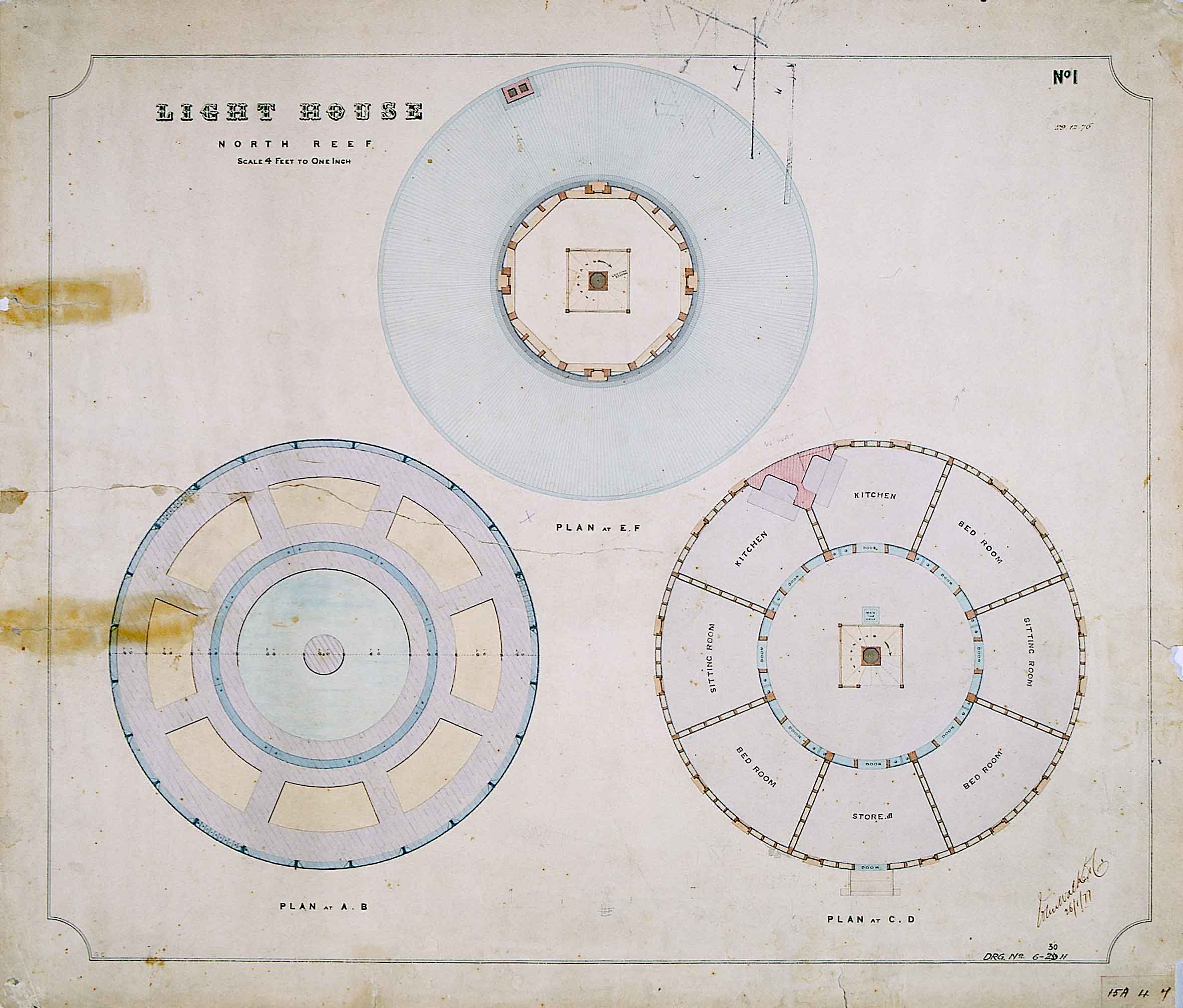
North Reef Light is an active lighthouse located on North Reef, a planar reef, about northeast of Gladstone, Queensland, Australia in the Capricorn and Bunker Group. The lighthouse was constructed on a migratory patch of sand inside a fringing coral reef, which over the years disappeared and reappeared, as sand was washed away and accumulated, and is now a vegetated sandy island. Its construction is unique, having a hollow concrete base that both gives it resistance to the shifting nature of the sandbar and serves as a freshwater tank. As such, it is considered one of the major achievement in Australian lighthouse construction. It is also notable in that due to the harsh conditions, only bachelors were allowed to serve as lighthouse keepers. At it is also the tallest of Queensland's timber-framed iron clad lighthouses. History The recommendation to establish a lighthouse on North Reef was made by a select parliamentary committee in 1864. The site was then a small sandbank on ... [...More Info...] [...Related Items...] OR: [Wikipedia] [Google] [Baidu] |
North Reef Light
North Reef Light is an active lighthouse located on North Reef, a planar reef, about northeast of Gladstone, Queensland, Australia in the Capricorn and Bunker Group. The lighthouse was constructed on a migratory patch of sand inside a fringing coral reef, which over the years disappeared and reappeared, as sand was washed away and accumulated, and is now a vegetated sandy island. Its construction is unique, having a hollow concrete base that both gives it resistance to the shifting nature of the sandbar and serves as a freshwater tank. As such, it is considered one of the major achievement in Australian lighthouse construction. It is also notable in that due to the harsh conditions, only bachelors were allowed to serve as lighthouse keepers. At it is also the tallest of Queensland's timber-framed iron clad lighthouses. History The recommendation to establish a lighthouse on North Reef was made by a select parliamentary committee in 1864. The site was then a small sandbank ... [...More Info...] [...Related Items...] OR: [Wikipedia] [Google] [Baidu] |
North Reef, Paracel Islands
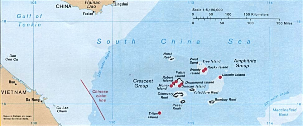
The Paracel Islands, also known as the Xisha Islands () and the Hoang Sa Archipelago ( vi, Quần đảo Hoàng Sa, lit=Yellow Sand Archipelago), are a disputed archipelago in the South China Sea. The archipelago includes about 130 small coral islands and reefs, most grouped into the northeastern Amphitrite Group or the western Crescent Group. They are distributed over a maritime area of around , with a land area of approximately . The name ''Paracel'' is of Portuguese origin, and appears on 16th-century Portuguese maps. The archipelago is approximately equidistant from the coastlines of the People's Republic of China (PRC) and Vietnam, and approximately one-third of the way from central Vietnam to the northern Philippines. The archipelago includes Dragon Hole, the deepest underwater sinkhole in the world. Turtles and seabirds are native to the islands, which have a hot and humid climate, abundant rainfall and frequent typhoons. The archipelago is surrounded by productive fishin ... [...More Info...] [...Related Items...] OR: [Wikipedia] [Google] [Baidu] |
North Reef, Spratly Islands
North Danger Reef (Vietnamese: Cụm Song Tử) () is one of the seven major reefs / banks / etc. in the Spratly Islands area of the South China Sea. It is the most North Western of the features of the Spratly Islands, located to the NW of Dangerous Ground. The reef is a large (8.5 nautical miles) approximately circular atoll with a central lagoon (~20m deep). The surrounding reef is shallow. History Fishermen from Champa were likely the first people to discover the reef. However, later on, the Vietnamese would show interest for the reef. From the 15th century onward, Vietnamese kings began to pay attention to the islands in the South China sea. In 1776, Le Quy Don wrote at Phu Bien Tap Luc about these islands, as well as the establishment and operation of the Paracel fleet (Vietnamese: Hải Đội Hoàng Sa) and the Northern fleet (Vietnamese: Hải Đội Bắc Hải) of Vietnam. In 1838, Emperor Minh Mang of Nguyễn dynasty Vietnam ordered the measurement and illust ... [...More Info...] [...Related Items...] OR: [Wikipedia] [Google] [Baidu] |
Gaven North Reef
The Gaven Reefs, also known in Mandarin and ; Burgos Reefs ( tl, Mga Bahura ng Burgos, lit=Reefs of Burgos); vi, Đá Ga Ven and vi, Đá Lạc, is a group of two reefs in the Tizard Bank of the Spratly Islands in the South China Sea. They are occupied and controlled by China (PRC) as part of Sansha, and claimed by Taiwan (ROC), the Philippines and Vietnam. They have a supply platform and a reef fortress. The northern reef (Nánxūn Jiāo) comprises and its highest point is above sea level. The southern reef (Xīnán Jiāo) comprises . Since 2014, north reef has been subject to significant reclamation activities. Geographical features On 12 July 2016, the tribunal of the Permanent Court of Arbitration concluded that for purposes of Article 121(3) of the Convention, the high-tide features at Gaven Reef (North) are rocks that cannot sustain human habitation or economic life of their own and accordingly shall be entitled to 12nm of territorial sea measured from its baselin ... [...More Info...] [...Related Items...] OR: [Wikipedia] [Google] [Baidu] |
Johnson North Reef
Collins Reef, also known as Johnson North Reef/Johnson Reef North; vi, Đá Cô Lin; Roxas Reef ( tl, Bahura ng Roxas); Mandarin , is a Vietnamese occupied and controlled reef and the westernmost feature of Union Banks Atoll near the centre of Dangerous Ground in the Spratly islands in the South China Sea. It is also claimed by China (PRC), Taiwan (ROC), and the Philippines. Location Collins Reef lies at (), to the northwest of Johnson South Reef Johnson South Reef, also known in Mandarin ; Mabini Reef ( tl, Bahura ng Mabini, lit=Reef of Mabini); vi, Đá Gạc Ma), is a reef in the southwest portion of the Union Banks in the Spratly Islands of the South China Sea. It is controlled by t ..., at the southwestern corner of the Union Banks. References External linksMaritime Transparency Initiative Island Tracker Reefs of the Spratly Islands Union Banks {{vietnam-geo-stub ... [...More Info...] [...Related Items...] OR: [Wikipedia] [Google] [Baidu] |


.jpg)
