|
Nagekeo
Nagekeo Regency (sometimes written as Nagé Kéo) is a regency on the island of Flores in East Nusa Tenggara province of Indonesia, comprising the territory of the Nage people in the south and of the Kéo people in the north (in Aesesa and Wolowae Districts). It covers an area of 1,398.08 km2 and had a population of 130,120 at the 2010 Census,Biro Pusat Statistik, Jakarta, 2011. and 159,732 at the 2020 Census;Badan Pusat Statistik, Jakarta, 2021. the official estimate as at mid 2024 was 168,355 (comprising 83,187 males and 85,168 females).Badan Pusat Statistik, Jakarta, 28 February 2025, ''Kabupaten Nagekeo Dalam Angka 2025'' (Katalog 1102001.5318) The regency was established on 2 January 2007 by separation of the former eastern districts from Ngada Regency; it has its administrative seat (capital) in the town of Mbay on the north coast of Flores. It is bordered to the west by the residual Ngada Regency and to the east by Ende Regency, while to the north is the Flores Sea and ... [...More Info...] [...Related Items...] OR: [Wikipedia] [Google] [Baidu] |
Ngada Regency
Ngada Regency is one of the regencies on the island of Flores, East Nusa Tenggara Province, Indonesia. It is bordered by East Manggarai Regency to the west and Nagekeo Regency to the east, with the Flores Sea to the north and the Sawu Sea to the south. The Regency, which covers an area of 1,736.83 km2, had a population of 142,254 at the 2010 census,Biro Pusat Statistik, Jakarta, 2011. which increased to 165,254 at the 2020 census;Badan Pusat Statistik, Jakarta, 2021. the official estimate as at mid 2024 was 174,088 (comprising 85,909 males and 88,179 females).Badan Pusat Statistik, Jakarta, 28 February 2025, ''Kabupaten Ngada Dalam Angka 2025'' (Katalog 1102001.5312) The town of Bajawa is the capital of Ngada Regency. History The Ngada Regency is one of the older regencies (''kabupaten'') in East Nusa Tenggara, having been formed in 1958. The regency was split into two on 2 January 2007, with the eastern part being formed into a new Nagekeo Regency. With the separate ... [...More Info...] [...Related Items...] OR: [Wikipedia] [Google] [Baidu] |
Flores
Flores is one of the Lesser Sunda Islands, a group of islands in the eastern half of Indonesia. Administratively, it forms the largest island in the East Nusa Tenggara Province. The area is 14,250 km2. Including Komodo and Rinca islands off its west coast (but excluding the Solor Archipelago to the east of Flores), the population was 1,878,875 in the 2020 Census (including various offshore islands); the official estimate as of mid-2024 was 2,014,110.Badan Pusat Statistik, Jakarta, 28 February 2025, ''Provinsi Nusa Tenggara Timur Dalam Angka 2025'' (Katalog-BPS 1102001.53) The largest towns are Ende and Maumere. The name ''Flores'' is of Portuguese origin, meaning "Flowers". Flores is located east of Sumbawa and the Komodo Islands, and west of the Solor Islands and the Alor Archipelago. To the southeast is Timor. To the south, across the Sumba Strait, is Sumba Island, and to the north, beyond the Flores Sea, is Sulawesi. Among all islands containing Indonesia ... [...More Info...] [...Related Items...] OR: [Wikipedia] [Google] [Baidu] |
East Nusa Tenggara
East Nusa Tenggara (; ) is the southernmost province of Indonesia. It comprises the eastern portion of the Lesser Sunda Islands, facing the Indian Ocean in the south and the Flores Sea in the north, with a total land area of 47,238.07 km2. It consists of more than 500 islands, with the largest ones being Sumba, Flores, and the western part of Timor; the latter shares a land border with the separate nation of East Timor. The province is subdivided into twenty-one regencies and the regency-level city of Kupang, which is the capital and largest city. Archaeological research shows that Liang Bua cave in East Nusa Tenggara has been inhabited by humans since about 190,000 years ago. The site was home to early humans, including ''Homo floresiensis'', who were found in the cave's archaeological layers. East Nusa Tenggara is known for its natural beauty such as Komodo National Park, Labuan Bajo, Lake Kelimutu, and exotic beaches. The province is rich in culture, with diverse tribes, la ... [...More Info...] [...Related Items...] OR: [Wikipedia] [Google] [Baidu] |
Mbay (Indonesia)
Mbay is a small town on the north coast of Flores Island, Indonesia, which serves as the administrative capital of Nagekeo Regency (within East Nusa Tenggara East Nusa Tenggara (; ) is the southernmost province of Indonesia. It comprises the eastern portion of the Lesser Sunda Islands, facing the Indian Ocean in the south and the Flores Sea in the north, with a total land area of 47,238.07 km2. It cons ... Province). It comprises two villages (''desa'') which together cover 48.54 km2 and had a combined population of 5,624 at the 2020 Census.Badan Pusat Statistik, Jakarta, 2021. References Populated places in East Nusa Tenggara Regency seats of East Nusa Tenggara Flores Island (Indonesia) {{ENusaTenggara-geo-stub ... [...More Info...] [...Related Items...] OR: [Wikipedia] [Google] [Baidu] |
Ende Regency
Ende Regency is a Regency (Indonesia), regency on the island of Flores, within East Nusa Tenggara Province of Indonesia. The regency covers an area of 2,091.19 km2, and it had a population of 260,605 at the 2010 CensusBiro Pusat Statistik, Jakarta, 2011. and 270,763 at the 2020 Census;Badan Pusat Statistik, Jakarta, 2021. the official estimate as at mid 2024 was 281,371 (comprising 137,961 males and 143,410 females).Badan Pusat Statistik, Jakarta, 28 February 2025, ''Kabupaten Ende Dalam Angka 2025'' (Katalog 1102001.5311) It is bordered to the west by Nagekeo Regency and to the east by Sikka Regency, while the Flores Sea lies to the north and the Savu Sea to the south. The capital is the town of Ende, East Nusa Tenggara, Ende, which lies on a peninsula on the south coast of the Regency; the town comprises four of the regency's districts, with a combined population of 89,519 as at mid 2024. The Kelimutu National Park, which contains the well-known tourist attraction of Mount ... [...More Info...] [...Related Items...] OR: [Wikipedia] [Google] [Baidu] |
Nage People
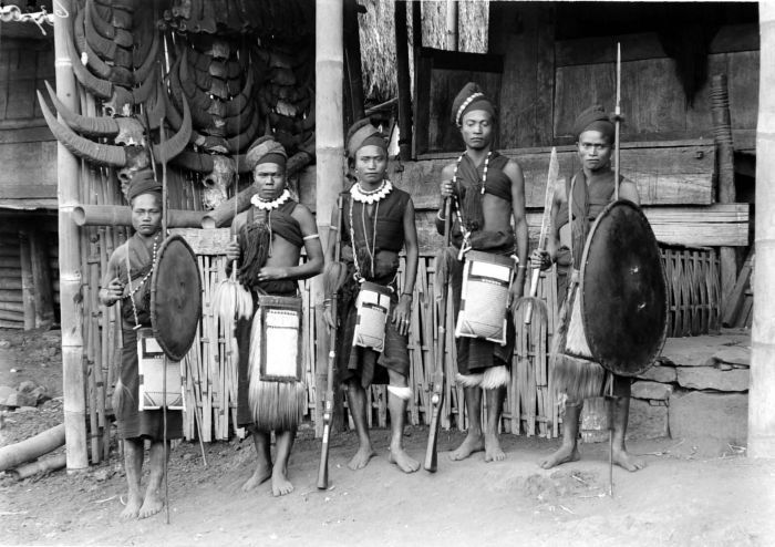
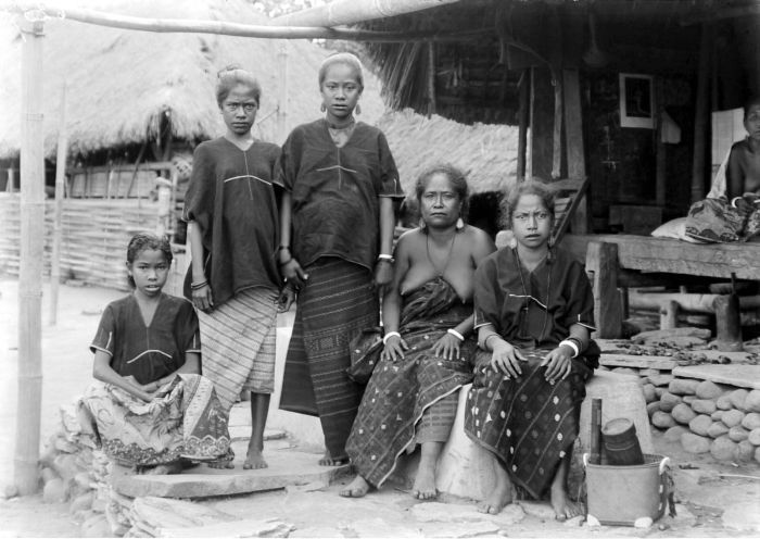
The Nage are an indigenous people living on the eastern Indonesian islands of Flores (chiefly in the eponymous Nagekeo Regency), and Timor. They are descended from the indigenous population of Flores They are largely assimilated by the neighboring people. They speak Nage, one of the major languages in the Austronesian languages group. Agriculture The Nage people mainly engaged in manual slash-and-burn farming (tubers, rice, corn), hunting and gathering. Until the middle of the 20th century, communal land ownership with large families participation were still preserved. They live in cumulus-type settlements, located on the slopes of mountains and surrounded by stone walls. Houses are piled up in rectangular position and connected by an open gallery into a single complex, which is intended for joint residence of several large families. Lifestyle The clothes of the Nage people are loincloth and skirt or ''kain''. Women fasten it over the breast, and men around the waist. The diet i ... [...More Info...] [...Related Items...] OR: [Wikipedia] [Google] [Baidu] |
Kéo Language
Kéo or Nagé-Kéo is a Malayo-Polynesian languages, Malayo-Polynesian dialect cluster spoken by the Kéo and Nage people (ʼata Kéo 'Kéo people') that reside in an area southeast of the Ebu Lobo volcano in the south-central part of Nusa Tenggara Timur Province on the island of Flores, eastern Indonesia, largely in the eponymous Nagekeo Regency. Kéo belongs to the Malayo-Polynesian, Central-Eastern Malayo-Polynesian, Bima-Lembata subgroups of the Austronesian language family and there are approximately 40,000 speakers. Kéo is sometimes referred to as Nage-Kéo, ''Nage'' being the name of a neighbouring ethnic group that is generally considered culturally distinct from Kéo; however, whether or not the two languages are separate entities is ambivalent. Uncommon to Austronesian languages, Kéo is a highly isolating language that lacks inflectional morphology or clear morphological derivation. Instead it relies more heavily on Lexical (semiotics), lexical and syntactic grammat ... [...More Info...] [...Related Items...] OR: [Wikipedia] [Google] [Baidu] |
Regencies Of Indonesia
A regency (; ), sometimes incorrectly referred to as a district and previously known as second-level region, is an administrative division of Indonesia, directly under a Provinces of Indonesia, province and on the same level with City status in Indonesia, city (''kota''). Regencies are divided into Districts of Indonesia, districts (''Kecamatan'', ''Distrik'' in Western New Guinea, Papua region, or ''Kapanewon'' and ''Kemantren'' in the Special Region of Yogyakarta). The average area of Indonesian regencies is about , with an average population of 670,958 people. The English name "regency" comes from the Dutch East Indies, Dutch colonial period, when regencies were ruled by (or regents) and were known as in Dutch language, Dutch ( in Javanese and subsequently Indonesian). had been regional lords under the precolonial monarchies of Java. When the Dutch abolished or curtailed those monarchies, the bupati were left as the most senior indigenous authority. They were not, strictly s ... [...More Info...] [...Related Items...] OR: [Wikipedia] [Google] [Baidu] |
Komodo National Park
Komodo National Park ( Indonesian: ''Taman Nasional Komodo'') is a national park in Indonesia located within the Lesser Sunda Islands in the border region between the provinces of East Nusa Tenggara and West Nusa Tenggara. The park includes the three larger islands Komodo, Padar and Rinca, and 26 smaller ones, with a total area of 1,733 km2 (603 km2 of it land). The national park was founded in 1980 to protect the Komodo dragon, the world's largest lizard. Later it was dedicated to protecting other species, including marine species. In 1991 the national park was declared a UNESCO World Heritage Site and a Man and Biosphere Reserve. It is considered one of the world's 25 biodiversity hotspots. Komodo National Park has been selected as one of the New 7 Wonders of Nature. The waters surrounding Komodo island contain rich marine biodiversity. Komodo islands is also a part of the Coral Triangle, which contains some of the richest marine biodiversity on Earth. It is al ... [...More Info...] [...Related Items...] OR: [Wikipedia] [Google] [Baidu] |
Administrative Village
A village is a human settlement or community, larger than a hamlet but smaller than a town with a population typically ranging from a few hundred to a few thousand. Although villages are often located in rural areas, the term urban village is also applied to certain urban neighborhoods. Villages are normally permanent, with fixed dwellings; however, transient villages can occur. Further, the dwellings of a village are fairly close to one another, not scattered broadly over the landscape, as a dispersed settlement. In the past, villages were a usual form of community for societies that practice subsistence agriculture and also for some non-agricultural societies. In Great Britain, a hamlet earned the right to be called a village when it built a church.-4; we might wonder whether there's a point at which it's appropriate to talk of the beginnings of French, that is, when it wa ... ''village'', from Latin ''villāticus'', ultimately from Latin ''villa'' (English ''villa''). ... [...More Info...] [...Related Items...] OR: [Wikipedia] [Google] [Baidu] |


