|
Mogoditshane
Mogoditshane is a town located in the Kweneng District of Botswana. Population Its population was 14,246 at the 2001 census, and 57,637 at the 2011 census. Gaborone It is in conurbation to the capital Gaborone, whose agglomeration is now home to 421,907 inhabitants, at the 2011 census. Local Football Team The football team is the Mogoditshane Fighters. See also *List of cities in Botswana The following is a list of cities and towns in Botswana with population of over 3,000 citizens. State capitals are shown in boldface. References {{DEFAULTSORT:List Of Cities In Botswana Botswana, List of cities in Botswana ... References Populated places in Botswana Kweneng District {{Botswana-geo-stub ... [...More Info...] [...Related Items...] OR: [Wikipedia] [Google] [Baidu] |
Mogoditshane Fighters
Mogoditshane Fighters are a football (soccer) club from the Mogoditshane in Botswana. The club's nickname is "The Brazilians". Achievements *Mascom Premier League The Botswana Premier League, currently known as the BTC Premiership for sponsorship reasons, is the highest level Association football, football league in Botswana. Organised by the Botswana Football Association, the league was formed in 1978 to ...: 4 ** 1999, 2000, 2001, 2003 * Botswana Challenge Cup: 3 ** 1999, 2000, 2003 * Botswana Independence Cup: 1 ** 2000 Performance in CAF competitions * CAF Champions League: 1 appearance :: 2002 - Preliminary Round * CAF Cup Winners' Cup: 2 appearances ::2000 - First Round ::2001 - First Round Current squad External linksGeoCities site Football clubs in Mogoditshane 1925 establishments in Bechuanaland Protectorate {{Botswana-footyclub-stub ... [...More Info...] [...Related Items...] OR: [Wikipedia] [Google] [Baidu] |
Kweneng District
Kweneng is one of the districts of Botswana and is the recent historical homeland of the Bakwena people, the first group in Botswana converted to Christianity by famed missionary David Livingstone. Various landmarks, including Livingstone's Cave, allude to this history. The seat of the district's government is Molepolole, Botswana's most populous village (only trailing Botswana's two cities: Gaborone and Francistown). It borders Central District in northeast, Kgatleng District on the east, South-East District in southeast, Southern District in south, Kgalagadi District in the west, Ghanzi District in the north. The district is administered by a district administration and district council which are responsible for local administration. Manyana rock paintings in Manyana village and Kgosi Sechele I Museum are the major attractions in the district. As of 2011, the total population of the district was 304,549 compared to 230,335 in 2001. The growth rate of population during ... [...More Info...] [...Related Items...] OR: [Wikipedia] [Google] [Baidu] |
Gaborone
Gaborone ( , , ) is the capital and largest city of Botswana with a population of 246,325 based on the 2022 census, about 10% of the total population of Botswana. Its agglomeration is home to 421,907 inhabitants at the 2011 census. Gaborone is situated between Kgale Hill and Oodi Hill, near the confluence of the Notwane River and Segoditshane River in the south-eastern corner of Botswana, from the South African border. The city is served by the Sir Seretse Khama International Airport. It is an administrative district in its own right, but is the capital of the surrounding South-East District. Locals often refer to the city as ''GC or Motse-Mshate''. The city of Gaborone is named after Chief Gaborone of the Tlokwa tribe, who once controlled land nearby. Because it had no tribal affiliation and was close to fresh water, the city was planned to be the capital in the mid-1960s when the Bechuanaland Protectorate became an independent nation. The centre of the city is a lon ... [...More Info...] [...Related Items...] OR: [Wikipedia] [Google] [Baidu] |
Botswana
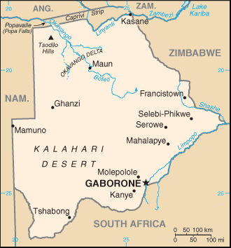
Botswana (, ), officially the Republic of Botswana ( tn, Lefatshe la Botswana, label= Setswana, ), is a landlocked country in Southern Africa. Botswana is topographically flat, with approximately 70 percent of its territory being the Kalahari Desert. It is bordered by South Africa to the south and southeast, Namibia to the west and north, and Zimbabwe to the northeast. It is connected to Zambia across the short Zambezi River border by the Kazungula Bridge. A country of slightly over 2.3 million people, Botswana is one of the most sparsely populated countries in the world. About 11.6 percent of the population lives in the capital and largest city, Gaborone. Formerly one of the world's poorest countries—with a GDP per capita of about US$70 per year in the late 1960s—it has since transformed itself into an upper-middle-income country, with one of the world's fastest-growing economies. Modern-day humans first inhabited the country over 200,000 years ago. The Tswana ethn ... [...More Info...] [...Related Items...] OR: [Wikipedia] [Google] [Baidu] |
List Of Cities In Botswana ...
The following is a list of cities and towns in Botswana with population of over 3,000 citizens. State capitals are shown in boldface. References {{DEFAULTSORT:List Of Cities In Botswana Botswana, List of cities in Botswana Cities A city is a human settlement of notable size.Goodall, B. (1987) ''The Penguin Dictionary of Human Geography''. London: Penguin.Kuper, A. and Kuper, J., eds (1996) ''The Social Science Encyclopedia''. 2nd edition. London: Routledge. It can be def ... [...More Info...] [...Related Items...] OR: [Wikipedia] [Google] [Baidu] |
Districts Of Botswana
Botswana is divided into 10 administrative district A district is a type of administrative division that, in some countries, is managed by the local government. Across the world, areas known as "districts" vary greatly in size, spanning regions or county, counties, several municipality, municipa ...s, two cities, five towns and 11 sub districts. These are administered by 16 local authorities (district councils, city councils or town councils). See also * Sub-districts of Botswana * List of districts of Botswana by Human Development Index * ISO 3166-2:BW *https://www.knowbotswana.com/botswana-cities-and-districts.html *Statistics Botswana Website References {{Articles on first-level administrative divisions of African countries Subdivisions of Botswana Botswana, Districts Botswana 1 Districts, Botswana Botswana geography-related lists ... [...More Info...] [...Related Items...] OR: [Wikipedia] [Google] [Baidu] |
Sub-districts Of Botswana
] The districts of Botswana are subdivided into sub-districts. The sub-districts are listed below, by district: * Bobirwa, headquarters at Bobonong * Boteti, headquarters at Letlhakane * Lerala * Mahalapye * Mmadinare * Mmaphashalala * Mogorosi * Nata * Paje * Rakops * Sebina * Sefhare * Serowe/Palapye * Shoshong * Taupye * Tonota, split from Tutume * Tutume * Lecheng [orapa Chobe District">rapa.html" ;"title="[orapa">[orapa Chobe District * Kasane Ghanzi District * Charles Hill, Botswana, Charleshill * Ghanzi headquarters at New Xhade Kgalagadi District * Hukuntsi * Kang, Botswana, Kang * Tshabong *Khawa *Werda *Makopong *Omaweneno *Tsabong *Kolonkwane *Middlepits *Khuis *Gachibana *Bokspits *Struizendam *Phepheng/Draaihoek *Maubelo *Kokotsha *Maralaleng *Maleshe * Mmathubudukwane *Mochudi *Bokaa *Oodi *Modipane *Mabalane *Sikwane *Malolwane *Ramonaka *Oliphants Drift/ Dikgonnye *Artesia *Malotwana *Leshibitse *Ramathabaki *Kgomodiatshaba Kwenen ... [...More Info...] [...Related Items...] OR: [Wikipedia] [Google] [Baidu] |
Central Africa Time
Central Africa Time or CAT, is a time zone used in central and southern Africa. Central Africa Time is two hours ahead of Coordinated Universal Time ( UTC+02:00), which is the same as the adjacent South Africa Standard Time, Egypt Standard Time, Eastern European Time, Kaliningrad Time and Central European Summer Time. As this time zone is in the equatorial and tropical regions, there is little change in day length throughout the year and so daylight saving time is not observed. Central Africa Time is observed by the following countries: * * * (eastern side only) * * * * * * * * The following countries in Africa also use an offset of UTC+02:00 all-year round: * (observes Egypt Standard Time) * (observes South African Standard Time) * (observes South African Standard Time) * (observes Eastern European Time) * (observes South African Standard Time) See also * Egypt Standard Time, an equivalent time zone covering Egypt, also at UTC+02:00 * Kaliningrad Time, an equivalent ti ... [...More Info...] [...Related Items...] OR: [Wikipedia] [Google] [Baidu] |
Köppen Climate Classification
The Köppen climate classification is one of the most widely used climate classification systems. It was first published by German-Russian climatologist Wladimir Köppen (1846–1940) in 1884, with several later modifications by Köppen, notably in 1918 and 1936. Later, the climatologist Rudolf Geiger (1894–1981) introduced some changes to the classification system, which is thus sometimes called the Köppen–Geiger climate classification system. The Köppen climate classification divides climates into five main climate groups, with each group being divided based on seasonal precipitation and temperature patterns. The five main groups are ''A'' (tropical), ''B'' (arid), ''C'' (temperate), ''D'' (continental), and ''E'' (polar). Each group and subgroup is represented by a letter. All climates are assigned a main group (the first letter). All climates except for those in the ''E'' group are assigned a seasonal precipitation subgroup (the second letter). For example, ''Af'' indi ... [...More Info...] [...Related Items...] OR: [Wikipedia] [Google] [Baidu] |
Semi-arid Climate
A semi-arid climate, semi-desert climate, or steppe climate is a dry climate sub-type. It is located on regions that receive precipitation below potential evapotranspiration, but not as low as a desert climate. There are different kinds of semi-arid climates, depending on variables such as temperature, and they give rise to different biomes. Defining attributes of semi-arid climates A more precise definition is given by the Köppen climate classification, which treats steppe climates (''BSk'' and ''BSh'') as intermediates between desert climates (BW) and humid climates (A, C, D) in ecological characteristics and agricultural potential. Semi-arid climates tend to support short, thorny or scrubby vegetation and are usually dominated by either grasses or shrubs as it usually can't support forests. To determine if a location has a semi-arid climate, the precipitation threshold must first be determined. The method used to find the precipitation threshold (in millimeters): *mult ... [...More Info...] [...Related Items...] OR: [Wikipedia] [Google] [Baidu] |
Populated Places In Botswana
Population typically refers to the number of people in a single area, whether it be a city or town, region, country, continent, or the world. Governments typically quantify the size of the resident population within their jurisdiction using a census, a process of collecting, analysing, compiling, and publishing data regarding a population. Perspectives of various disciplines Social sciences In sociology and population geography, population refers to a group of human beings with some predefined criterion in common, such as location, race, ethnicity, nationality, or religion. Demography is a social science which entails the statistical study of populations. Ecology In ecology, a population is a group of organisms of the same species who inhabit the same particular geographical area and are capable of interbreeding. The area of a sexual population is the area where inter-breeding is possible between any pair within the area and more probable than cross-breeding with ... [...More Info...] [...Related Items...] OR: [Wikipedia] [Google] [Baidu] |


